


Winter Weather Advisory Sunday As Snowfall In Two Parts Affecting Two Different Areas
Saturday Evening Update January 17 2026 One thing I carry after all of my years of forecasting: If one model does a really good job in an active pattern, then…
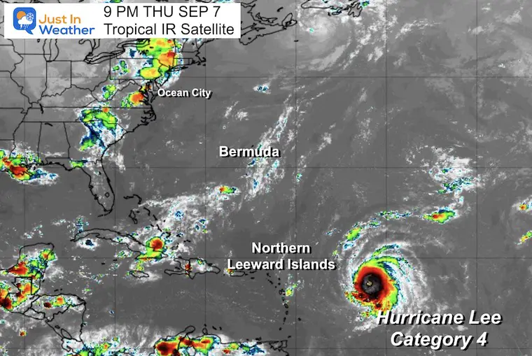
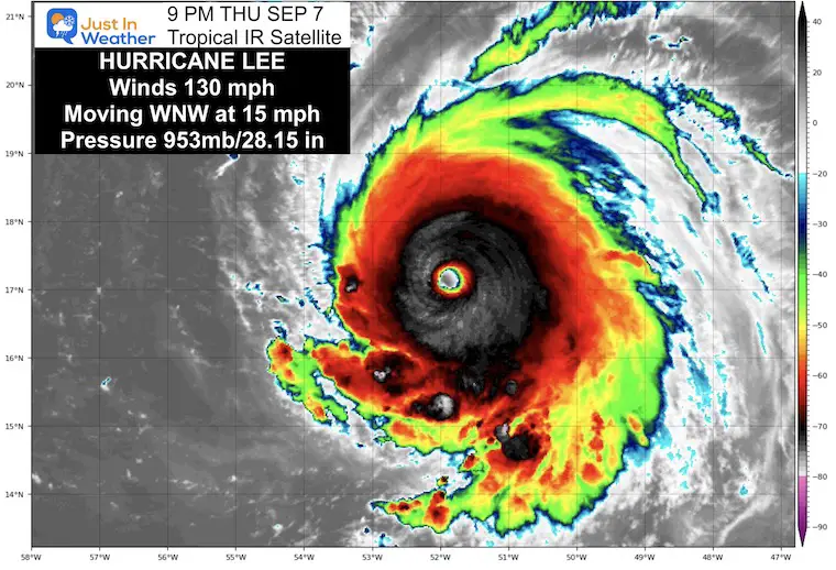
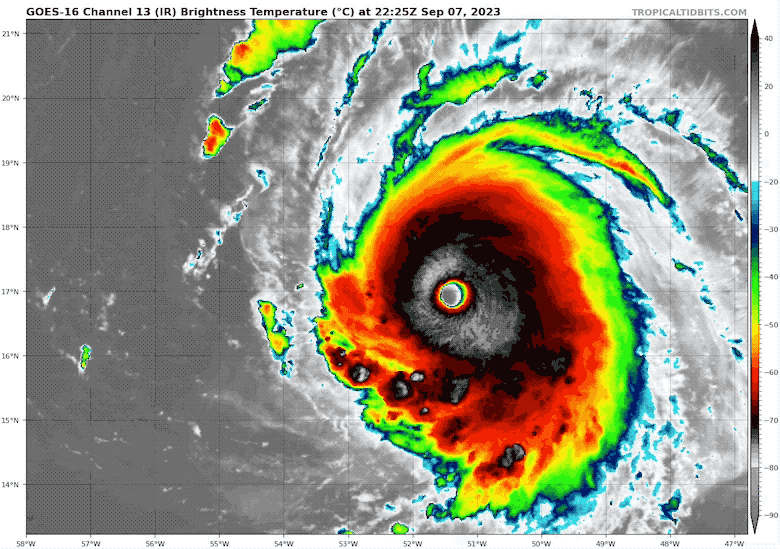
September 7 Thursday Night Update
The theme of rapid intensification for tropical cyclones continues. The warm waters of the central Atlantic have allowed Lee to go from a tropical storm to a hurricane in a day. Then to a major hurricane in a day. Now, we are about to watch something very rare with the achievement of Category 5 intensity tonight.
The next update from the National Hurricane Center will be at 11 PM. If it doesn’t happen by then, it will before the morning.
Since 1924, only 6% of hurricanes have reached the top of the Saffir-Simpson scale. A Category 5 has winds of 157 mph or higher. Contrary to social media rumors, there is no such thing as a Category 6 storm.
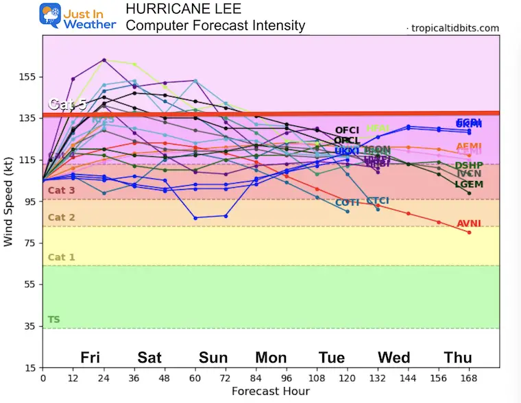
There is strong agreement from computer model guidance and the air force reconnaissance that low sheer and warm water will allow this storm to reach its full potential and remain a major hurricane into next week.
Note: While this will be one of the most powerful storms on record in the Atlantic, it was 780 miles from the nearest land at 5 PM: The Northern Leeward (no relation) Islands.
What we know now is what I will cover in this post. I need to point out that any computer simulation beyond 5 to 7 days has lower accuracy farther out in time. However, the long-range models agree that it will turn north and miss the US Coast. There is some concern for Bermuda and even Eastern Canada.
5 PM Update From The National Hurricane Center
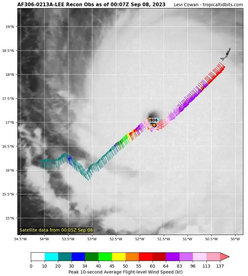
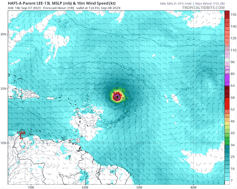
The eye carved out quickly this afternoon. The symmetry is a sign of a very healthy storm with an opportunity to continue to grow.
The first pass shows a whopping 936 mb pressure and winds of 170 mph
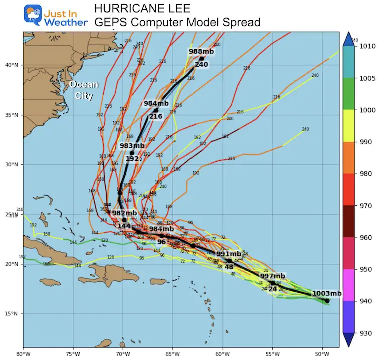
While we see a straight path here, this only goes out 5 days. See the expected turn and why further out in time below.
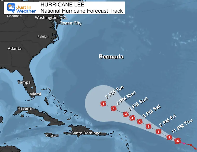
None at this time. It is too far from land, but interests in the Leeward Islands should pay attention over the next few days AND Bermuda next week.
I have been downplaying the potential for Cat 5 to avoid hype. It looks likely now, even with many members of this model ensemble not showing it. They all do support it remaining a major hurricane into next week.
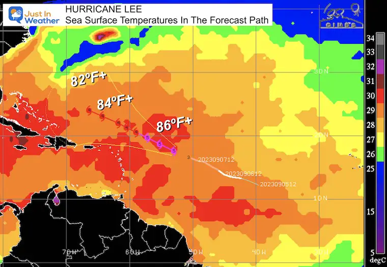
A tropical cyclone needs 78ºF or warmer water to maintain itself. The warmer the water, the stronger the opportunity for the storm to grow.
This will grow to Cat 5 with 86ºF or higher water for a few days. As it eventually travels north and into cooler water, it will gradually weaken.
This is the 126 Hour Forecast showing the storm passing north of the Caribbean Islands. It does not show the curve… yet.
This is the longest range solution I could find plotted. The consensus here has it curving north of the Leeward Islands and missing the US East Coast. It will be closer to Bermuda, but no precise track is reliable at this time.
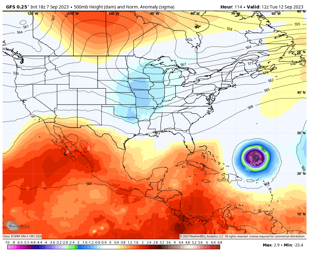
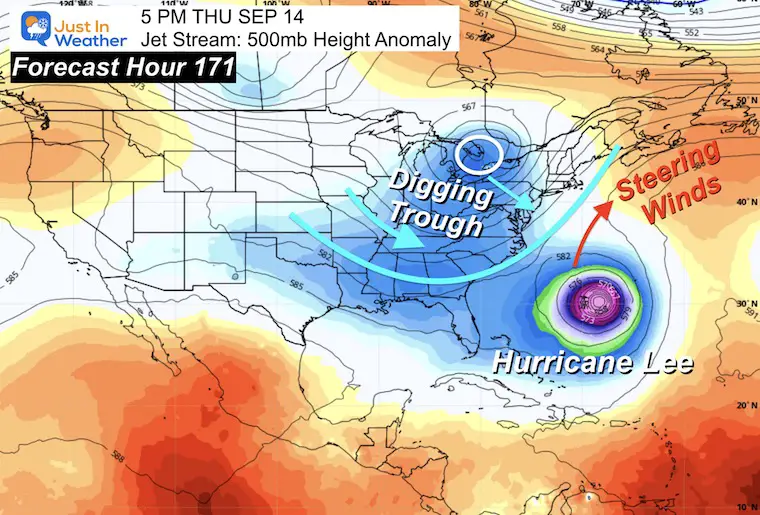
The jet stream at 500 mb shows the upper-level features that will be critical in the long-range projections.
A digging trough of cooler air for the Eastern US is very likely to reach the coast. As a result, this will influence the upper-level winds to steer Hurricane Lee farther north and eventually away from the coast.
Note that this is a 171 Hour Forecast… It is an educated guess and subject to change as time gets closer.
We can see the trough and welcome cooler weather for the Eastern US.
As it reaches cooler water and is affected by the winds, the storm will look more ragged and weaken.
Atmospheric Memory: This is projected to reach the same region that both Major Hurricane Franklin AND Hurricane Idalia also traversed.
Once again we can expect rip currents and perhaps wave heights 4 to 8 Feet, with a potential peak up to 12 Ft along the Mid-Atlantic Coast.
Eye Wall: With a Major Hurricane it is very possible the wave heights may exceed 48 Ft!
I will have a follow-up and recap on our amazing week shortly.

Sign up and be the first to know!

I am aware there are some spelling and grammar typos and occasional other glitches. I take responsibility for my mistakes and even the computer glitches I may miss. I have made a few public statements over the years, but if you are new here, you may have missed it: I have dyslexia and found out during my second year at Cornell University. It didn’t stop me from getting my meteorology degree and being the first to get the AMS CBM in the Baltimore/Washington region. One of my professors told me that I had made it that far without knowing and to not let it be a crutch going forward. That was Mark Wysocki, and he was absolutely correct! I do miss my mistakes in my own proofreading. The autocorrect spell check on my computer sometimes does an injustice to make it worse. I also can make mistakes in forecasting. No one is perfect at predicting the future. All of the maps and information are accurate. The ‘wordy’ stuff can get sticky. There has been no editor who can check my work when I need it and have it ready to send out in a newsworthy timeline. Barbara Werner is a member of the web team that helps me maintain this site. She has taken it upon herself to edit typos when she is available. That could be AFTER you read this. I accept this and perhaps proves what you read is really from me… It’s part of my charm.
#FITF