Tropical Storm Lee About To Become A Major Hurricane: What We Know Now
September 6 Afternoon Update
The latest attention grabber in the Atlantic is Tropical Storm Lee. This was named on Tuesday and is cranking in a hurry. It is likely to become a hurricane today and then a Major Category 3 Hurricane by Friday morning.
This is prime hurricane season! The climatological peak is next week, but for a few weeks, we often see the most activity develop.
This particular storm comes after the rapid development of two major hurricanes last week. Franklin was in the open Atlantic, Idalia ramped up to hit the Gulf Coast of Florida, then passed through the Atlantic and actually crossed some of the same region where Franklin was churning.
Atmospheric Memory Theory supports that this same location may be in the sights of Lee.
What we know now is what I will cover in this post. I need to point out that any computer simulation beyond 5 to 7 days has lower accuracy farther out in time. However, the long-range trend has some support here that may help you with your planning.
What We Know About TS Lee
This is a strong Tropical Storm and getting stronger over warmer water.
It is located 1,200 miles from land, the Leeward Islands. These are the islands in the Northeastern Caribbean Sea, and the name is purely coincidental.
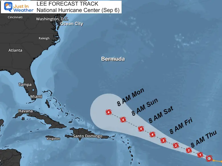
The forecast trend has it staying over the water but becoming a major hurricane. There is one support for Category 4 or even up to a 5!
High surf and rip currents will affect the Eastern US coast next week.
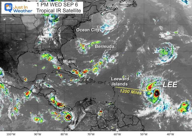
11 AM update From The National Hurricane Center
- LOCATION…14.1N 45.5W
- ABOUT 1200 MI...1930 KM E OF THE NORTHERN LEEWARD ISLANDS
- MAXIMUM SUSTAINED WINDS…70 MPH…110 KM/H
- PRESENT MOVEMENT…WNW OR 285 DEGREES AT 14 MPH…22 KM/H
- MINIMUM CENTRAL PRESSURE…994 MB…29.36 INCHES
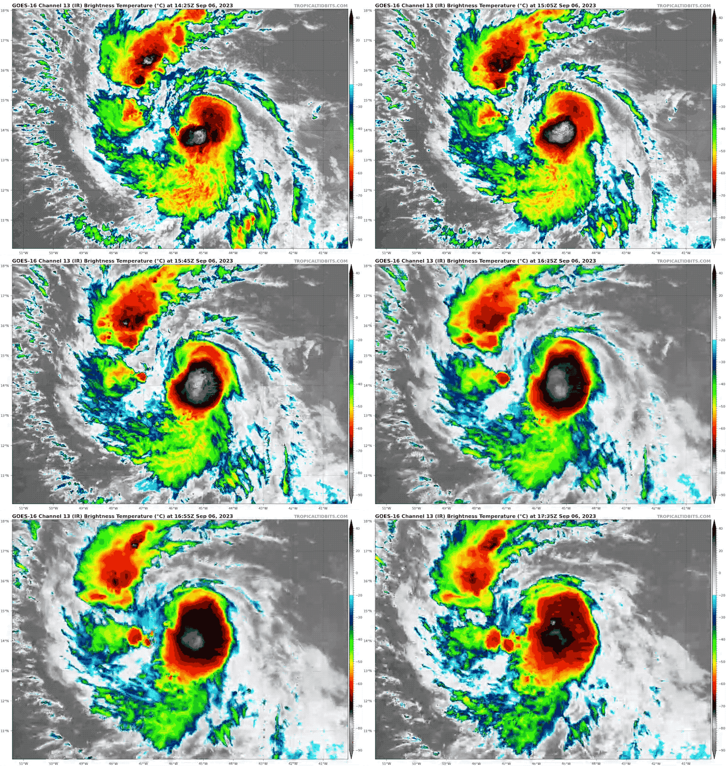
Satellite Loop
See the live radar below…
Hurricane Force Winds Extend 80 Miles From The Center
This has been extrapolated by the Dvorak Technique from satellite data.
Forecast Tracks: National Hurricane Center
Watches and Warnings
None at this time. It is too far from land, but interests in the Leeward Islands should monitor the progress over the next few days AND Bermuda next week.
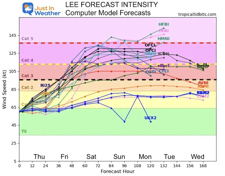
Lee Forecast Intensity – Computer Model Guidance
Based on this guidance, the consensus is for a Category 4 storm with winds over 131 mph. There is a 10% chance it may reach Category 5 next week.
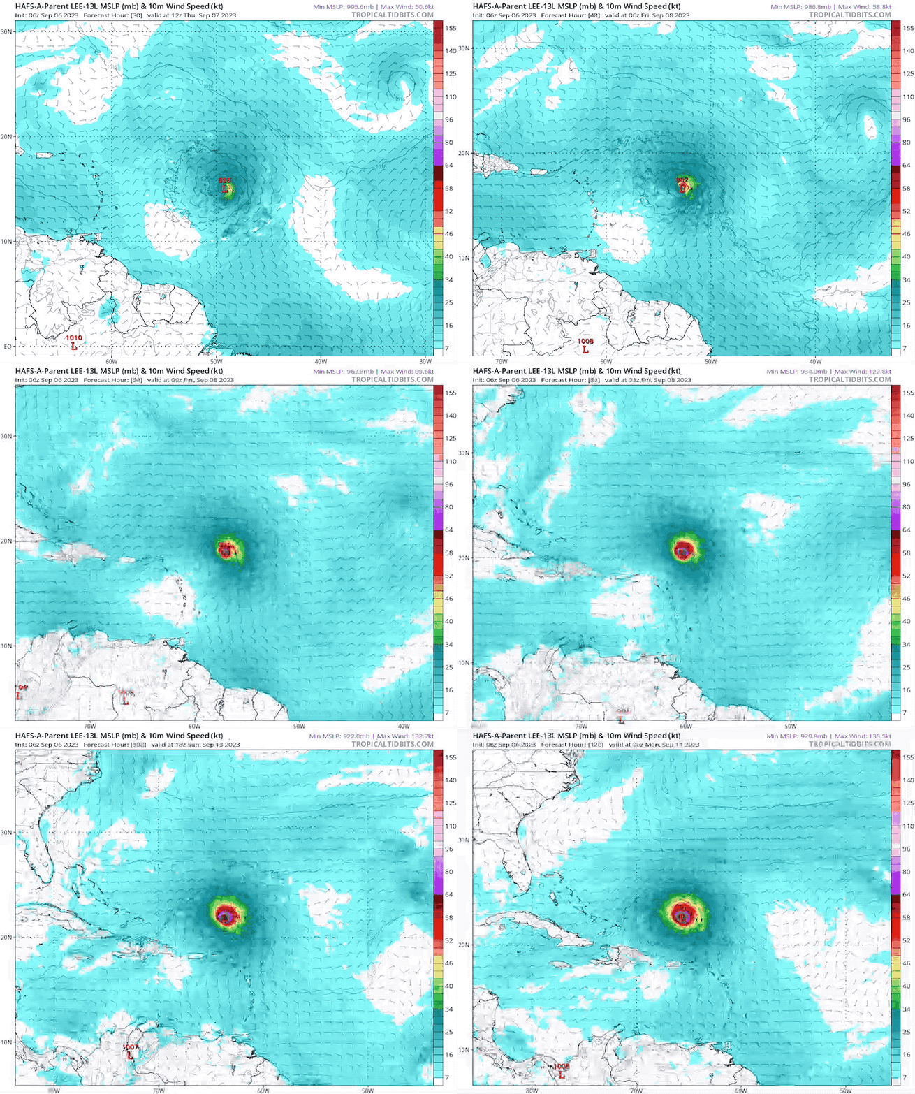
HAFS-A Model Forecast
Thursday Morning to Monday Morning
This is the 126 Hour Forecast showing the storm passing north of the Caribbean Islands. It does not show the curve as of Sunday… yet.
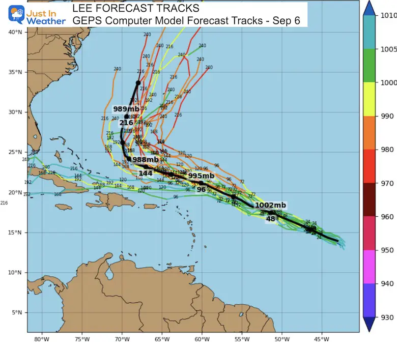
Lee Forecast Tracks – Computer Model Guidance From September 6
This is the longest range solution I could find plotted. The consensus here has it curving north of the Leeward Islands by Monday and missing the US East Coast. It will be closer to Bermuda, but no precise track is reliable at this time.
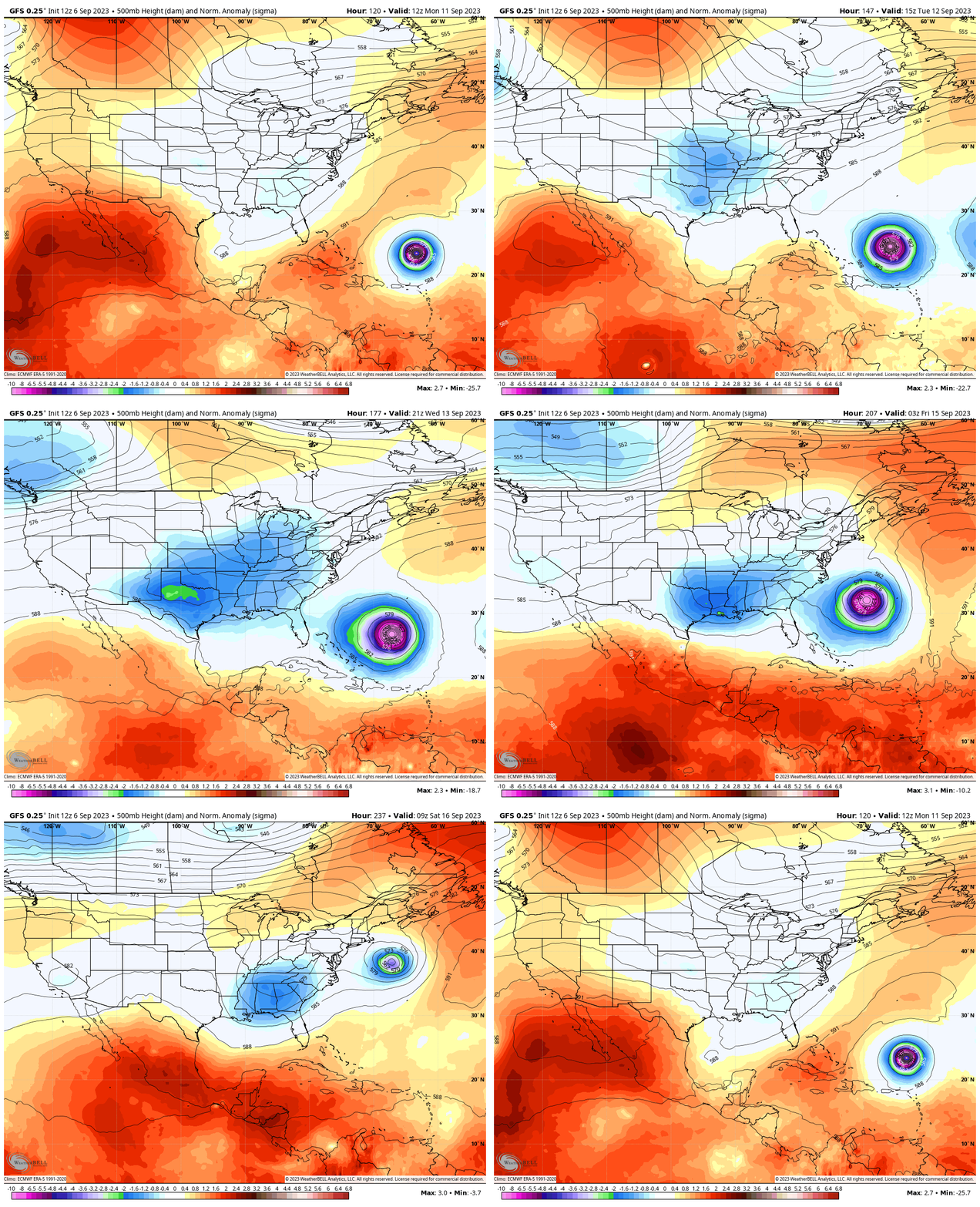
GFS Model
Monday, Sep 11 to Sep 17
I am showing this model because this is the same product that a few days ago had the storm on the East Coast. I didn’t think it was a good idea to show that, but it was passed around on social media, creating a rumor mill.
This is the reason I do not trust long-range forecasting, especially with the first signal of a storm. I still caution this for precision, but it is worth noting now and comparing new runs for consistency or any trends.
Here, we see a mid-latitude trough in the Eastern US that will help curve the hurricane away from the US. This does hint at the chance for impact on Nova Scotia, Canada. I would not lock in on that either yet, but keep it in mind with future plots.
My Thoughts On Long Range Models And Responsible Social Media Protocol
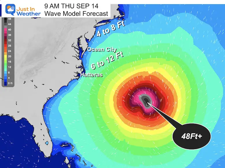
Wave Forecast Thursday, September 14
This is a snapshot of what may be the closest pass to the US. Note that this is more than a full week away and is subject to change.
Atmospheric Memory: This is projected to reach the same region that both Major Hurricane Franklin AND Hurricane Idalia traversed.
Once again, we can expect rip currents and perhaps wave heights of 4 to 8 Feet, with a potential peak of up to 12 Ft along the Mid-Atlantic Coast.
Eye Wall: With a Major Hurricane it is very possible the wave heights may exceed 48 Ft!
EXPLORE MORE
2023 Hurricane Season Forecast With An El Niño Watch
EARLIER THIS MONTH: Maryland Trek 10 For These Kids
I will have a follow-up and recap on our amazing week shortly.
Subscribe for eMail Alerts
Weather posts straight to your inbox
Sign up and be the first to know!
La Niña Has Ended. El Niño May Return By Fall
Aurora Photos From Maryland, Delaware, and Virginia
Please share your thoughts and best weather pics/videos, or just keep in touch via social media
-
Facebook: Justin Berk, Meteorologist
-
Twitter
-
Instagram
RESTATING MY MESSAGE ABOUT DYSLEXIA
I am aware there are some spelling and grammar typos and occasional other glitches. I take responsibility for my mistakes and even the computer glitches I may miss. I have made a few public statements over the years, but if you are new here, you may have missed it: I have dyslexia and found out during my second year at Cornell University. It didn’t stop me from getting my meteorology degree and being the first to get the AMS CBM in the Baltimore/Washington region. One of my professors told me that I had made it that far without knowing and to not let it be a crutch going forward. That was Mark Wysocki, and he was absolutely correct! I do miss my mistakes in my own proofreading. The autocorrect spell check on my computer sometimes does an injustice to make it worse. I also can make mistakes in forecasting. No one is perfect at predicting the future. All of the maps and information are accurate. The ‘wordy’ stuff can get sticky. There has been no editor who can check my work when I need it and have it ready to send out in a newsworthy timeline. Barbara Werner is a member of the web team that helps me maintain this site. She has taken it upon herself to edit typos when she is available. That could be AFTER you read this. I accept this and perhaps proves what you read is really from me… It’s part of my charm.
#FITF


