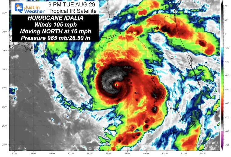
August 29 Tuesday Evening Update
The rapidly strengthening Hurricane Idalia has winds of 105mph, but it is about to become a major Hurricane. We can see the well-defined structure on satellite this evening. Idalia is expected to make landfall as a Category 3 storm by noon Wednesday. That means winds will range between 111 mph to possibly 130 mph, at least with gusts.
In this report, I want to highlight the impact with a zoom-in on the landfall location and track. If you have family, friends, or other interests, I included a closer look at what I believe will be the hardest hit areas around Florida’s Big Bend with landfall.
I have also included the Live Interactive Radar Widget. The eye is already showing up there as well.
8 PM update From The National Hurricane Center
- LOCATION…26.9N 84.7W
- ABOUT 155 MI…250 KM WSW OF TAMPA FLORIDA
- ABOUT 245 MI…390 KM S OF TALLAHASSEE FLORIDA
- MAXIMUM SUSTAINED WINDS…105 MPH…165 KM/H
- PRESENT MOVEMENT…N OR 10 DEGREES AT 16 MPH…26 KM/H
- MINIMUM CENTRAL PRESSURE…965 MB…28.50 INCHES
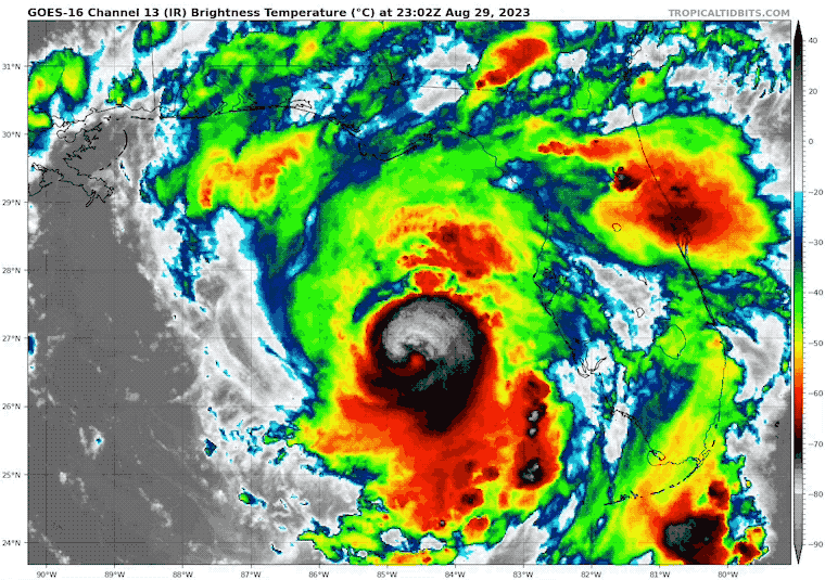
Satellite Loop
See the live radar below…
Hurricane Force Winds Extend 25 Miles From The Center
Tropical Storm Force Winds Extend 160 Miles From The Center
Live Interactive Radar Widget
We can see the eye structure in this image as well.
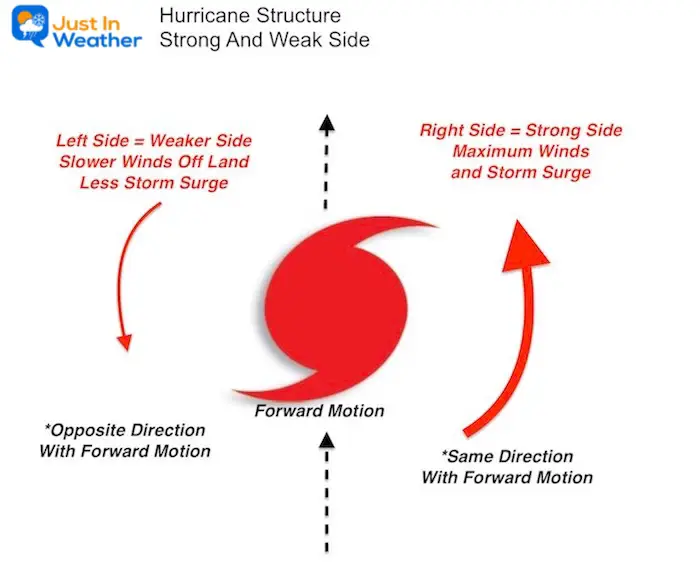
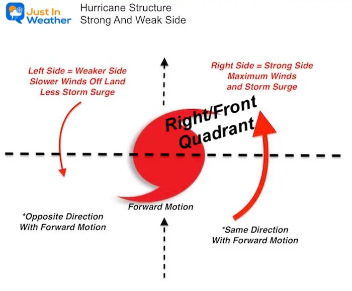
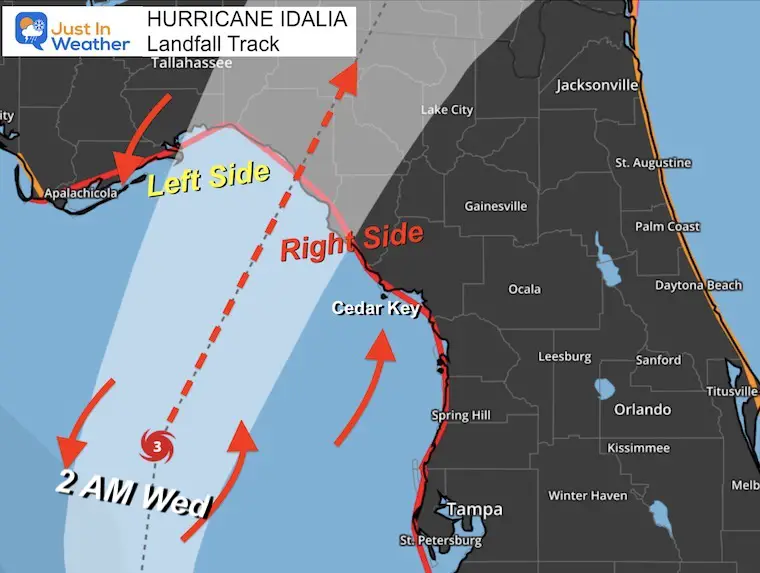
Hurricane Structure: The Stronger Right Front Quad
The strongest winds are within the eye wall itself. If that passes over an area, especially at this speed, the destruction will be widespread.
However, there is a stronger side of the storm in addition to the broader reach of surge, rain, and tornadoes.
In the Northern Hemisphere, storms circulate counter clockwise. This is important with respect to the forward motion. As it moves forward, the right side has winds moving in the same direction as the storm, while the left side is opposite. This makes for a difference in halves.
Right side also carries wind and water onto land.
Left side opposes with wind FROM land… diminishing storm surge.
Breaking down quadrants
The right front quadrant at landfall is the strongest part of the storm.
Forecast Tracks: National Hurricane Center
Watches and Warnings
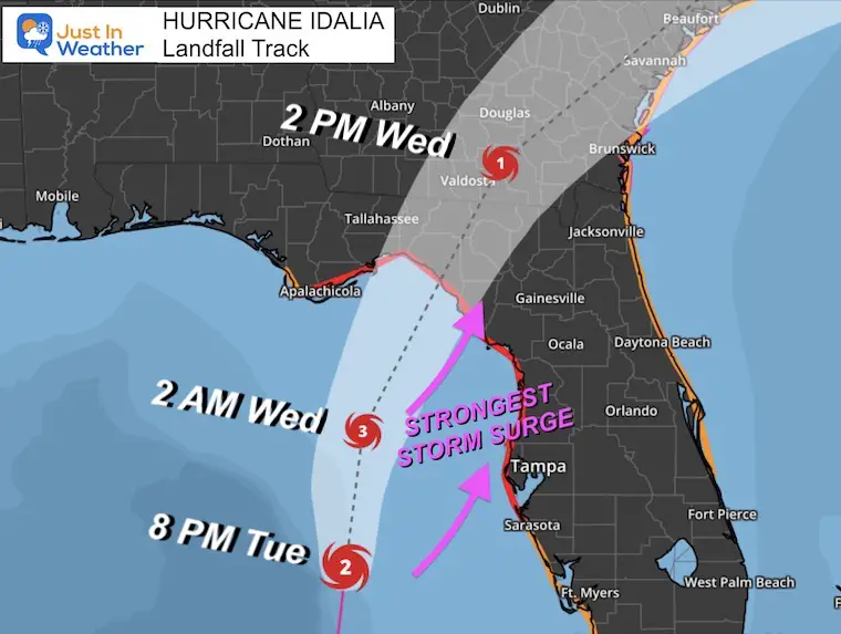
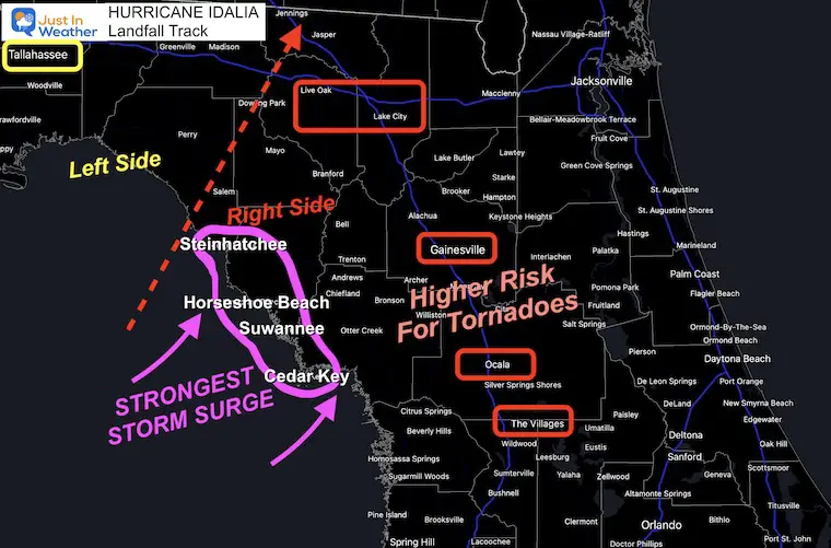
Closer Look At Landfall
Hardest Hit Areas
If there is a 10 to 15 Foot Storm Surge, it would most likely affect:
- Cedar Key
- Suwannee
- Horseshoe Beach
- Steinhatchee
The strongest rain bands and possible tornado areas may include
- The Villages
- Ocala
- Gainesville
- Up through Lake City and Live Oak
The eye is forecast to track by
- Salem
- Downing Park
- And Jasper
Watches and Warnings
This includes landfall in Florida AND the exit off of the South Carolina Coast
A Storm Surge Warning is in effect for…
* Englewood northward to Indian Pass, including Tampa Bay
A Hurricane Warning is in effect for…
* Middle of Longboat Key northward to Indian Pass, including Tampa Bay
A Tropical Storm Warning is in effect for…
* Dry Tortugas Florida
* Chokoloskee northward to the Middle of Longboat Key
* West of Indian Pass to Mexico Beach
* Sebastian Inlet Florida to Surf City North Carolina
A Storm Surge Watch is in effect for…
* Bonita Beach northward to Englewood, including Charlotte Harbour
* Mouth of the St. Mary’s River to South Santee River South Carolina
* Beaufort Inlet to Drum Inlet North Carolina
* Neuse and Pamlico Rivers North Carolina
A Hurricane Watch is in effect for…
* Mouth of the St. Mary’s River to Edisto Beach South Carolina
A Tropical Storm Watch is in effect for…
* Lower Florida Keys west of the west end of the Seven Mile Bridge
* North of Surf City North Carolina to the North Carolina/Virginia border
* Pamlico and Albemarle Sounds
Storm Surge Map And Details
- Aucilla River, FL to Yankeetown, FL…10-15 ft
- Yankeetown to Chassahowitzka, FL…7-11 ft
- Ochlockonee River, FL to Aucilla River, FL…7-11 ft
- Chassahowitzka, FL to Anclote River, FL…6-9 ft
- Anclote River, FL to Middle of Longboat Key, FL…4-6 ft
- Tampa Bay…4-6 ft
- Carrabelle, FL to Ochlockonee River, FL…4-7 ft
- Middle of Longboat Key, FL to Englewood, FL…3-5 ft
- Englewood, FL to Bonita Beach, FL…2-4 ft
- Charlotte Harbor…2-4 ft
- Indian Pass, FL to Carrabelle, FL…3-5 ft
- Mouth of the St. Mary’s River to South Santee, SC…2-4 ft
- Beaufort Inlet to Drum Inlet, NC…2-4 ft
- Pamlico and Neuse Rivers…2-4 ft
- South of Bonita Beach to Chokoloskee, FL…1-3 ft
- South Santee, SC to Beaufort Inlet, NC…1-3 ft
- Drum Inlet to Duck, NC…1-3 ft
- Chokoloskee, FL to East Cape Sable, FL…1-3 ft
- Flagler/Volusia County Line, FL to Mouth of St. Mary’s River…1-3 ft
- Indian Pass to Mexico Beach…1 to 3 ft.
- Florida Keys…1-2 ft
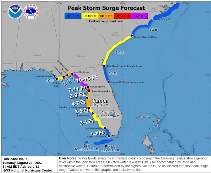
Storm Surge Potential
Tampa Bay may reach historic levels and the slosh model has projected what 4 to 7 feet of water could mean for the city.
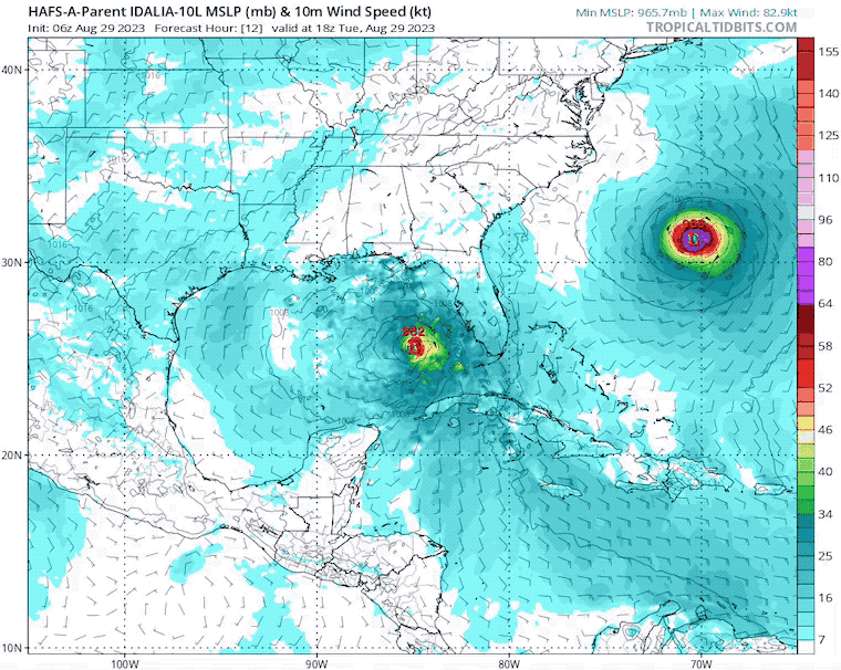
HAFS-A Model Forecast
Tuesday Afternoon to Friday Afternoon
This includes the exiting Hurricane Franklin. Hurricane Idalia will reach the same region where Franklin ‘was’, but they will NOT be there at the same time.
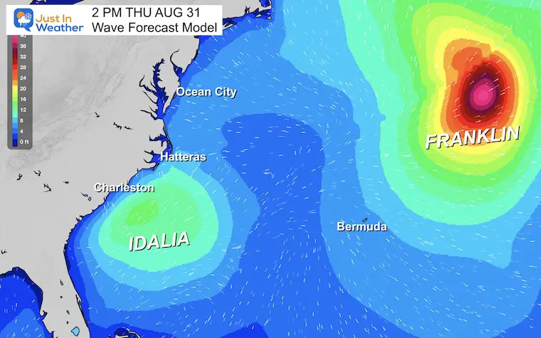
Wave Forecast
This snapshot on Thursday shows where Franklin will be in the Central Atlantic while Idalia will be departing the coast of South and North Carolina. This water will continue across the coast. Waves will average 4 to 6 Ft up to Ocean City, MD.
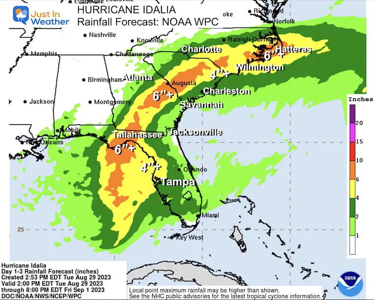
Rainfall Forecast Through Friday
Portions of the west coast of Florida, the Florida Panhandle, southeast Georgia, and the eastern Carolinas: 4 to 8 inches from Tuesday into Thursday. Isolated higher totals of 12 inches are possible, primarily near landfall in northern Florida.
Areas of flash and urban flooding, some of which may be locally significant, are expected across portions of the west coast of Florida, the Florida Panhandle, and southern Georgia Tuesday into Wednesday, spreading into portions of the eastern Carolinas Wednesday into Thursday.
Areas of flash and urban flooding, some of which may be locally significant, are expected across portions of the west coast of Florida, the Florida Panhandle, and southern Georgia Tuesday into Wednesday, spreading into portions of the eastern Carolinas Wednesday into Thursday.
EXPLORE MORE
EARLIER THIS MONTH: Maryland Trek 10 For These Kids
I will have a follow-up and recap on our amazing week shortly.

Subscribe for eMail Alerts

Please share your thoughts, and best weather pics/videos, or just keep in touch via social media
RESTATING MY MESSAGE ABOUT DYSLEXIA
I am aware there are some spelling and grammar typos and occasional other glitches. I take responsibility for my mistakes and even the computer glitches I may miss. I have made a few public statements over the years, but if you are new here, you may have missed it: I have dyslexia and found out during my second year at Cornell University. It didn’t stop me from getting my meteorology degree and being the first to get the AMS CBM in the Baltimore/Washington region. One of my professors told me that I had made it that far without knowing and to not let it be a crutch going forward. That was Mark Wysocki, and he was absolutely correct! I do miss my mistakes in my own proofreading. The autocorrect spell check on my computer sometimes does an injustice to make it worse. I also can make mistakes in forecasting. No one is perfect at predicting the future. All of the maps and information are accurate. The ‘wordy’ stuff can get sticky. There has been no editor who can check my work when I need it and have it ready to send out in a newsworthy timeline. Barbara Werner is a member of the web team that helps me maintain this site. She has taken it upon herself to edit typos when she is available. That could be AFTER you read this. I accept this and perhaps proves what you read is really from me… It’s part of my charm.
#FITF


