


May 11 Aurora Viewing Forecast Weather And More Photos
Saturday May 11, 2024 The display of Northern Lights last night was historic. As the name implies, this is more common in the Northern Latitudes. On rare occasions we can…
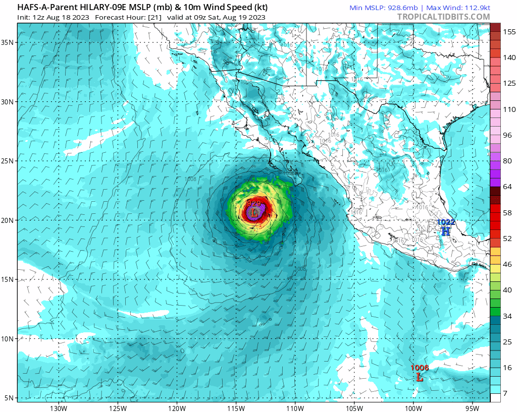
Friday Night Update August 18, 2023
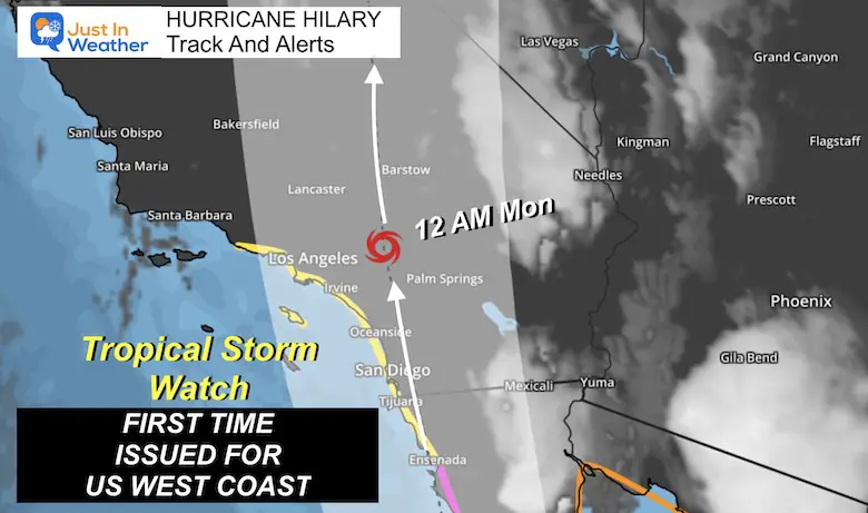
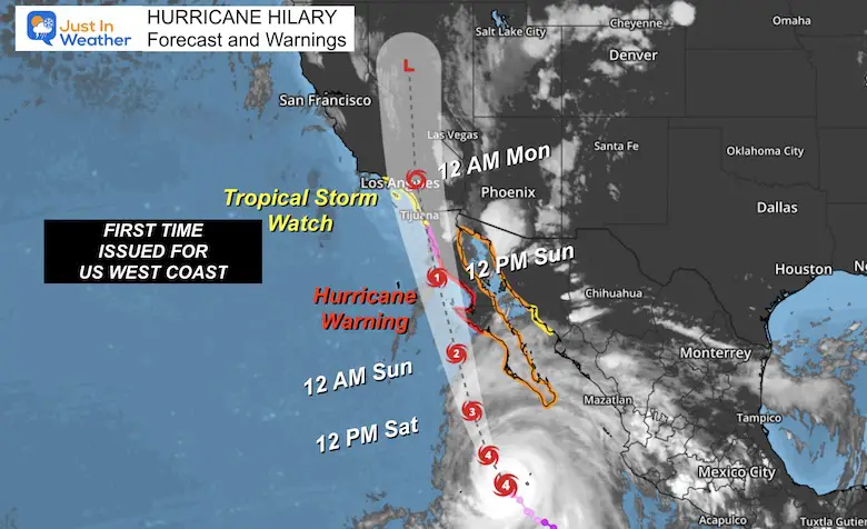
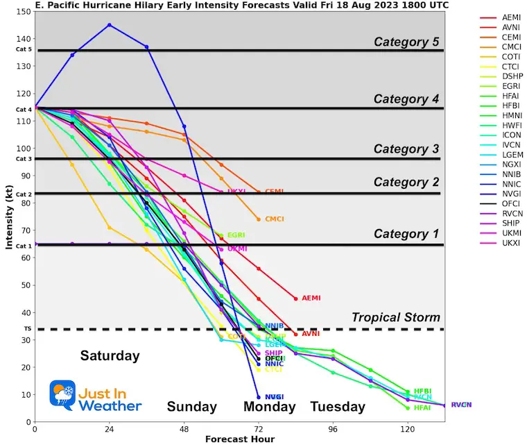
The extra attention on the western United States for Hurricane Hilary has been validated for historic reasons. For the first time in the history of the National Weather Service, a Tropical Storm Watch has been issued for Southern California from Sunday into Monday. This is like to be upgraded to a Warning tomorrow as the storm gets closer.
The storm will be getting weaker and likely drop below 74 mph to lose its hurricane status before reaching California, but it is expected to remain a Tropical Storm. This will carry a tremendous amount of moisture for a few days, leading to extensive flooding across the desert.
That region has experienced strong storms from El Niño and that famed Pineapple Express. However, a tropical cyclone is a true rarity due to the colder water in that area, or storms moving north from Mexico often turn west out into the Pacific.
This will be the first time since 1939. More on the history below.
* Mainland Mexico from Huatabampito to Guaymas
* Baja California north of Ensenada to the California/Mexico border
* California/Mexico border to Point Mugu
* Catalina Island
*San Diego to Los Angeles.
SUMMARY OF WATCHES AND WARNINGS IN EFFECT:
A Hurricane Warning is in effect for…
* Baja California peninsula from Punta Abreojos to Cabo San Quintin
A Hurricane Watch is in effect for…
* Baja California peninsula north of Cabo San Quintin to Ensenada
A Tropical Storm Warning is in effect for…
* Baja California peninsula from Punta Abreojos southward
* Baja California peninsula entire east coast
* Mainland Mexico north of Guaymas
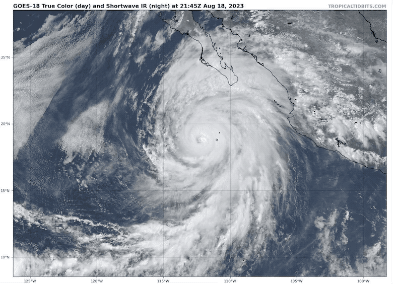
The colder colors are colored brighter and represent higher cloud cover.
A very well-defined EYE and EYE WALL structure shows an extremely powerful storm.
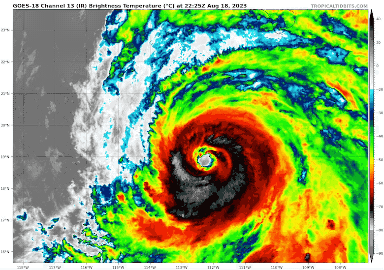
Hurricane Force Winds Extend: 50 miles from the center
Tropical Storm Force Winds Extend: 275 miles from the center
Official Status Report: 2 PM PDT (5 PM EDT) Advisory
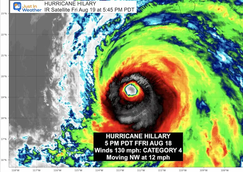
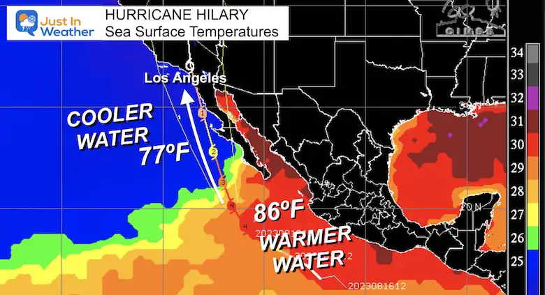
The Sea Surface Temperatures along the path of Hilary highlight why it is beginning to weaken.
The region where it peaked at over 145 mph had temperatures of 86ºF. That is a lot of fuel for a tropical cyclone.
Farther north the water drops into the 70s, which is chilly and not enough to maintain the energy.
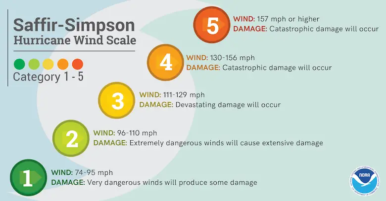
Ranking of Categories Based On Wind Speed
The storm will be weakening, but there are mountains over 10,000 Ft that will still catch high winds over 80 mph. Most areas expect winds of 40 to 65 mph.
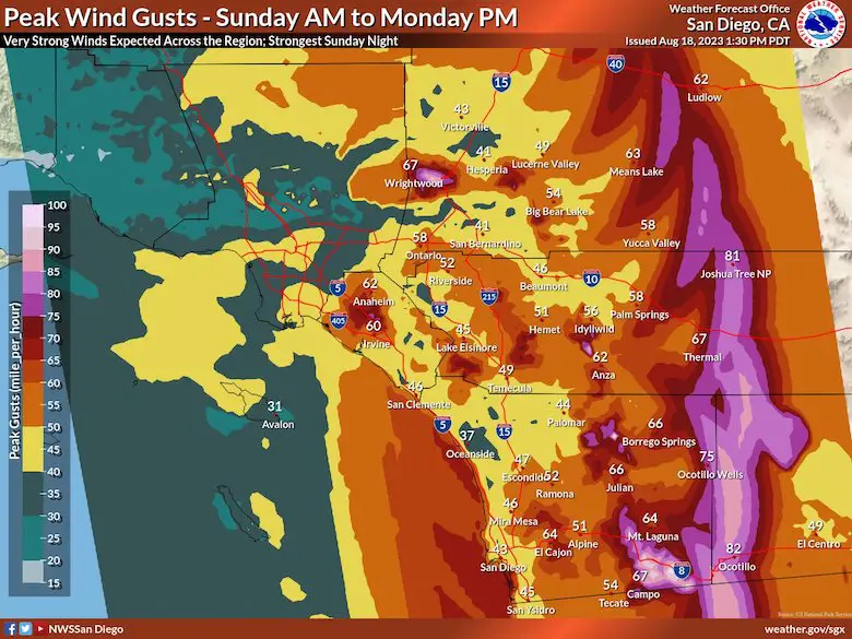
Southern California from NWS San Diego
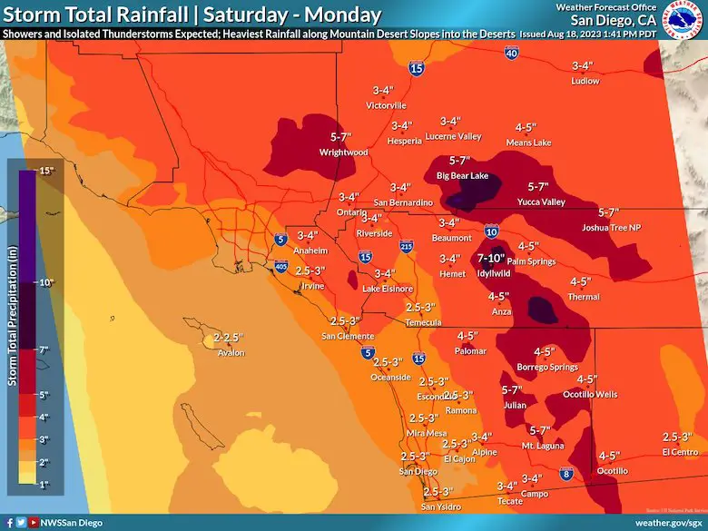
RAINFALL:
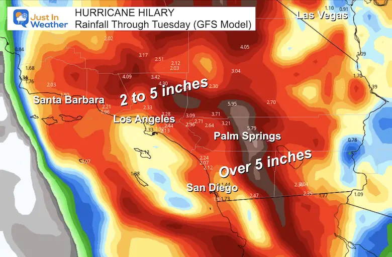
Heavy rainfall in association with Hilary is expected to impact the Southwestern United States through next Wednesday, peaking on Sunday and Monday. Rainfall amounts of 3 to 6 inches, with isolated amounts of 10 inches, are expected across portions of southern California and southern Nevada. Dangerous to locally catastrophic flooding will be possible. Elsewhere across portions of the Western United States, rainfall totals of 1 to 3 inches are expected, resulting in localized flash flooding.
Sunday Morning to Monday Morning
Use the controls to scroll through the timeline or zoom in closer.
Since 1900 there have been 2
1939 – The last landfall, 86 years ago!
Taking a look back at our tropical landfall history…well my word, it’s been a long time! We have seen close encounters from previous systems, but the last time a tropical system made landfall in SoCal was back in 1939. A hurricane? 165 years ago in 1858! 📷 #CAwx #History pic.twitter.com/d0NtAkhaJ7
— NWS San Diego (@NWSSanDiego) August 18, 2023
I will have a follow-up and recap on our amazing week shortly.


I am aware there are some spelling and grammar typos and occasional other glitches. I take responsibility for my mistakes and even the computer glitches I may miss. I have made a few public statements over the years, but if you are new here you may have missed it: I have dyslexia, and found out during my second year at Cornell University. It didn’t stop me from getting my meteorology degree and being the first to get the AMS CBM in the Baltimore/Washington region. One of my professors told me that I had made it that far without knowing and to not let it be a crutch going forward. That was Mark Wysocki, and he was absolutely correct! I do miss my mistakes in my own proofreading. The autocorrect spell check on my computer sometimes does an injustice to make it worse. I also can make mistakes in forecasting. No one is perfect at predicting the future. All of the maps and information are accurate. The ‘wordy’ stuff can get sticky. There has been no editor that can check my work when I need it and have it ready to send out in a newsworthy timeline. Barbara Werner is a member of the web team that helps me maintain this site. She has taken it upon herself to edit typos when she is available. That could be AFTER you read this. I accept this and perhaps proves what you read is really from me… It’s part of my charm.
#FITF