July 9, 2023
Sunday Mid-Day Update
The one thing about the weather so far is that it is behaving as expected. Showers and thunderstorms began to pop up during the morning. This gives us a signal that the atmosphere is unstable and energized. This justifies the Severe Thunderstorm Watch issued for our region. This is added to the Flood Watch already in place. Many areas overlap but not all. See the maps below.
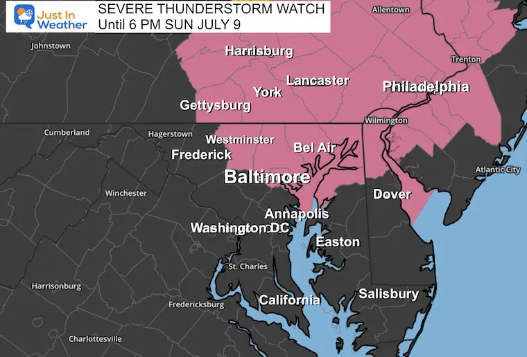
Severe Thunderstorm Watch
These shaded counties have the risk for thunderstorms up to 6 PM to build up to these conditions:
- Winds over 60 mph
- Hail over 1-inch in diameter
- Isolated Tornadoes
This is potential, not a promise. The prime area is NORTH of Annapolis including metro Baltimore to Southern Pennsylvania. There still may be strong or severe storms into southern Maryland and Delmarva, so please do not let your guard down, based on this map. This is highlighting the ‘more likely’ locations.
If any storm does reach these limits a warning will be issued with more specific towns in the path.
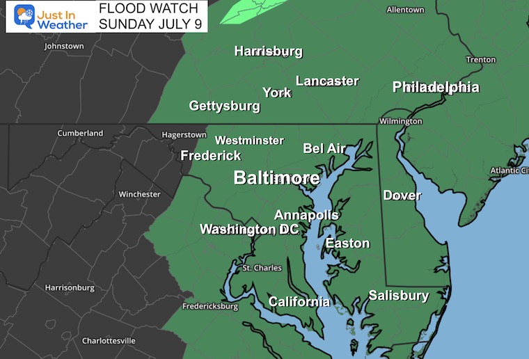
Flood Watch
Multiple storm cells and some slow moving or training over the same area may produce quick rain totals between 1 to 3 inches. As we saw earlier in the week, some spots could get even more.
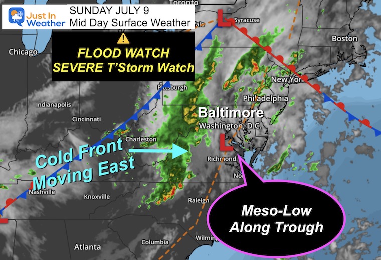
Weather Set Up
As we move into the afternoon and evening, the heat of the day will combine with Low Pressure to enhance mesoscale circulation. This will get an added boost from the cold front approaching from the west to pulse multiple storm cells and heavy rain over the span of many hours.
The best I can do is show you the live radar AND compare it to multiple model forecasts. There is a variety of suggestions, but the common thread is for the window of heavy rain and storms in central areas to be from 2 PM to 6 PM. This evening will show the shift to Delmarva and the beaches.
Live Radar and Lightning Widget
Compare to the forecast maps below.
Radar Simulations
Compare three High Resolution Forecasts Below
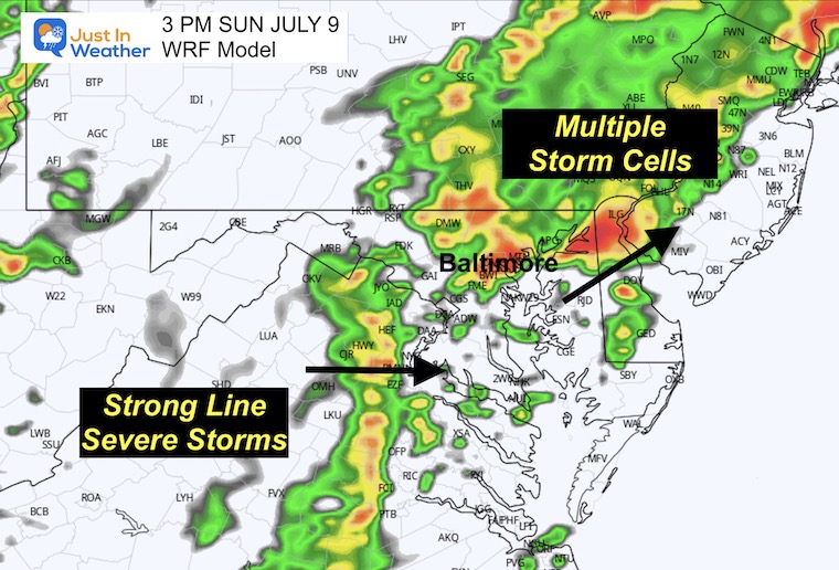
WRF Model Noon to 11 PM
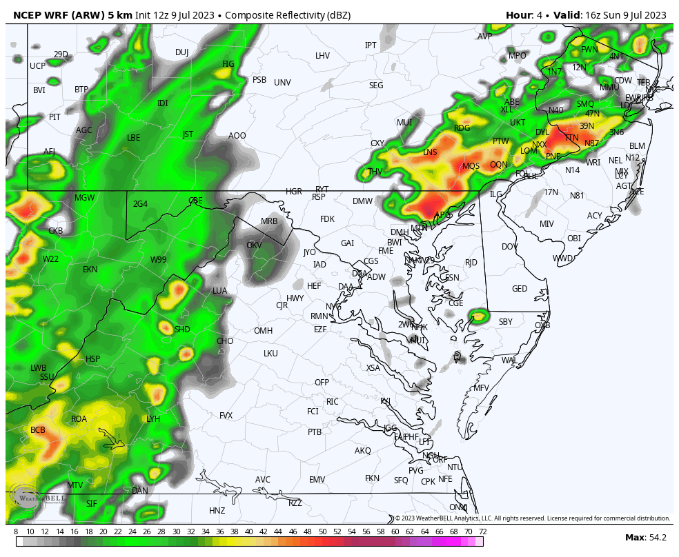
3 PM Snapshot
Multiple Storm Cells moving to the North and Northeast, with a line of severe storms with the cold front will approach central areas. This suggests many hours of stormy activity, so you could get a few separate boomers or one lingering into another.
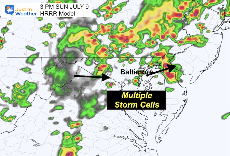
HRRR Model Noon to 11 PM
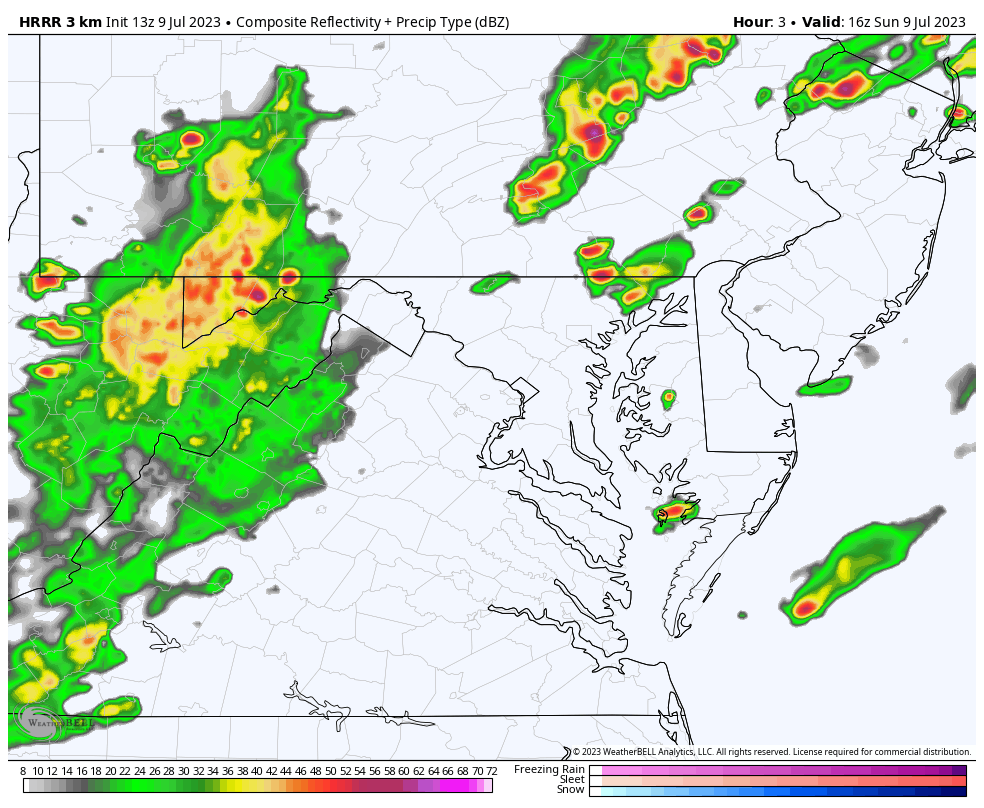
3 PM Snapshot
Multiple storm cells scattered across the region.
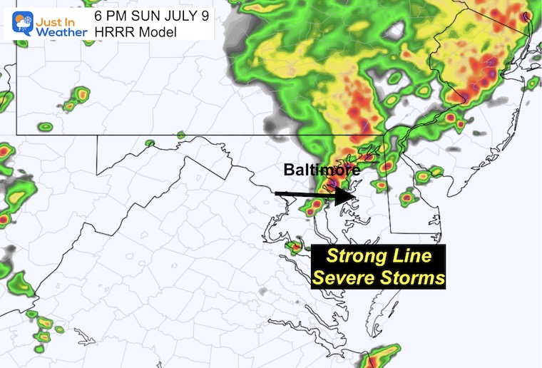
6 PM Snapshot
This suggestion pushes the line of severe storms through metro Baltimore around 6 PM. It may end up a little faster than this.
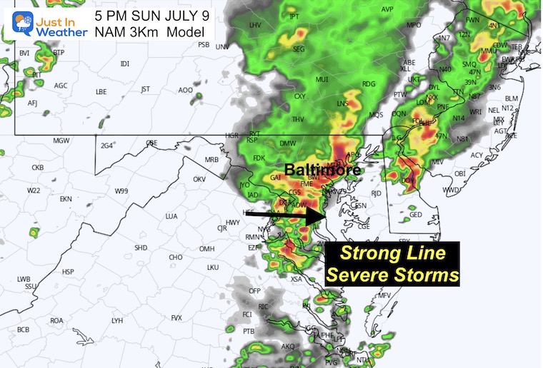
NAM 3 Km Model Noon to 11 PM
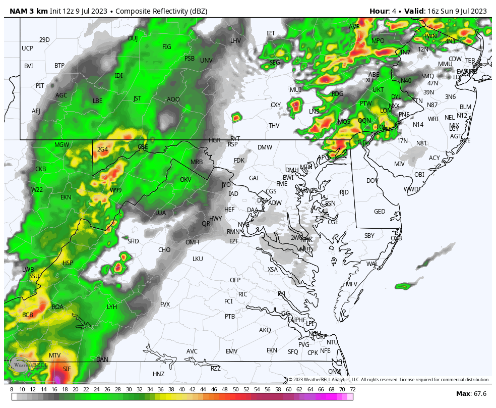
5 PM Snapshot
This model also suggests the peak of activity reaching central areas within 60 to 100 miles of Baltimore late afternoon. This time frame has sped up a little.
More Storm Outlook Maps Used Today
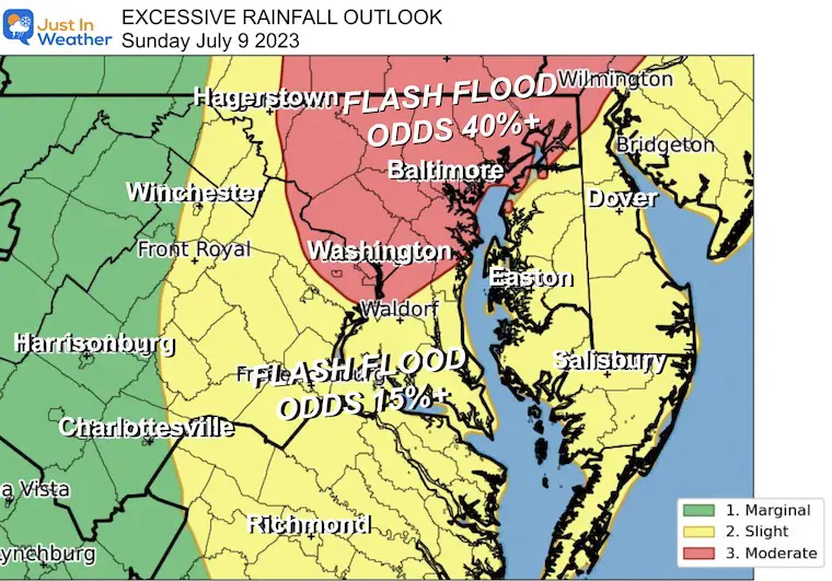
Excessive Rainfall Outlook
NOAA’s Storm Prediction Center issued a Moderate Risk (in red) for our region on Sunday. This includes Washington, Baltimore, York, and central Pennsylvania where there is a GREATER THAN 40% Chance Flash Flood Warnings will be issued.
The potential is for local storms that can easily drop 1 to 3 inches of rain in a hurry. But as we have seen in the past week, some storms can drop over 5 inches of rainfall enhancing the risk of flash flooding.
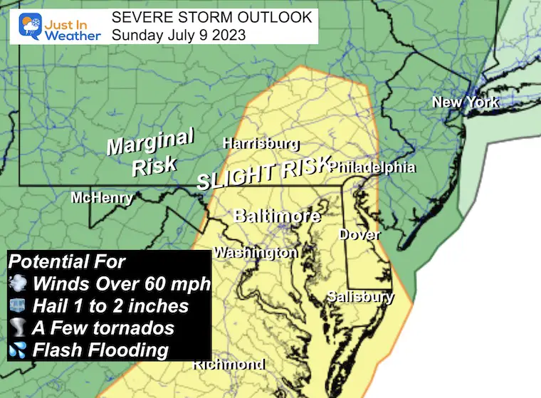
NOAA Severe Storm Risk
There may be showers in the morning, but the main event will be with the cold front later afternoon.
‘Slight Risk’ means a higher chance for storms to produce:
- Damaging winds over 60 mph
- Hail over 1 inch in diameter
- A few tornadoes
- Flash Flooding
Looking Ahead
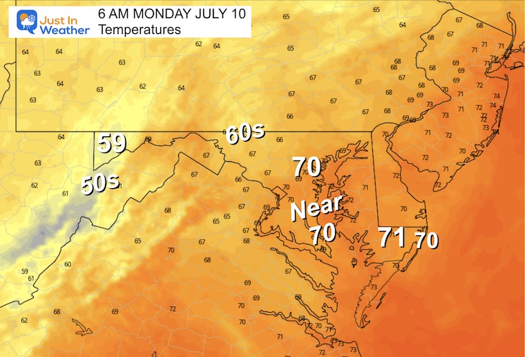
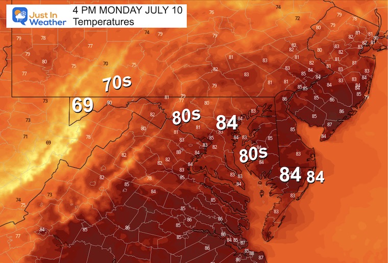
Monday Weather
Morning Temperatures
Afternoon Temperatures
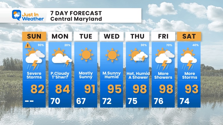
7 Day Forecast
After the storms today, we will get a break in the week ahead. The next cycle of weather will gradually build the temperatures to eventually crank full heat later in the week: Mid to Upper 90s after Wednesday!
The next round of strong to severe storms may set up for Friday and Saturday.
Subscribe for eMail Alerts
EXPLORE MORE

Please share your thoughts, and best weather pics/videos, or just keep in touch via social media
RESTATING MY MESSAGE ABOUT DYSLEXIA
I am aware there are some spelling and grammar typos and occasional other glitches. I take responsibility for my mistakes, and even the computer glitches I may miss. I have made a few public statements over the years, but if you are new here you may have missed it: I have dyslexia, and found out during my second year at Cornell University. It didn’t stop me from getting my meteorology degree, and being the first to get the AMS CBM in the Baltimore/Washington region. One of my professors told me that I had made it that far without knowing, and to not let it be a crutch going forward. That was Mark Wysocki and he was absolutely correct! I do miss my mistakes in my own proofreading. The autocorrect spell check on my computer sometimes does an injustice to make it worse. I also can make mistakes in forecasting. No one is perfect predicting the future. All of the maps and information are accurate. The ‘wordy’ stuff can get sticky. There has been no editor that can check my work when I needed it and have it ready to send out in a newsworthy timeline. Barbara Werner is a member of the web team that helps me maintain this site. She has taken it upon herself to edit typos, when she is able. That could be AFTER you read this. I accept this and perhaps proves what you read is really from me… It’s part of my charm.
#FITF


