July 8 Turning Very Humid With Severe Storms More Likely Sunday
July 8, 2023
Saturday Morning Update
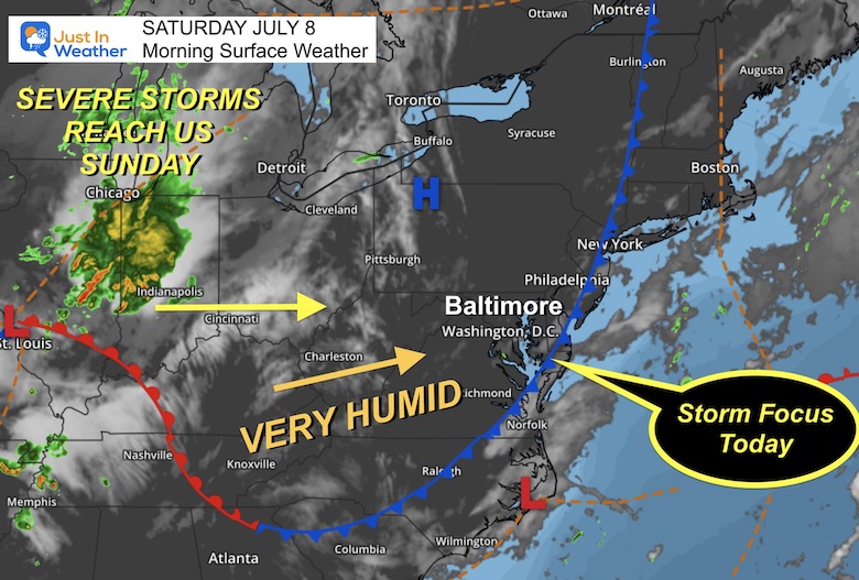
This is one of those days where the weather map and names of symbols can be deceiving. A cold front has moved to the eastern part of our region, but the air is not really cooler behind it. This boundary has shifted the focus for storms to Delmarva today AND an air mass with more moisture will pump up the humidity today and tonight.
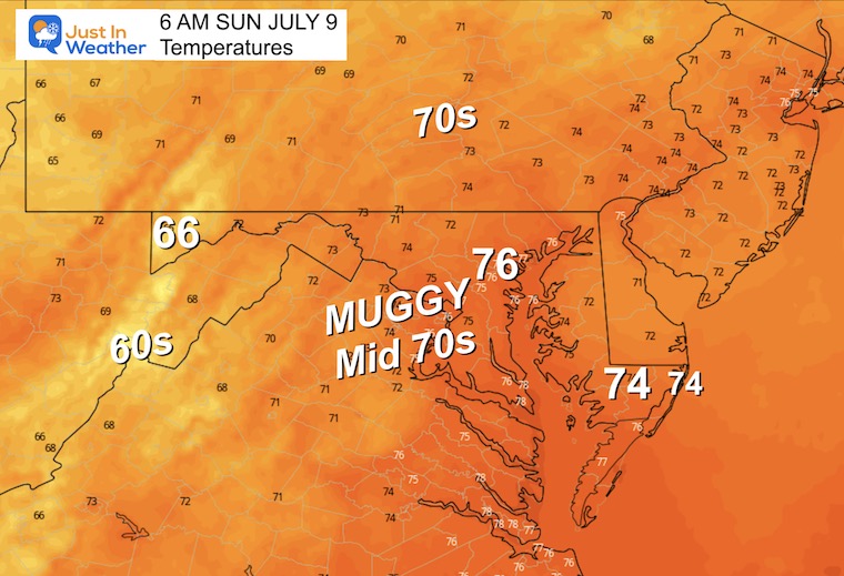
Overnight tonight and Sunday morning will be the most muggy we have experienced in a long time. Models are showing most of the region will remain in the mid to upper 70s Sunday morning. This will provide lots of energy for storms on Sunday to turn severe!
The week ahead will bring in the hottest air of the year.
Morning Surface Weather
The cold front this morning is trapped across Delmarva and may remain nearly stalled. This is where showers and storms are more likely this afternoon.
The next weather system will surge in very humid air later today and tonight, then ignite the powder keg with severe storms Sunday afternoon.
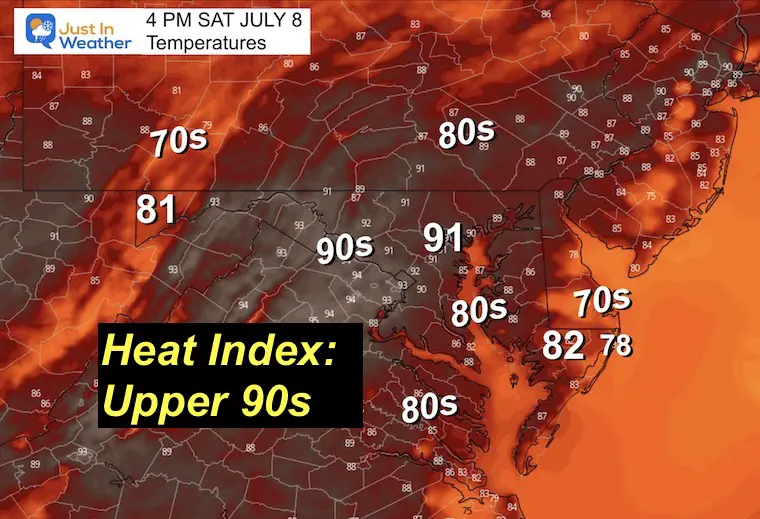
Afternoon Temperatures
The thermometers will reach the 90s and it will feel like the upper 90s.
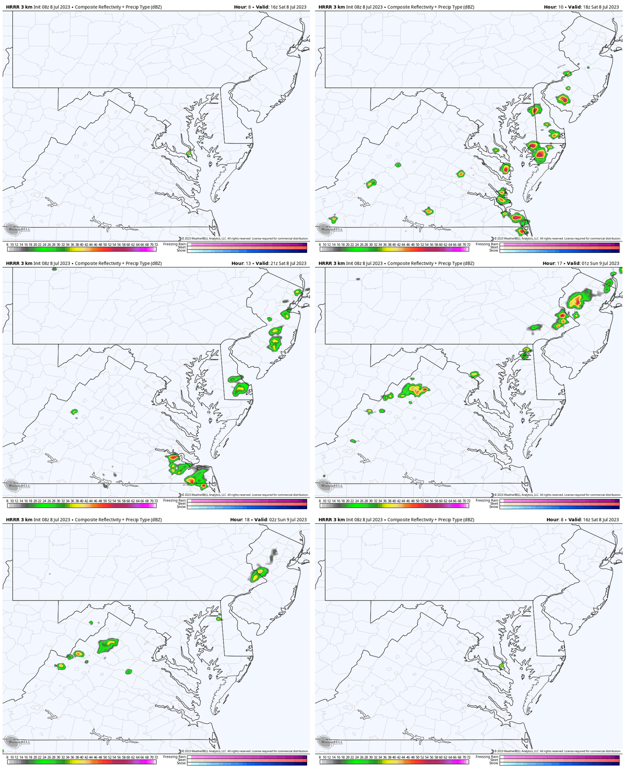
Radar Simulation Noon to 10 PM
This is a suggestion and NOT perfect.
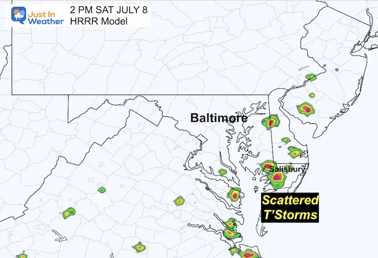
An afternoon cluster of thunderstorms may develop in Delmarva between Salisbury and central Delaware. This is dependent on where that cold front may be located.
2 PM – Suggestion
The higher chance for storms will be across Delmarva/Lower Eastern Shore near the Cold Front.
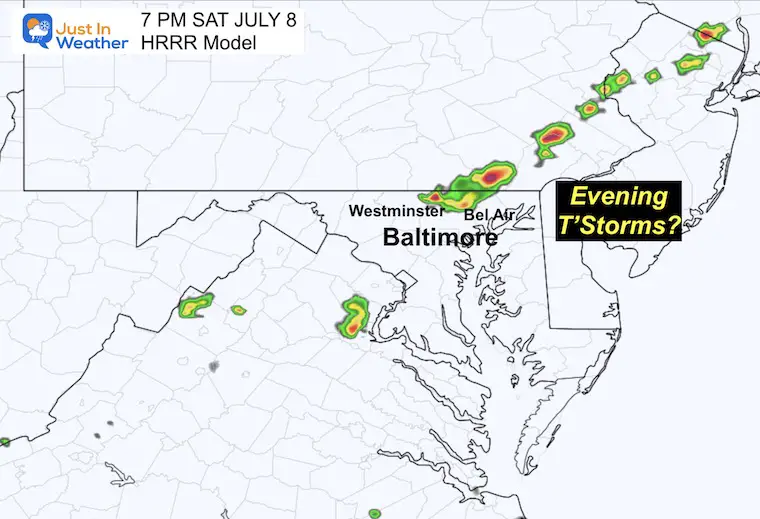
7 PM – Suggestion
There may be a new line of showers and storms trying to develop… I am cautious because this would be under the influence of a ‘ripple’ in the atmosphere behind the cold front and ahead of the approaching storm system. It is subtle and hard to pin down when it has not even formed yet.
EXPLORE MORE
2023 Hurricane Season Forecast With An El Niño Watch
Subscribe for eMail Alerts
Weather posts straight to your inbox
Sign up and be the first to know!
CLIMATE DATA
TODAY July 8
Normal Low in Baltimore: 68ºF
Record 53ºF in 2000
Normal High in Baltimore: 89ºF
Record 100ºF 2012
Sunday Weather
Morning Temperatures
I want to start by showing that most of the region will begin the day in the mid to upper 70s. This demonstrates how humid that air mass will be, which is a lot of energy to fuel strong to severe storms.
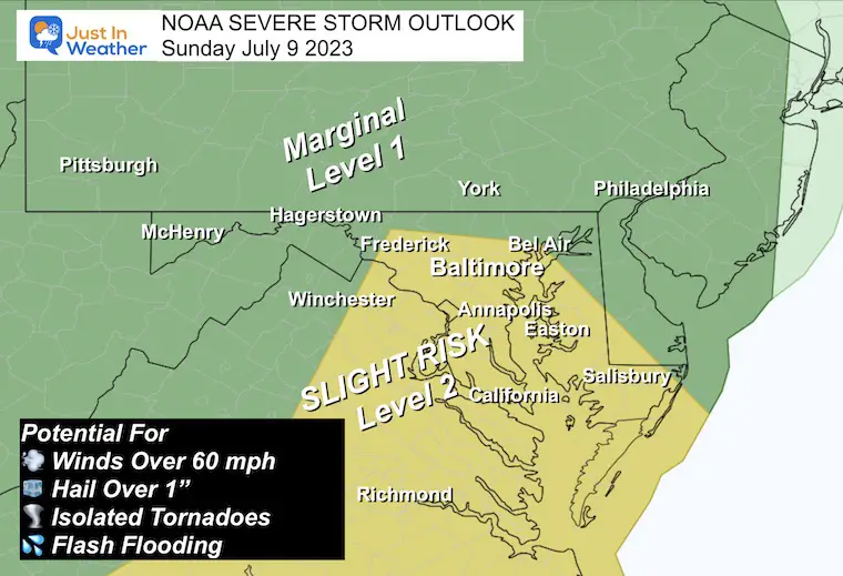
NOAA Severe Storm Risk
There may be showers in the morning, but the main event will be with the cold front later afternoon.
‘Slight Risk’ means a higher chance for storms to produce:
- Damaging winds over 60 mph
- Hail over 1 inch in diameter
- A few tornadoes
- Flash Flooding
Radar Simulation
NAM 3 Km Model 8 AM to 10 PM
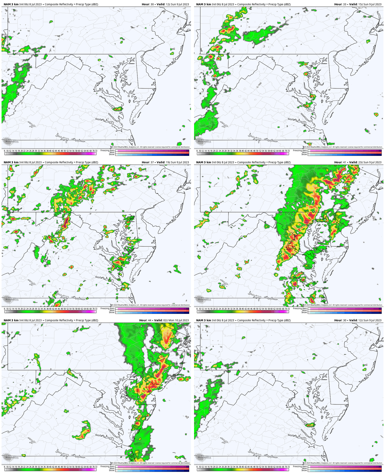
6 PM Snapshot
This is the rough timeframe we can expect the line of severe storms to cross into central Maryland. I have tried to repeat my point with each event that this is a guide and is not perfect. We will have a better handle on it by Sunday… but consider a window between 4 PM and 8 PM for the worst weather to erupt.
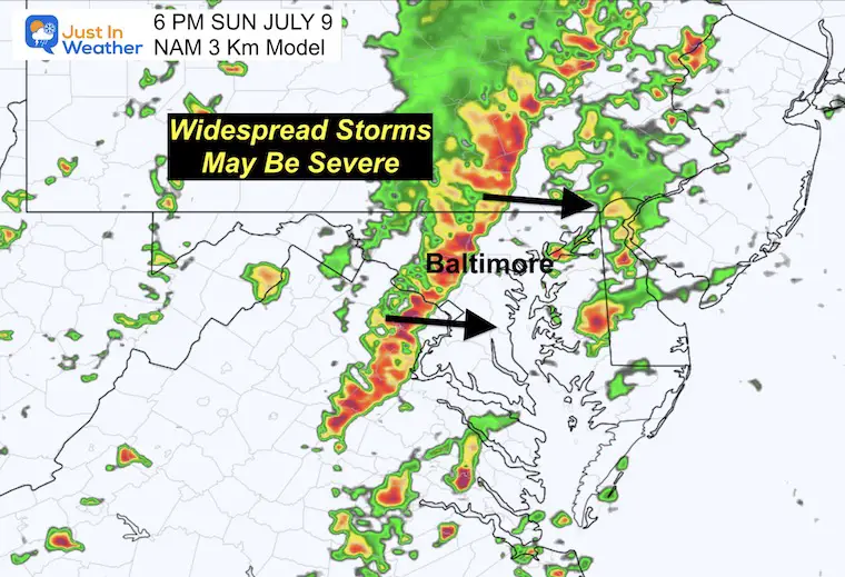
Temperatures
Check out the drop into the 60s under the rain-cooled air.
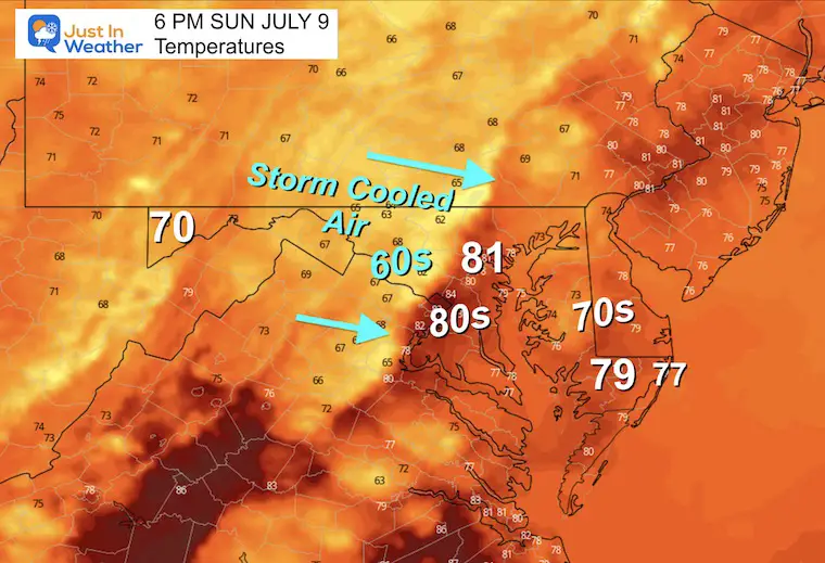
7 Day Forecast
This weather cycle will complete itself on Sunday with Severe Storms.
We begin the work week with a new air mass, but the heat will build quickly. Most of next week will be in the 90s, more humid and dry. The storm threat will return by the end of the week.
Subscribe for eMail Alerts
Weather posts straight to your inbox
Sign up and be the first to know!
EXPLORE MORE
2023 Hurricane Season Forecast With An El Niño Watch
La Niña Has Ended. El Niño May Return By Fall
Aurora Photos From Maryland, Delaware, and Virginia
Please share your thoughts, and best weather pics/videos, or just keep in touch via social media
-
Facebook: Justin Berk, Meteorologist
-
Twitter
-
Instagram
RESTATING MY MESSAGE ABOUT DYSLEXIA
I am aware there are some spelling and grammar typos and occasional other glitches. I take responsibility for my mistakes, and even the computer glitches I may miss. I have made a few public statements over the years, but if you are new here you may have missed it: I have dyslexia, and found out during my second year at Cornell University. It didn’t stop me from getting my meteorology degree, and being the first to get the AMS CBM in the Baltimore/Washington region. One of my professors told me that I had made it that far without knowing, and to not let it be a crutch going forward. That was Mark Wysocki and he was absolutely correct! I do miss my mistakes in my own proofreading. The autocorrect spell check on my computer sometimes does an injustice to make it worse. I also can make mistakes in forecasting. No one is perfect predicting the future. All of the maps and information are accurate. The ‘wordy’ stuff can get sticky. There has been no editor that can check my work when I needed it and have it ready to send out in a newsworthy timeline. Barbara Werner is a member of the web team that helps me maintain this site. She has taken it upon herself to edit typos, when she is able. That could be AFTER you read this. I accept this and perhaps proves what you read is really from me… It’s part of my charm.
#FITF


