June 29, 2023
Thursday Morning Update
This stinks! Literally! The smell of campfire was widespread yesterday, mixed with reports of burnt plastic. Either way, the haze grew thicker and became more irritating.
The irony of this summer is that when we get a cool air mass with a wind from the Northwest, the weather should be pleasant. That is also when we have been getting this smoke from wildfires in Canada and Michigan. At this point, we look for a warmer air mass to shift the winds for help. So heat and humidity will actually improve our air quality and we will get that this weekend.
From my personal perspective, I train outside all summer for The Maryland Trek (in August). I often push through marginal conditions, but yesterday I had to throw in the towel. I felt the irritation in my eyes and a friend who tried to bike told me he was having a bad headache. I will do the same and remain indoors today.
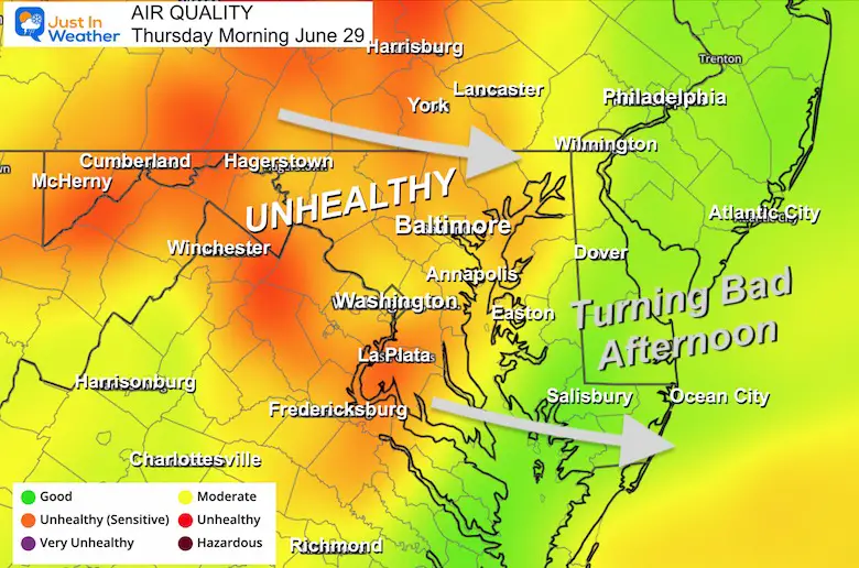
Morning Air Quality
The combination of cool air, ground moisture from recent rain, and particulates has led to areas of dirty fog. The better air quality across the Bay will deteriorate this afternoon as more smoke will arrive.
Air Quality Trends
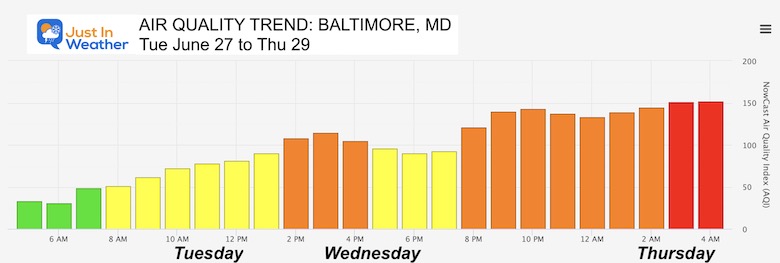
Here is a look at the measurements since Tuesday.
Baltimore, MD
The air is worse this morning and will be Code Red all day.
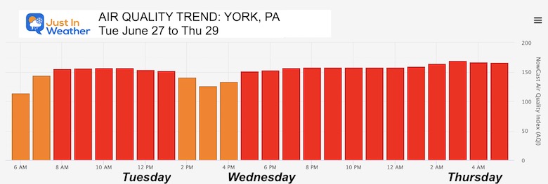
York, PA
The air has been worse in southern PA.
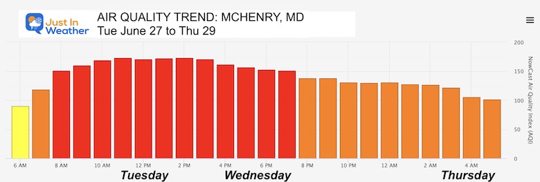
McHenry, MD
It’s been very bad in the mountains.
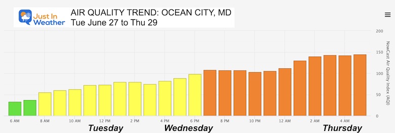
Ocean City, MD
The beaches have been gradually getting the smoke build in.
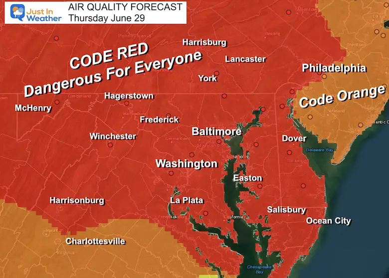
Forecast Today
Code Red For our entire Region!
This IS dangerous for all groups. This is why I am keeping my workout indoors.
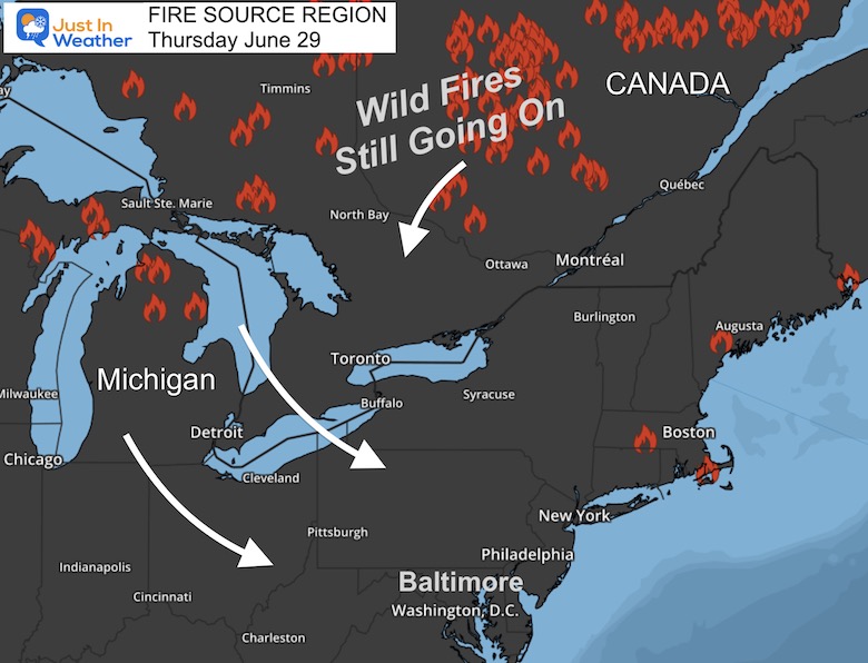
Smoke Source
I have heard people question the fires in Canada. I am NOT part of some conspiracy. What I have seen are the fire locations and the winds may have shifted to not affect places like Toronto or Quebec.
There have been wildfires in Michigan as well. That may be part of our main source now.
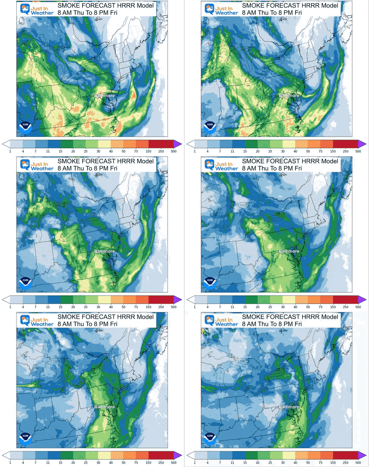
Smoke Forecast
Tuesday Morning To Friday Evening
The plume today will spread out and weaken tomorrow. The improvement in our air looks to arrive later Friday and into the weekend as we shift to winds from the South.
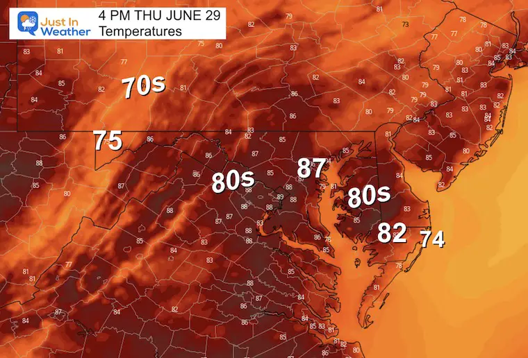
Afternoon Temperatures
These numbers are slightly below average WITH low humidity. It would be great IF we did not have the smoke.
EXPLORE MORE
June 27 Severe Storm Reports And Photos
2023 Hurricane Season Forecast With An El Niño Watch
Drought Watch Updated June 15
Subscribe for eMail Alerts
Weather posts straight to your inbox
Sign up and be the first to know!
CLIMATE DATA
TODAY June 29
Normal Low in Baltimore: 66ºF
Record 53ºF in 1974
Normal High in Baltimore: 88ºF
Record 105ºF 1934
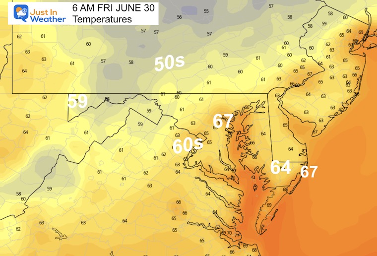
Friday Weather
Morning Temperatures
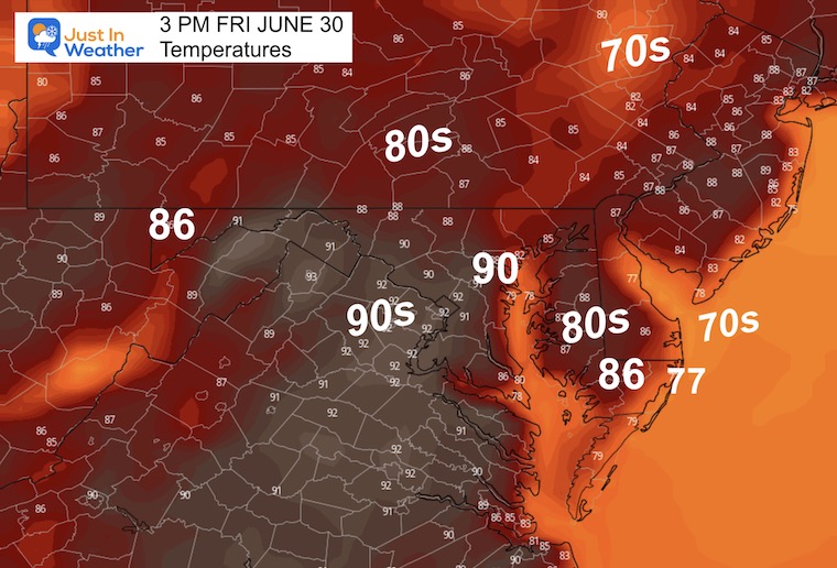
Afternoon Temperatures
The air quality may not be great, but we should start to see an improvement.
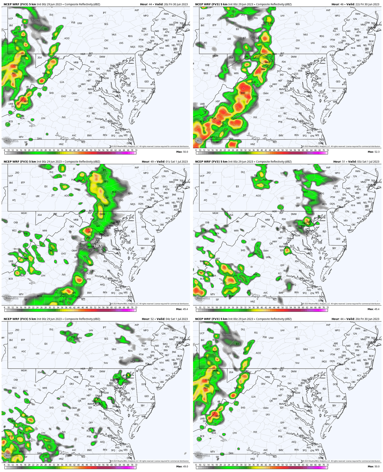
Evening Storms?
WRF Model Friday 4 PM to Midnight
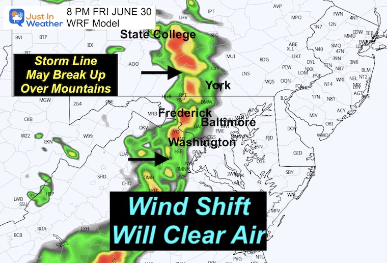
The reason for the improvement in the air will be the wind shift. A line of thunderstorms will form in the mountains and shift east. That will help stir up the atmosphere.
8 PM Snapshot
While the mountains will get rain, this line may break up east of Frederick. So this is not a promise central areas get wet.
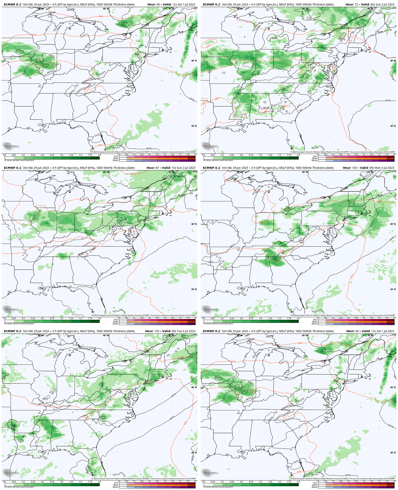
Rain Forecast Saturday to Monday
This weekend will be more humid and stormy, but there will be dry hours so it will not be a washout. The pulsing of storms each afternoon will last through Monday. As of now, July 4th may bring back a more stable and less stormy environment.
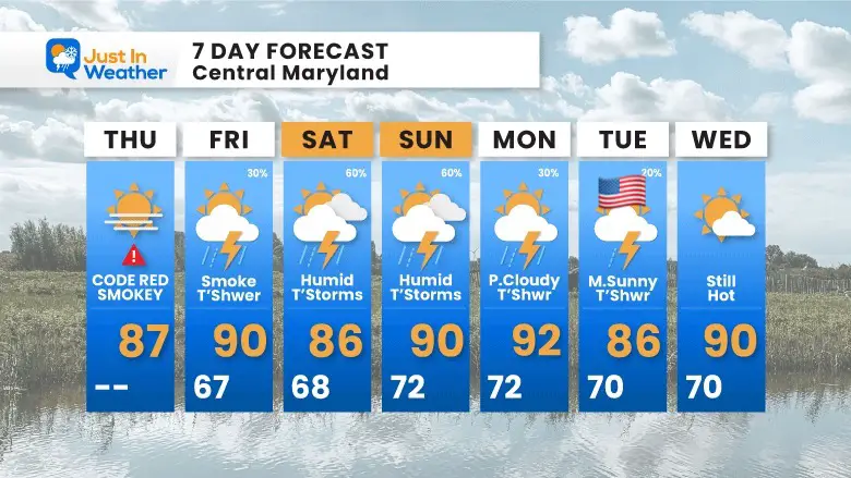
7 Day Forecast
We will trade the smoke for humidity and more heat into the weekend. This will bring afternoon showers and thunderstorms. These will not be washouts, however, if you have outdoor plans they may be affected. Simply have a plan to get indoors if there is lightning nearby each day.
Subscribe for eMail Alerts
Weather posts straight to your inbox
Sign up and be the first to know!
EXPLORE MORE
2023 Hurricane Season Forecast With An El Niño Watch
La Niña Has Ended. El Niño May Return By Fall
Aurora Photos From Maryland, Delaware, and Virginia
Please share your thoughts, and best weather pics/videos, or just keep in touch via social media
-
Facebook: Justin Berk, Meteorologist
-
Twitter
-
Instagram
RESTATING MY MESSAGE ABOUT DYSLEXIA
I am aware there are some spelling and grammar typos, and occasional other glitches. I take responsibility for my mistakes, and even the computer glitches I may miss. I have made a few public statements over the years, but if you are new here you may have missed it: I have dyslexia, and found out during my second year at Cornell University. It didn’t stop me from getting my meteorology degree, and being first to get the AMS CBM in the Baltimore/Washington region. One of my professors told me that I had made it that far without knowing, and to not let it be a crutch going forward. That was Mark Wysocki and he was absolutely correct! I do miss my mistakes in my own proofreading. The autocorrect spell check on my computer sometimes does an injustice to make it worse. I also can make mistakes in forecasting. No one is perfect predicting the future. All of the maps and information are accurate. The ‘wordy’ stuff can get sticky. There has been no editor that can check my work when I needed it and have it ready to send out in a newsworthy timeline. Barbara Werner is a member of the web team that helps me maintain this site. She has taken it upon herself to edit typos, when she is able. That could be AFTER you read this. I accept this and perhaps proves what you read is really from me… It’s part of my charm.
#FITF


