Severe Storm Reports June 27 Heavy Rain Hail Video And Cloud Photos
June 28, 2023
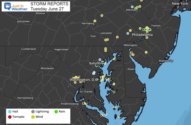
The culmination of a week of rain came with widespread severe weather in the Mid-Atlantic. It is ironic and yet somewhat common that we can get more storms on a day with marginal risk than when we have a higher risk from NOAA…. Like we did the day before.
A strong cold front moved through to spawn multiple storm cells. Our region is in a moderate and growing drought, and while some areas received over 6 inches of rainfall, most of the areas did not. So our drought watch will continue.
Storm Reports
The focus of the most intense storms was from Washington, DC along Rt. 50 to Grasonville with wind damage. Pockets of wind damage events were scattered across Southern Maryland and northeastern Maryland to metro Philadelphia.
On the edge of that storm, large hail fell over Anne Arundel County, about 10 to 20 miles Northwest of Annapolis.
A complete list of local storm reports from The National Weather Service in Sterling, VA is at the bottom of this post.
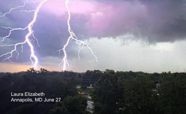
Lightning In Annapolis
Vivid and intense cloud to ground lightning along with loud thunder was very prominent in Anne Arundel County. It is important to note that the most dangerous lightning is before the first drop of rain. That is when many people are still outside, regardless of severe storms or not.
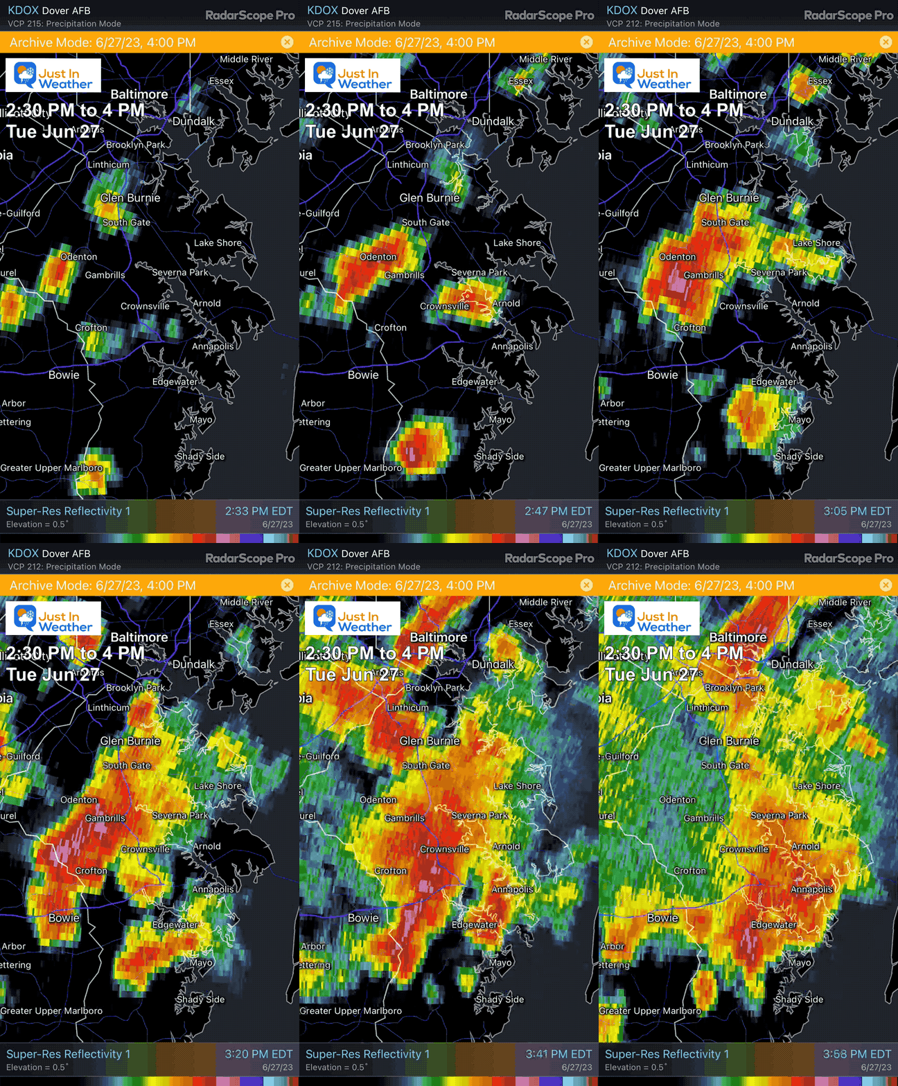
Radar Loop
Tuesday 2:30 PM to 4 PM
This shows the build up of the storm over Anne Arundel County, MD. The pink shade over Odenton, Gambrills, and Crofton between 2:45 to 3 PM was the peak of that cell… Then it expanded across I-97 and dumped heavy rain through the central Chesapeake Bay region.
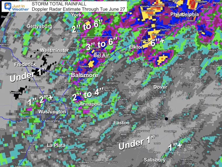
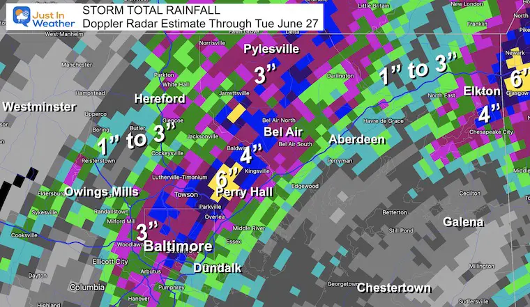
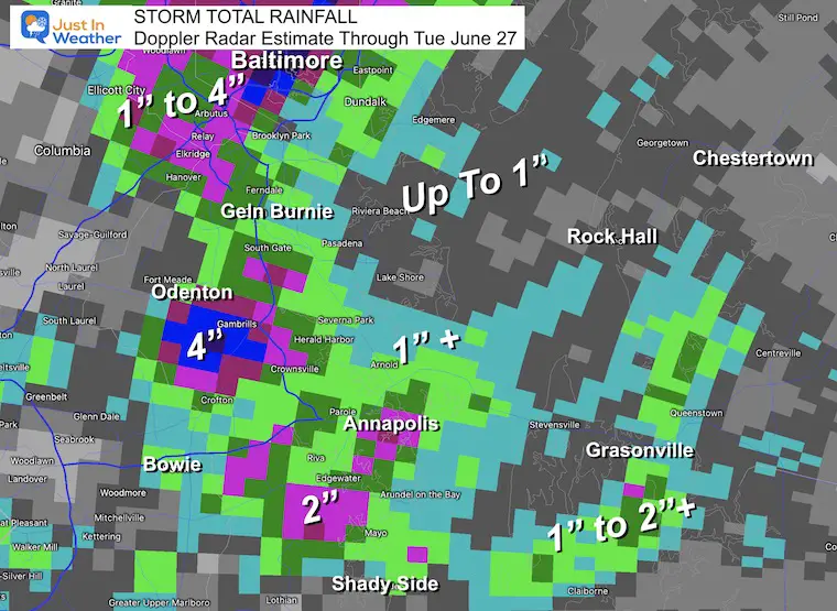
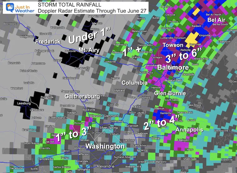
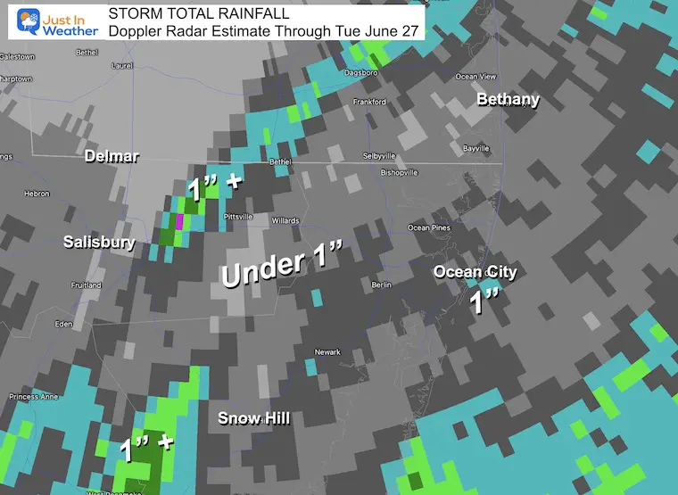
Below is a look at the rainfall estimates from Doppler Radar. I zoomed in on different areas to show how localized the heavy rain was measured.
Large Hail
For a storm to be considered severe, the hail is measured as larger than a quarter or one inch in diameter.
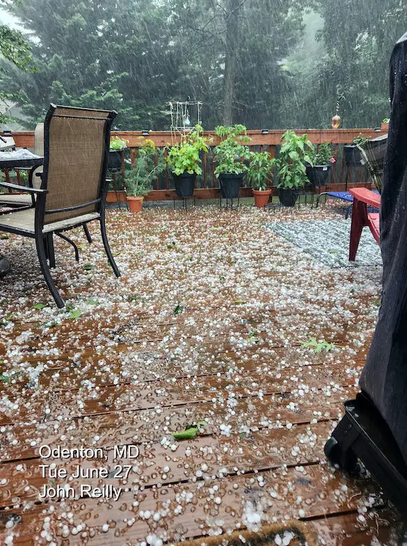
This storm over Odenton produced hail up to 1.5 inches.
John Reilly shared this coverage of hailstones on his deck.
RemasterDirector_18da6b0cf
Video:
I shared this on my Facebook page. The impression of how large these hail stones were can be seen splashing in the water. Thanks to Kati Bethuy for sharing this.
Rainfall Estimated By Doppler Radar
This wide view shows how local the pockets of heavy rain were. Notice the Yellow shade was over 6 inches north of Baltimore and between Elkton MD to Metro Philadelphia.
Local Views
Northern Maryland
Baltimore City had between 1.5 and 3 inches of rain. There was a pocket of 6 inches of rain around Perry Hall.
Baltimore’s BWI recorded 1.77 inches of rain, yet there is still a deficit of 7.46 inches for the year. So we are not out of the drought.
Central Maryland – South of Baltimore
We can see the pockets of heavy rain. That hail storm near Odenton and Crofton pulsed 3 to 4 inches of rain.
Annapolis got around 2 inches, with between 1 to 2 inches crossing Kent Island.
Central Maryland – West of Baltimore
There was a sharp cut-off west of the city. Carroll County is parched. While Eldersburg got around 1 inch of rain, much less to nearly nothing fell on Mount Airy up to Westminster.
Farther west around Frederick, they have missed many storms that have broken up or split around the mountains. The wind flow from the west will often result in that downslope or rain shadow effect.
Lower Eastern Shore
There were some pockets close to 1 inch of rain east of Salisbury and around Ocean City. Most of the area got under 1 inch.
Cool Clouds
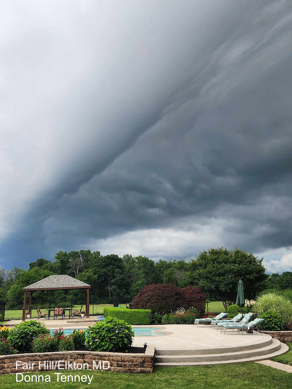
Shelf Cloud in Fair Hill/Elkton
This low cloud is common on the front edge of a strong to severe storm.
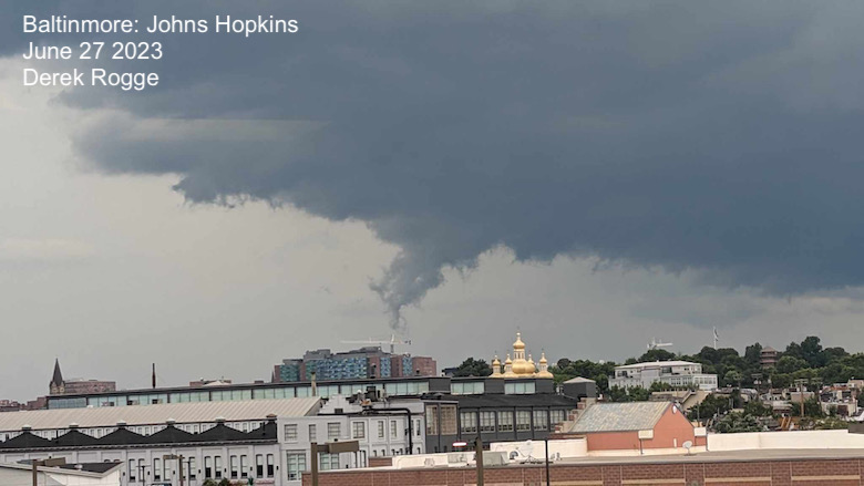
Scud Cloud over Baltimore
Derek Rogge said this dropped and then lifted. This is often thought to be a funnel cloud with a forming tornado. However, it is more likely a low-level condensation and non-violent event. This can form with high humidity and be moved and shaped by rising updrafts.
Scud stands for Scattered Cumulus Under Deck
Wall Cloud in Owings Mills
This low circulation did give some the impression there was a tornado, but that was not the case.
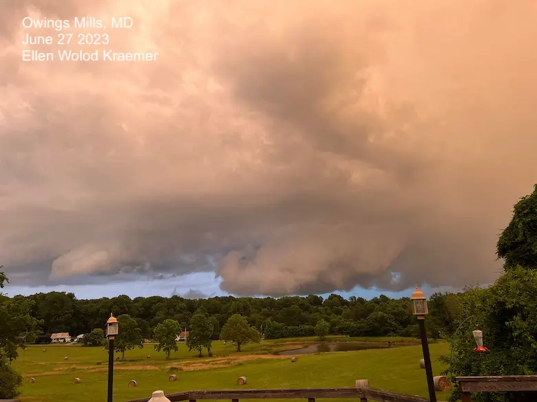
Was there a tornado trying to form?
Jacob Sprankel thought he spotted one from his drone over Columbia.
Was reviewing some drone footage and discovered a possible brief tornado touchdown just east of Columbia. What do you think? 🤔🌪️ #MDwx pic.twitter.com/EpPGYwamb0
— Jacob Sprankle (@J_Sprankle) June 27, 2023
Doppler Radar Velocity Scan
Tom Tasselmyer from WBAL (my former chief) posted this tweet with some support.
@TonyPannWBAL Here’s the storm relative velocity from BWI terminal doppler for the possible tornado in Columbia this afternoon. @NWS_BaltWash pic.twitter.com/cx9oiCbpgr
— Tom Tasselmyer (@ttasselWBAL) June 27, 2023
Storm Reports From The National Weather Service Office in Sterling, VA
Preliminary Local Storm Report...Summary
National Weather Service Baltimore MD/Washington DC
1039 AM EDT Wed Jun 28 2023

..TIME...   ...EVENT...      ...CITY LOCATION...     ...LAT.LON...
..DATE...   ....MAG....      ..COUNTY LOCATION..ST.. ...SOURCE....
            ..REMARKS..

0201 PM     Tstm Wnd Dmg     2 NNE Hickory           39.61N  76.33W
06/27/2023                   Harford            MD   911 Call Center

            A tree fell onto a gutter at a residence along Kathleen
            Drive in Fallston.

0211 PM     Tstm Wnd Dmg     3 SSW Reston            38.91N  77.36W
06/27/2023                   Fairfax            VA   Broadcast Media

            Trees blew down on VA-665 Fox Mill Road near
            Thoroughbred Road.

0212 PM     Tstm Wnd Dmg     1 S Reston              38.93N  77.35W
06/27/2023                   Fairfax            VA   Dept of Highways

            Trees blew down near the intersection of South Lakes
            Drive and Soapstone Drive.

0223 PM     Tstm Wnd Dmg     1 N Wolf Trap           38.95N  77.28W
06/27/2023                   Fairfax            VA   911 Call Center

            Trees blew down onto VA-675 Browns Mill Road near
            VA-702 Beulah Road, and near Windstone Drive.

0224 PM     Tstm Wnd Dmg     2 NE Wolf Trap          38.96N  77.26W
06/27/2023                   Fairfax            VA   Broadcast Media

            Trees and wires blew down blocking VA-676 Towlston Road
            near Dara Lane.

0225 PM     Tstm Wnd Dmg     Tysons Corner           38.92N  77.23W
06/27/2023                   Fairfax            VA   Broadcast Media

            The ramp from eastbound VA-7 Leesburg Pike to
            northbound VA-123 Chain Bridge Road was blocked by
            downed trees.

0227 PM     Tstm Wnd Dmg     2 NNE Tysons Corner     38.94N  77.22W
06/27/2023                   Fairfax            VA   Dept of Highways

            Trees blew down along VA-807 Old Falls Road.

0227 PM     Tstm Wnd Dmg     2 SW The American Legio 38.95N  77.21W
06/27/2023                   Fairfax            VA   Dept of Highways

            Trees blew down near the intersection of VA-685 Swinks
            Mill Road and VA-738 Old Dominion Drive.

0228 PM     Tstm Wnd Dmg     2 SSE Fairfax           38.83N  77.29W
06/27/2023                   Fairfax            VA   911 Call Center

            Trees blew down onto VA-620 Braddock Road near Burke
            Station Road.

0230 PM     Tstm Wnd Dmg     1 NNW Langley           38.96N  77.17W
06/27/2023                   Fairfax            VA   Dept of Highways

            Trees blew down on Heather Brook Court near Ridge
            Drive.

0234 PM     Tstm Wnd Dmg     1 WSW Barcroft          38.85N  77.12W
06/27/2023                   Fairfax            VA   911 Call Center

            Trees blew down on VA-7 Leesburg Pike near Carlin
            Springs Road.

0240 PM     Tstm Wnd Dmg     2 NW Scarboro           39.66N  76.33W
06/27/2023                   Harford            MD   911 Call Center

            Trees blew down near Street, near the intersection of
            Mill Green Road and MD-646 Prospect Road, and along
            MD-136 Whiteford Road.

0245 PM     Tstm Wnd Gst     Reagan National Arpt    38.85N  77.03W
06/27/2023  E39 mph          Arlington          VA   ASOS

            A thunderstorm produced an estimated wind gust to 34
            knots (39 MPH) near the ASOS at Ronald Reagan Washington
            National Airport (KDCA).

0305 PM     Hail             1 SW Odenton            39.05N  76.71W
06/27/2023  E0.88 inch       Anne Arundel       MD   Trained Spotter

0309 PM     Hail             1 SW Odenton            39.05N  76.71W
06/27/2023  M1.00 inch       Anne Arundel       MD   Trained Spotter

            Quarter size hail was reported in Piney Orchard near
            Odenton.

0310 PM     Hail             1 N Odenton             39.08N  76.69W
06/27/2023  M0.88 inch       Anne Arundel       MD   CoCoRaHS

            Nickel size hail was reported near Odenton.

0315 PM     Hail             1 SSW Odenton           39.05N  76.70W
06/27/2023  M1.25 inch       Anne Arundel       MD   Trained Spotter

            Half dollar size hail was reported in the 2600 block of
            April Dawn Way in Gambrills.

0325 PM     Tstm Wnd Dmg     Odenton                 39.06N  76.70W
06/27/2023                   Anne Arundel       MD   911 Call Center

            Trees blew down blocking a couple of roadways in
            Odenton.

0340 PM     Hail             1 N Fullerton           39.39N  76.51W
06/27/2023  M1.00 inch       Baltimore          MD   Trained Spotter

0342 PM     Tstm Wnd Gst     7 SSE Saint George Isla 38.01N  76.45W
06/27/2023  E39 mph          ANZ537             MD   Buoy

            A thunderstorm produced an estimated wind gust to 34
            knots (39 MPH) near one of the Lewisetta NOS sensors
            (LWTV2).

0349 PM     Tstm Wnd Gst     2 E Annapolis           38.97N  76.47W
06/27/2023  M41 mph          ANZ532             MD   Mesonet

            A wind gust of 36 knots (41 MPH) was measured by a
            personal weather station at Annapolis Sailing School
            (KMDANNAP2625).

0354 PM     Hail             3 SW Londontowne        38.90N  76.60W
06/27/2023  M1.00 inch       Anne Arundel       MD   CoCoRaHS

            Quarter size hail was reported in Birdsville.

0356 PM     Tstm Wnd Gst     2 SE Dahlgren           38.31N  77.03W
06/27/2023  E39 mph          ANZ536             VA   Buoy

            A thunderstorm produced an estimated wind gust to 34
            knots (39 MPH) near the Baber Point WeatherFlow sensor
            (XBAB).

0400 PM     Tstm Wnd Gst     2 ESE Eastport          38.96N  76.45W
06/27/2023  E39 mph          ANZ532             MD   Buoy

            A thunderstorm produced an estimated wind gust to 34
            knots (39 MPH) near the Annapolis CBIBS sensor (44063).

0400 PM     Tstm Wnd Gst     6 SE Cape St. Claire    38.99N  76.36W
06/27/2023  M44 mph          ANZ532             MD   Mesonet

            Wind gusts of up to 38 knots (44 MPH) were measured by
            a mesonet at WPL Pier 31 (MD068) between 4:00 and 4:25
            PM.

0401 PM     Tstm Wnd Gst     3 ESE Dahlgren          38.31N  77.00W
06/27/2023  M39 mph          ANZ536             VA   Buoy

            A wind gust of 34 knots (39 MPH) was measured by the
            Pylons Dahlgren WeatherFlow sensor (XPYL).

0405 PM     Tstm Wnd Gst     Swan Point              38.30N  76.94W
06/27/2023  M46 mph          ANZ536             MD   Buoy

            Wind gusts of up to 40 knots (46 MPH) were measured by
            the Cuckold Creek WeatherFlow sensor (XCCK).

0406 PM     Tstm Wnd Gst     1 E Eastport            38.97N  76.46W
06/27/2023  M44 mph          ANZ532             MD   Buoy

            Wind gusts of 38 knots (44 MPH) were measured by the
            Greenbury Point WeatherFlow sensor (XGBY) between 4:06
            and 4:11 PM.

0409 PM     Tstm Wnd Gst     1 E Bay Ridge           38.94N  76.44W
06/27/2023  E39 mph          ANZ532             MD   Buoy

            A thunderstorm produced an estimated wind gust to 34
            knots (39 MPH) near the Tolly Point WeatherFlow (XTOL).

0412 PM     Hail             Middle River            39.33N  76.43W
06/27/2023  M1.00 inch       Baltimore          MD   Trained Spotter

            Quarter size hail was reported in Middle River.

0413 PM     Tstm Wnd Gst     1 ESE Bowleys Quarters  39.30N  76.36W
06/27/2023  M41 mph          ANZ531             MD   Buoy

            A wind gust of 36 knots (41 MPH) was measured by the
            Seneca Creek WeatherFlow sensor (XSNC).

0415 PM     Tstm Wnd Gst     Saunders Point Light    38.88N  76.48W
06/27/2023  E51 mph          ANZ532             MD   Buoy

            Wind gusts of up to 47 knots (54 MPH) were measured by
            the Saunders Point Light WeatherFlow sensor (XMTR)
            between 4:15 and 4:25 PM.

0420 PM     Tstm Wnd Gst     1 S Highland Beach      38.91N  76.47W
06/27/2023  M41 mph          Anne Arundel       MD   Mesonet

            A wind gust of 36 knots (41 MPH) was measured by a
            Tempest station on Thomas Point Road adjacent to the
            Chesapeake Bay.

0420 PM     Flood            1 NNW Highlandtown      39.30N  76.55W
06/27/2023                   Baltimore City     MD   Fire Dept/Rescue

            A vehicle stalled in standing water on US-40 Pulaski
            Highway near East Monument Street.

0420 PM     Flood            2 N Brooklyn Park       39.24N  76.61W
06/27/2023                   Baltimore City     MD   Fire Dept/Rescue

            A vehicle stalled in standing water on MD-173 West
            Patapsco Avenue near MD-2 Potee Street.

0422 PM     Tstm Wnd Gst     3 SE Highland Beach     38.90N  76.44W
06/27/2023  M52 mph          ANZ532             MD   Buoy

            A wind gust of 45 knots (52 MPH) was measured by the
            Thomas Point NOS sensor (TPLM2).

0429 PM     Tstm Wnd Gst     8 ESE Bay Ridge         38.91N  76.31W
06/27/2023  E39 mph          ANZ540             MD   Mesonet

            A thunderstorm produced estimated wind gusts to 34
            knots (39 MPH) near a personal weather station at Goose
            Point (KMDSTEVE82) between 4:29 and 4:49 PM.

0444 PM     Tstm Wnd Gst     7 SE Aberdeen Proving G 39.40N  76.04W
06/27/2023  E39 mph          ANZ530             MD   Buoy

            A thunderstorm produced an estimated wind gust to 34
            knots (39 MPH) near the Grove Point WeatherFlow sensor
            (XGVP).

0448 PM     Tstm Wnd Gst     13 SE Fishing Creek     38.22N  76.04W
06/27/2023  M43 mph          ANZ543             MD   Buoy

            A wind gust of 37 knots (43 MPH) was measured by the
            Bishops Head Pier NOS sensor (BISM2).

0500 PM     Flood            2 E Baltimore           39.30N  76.58W
06/27/2023                   Baltimore City     MD   911 Call Center

            North Lakewood Avenue was closed due to flooding in the
            700 block, and near McElderry Street.

0500 PM     Flood            2 N Brooklyn Park       39.25N  76.61W
06/27/2023                   Baltimore City     MD   911 Call Center

            South Hanover Street was closed due to flooding near
            Reedbird Avenue.

0505 PM     Tstm Wnd Gst     14 E Bay Ridge          38.92N  76.21W
06/27/2023  M44 mph          ANZ540             MD   Mesonet

            Wind gusts of up to 38 knots (44 MPH) were measured by
            a mesonet in Grasonville (EW5728) adjacent to Eastern
            Bay between 5:05 and 5:10 PM.

0530 PM     Tstm Wnd Gst     7 SSE Saint George Isla 38.01N  76.45W
06/27/2023  M39 mph          ANZ537             MD   Buoy

            A wind gust of 34 knots (39 MPH) was measured by one of
            the Lewisetta NOS sensors (LWTV2).

0544 PM     Tstm Wnd Gst     23 NE Cove Point        38.59N  76.06W
06/27/2023  E39 mph          ANZ541             MD   Mesonet

            A thunderstorm produced an estimated wind gust to 34
            knots (39 MPH) near a mesonet on the US-50 Choptank
            River Bridge (MD004).

0544 PM     Tstm Wnd Gst     Point Lookout           38.04N  76.32W
06/27/2023  M41 mph          ANZ537             MD   Buoy

            Wind gusts of up to 36 knots (41 MPH) were measured by
            the Point Lookout WeatherFlow sensor (XPTL) between 5:44
            and 5:54 PM.

0646 PM     Tstm Wnd Gst     8 E Smith Island        37.97N  75.88W
06/27/2023  M46 mph          ANZ543             MD   Buoy

            Wind gusts of up to 40 knots (46 MPH) were measured by
            the Crisfield WeatherFlow sensor (XCRS) between 6:46 and
            6:59 PM.
Subscribe for eMail Alerts
Weather posts straight to your inbox
Sign up and be the first to know!
EXPLORE MORE
2023 Hurricane Season Forecast With An El Niño Watch
La Niña Has Ended. El Niño May Return By Fall
Aurora Photos From Maryland, Delaware, and Virginia
Please share your thoughts, and best weather pics/videos, or just keep in touch via social media
-
Facebook: Justin Berk, Meteorologist
-
Twitter
-
Instagram
RESTATING MY MESSAGE ABOUT DYSLEXIA
I am aware there are some spelling and grammar typos, and occasional other glitches. I take responsibility for my mistakes, and even the computer glitches I may miss. I have made a few public statements over the years, but if you are new here you may have missed it: I have dyslexia, and found out during my second year at Cornell University. It didn’t stop me from getting my meteorology degree, and being first to get the AMS CBM in the Baltimore/Washington region. One of my professors told me that I had made it that far without knowing, and to not let it be a crutch going forward. That was Mark Wysocki and he was absolutely correct! I do miss my mistakes in my own proofreading. The autocorrect spell check on my computer sometimes does an injustice to make it worse. I also can make mistakes in forecasting. No one is perfect predicting the future. All of the maps and information are accurate. The ‘wordy’ stuff can get sticky. There has been no editor that can check my work when I needed it and have it ready to send out in a newsworthy timeline. Barbara Werner is a member of the web team that helps me maintain this site. She has taken it upon herself to edit typos, when she is able. That could be AFTER you read this. I accept this and perhaps proves what you read is really from me… It’s part of my charm.
#FITF


