June 19 Air Quality Alert Today Then A Welcome Rainy Pattern Develops
June 19, 2023
Monday Morning Update
If you are off work for the Juneteenth federal holiday, we will continue with the heat from Father’s Day. However, we are building pollution, and a Code Orange Air Quality Alert has been issued for much of our region. So you may want to limit your outdoor exercise to before 10 or 11 AM.
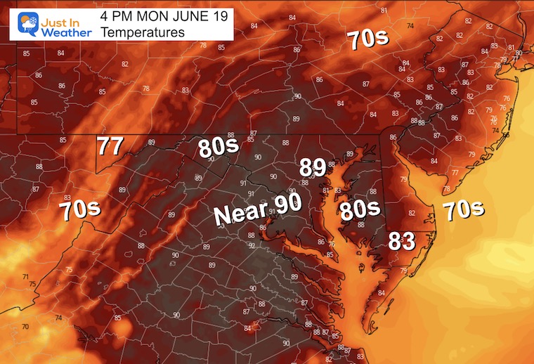
We need rain! That is an understatement and we may dent our drought this week. The initial changing weather pattern that seemed to fall apart, is coming back into focus. A larger air circulation is expected to bring in rain for the region with increasing odds from Wednesday through Saturday. Check it out:
Morning Surface Weather
Today will bring summer heat, which will then be replaced by a cooler pattern as winds will shift. This is due to High Pressure to our north working in conjunction with Low Pressure in the Southeast US. That is why we are bringing rain back to the ‘likely’ range for later this week.
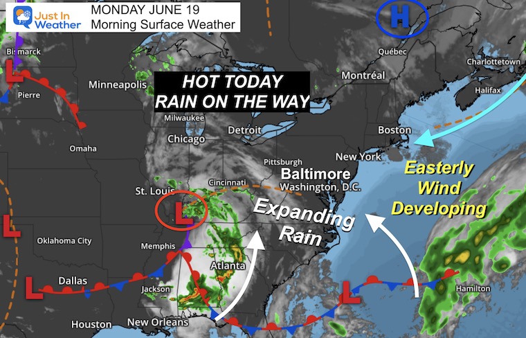
Air Quality Alert: Code Orange
The pollution levels will be building across most of our region today. This will affect sensitive groups and it is encouraged to limit outdoor activities to before 11 AM, or after 6 PM.
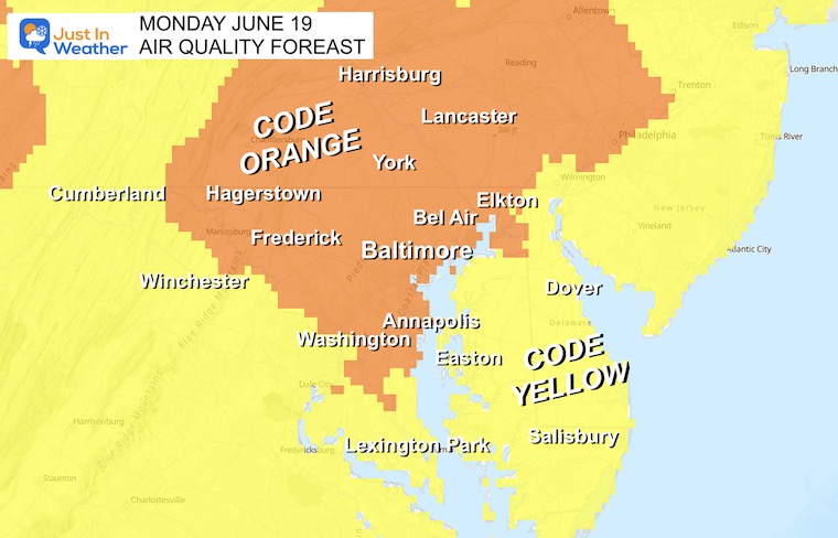
4 PM Temperatures
This will be our last day with summer heat for a while.
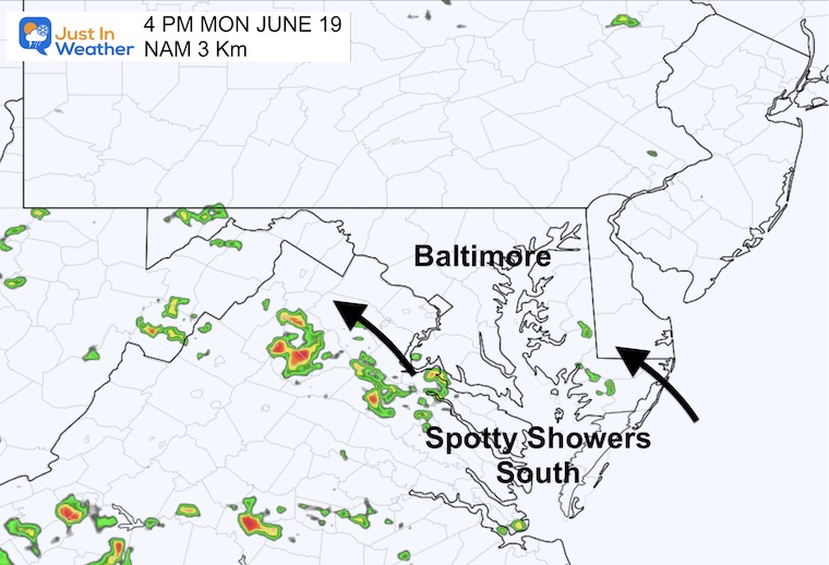
Rain Risk
There may be spotty showers to the south, more likely in central Virginia.
EXPLORE MORE
Drought Watch Updated June 15
2023 Hurricane Season Forecast With An El Niño Watch
Subscribe for eMail Alerts
Weather posts straight to your inbox
Sign up and be the first to know!
CLIMATE DATA
TODAY June 19
Normal Low in Baltimore: 64ºF
Record 48ºF in 1954
Normal High in Baltimore: 86ºF
Record 99ºF 1994
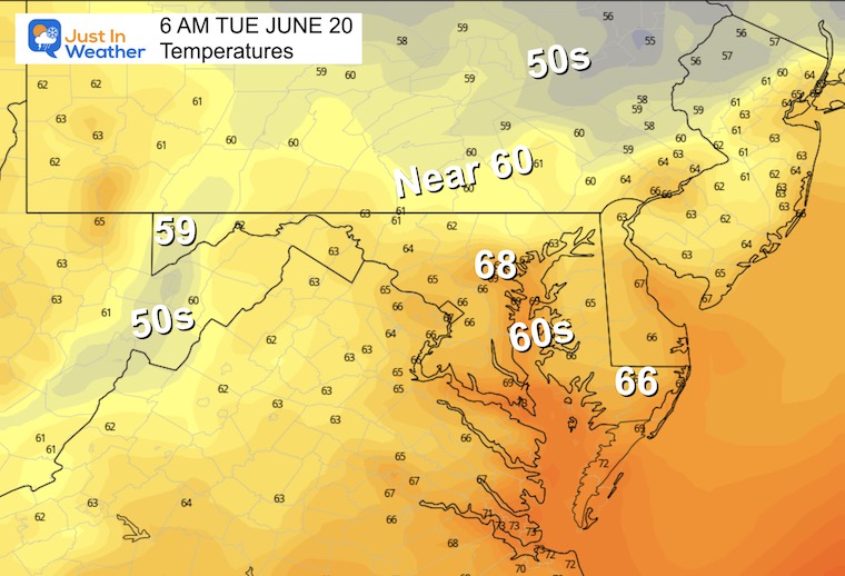
Tuesday
Morning Temperatures
Warm and humid.
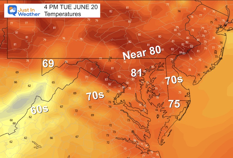
Afternoon Temperatures
With the wind direction changing, temps will be cooler. We expect more cloud cover and humidity ahead of the new weather pattern.
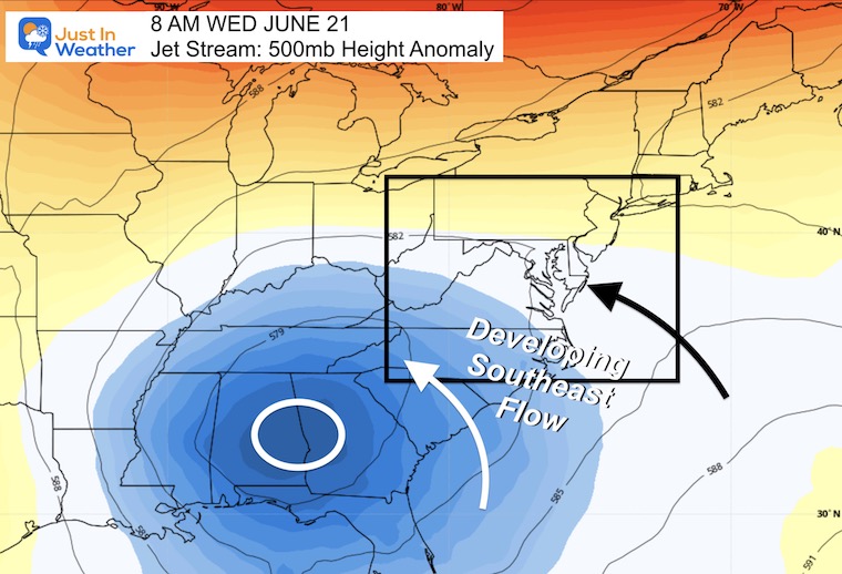
Jet Stream Wednesday
The Upper-Level Pattern will be run by a rare closed Low in the Southeast US. This will dominate the warm flow and help to expand rain into the Mid-Atlantic for the second half of the week.
Rain Forecast Snapshots
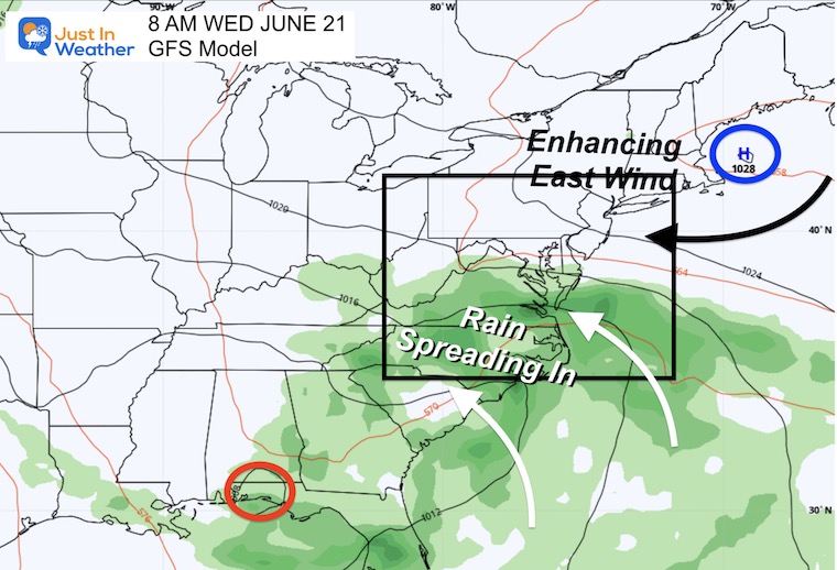
8 AM Wednesday
With the interaction of Low Pressure in western Florida and High Pressure east of Boston, the larger airflow will expand from the east and southeast. This is why the rain will expand our way.
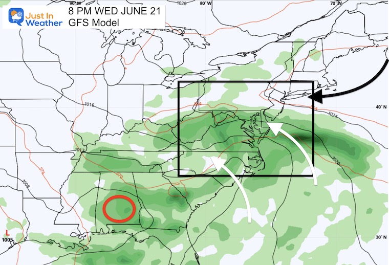
8 PM Wednesday
At this time, steady rain may expand from the south during the day and evening. Once this moves in, it may stay here for a few days.
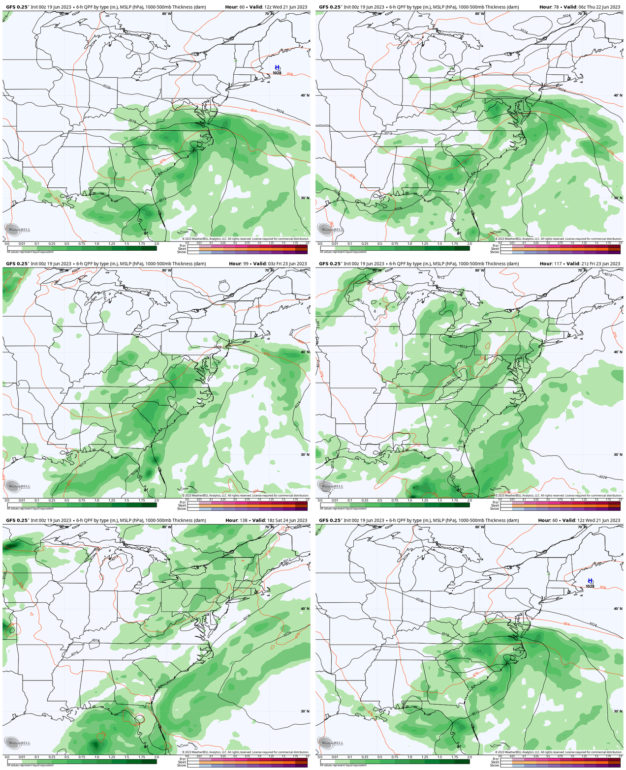
Rain Forecast Animation: GFS Model
Wednesday Through Saturday
We need rain and this may bring some beneficial water over a few days. The larger circulation will pump in moisture with a steady east-to-southeast airflow. While we expect the most active times to be in the afternoon and evenings, we will have to watch subtle disturbances to determine overall rain times each day.
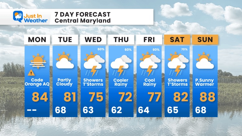
7 Day Forecast
One summer-like day, then as summer arrives this week, we get into a cooler wet pattern. At this point, the chance for rain will be building from Wednesday through Saturday. I have seen some models trying to keep our temps in the 60s on Thursday, but I am hedging my call for now. Still, at least 10 degrees below average temps are expected then.
We may break the pattern and warm up by Sunday.
Subscribe for eMail Alerts
Weather posts straight to your inbox
Sign up and be the first to know!
Also See:
La Niña Has Ended. El Niño May Return By Fall
Aurora Photos From Maryland, Delaware, and Virginia
Please share your thoughts, and best weather pics/videos, or just keep in touch via social media
-
Facebook: Justin Berk, Meteorologist
-
Twitter
-
Instagram
RESTATING MY MESSAGE ABOUT DYSLEXIA
I am aware there are some spelling and grammar typos, and occasional other glitches. I take responsibility for my mistakes, and even the computer glitches I may miss. I have made a few public statements over the years, but if you are new here you may have missed it: I have dyslexia, and found out during my second year at Cornell University. It didn’t stop me from getting my meteorology degree, and being first to get the AMS CBM in the Baltimore/Washington region. One of my professors told me that I had made it that far without knowing, and to not let it be a crutch going forward. That was Mark Wysocki and he was absolutely correct! I do miss my mistakes in my own proofreading. The autocorrect spell check on my computer sometimes does an injustice to make it worse. I also can make mistakes in forecasting. No one is perfect predicting the future. All of the maps and information are accurate. The ‘wordy’ stuff can get sticky. There has been no editor that can check my work when I needed it and have it ready to send out in a newsworthy timeline. Barbara Werner is a member of the web team that helps me maintain this site. She has taken it upon herself to edit typos, when she is able. That could be AFTER you read this. I accept this and perhaps proves what you read is really from me… It’s part of my charm.
#FITF


