


May 19 Weather Sunday Starts Foggy The Warming With Sun And Summer Heat On The Way
Sunday May 19 Morning Report The aftermath of the rainy Saturday is plenty of leftover moisture. This has left us with a bit of humidity and areas of thick fog…
May 3, 2023
Wednesday Mid-Day Update
I get it! It’s May and not the right time to have Faith in the Flakes. After shivering at baseball practice yesterday, I hear you! I just want to point out this rare event in case you see something that isn’t rain and you won’t be too surprised.
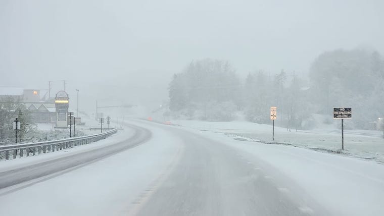
The frozen stuff I mention is NOT the snow I’ve been showing from western Maryland or West Virginia. I do not expect stickage. However, in the showers and squalls that are developing in this unstable atmosphere, something else could mix in across the colder inland Maryland suburbs, mountains, and southern Pennsylvania.
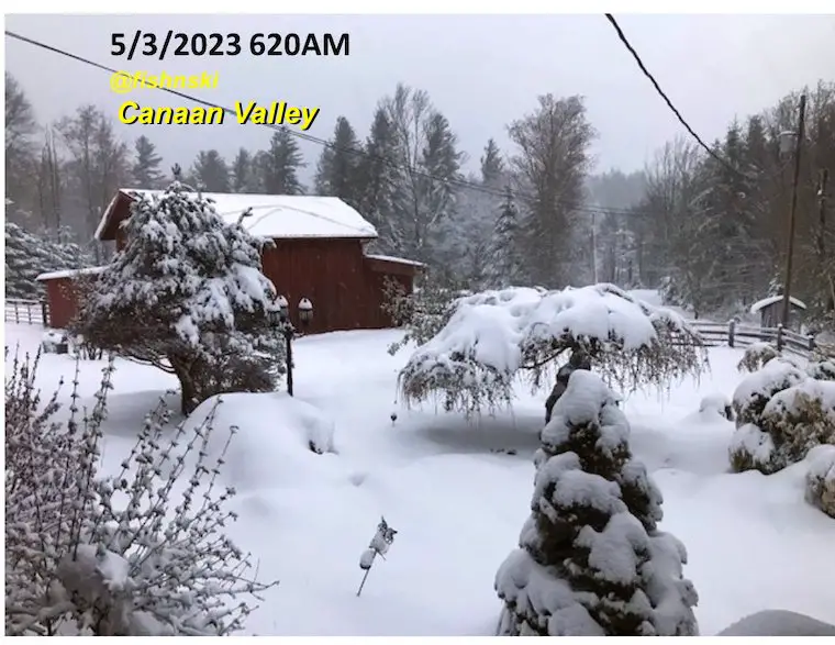
@fishnski reported 17 inches of snow at 3,800 Ft in Canaan Valley this morning. There was more that fell and melted and much more at the summit around 4,500 Ft.
Frozen Precipitation Types: Let’s break them down
From Allegheny Mountains Weather
Note that the lake itself may warm the surrounding areas, but you may see snow stick on the slopes of Wisp.
This webcam is positioned at The Greene Turtle Deep Creek Lake and shows Wisp Resort, including a zoomed-in view of Squirrel Cage, The Face, the terrain park, Boulder, the mountain coaster, the tubing park and a shot of McHenry Cove at Deep Creek Lake!
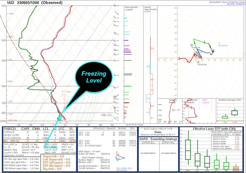
This product is the result of a weather balloon launch this morning from Sterling, VA. A package of weather instruments documents conditions as the balloon rises. There are entire courses that are taught about this and how we use it.
For now, I’ve highlighted the identified Freezing Level above our region at 3,569 Ft above the ground!
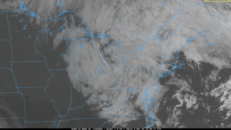
We can see the rotation of clouds around the Low Pressure. The unstable air will build up more clouds and low level convection/possible thundershowers or squalls into the afternoon.
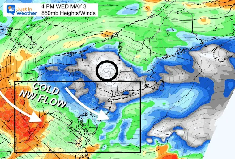
This HRRR Model is set at 850mb Level. That is around 5,000 Ft and in the clouds to show how they are likely to be directed.
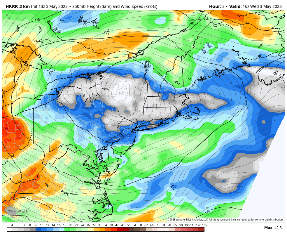
I picked mid afternoon as a base to highlight a few conditions. This shows the Upper Low and the wind flow. Clouds and showers will be moving along these lines and quickly.
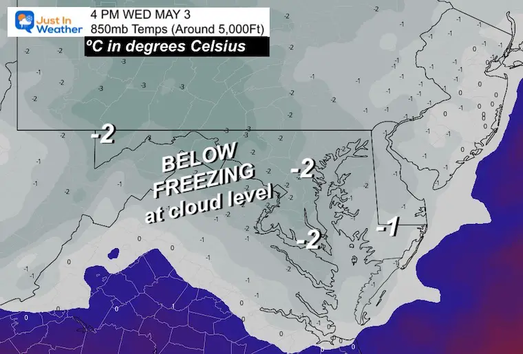
This is at the same altitude around 5,000 Ft. The numbers are in Celsius and show the region uniformly BELOW FREEZING.
This means that in the clouds there may very well be snowflakes, or depending on the vertical movement, a mix of sleet, graupel or small hail.
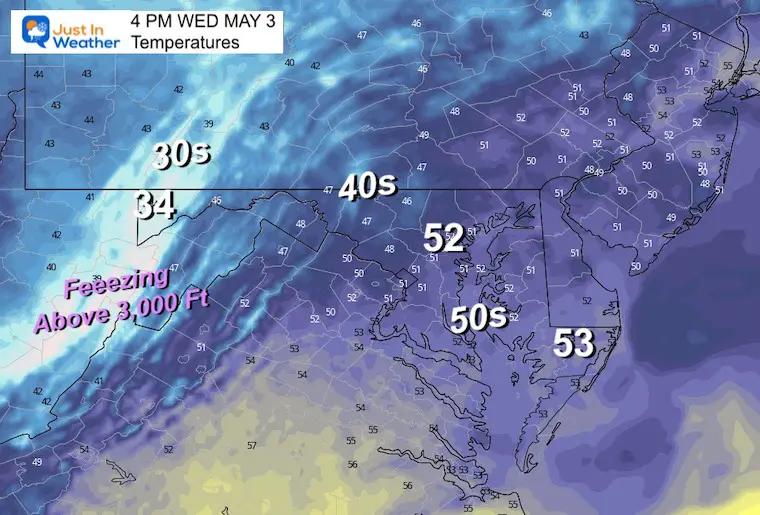
We will be chilly, but safely above freezing. In metro Baltimore, the lower 50s will likely melt most if not all of what falls.
However, the inland suburbs in the 40s and higher in elevation could get some mixed precipitation falling. A splatter of a slushy snowflake or bounce of a sleet pellet, graupel, or small hail is possible.
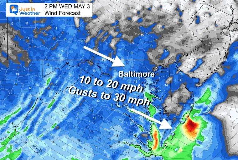
The westerly wind will continue at an average of 10 to 20 mph. A few gusts may push up close to 30 mph again. This may be locally higher with stronger squalls.
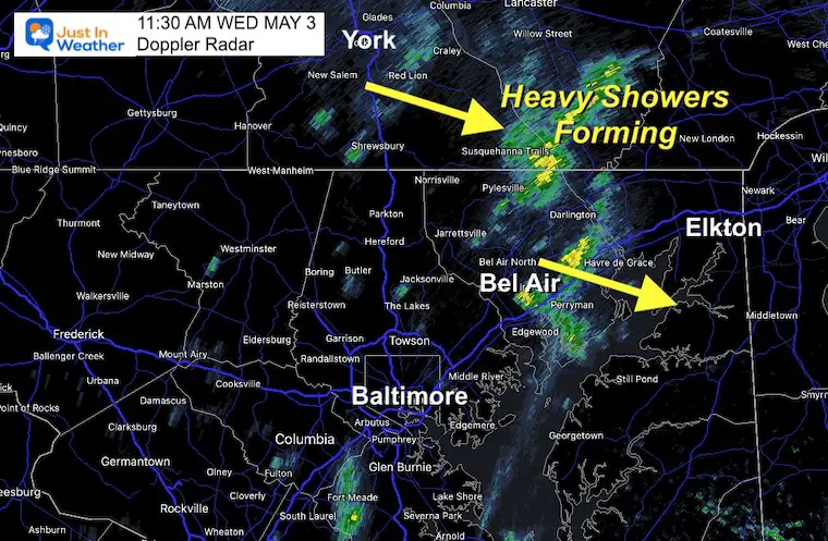
The morning radar snapshot shows some small intense cells popping already.
Below is the Live Radar Widget and Simulation to compare.
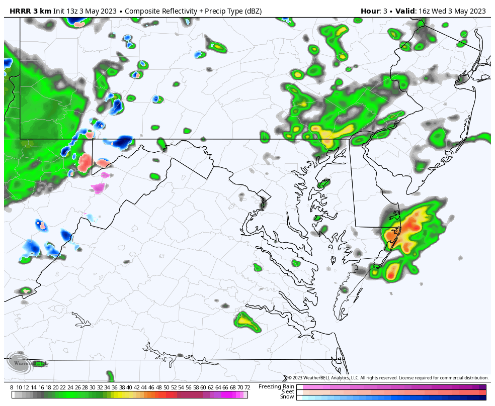
This HRRR Model is NOT perfect, but gives an idea of the spotty flare up of showers and some intense cells during the afternoon, and settling down this evening.
The blue shows the snow in the mountings. I have the Deep Creek Lake Live Cam below if you want to see it.
This will NOT show frozen precipitation, but it will highlight intensity with brighter colors. Also any lighting if it sparks.
The @fishnski was in reply to Tony Pann’s morning Tweet. We have the same idea on this afternoon.
17 inches have stuck measured at 3800′ Canaan Valley…much more has fallen but melted some during the day..it’s May!…but above 4500′ it’s DEEP….still snowing…. pic.twitter.com/B836NJYDNt
— fishnski (@fishnski1) May 3, 2023
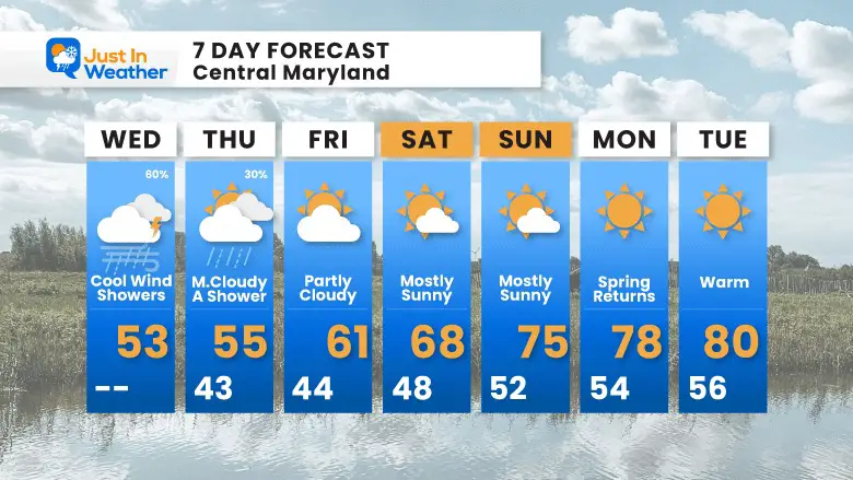
We will shake this damp and chilly air. We should break the weekend streak as this Saturday and Sunday look much better with sunshine and warmer temperatures. Finally, we get back to spring and approach 80ºF next week.

Click to see more and ‘Book’ a visit to your school

I am aware there are some spelling and grammar typos, and occasional other glitches. I take responsibility for my mistakes, and even the computer glitches I may miss. I have made a few public statements over the years, but if you are new here you may have missed it: I have dyslexia, and found out during my second year at Cornell University. It didn’t stop me from getting my meteorology degree, and being first to get the AMS CBM in the Baltimore/Washington region. One of my professors told me that I had made it that far without knowing, and to not let it be a crutch going forward. That was Mark Wysocki and he was absolutely correct! I do miss my mistakes in my own proofreading. The autocorrect spell check on my computer sometimes does an injustice to make it worse. I also can make mistakes in forecasting. No one is perfect predicting the future. All of the maps and information are accurate. The ‘wordy’ stuff can get sticky. There has been no editor that can check my work when I needed it and have it ready to send out in a newsworthy timeline. Barbara Werner is a member of the web team that helps me maintain this site. She has taken it upon herself to edit typos, when she is able. That could be AFTER you read this. I accept this and perhaps proves what you read is really from me… It’s part of my charm.
#FITF