Slushy Super Bowl Sunday Evening Still Possible
February 8, 2023
Wednesday Afternoon Update
I am probably going to keep asking this for the rest of the week: Please keep an open mind for the weekend weather. We are in a warm weather pattern, and it will be warm next week. In between, there will be an event I am calling ‘the blip’. It is an upper-level Low that will help generate a small coastal storm on Sunday.
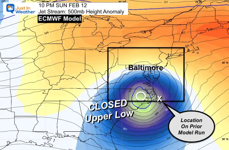
Jet Stream Sunday Night
This map shows the European ECMWF Model. I have highlighted the core of the Closed Low compared to where this same model plotted it just 12 hours ago. The latest run is slower and a little farther north.
Dynamic Cooling
This is a term you may hear about through this weekend. The location of that Upper Level Low is very important as it will help the storm generate its own cold air. This will happen under the cold pocket aloft by both enhancing precipitation AND that precipitation drawing colder air down to the surface.
In cases like this, rain can change to snow, where it is heavier! Then back to rain as it lightens up.
The dynamic cooling is during the process of forming heavy pockets of precipitation.
The specifics of this weather system may not be picked up on your local weather app, and the computer guidance has been inconsistent. But we saw this last week, right? If you remember, I had questioned the arctic front being too far south. It ended up verifying North and closer to us. The result was the minor snow event that broke the snowless streak in Baltimore.
Last night and this morning, I showed that the modeling finally made that return shift back north. I think there is a little more adjustment to go. That is why I believe it is worth paying close attention to.
There are three reasons I have been focused on this system:
- I still expect there will be adjustments north. That would change the snow region.
- It is potential ‘slushy’ snow in a warm week. Temps will remain above freezing in metro areas, but snow bursts can overtake the warmer ground and pavement when falling at night.
- The timing is on Super Bowl Sunday. So it may affect travel to or from parties.
Important Note: I’ve seen the model bias for years that tend show a storm that ends up farther north or west. So while I show new model plotted maps, they are not the final solution.
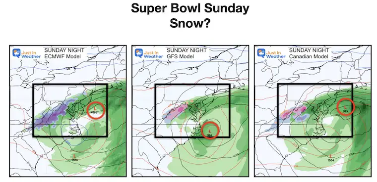
Three Model Comparisons
The trade off continues as the European has taken back the lead for colder and more snow for central (inland) Maryland. More likely west and north of Baltimore.
The GFS and Canadian GEM both have that wintry mix inland.
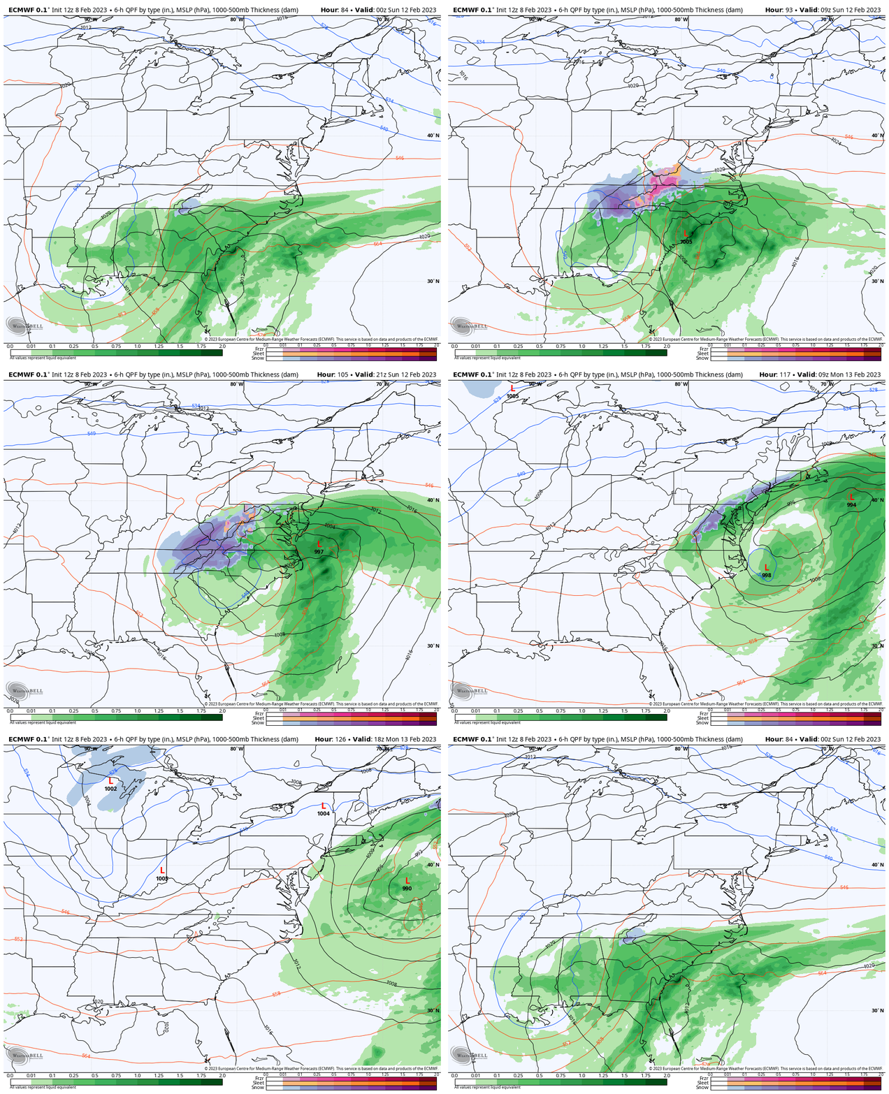
European ECMWF Model Animation
Saturday Night To Monday Afternoon
Watch how the cold air generates snow (blue) as it rolls up the coast and intensifies. Just like that ocean blizzard I showed yesterday, I believe this may end up stronger than the computer guidance we are seeing now.
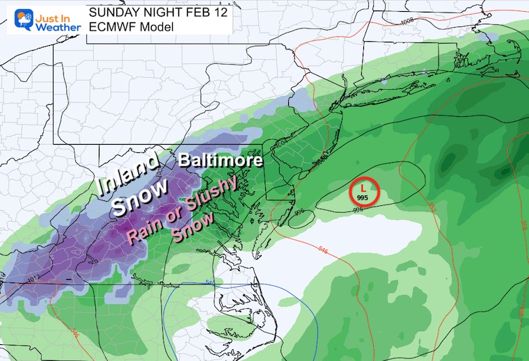
Mid Atlantic Close Up
Sunday Night 7 PM to 1 AM Monday
I chose this because of the summary of the evening, when Super Bowl parties will be ending and people will be driving home.
Any stronger intensity will expand the coverage of snow.
Any shift in the upper low North will expand the snow coverage in central Maryland.
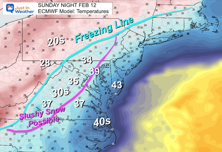
Temperatures
This is KEY! Most of us remain ABOVE FREEZING. So why is this such a big deal, especially after a few warm days and warm ground?
Well, the timing at night will help any snow stickage. Also, an event like this can produce heavy snow bursts that can overtake the warmer ground briefly.
Snow can accumulate albeit slushy, then melt when it stops.
*Remember: I just want you to keep an open mind.*
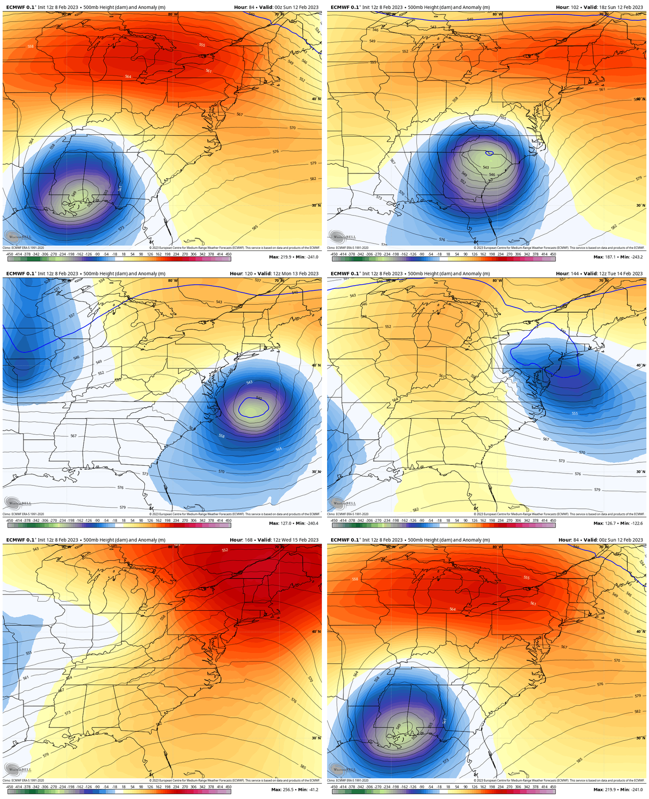
Jet Stream Into Next Week
The ECMWF Model plotted Saturday night to next Wednesday afternoon.
WE can see this Sunday blip of cold air, and perhaps another weak short wave on Valentine’s Day, then another dramatic warm up.
Yes, we are in a warm pattern overall through the end of next week.
Final Thoughts
I do believe there is still a bias in the modeling suppressing this system too far south.
We are already seeing the adjustment, and I think there will be more shifting in the next few runs.
Since we are on the edge of this potential event, just keep it in your peripheral vision for plans Sunday.
Personally I have family plans that include a bit of driving through the storm impact zone Sunday. I am monitoring this for my family and you as well.
Faith in the Flakes
Restating the records:
Latest Measurable Snow In Baltimore
- This Year Is 3rd Latest
- Feb 21 in 1973 (50 years ago)
- Feb 6 in 1914 (109 years ago)
- FEB 1 in 2023
- Jan 25 in 1992 ( 31 years ago)
- Jan 25 in 1901 ( 122 years ago)
The 2nd place year was 1914 (109 years ago). To give you some hope, or Faith in the Flakes, I would like to expand on that winter.
Mid Winter Record Warmth
72ºF on January 30, 1914 – Record High
Imagine that those people thought that winter?
Well, they broke their snow drought on February 6th, 1914, then made up for lost time!
11.4” Snow fell in February
11.6” Snow fell in March.
That season ended with 23 inches, which was above an average winter.
Subscribe for eMail Alerts
Weather posts straight to your inbox
Sign up and be the first to know!
Also See:
Winter History: Low Snow And Late Starts
See my research based on Baltimore data since 1883.
STEM Assemblies/In School Fields Trips Are Back
Click to see more and ‘Book’ a visit to your school
My Winter Outlook: Not A Typical La Niña!
I see many factors to support colder influence with multiple systems. Early and later in winter. Check it out.
Also See The Winter Outlook Series:
Winter Weather Folklore Top 20 And More Outlook Signals From Nature For Cold And Snow
Farmer’s Almanac Comparison
September Starts Meteorological Autumn: Weather Climate Stats For Maryland at Baltimore
Triple Dip La Niña Winter
https://justinweather.com/2022/09/09/winter-outlook-2023-la-nina-triple-dip-expectations/
CONNECTION TO WINTER?
If you want a snowy winter, this is what you might want to look for in the rest of the tropical season.
Rainbow Ice Cave In Mt. Rainier A Very Rare Find: Photos And Video
Wooly Bear Caterpillars
https://justinweather.com/2022/10/25/winter-weather-outlook-from-the-wooly-bear-caterpillar/
Persimmon Seeds
Click to see Top 20 and MORE
Winter Weather Folklore Top 20 And More Outlook Signals From Nature For Cold And Snow
Normals And Records: Maryland and Baltimore Climate History
Please share your thoughts, best weather pics/videos, or just keep in touch via social media
-
-
Facebook: Justin Berk, Meteorologist
-
Twitter: @JustinWeather
-
Instagram: justinweather
-


