If Models Are Wrong Again Then There Is Still A Chance For Weekend Snow
February 7, 2023
Tuesday Evening Update
Keep an open mind. That is what I have said for a couple of days, and also what I asked you to try to do last week. All winter, and for months prior, I have shown the poor performance of our mid range computer model guidance. Yes, I have shown many phantom storms one week away that never materialized for us. Or at least went from potential snow to just another rain maker.
Each time I made sure to emphasize that I expected the maps to change.
Last week I made the case for the arctic front not going as far south as projected, and the actual light snow would break the Baltimore snow drought. Well, there was a very light event with only 0.2” of snow, but it did end up snowing.
I’ve seen the model bias for years tend show a storm that ends up farther north or west.
What I want to share with you now is NOT a forecast, but does involve Super Bowl Sunday. It is my anticipation that there may be a similar model error again. I am putting my theory out here for you. I am not wish casting snow because I have important family plans that it could disrupt. However, I do think we can’t rule out the impact at the weekend.
This next event is based on a closed Low in the Jet Stream. We will be in a vernal warm weather pattern, but upper level energy can generate its own cold air. That is an early spring type of situation that can produce slushy snow.
That system is now ‘lost for us’ on the primary modeling. For a few days the European ECMWF and American GFS Models were trading off with a chance for snow. Now both are too far south.
It is important to note that the core energy is not fully in the grid system yet. Once it gets there tonight or tomorrow, then the data into those computer models will be complete. That is when we may begin to see a shift of that storm plot back up to the north.
Ocean Blizzard
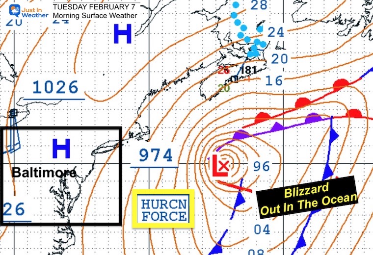
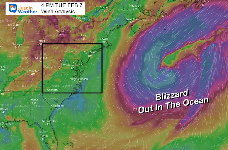
There has been a blizzard off the coast today. But this is far east off the coast and out in the Atlantic, so you would not notice. But the atmosphere remembers. I believe this will buckle the jet stream going forward.
Morning Surface Map: Winter Hurricane
The 974 mb pressure is equal to a Category 2 hurricane! This Low Pressure system has intensified much deeper than forecast, and has reached hurricane intensity!
Wind Field
There is a large circulation and the net result is pulling down colder air from the north. It will also adjust the next system upstream.
Jumping To The Weekend Storm
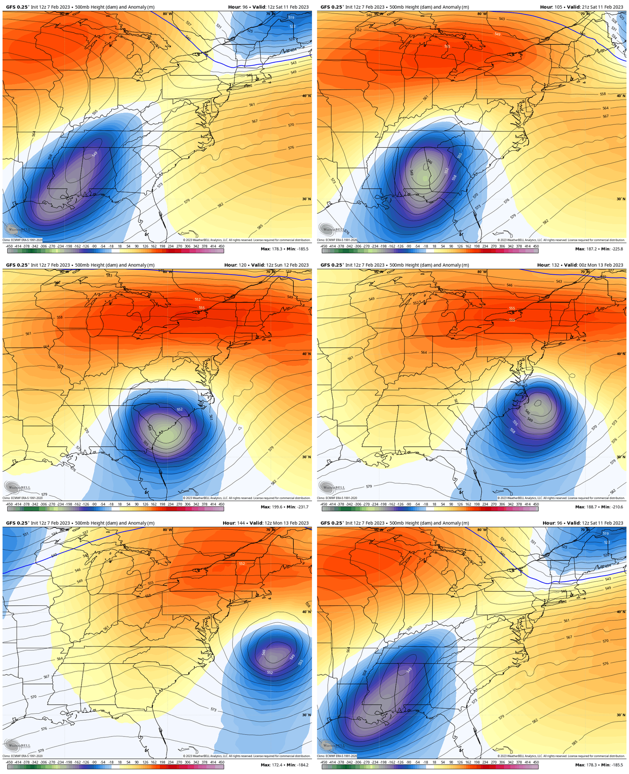
Jet Stream: The main feature is 18,000 Ft aloft.
Animation Saturday Morning to Monday Morning
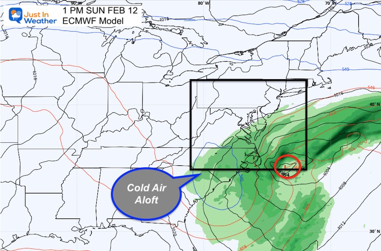
The Closed Upper Level Low pivots through to enhance the surface low. This is the source of localized cold air with the developing storm.
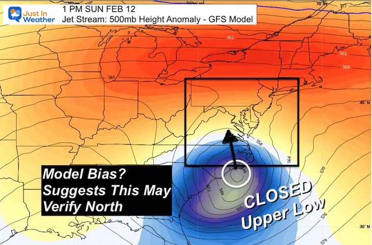
Snapshot 1 PM Sunday
I’ve annotated the Upper Level Low on the North Carolina coast.
If the model error shows up again, then we will see this feature farther north/west in the next day or two of modeling. That will shift the storm back north for the Mid Atlantic.
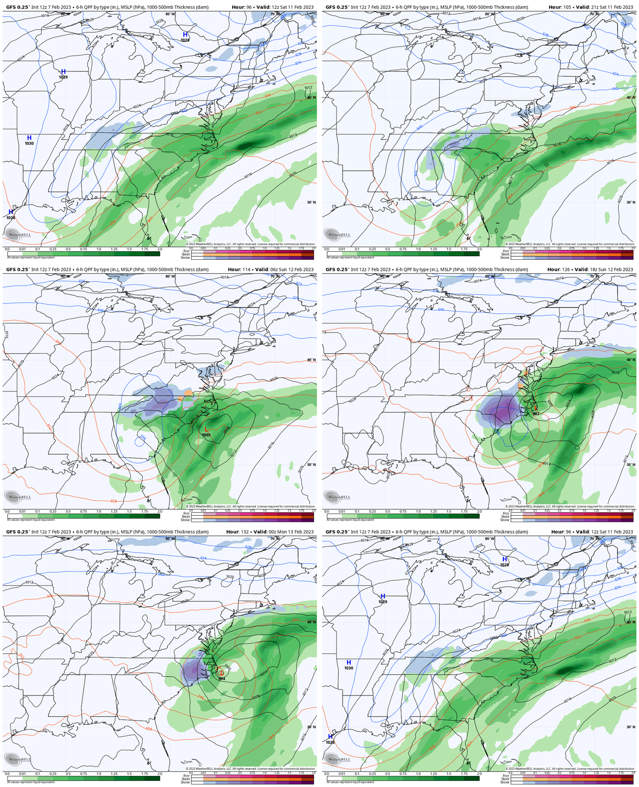
GFS Model Saturday Morning to Sunday Night
(from this morning)
This looks familiar… A cold front and band of rain too far south, is expected to be the location where the upper level energy will spin out. That’s how it looked last week. We will pick this up with the GFS Model (for starters) to show how this storm spins up….
We can see a little hint of snow on the north side into southern Maryland. But this simulation shifted the core snow southward in to eastern North Carolina. This seems a bit too far south for me.
Snapshots
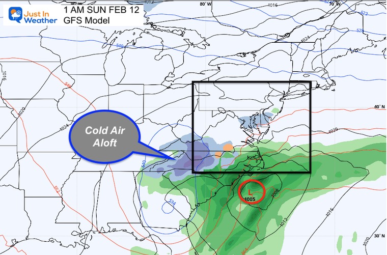
1 AM Sunday
The snow generating for inland North Carolina is based on the pocket of colder air aloft.
1 PM Sunday
This simulation shows a snowy Super Bowl Sunday for the Carolinas.

AFTERNOON UPDATE
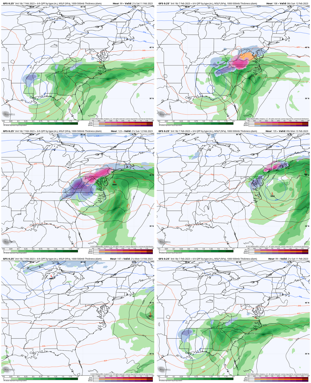
After writing this initial post, the GFS Model (18Z) afternoon run came through. This is the new storm animation. I do not like looking at these off hour plots, but it is a significant adjustment.
This has support in the ensembles members within the GFS and European.
Animation Saturday Afternoon To Monday Afternoon
This shifts the Low north and later to Super Bowl Sunday. This is worth paying attention to!
Snapshots
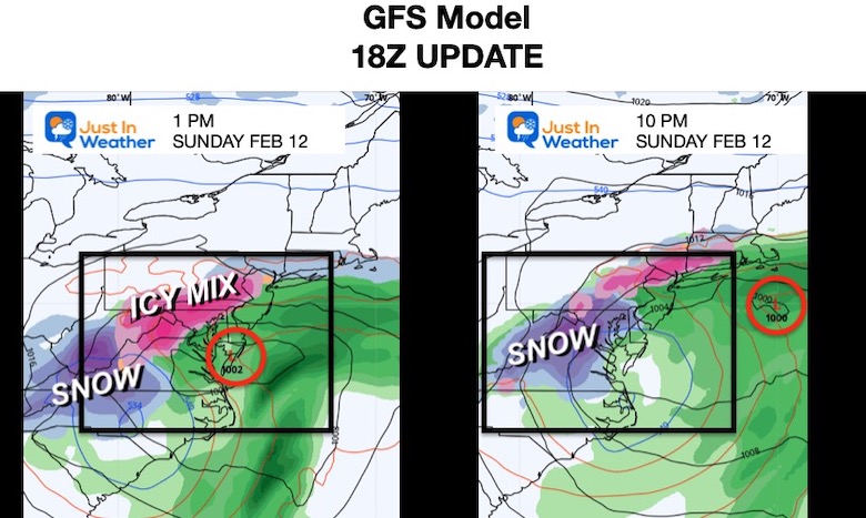
New Plots for Sunday Afternoon and Sunday Night
The suggestion here is back to the north. The timing is now focused on Super Bowl Sunday afternoon with an icy mix turning to slushy snow at night.
I still would not solidify this, but it does support my suggestion about the model error and a shift back north.
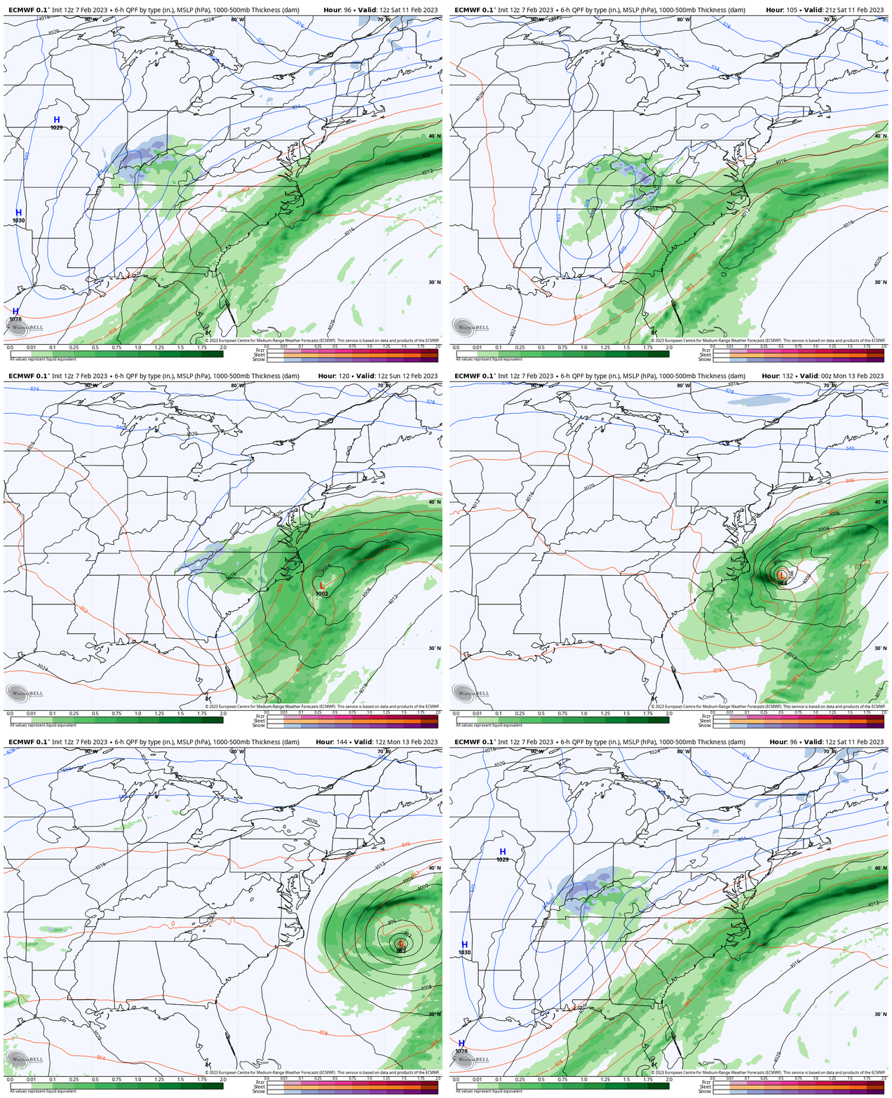
ECMWF Model
This plots the upper Low a little farther south.
Recall that last week, this model was the farthest south and showed the largest error for what actually verified.
Surface Low (forecast)
This model had the snow in the Mid Atlantic region yesterday, but now it pushed farther south and lost the snow component. I can’t buy this as the final solution.
Final Thoughts
I am not promising that we will all get snow. However, I do believe there is still a bias in the modeling suppressing this system too far south.
If that is the case, we should see a shift back north by tomorrow, then refining within 60 to 72 hours. Simply wait for more consistency in the Mid Atlantic solutions to hold from two model runs and we can take this seriously. For now it’s just a watch and waiting game. But at least you know what I am leaning towards.
Restating the records:
Latest Measurable Snow In Baltimore
- This Year Is 3rd Latest
- Feb 21 in 1973 (50 years ago)
- Feb 6 in 1914 (109 years ago)
- FEB 1 in 2023
- Jan 25 in 1992 ( 31 years ago)
- Jan 25 in 1901 ( 122 years ago)
The 2nd place year was 1914 (109 years ago). To give you some hope, or Faith in the Flakes, I would like to expand on that winter.
Mid Winter Record Warmth
72ºF on January 30, 1914 – Record High
Imagine that those people thought that winter?
Well, they broke their snow drought on February 6th, 1914, then made up for lost time!
11.4” Snow fell in February
11.6” Snow fell in March.
That season ended with 23 inches, which was above an average winter.
Subscribe for eMail Alerts
Weather posts straight to your inbox
Sign up and be the first to know!
Also See:
Winter History: Low Snow And Late Starts
See my research based on Baltimore data since 1883.
STEM Assemblies/In School Fields Trips Are Back
Click to see more and ‘Book’ a visit to your school
My Winter Outlook: Not A Typical La Niña!
I see many factors to support colder influence with multiple systems. Early and later in winter. Check it out.
Also See The Winter Outlook Series:
Winter Weather Folklore Top 20 And More Outlook Signals From Nature For Cold And Snow
Farmer’s Almanac Comparison
September Starts Meteorological Autumn: Weather Climate Stats For Maryland at Baltimore
Triple Dip La Niña Winter
https://justinweather.com/2022/09/09/winter-outlook-2023-la-nina-triple-dip-expectations/
CONNECTION TO WINTER?
If you want a snowy winter, this is what you might want to look for in the rest of the tropical season.
Rainbow Ice Cave In Mt. Rainier A Very Rare Find: Photos And Video
Wooly Bear Caterpillars
https://justinweather.com/2022/10/25/winter-weather-outlook-from-the-wooly-bear-caterpillar/
Persimmon Seeds
Click to see Top 20 and MORE
Winter Weather Folklore Top 20 And More Outlook Signals From Nature For Cold And Snow
Normals And Records: Maryland and Baltimore Climate History
Please share your thoughts, best weather pics/videos, or just keep in touch via social media
-
-
Facebook: Justin Berk, Meteorologist
-
Twitter: @JustinWeather
-
Instagram: justinweather
-


