January 30, 2023
Monday Night Update
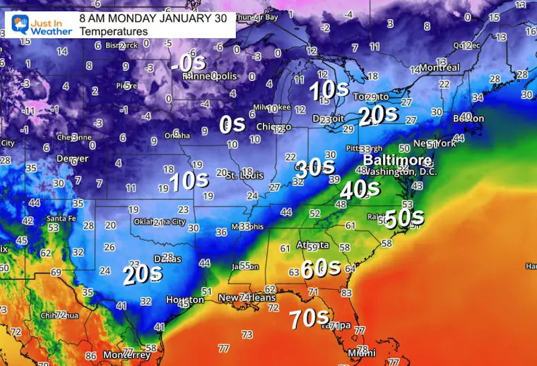
The sport of winter weather forecasting is truly underway, and the uncertainty this week is fitting for this lame winter. By lame, I am referring to a day like today when Baltimore’s BWI reached 59ºF, while other parts of Maryland and metro Washington DC reached the 60s. For context, the record high on this day was 72ºF set way back in 1914. We have had warmer days long ago. In fact that year of 1914 was followed by a February with 11.4 inches of snow, and March with 11.6 inches of snow. That was higher than the long-range average for each month. There is still plenty of winter in front of us. Keep that Faith in the Flakes.
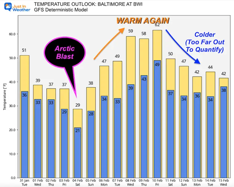
In my last few posts, I have purposely reiterated a few things. First, my high confidence in the arctic air on the way. The coldest will arrive this weekend, and after reading reports of this air mass in other parts of the country, I am buying into this trending colder.
The other thing I have mentioned a few times was asking you to keep an open mind about the snow potential. I could have easily given up when the main models lost the event, but I sensed something was wrong. I’ve seen an error like this many times and was simply anticipating that once again, it might be the case. That is why I showed models like the Canadian GEM and NAM 12 Km to contrast.
The reason I have questioned the computer model guidance is because very strong arctic boundaries that dive south into Texas tend to move slowly to the east coast. By that time they often don’t reach as far south as expected.
In this case, the closer that front remains, the better chance we have to catch one or two waves of energy that can produce snow.
The latest high-resolution modeling has shown something interesting I want to share with you. I refuse to show snow totals as we must account for the warm ground. If anything does have an impact, it would be the second impulse early Wednesday morning.
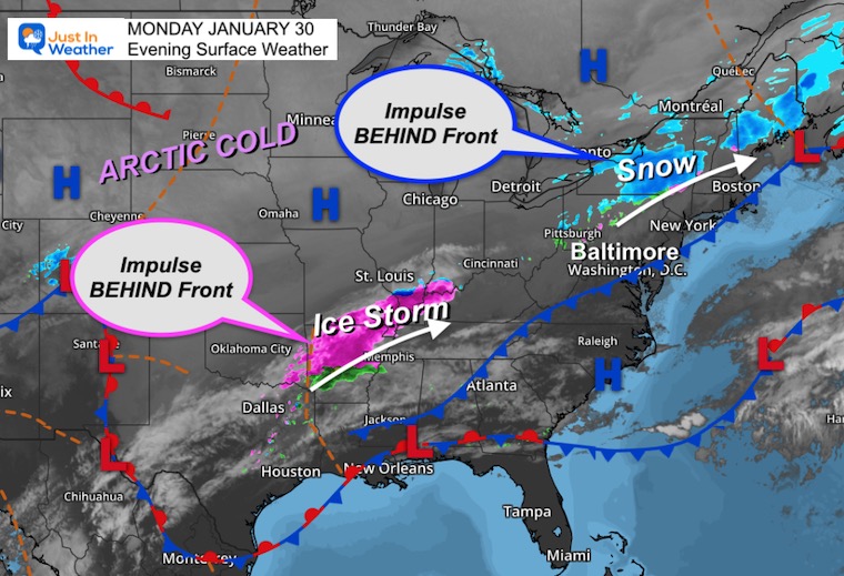
Monday Evening Set Up
Temperatures: The Arctic Air
Surface Weather
The cold front is NOT the leading edge of the arctic air or even the freezing air. That is farther back in the air mass, about 100 miles behind the front.
I do want to highlight the two current impulses ‘behind’ the front. One in central New York with snow, the other an ice storm that stretched north of Dallas to south of St Louis. It’s that setup (precipitation in the cold air behind the front) that could repeat in our region tomorrow night.
Wave 1 Tonight – Cold Front Arrives
Radar Simulation Midnight to 11 AM
The HRRR model actually has this as a minor event. The light snow or mix north maybe just rain around and south of Baltimore.
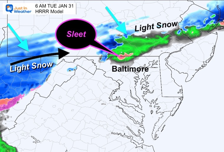
6 AM Suggestion
Light snow or sleet may fall around the Pennsylvania and Maryland border.
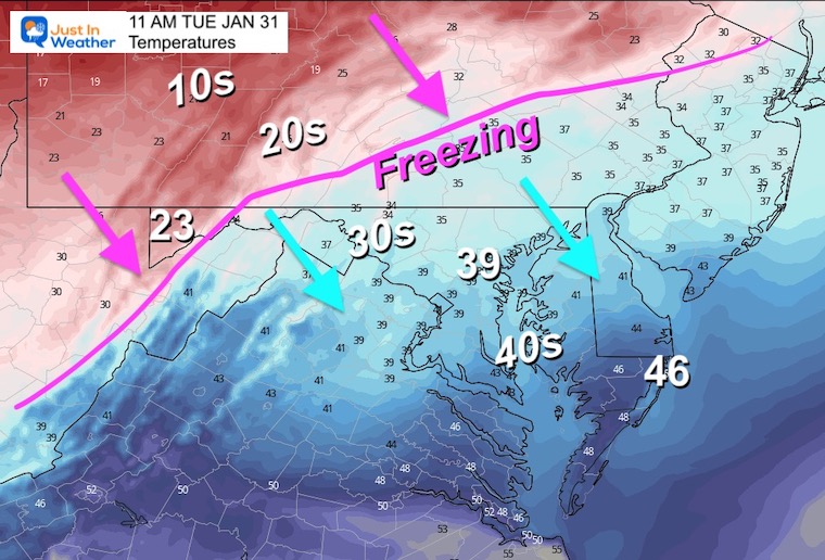
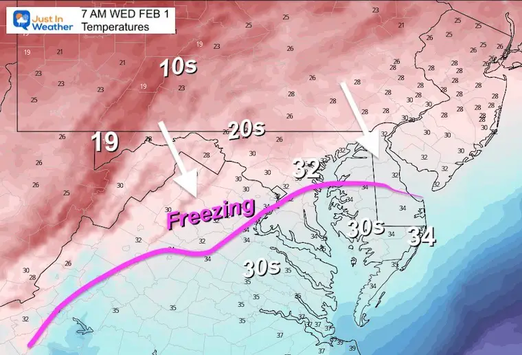
Temperatures at 11 AM
After this passes, temps will drop and hold steady. That movement of the Freezing line will appear to stall all afternoon.
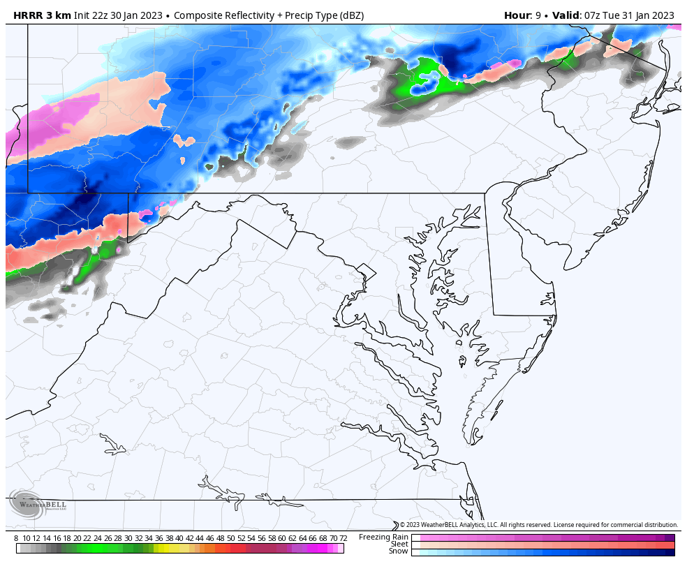
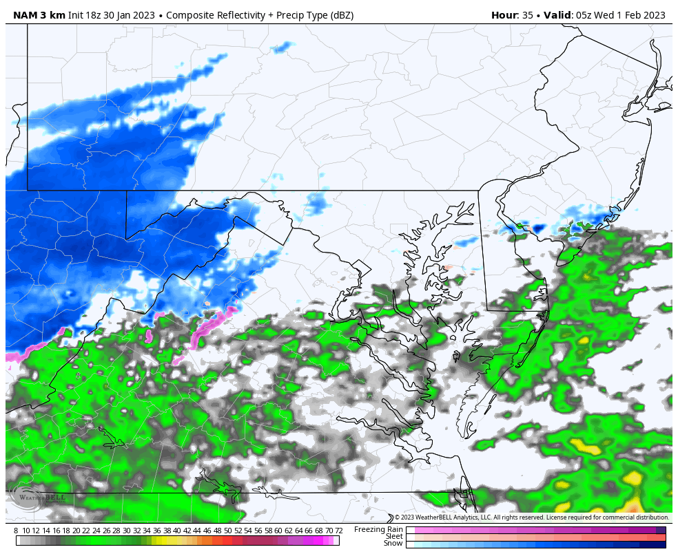
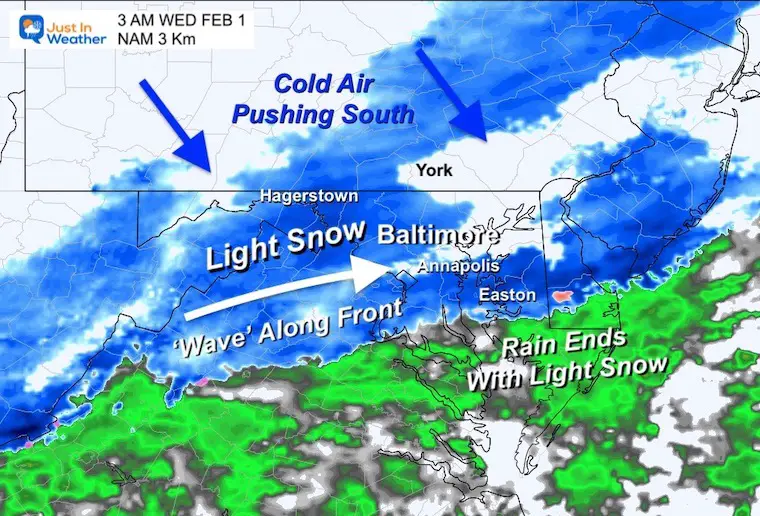
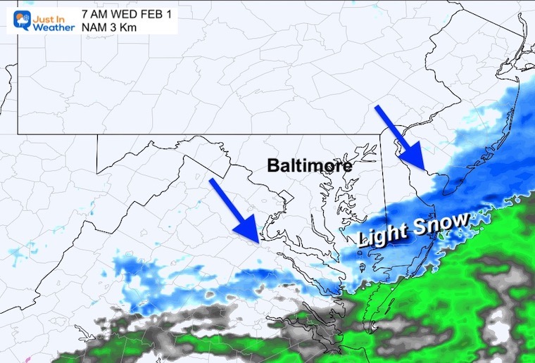
Wave 2 – Light Snow Early Wednesday Morning
Radar Simulation Midnight 12 AM WED to 7 AM
This is a stronger impulse with a little more moisture. It will be acting on colder air as well. While temps will be marginal with freezing as it falls, temps will drop behind it. If the ground is still warm to prevent stickage, there is a possibility a wet ground can ice up before sunrise.
Snapshots
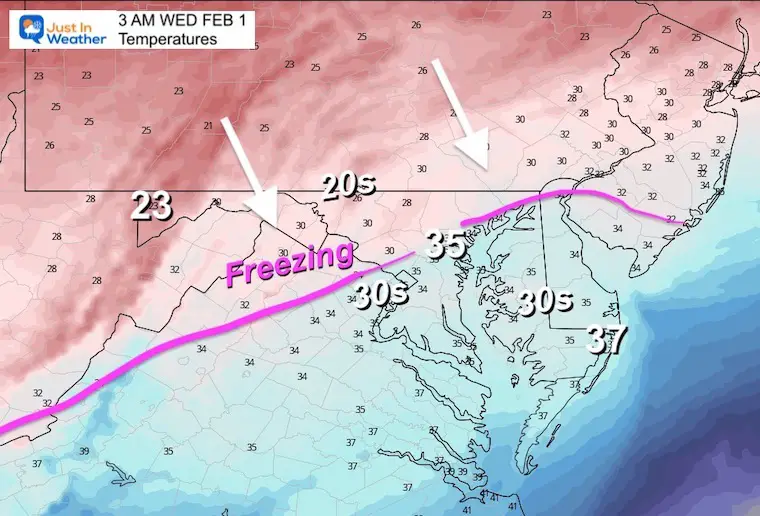
3 AM
Radar Simulation
Temperatures
7 AM
This may be moving beyond southern Maryland by sunrise.
Radar Simulation
Temperatures
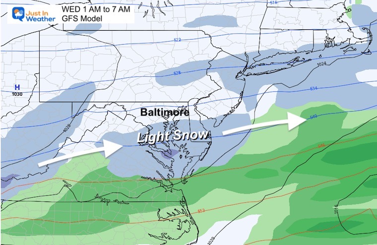
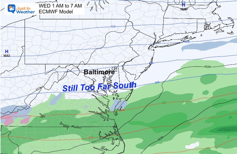
Global Models Still Not Catching On To This
GFS
This does show light snow in southern Maryland, but misses metro Baltimore
European ECMWF Model
This still keeps the frontal boundary too far south missing all of us.
Arctic Air: Brief Visit Again
This looks like Christmas weekend all over again. After the ‘stretched Polar Vortex’ influence this weekend, next week will warm up. There is going to be more cold air to follow and I would not jump on specifics about how cold (or not) it will be now. I just wanted to show you the drop and bounce over the next two weeks of forecast data.
FITF – Faith in the Flakes
Latest Measurable Snow In Baltimore
Today Is 3rd Latest
- Feb 21 in 1973 (50 years ago)
- Feb 6 in 1914 (109 years ago)
- Jan 30 in 2023 (Today)
- Jan 25 in 1992 ( 31 years ago)
- Jan 25 in 1901 ( 122 years ago)
- Jan 23 in 1966 (57 years ago)
Also See:
Winter History: Low Snow And Late Starts
See my research based on Baltimore data since 1883.

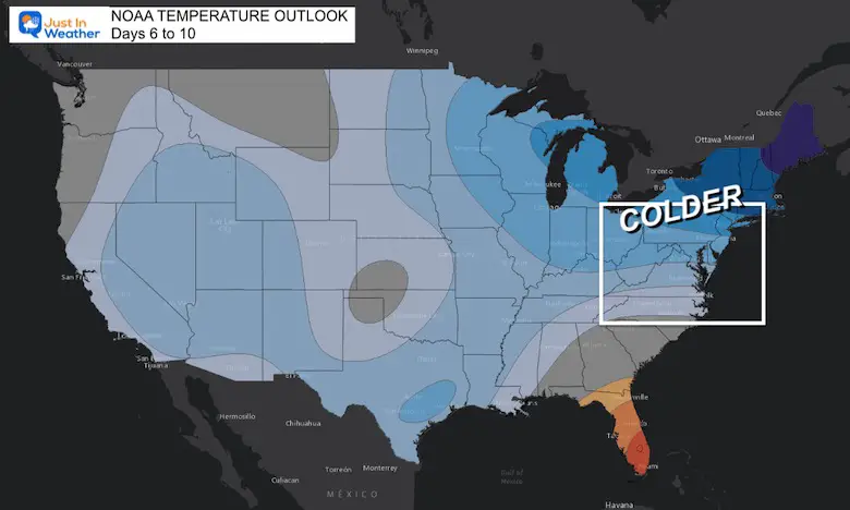
NOAA Outlook: Colder Start To February
Click here for the full report
Subscribe for eMail Alerts
STEM Assemblies/In School Fields Trips Are Back
Click to see more and ‘Book’ a visit to your school

My Winter Outlook: Not A Typical La Niña!
I see many factors to support colder influence with multiple systems. Early and later in winter. Check it out.
https://justinweather.com/2022/11/22/winter-outlook-2023-for-snow-not-typical-la-nina-plus-polar-vortex-disruption/
Also See The Winter Outlook Series:
Atmospheric Memory Suggests Active Winter Storm Pattern Outlook
Winter Outlook 2023 From NOAA Very Different Than Farmers Almanacs
Farmer’s Almanac Comparison
Winter Outlook 2023 Early Look At Snow From Two Farmers Almanacs
Triple Dip La Niña Winter
https://justinweather.com/2022/09/09/winter-outlook-2023-la-nina-triple-dip-expectations/
CONNECTION TO WINTER?
If you want a snowy winter, this is what you might want to look for in the rest of the tropical season.
Record August For No Named Tropical Storms: Closer Look At Snow Following
Wooly Bear Caterpillars
Winter Weather Outlook From The Wooly Bear Caterpillar
Persimmon Seeds
Winter Weather Outlook: Persimmon Seeds And Snow Folklore
Click to see Top 20 and MORE
Winter Weather Folklore Top 20 And More Outlook Signals From Nature For Cold And Snow
Normals And Records: Maryland and Baltimore Climate History

Please share your thoughts, best weather pics/videos, or just keep in touch via social media


