January 19 2023
Thursday Night Update
Fellow snowhounds have been bummed out by what seems to be an eternally late start to winter. We are entering the top 5 latest dates for the first snowfall, and we may stop the comparison soon. The first attempt for some snow will be Sunday, and the signal below shows it starting and ending with flakes. Then another event next Wednesday. The pattern is looking more like winter to end the month, so I can breathe easier with what I have been telling you.
I want to reinforce what I stated in my report last night: This is equivalent to early winter with warm ground and surrounding water. The atmosphere will be marginally cold, as the arctic air is not here (yet). Flakes falling do not promise stickage, and this first round or two will be more likely in the colder areas near and west or north of Baltimore.
If you see anyone post snow totals, may I make two suggestions:
- Cut the model projection in half at the least, then factor in melting.
- If a write up promotes the snow outlook, run away!
I will not trust this event in this environment until we are within a 36 to 48 hour window. So maybe Friday night, but more likely Saturday morning to get serious about what to expect. This late delay requires extra caution I pledge to exercise here with you.
Large View:
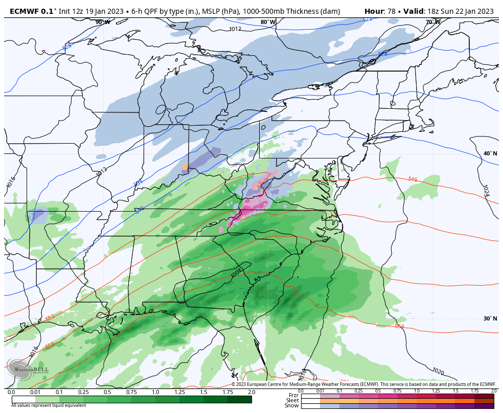
ECMWF Model 7 AM Sun Jan 22 to 7 AM Wed Jan 25
Each model update is trending colder and farther east with the first Surface Low Sunday into Monday. The second Low may track farther west.. But I do NOT trust the modeling at this time and expect further adjustments.
Closer Look: Sunday Afternoon to Monday Night
Snapshots: Suggestions
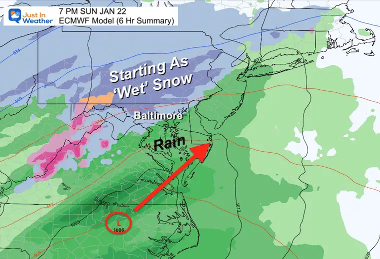
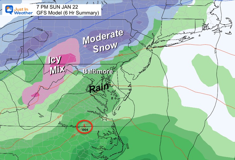
7 PM Sunday
This is a 6 hour summary of precipitation. We can expect light snow or mix north and west of the Washington and Baltimore Beltway’s after 2 PM. Snow more likely farther west, but near I-95 and by the Bay any brief initial flakes or sleet pellets would change to rain.
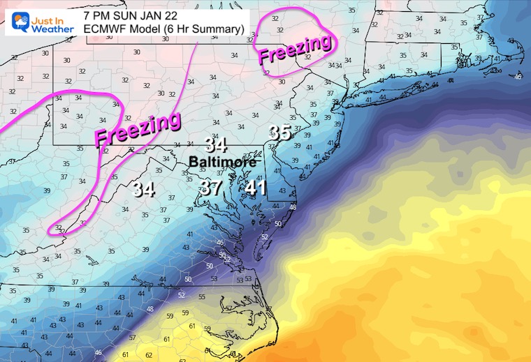
Temperatures
The Freezing Air is isolated in the higher mountains west of I-81 and in the Poconos/Catskill Mountains.
The mid 30s even in southern PA suggests snow will be slushy at best and roads will be wet. There may be some stickage, but more likely on the grass.
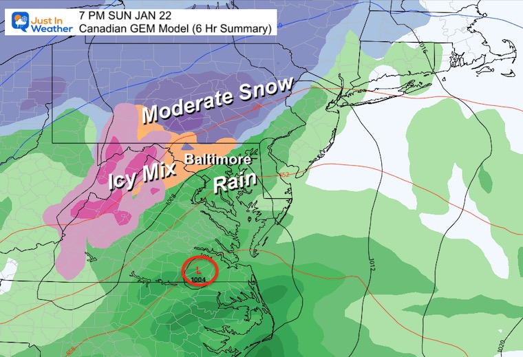
Canadian GEM Model
The orange shading for the Baltimore inland suburbs is a more practical representation of the icy/slushy mix. The snow is more likely north of the Pennsylvania line. Still of that slushy variety.
GFS Model
This plot was the warmest, and has trended colder to catch up to the others. We still have a similar set up, just additional support for snowflakes ‘falling’ inland Northwest of Baltimore.
Rain is the likely result around metro and Bay areas.
Back to the ECMWF Model….
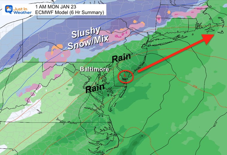
1 AM Monday
We see the rain pushing up to Harrisburg in PA. Still a slushy wet snow in central PA and north.
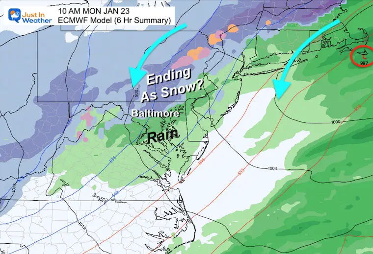
10 AM Monday
The newer development here is the wrap around snow, under the influence of the colder air aloft. This is interesting with moderate snow dropping back down into Maryland.
I need to point out that the cold air is still missing. If there is any stickage, it would be in the higher elevations and still more likely on the grass with wet roads.
Second Event
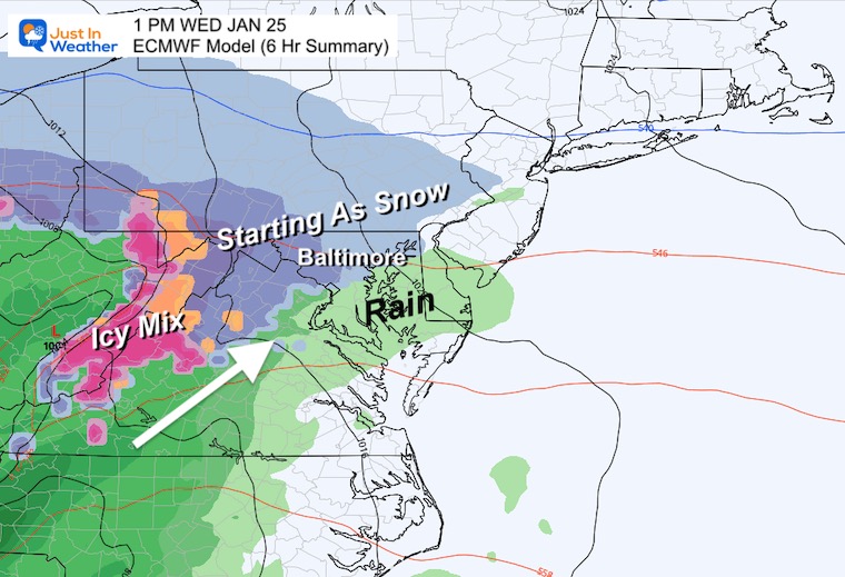
Wednesday Afternoon
The next feature that follows does show a start with snow, then transition to rain with an inland track. However, I believe the actual result of the Monday storm position could influence this one. Should that deepen and close off near Nova Scotia, it may hold our cold longer and make that mid week event more interesting with snow and ice. I am keeping an open mind on this one.
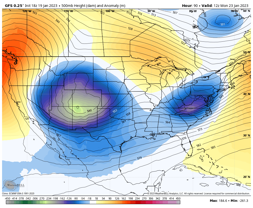
Looking Ahead: Jet Stream
Monday January 23 to Sunday January 29
The only thing I want to highlight with this loop is the pattern change. Here it is. As the trough builds mid week with the second storm, the trend to much colder air will flow end through next weekend.
There is some debate as to whether this will hold or retreat into February. I am not there yet. Given the flaws we’ve seen all winter, I am focused on short term block until we can establish some normalcy.
If you want winter, it is finally showing up. Will that produce snow? The next two weeks will tell the story. This is our window of opportunity. Faith in the Flakes.
Subscribe for eMail Alerts
SNOWSTIX – Available Now

STEM Assemblies/In School Fields Trips Are Back
Click to see more and ‘Book’ a visit to your school

My Winter Outlook: Not A Typical La Niña!
I see many factors to support colder influence with multiple systems. Early and later in winter. Check it out.
Winter Outlook 2023 For Snow Not Typical La Niña Plus Polar Vortex Disruption
Also See The Winter Outlook Series:
Atmospheric Memory Suggests Active Winter Storm Pattern Outlook
Winter Outlook 2023 From NOAA Very Different Than Farmers Almanacs
Farmer’s Almanac Comparison
Winter Outlook 2023 Early Look At Snow From Two Farmers Almanacs
Triple Dip La Niña Winter
Winter Outlook 2023 La Niña Triple Dip Expectations
CONNECTION TO WINTER?
If you want a snowy winter, this is what you might want to look for in the rest of the tropical season. (You might be seeing a lot of commercial snow removal people out this Winter).
Record August For No Named Tropical Storms: Closer Look At Snow Following
Wooly Bear Caterpillars
Winter Weather Outlook From The Wooly Bear Caterpillar
Persimmon Seeds
Winter Weather Outlook: Persimmon Seeds And Snow Folklore
Click to see Top 20 and MORE
Winter Weather Folklore Top 20 And More Outlook Signals From Nature For Cold And Snow
Normals And Records: Maryland and Baltimore Climate History

Please share your thoughts, best weather pics/videos, or just keep in touch via social media


