Sunday Night Update And Weekly Recap Of This Snow Rain Mix Thing
January 8 2023
If snow falls at night, you sleep through it, and it melts, did it really happen? I had to ask myself this question when looking at what has been discussed all week leading up to this weather system. At first glance, there were two chances, then one with a moving target of dates. It changed from Friday to Saturday, then Sunday afternoon. Now we are almost squinting to see an overnight ‘fall’ of flakes.
I understand the frustration of winter lovers. I am with you. But I need to remind all of us that about 80% of our typical snow accumulation is after mid January. In fact, 8 of the top 10 snowstorms for Baltimore fell between January 15 and February 28.
Tracking the weather for this evening over the past week was a trust building exercise in what guidance to trust going forward (it’s not the GFS). I believe I have been clear in my messaging that I did NOT expect it to amount to much, but you get so much information thrown at you from so many directions I can understand not remembering it all. I intend to do my own accountability here. I will do that below the latest forecast. So I hope you keep scrolling to see:
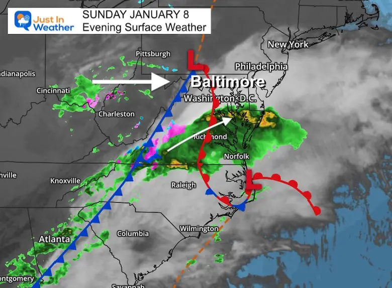
Sunday Evening Set Up
The bulk of this system is passing to our south. It has actually produced moderate to heavy rain across Virginia and into southern Maryland. The upper level energy from the mountains is the missing piece that will swing through overnight to try to do this snow thing we’ve talked about.
The system track and timing is more in line with what the European ECMWF Model has been showing. The GFS model was earlier, farther north, and the one that showed more snow. We can see now that it was wrong.
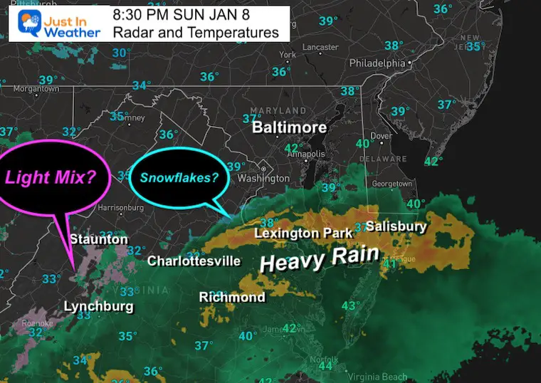
Doppler Radar at 8 AM (from the Wakefield VA radar)
This is in winter mode and on the northern fringe I had been seeing hints of flakes near Waldorf (but have not heard to confirm on the ground). It is above freezing on the ground. This is moderate to heavy rain moving through southern Maryland from Lexington Park to Salisbury.
Also a wintry mix southwest of Charlottesville.
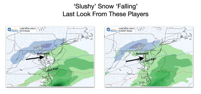
Two Main Models Still Showing Snow
Comparing the GFS and European Models now looking nearly identical for the ‘wee hours’ of Monday morning. Finally coming into agreement as we are almost there. Gee, thanks!
Short Range Models
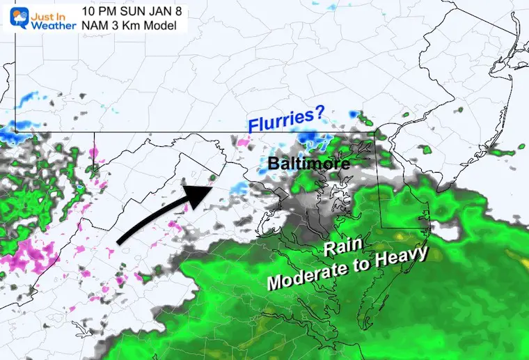
NAM 3 Km 10 PM SUN to 7 AM MON
This is the high resolution that did NOT show snow for the pre-Christmas Flash Freeze. So it can been seen as not falling into the ditch of freezing expectations.
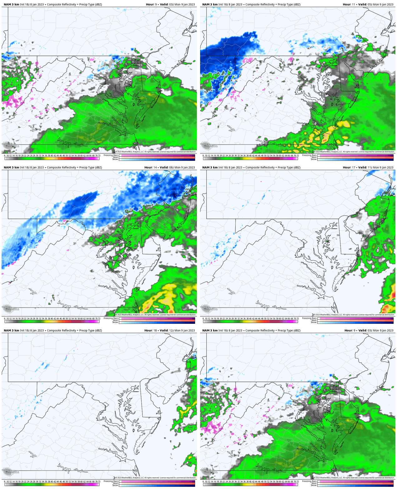
Snaphots
10 PM
The moisture over metro Baltimore looks like it might be a miss.
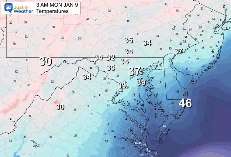
3 AM Temperatures
As advertised all week, the freezing air is really hard to come by. Add in the warmth retained on the ground, anything that may fall, it is not likely to stick. If this was a daytime event, that would have justified some of the excitement.
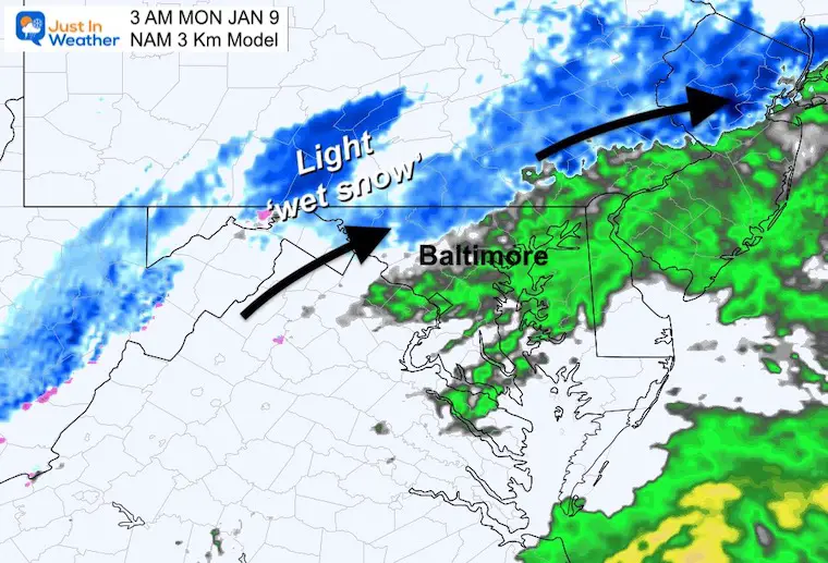
If we get a burst of snow, it looks like a window between 1 AM and 5 AM is the best chance.
3 AM Monday
If we do get light snow, this is the time window it may ‘fall’ west and north of Baltimore. This is NOT likely in metro or southern areas.
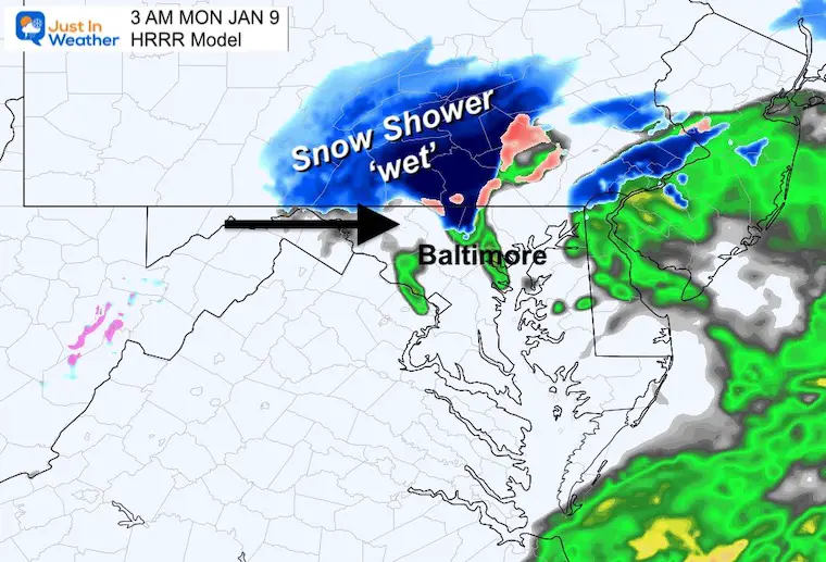
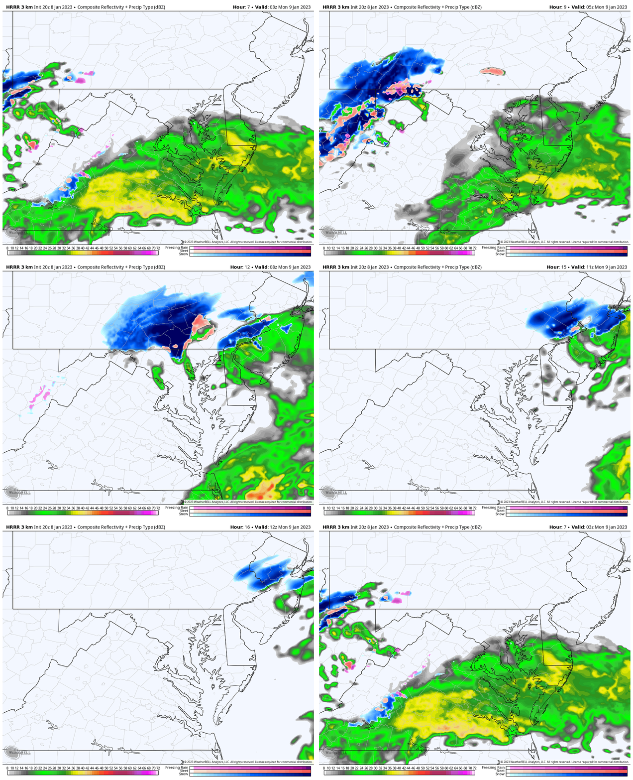
3 AM Monday – HRRR Model
This is another high resolution short range model that pushed the brief burst of snow near and north of the Pennsylvania line.
4 AM Monday – HRRR Model
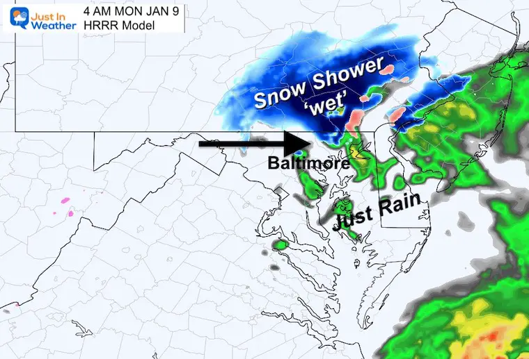
HRRR Model Animation
NAM 3 Km 10 PM SUN to 7 AM MON
I looked back at all of my reports this week to make sure my messaging was on point with what I wanted to convey and not be misleading. I do hope that landed with most, who read beyond the pictures.
Accountability :
Things I have written in reports this past week.
A link to the relative article is attached in the date posted.
“It has looked like the atmosphere was going to try to produce something but the timing has been tough to pin down. I would expect this time frame to remain a moving target.” – Jan 3 Report when the GFS showed snow on Saturday night.
“I want to share this Saturday night forecast to highlight the minimal cold air. This is not to say we can’t generate colder temps, But with marginal temps following a week with many days in the 60s, I think road stickage will be hard to come by.” – Jan 3 night report, when it looked like two weather events were possible.
“The energy keeps shifting and all I can do is show you what I see. It is painfully obvious that the models are having a tough time handling the data available. That is why I have been vague on purpose by saying, “something is trying to form this weekend” – Jan 4 Morning Report
“‘Something’ is going to try.
This thing has wavered with days and intensity, and now the GFS is still overplaying and the ECMWF Model is minimizing. I do not expect much from this, and I hope I have made that clear with my recent reports. “ – Jan 4 Night Report
“It is almost comical at this point: The GFS Model is still trying to emphatically produce a snow burst, while the European ECWMF is ‘Ho-Hum’ with light mix at best. The difference in location (GFS is farther north), and timing (GFS is faster).” – Jan 6 Morning Report
“With this knowledge (warm ground and air temps), I have a hard time considering the snow forecast from these models, so I am not showing them.
Also note: The GFS was the model pushing more snow with the flash freeze before Christmas. If you don’t remember what happened, there is a reason… It was not much more than a brief burst of thunder sleet on I-95. We had some ‘stuff’ but the GFS was overdone. I am using this Sunday’s event to point out whether it continues to overplay its hand, or can finally be taken more seriously.” – Jan 6 night report
“The GFS Model has lost some edge by overplaying a few events. This included that pre-Christmas Flash Freeze front.
I think a hybrid between these solutions is best, but it is important to see which is closer because: As we look at the next potential storm, the timing, and track south or north can result in a better handle on rain or snow Friday.” Jan 7 report
This week ahead will be uneventful with seasonal temperatures. This system was the blip in the warm pattern, but NOT the pattern change. I have said that for the past 10 days. However, I still see winter fighting back even if the models don’t show much for now. I will explain in my report tomorrow night.
The typical core of our snow events is still in the next 7 weeks. Hang in there and Faith in the Flakes.
FITF
Faith in the Flakes Gear
What is Faith in the Flakes?
It began with my son in 2009
October 27 Nor’easter Recap Still Breezy Then Next Storm Friday
SNOWSTIX – Available Now
STEM Assemblies/In School Fields Trips Are Back
Click to see more and ‘Book’ a visit to your school
My Winter Outlook: Not A Typical La Niña!
I see many factors to support colder influence with multiple systems. Early and later in winter. Check it out.
October 27 Nor’easter Recap Still Breezy Then Next Storm Friday
Also See The Winter Outlook Series:
October 27 Nor’easter Recap Still Breezy Then Next Storm Friday
Farmer’s Almanac Comparison
September Starts Meteorological Autumn: Weather Climate Stats For Maryland at Baltimore
Triple Dip La Niña Winter
CONNECTION TO WINTER?
If you want a snowy winter, this is what you might want to look for in the rest of the tropical season. (You might be seeing a lot of commercial snow removal people out this Winter).
Rainbow Ice Cave In Mt. Rainier A Very Rare Find: Photos And Video
Wooly Bear Caterpillars
https://justinweather.com/2022/10/25/winter-weather-outlook-from-the-wooly-bear-caterpillar/
Persimmon Seeds
Click to see Top 20 and MORE
Winter Weather Folklore Top 20 And More Outlook Signals From Nature For Cold And Snow
Normals And Records: Maryland and Baltimore Climate History
Please share your thoughts, best weather pics/videos, or just keep in touch via social media
-
Facebook: Justin Berk, Meteorologist
-
Twitter: @JustinWeather
-
Instagram: justinweather


