


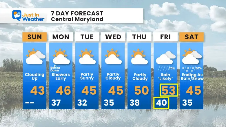
May 17 Clouding Up Ahead Of A Soggy Preakness Saturday Then We Warm Up
Friday May 17 Morning Report Today may end up mild, but it will bring an increase in clouds ahead of our next storm. If you are heading to the mountains,…
January 8 2023
Sunday Morning Report
The amount of frustration over the lack of snow is bubbling up. I feel it too, but I want to restate that this next event was never expected to be a stickage event. I made sure to show the warm temps and NOT show snow totals, in addition to stating that to my clients and in my reports. There will be some light snow mix tonight. It will be later and more likely inland.
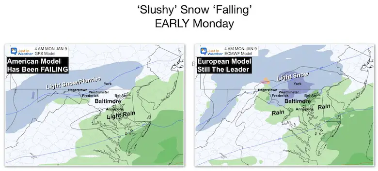
I realize some just look at the weather maps, but I write a lot of elaboration as well. I continue to work on the best messaging method. With that I have deliberately been comparing the GFS to the European Models all week. Now that this system is here, one thing has been shown again:
The GFS Model has been FAILING! This is the American model most weather apps use, but I will now put it on the back burner until it proves itself. The European Model continues to be the better guidance and I will resume relying heavily on that going forward.
That said, here are the headlines, with more details below.
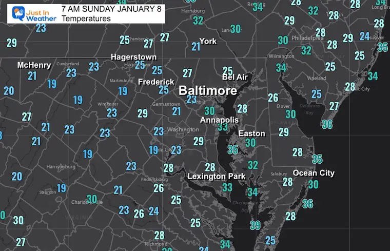
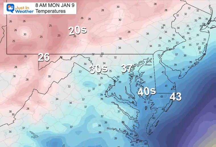
It has cleared and inland areas have dropped into the 20s.
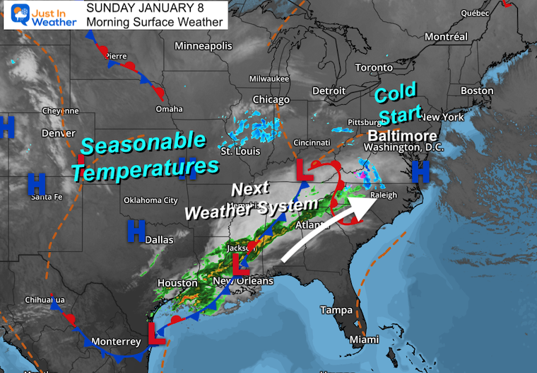
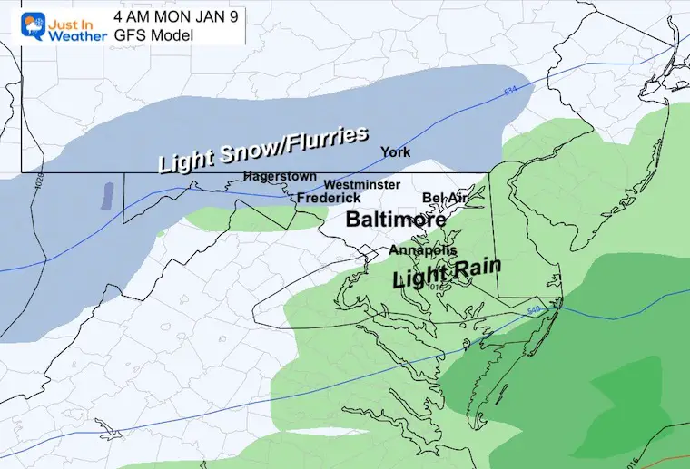
There is our weather system, which looks impressive this morning. The debate has been on the arrival time and how much energy would reach us. The American GFS Model brought it farther north with more snow/sooner. It is wrong, again!
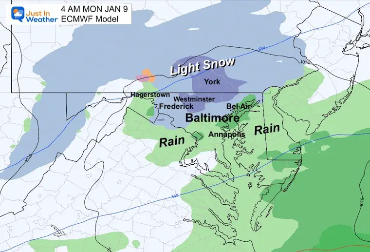
It is looking more like the European Model is slower, which is farther south. The result will be less stuff and more rain in central/urban areas.
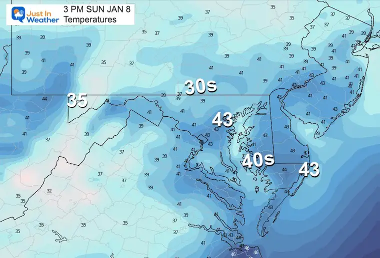
These numbers are near seasonal average highs. Clouds are expected to build in and fade the sun during the day.
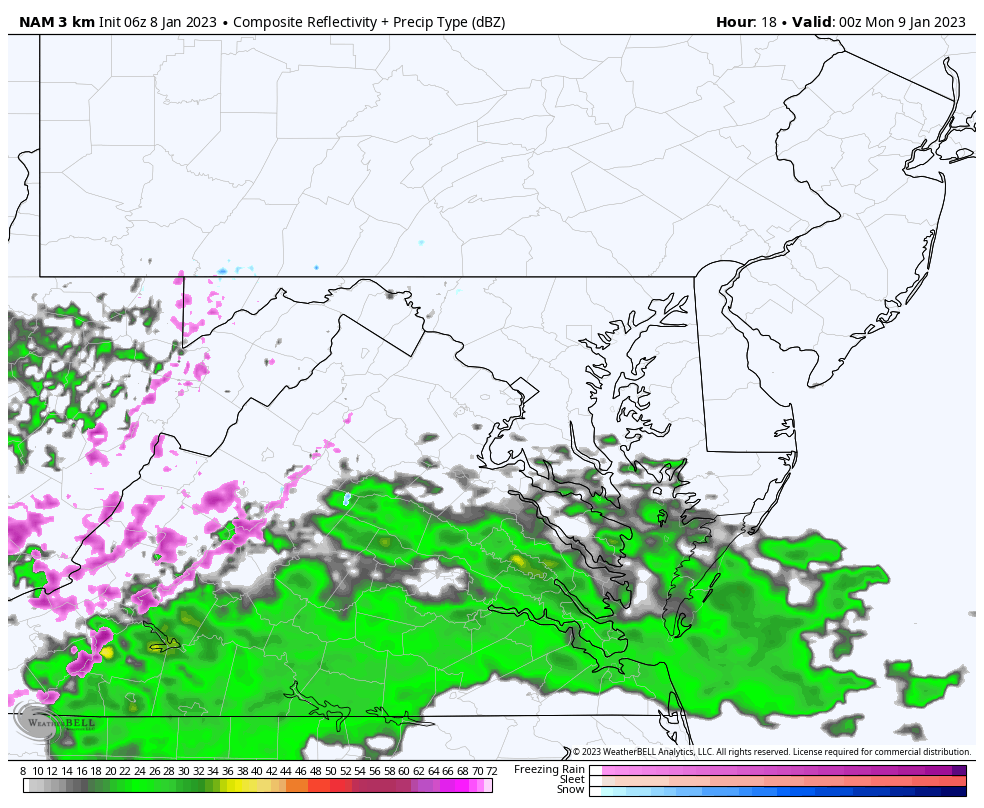
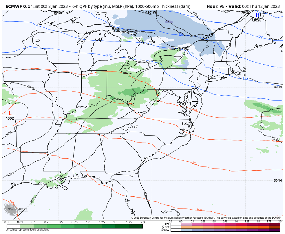
This short range high resolution model shows rain in southern Maryland this evening… and expanding north overnight.
If there is local light snow, it will be north and west of Baltimore City. Including – Hereford Zone, Carroll/Frederick Counties in Maryland, and into southern Pennsylvania. NO STICKAGE expected on roads!
All week I have showed these two side by side. The American GFS Model was most robust with snow, which it has done in prior systems… and was wrong! This is the model used for most weather apps, which is why I show it.
The European Model was consistently later and weaker… still swinging light snow north.
I will be relying more heavily on the European Model going forward!
Light evening rain will spread in from the south. The light snow part will be around and after midnight, ending by sunrise.
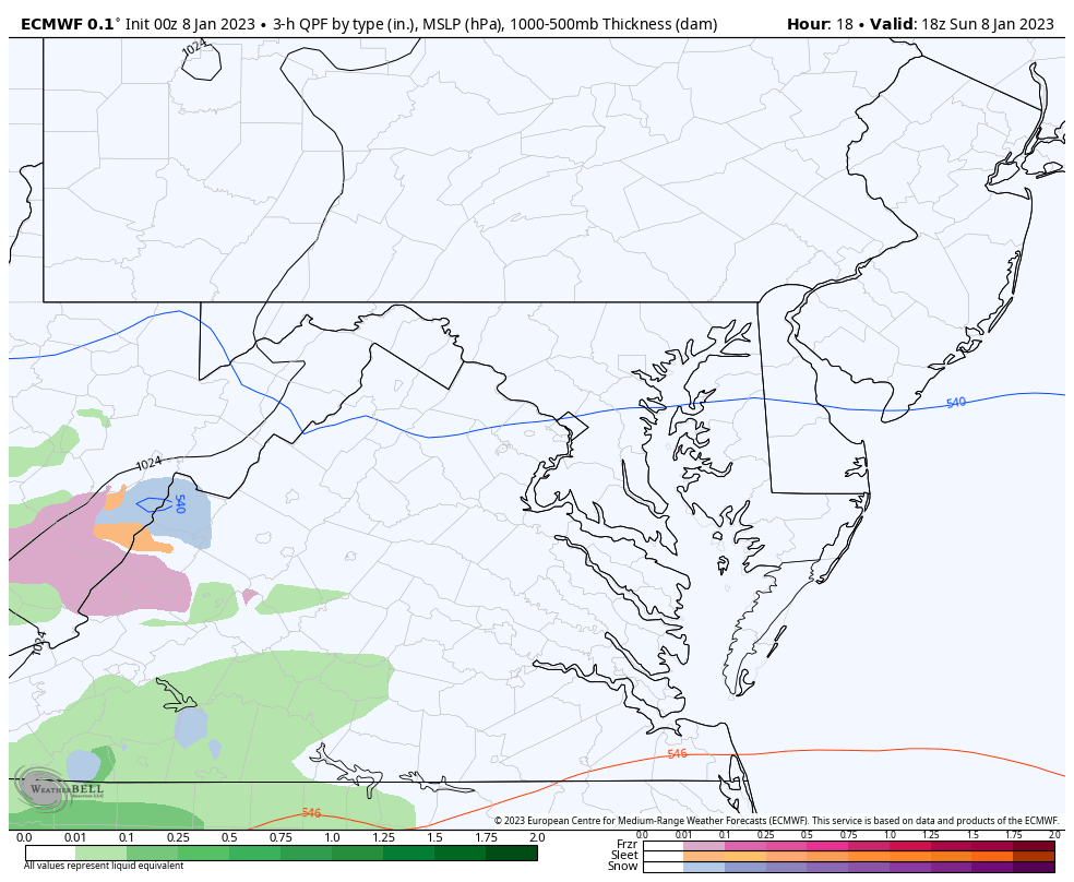
ECMWF Model shows where snow may fall… This is NOT stickage. I do hope my reports made that clear: The ground is warm AND temps are missing the freezing line.
A little later to catch up, but here we see a later and weaker event as well.
Normal Low in Baltimore: 26ºF
Record 4ºF in 1970
SNOW: 6.7” 1996
Normal High in Baltimore: 43ºF
Record 70ºF 2008
Note: The showers should be ending before sunrise, then there will be some clearing.
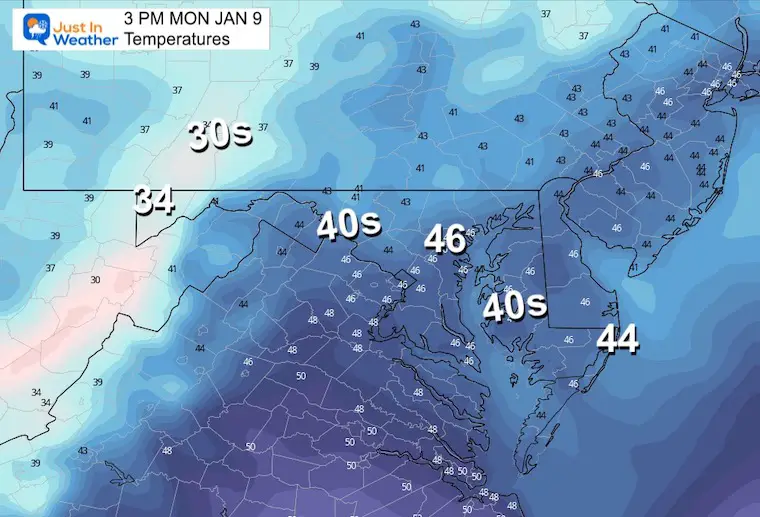
Temps back to near seasonal average highs.
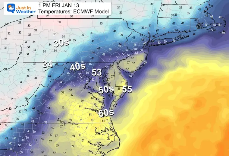
The next storm still looks like the end of the work week. It may begin as early as Thursday night, but the focus will be on Friday. Here the ECWMF Model is showing strong Low Pressure passing directly over us. The net result is a weak event, but ending with some snow or mix on Saturday.
Even with higher credibility, I expect this will change given the fact that timing multiple ingredients has been a challenge and the net result will adjust how the storm really develops.
IMPORTANT: The Track of this Low can make the difference of 10 to 20 degrees on the thermometer. This is the temperature spread Friday afternoon on the ECMWF Model. If you have questioned my 7-day forecast being colder, it was based off a mix of this model and ‘assuming’ how the model bias would shift the storm and temperature spread. I still expect there will be adjustments here, and it can go either way.
We are at the whim of model guidance and it has been poor. If you are reading to this point of my reports, you are caring about my insight, beyond just the model maps. I share my thoughts and suggestions, carefully NOT making promises.
I have LOW CONFIDENCE in model guidance, so as I continue to show them to you, I will add my suggestions for how they are trending and what I anticipate might be different with the actual event.
So with the storm next week: Just like watching snow chances, I think this rain event will look different than shown today. I am watching closely for the surrounding atmosphere that will influence it. I will share that in a follow up report.
This has NEVER been advertised to be the pattern change. It is closer to normal, but not arctic cold. I have highlighted the WARMER CHANGE I made to the temperatures on Friday based on the European Model storm track.

December 5th Snow In Baltimore And The Start Of Faith In The Flakes FITF

Click to see more and ‘Book’ a visit to your school

I see many factors to support colder influence with multiple systems. Early and later in winter. Check it out.
Winter Outlook 2023 For Snow Not Typical La Niña Plus Polar Vortex Disruption
Atmospheric Memory Suggests Active Winter Storm Pattern Outlook
Winter Outlook 2023 From NOAA Very Different Than Farmers Almanacs
Winter Outlook 2023 Early Look At Snow From Two Farmers Almanacs
If you want a snowy winter, this is what you might want to look for in the rest of the tropical season. (You might be seeing a lot of commercial snow removal people out this Winter).
Record August For No Named Tropical Storms: Closer Look At Snow Following
Winter Weather Folklore Top 20 And More Outlook Signals From Nature For Cold And Snow
