


May 19 Weather Sunday Starts Foggy The Warming With Sun And Summer Heat On The Way
Sunday May 19 Morning Report The aftermath of the rainy Saturday is plenty of leftover moisture. This has left us with a bit of humidity and areas of thick fog…
December 23 2022
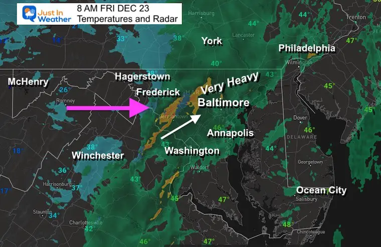
8 AM Friday Morning Update
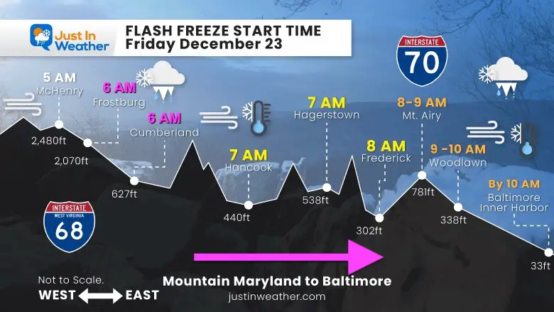
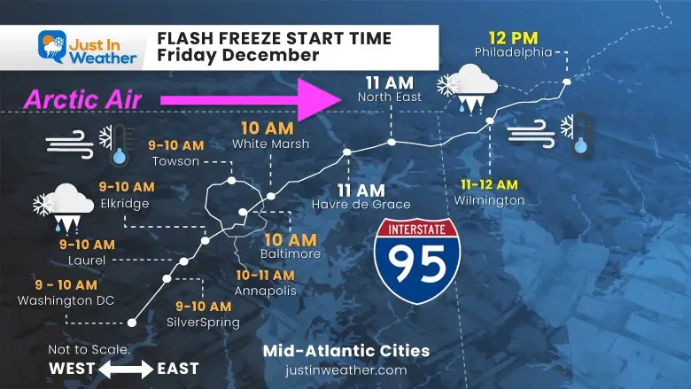
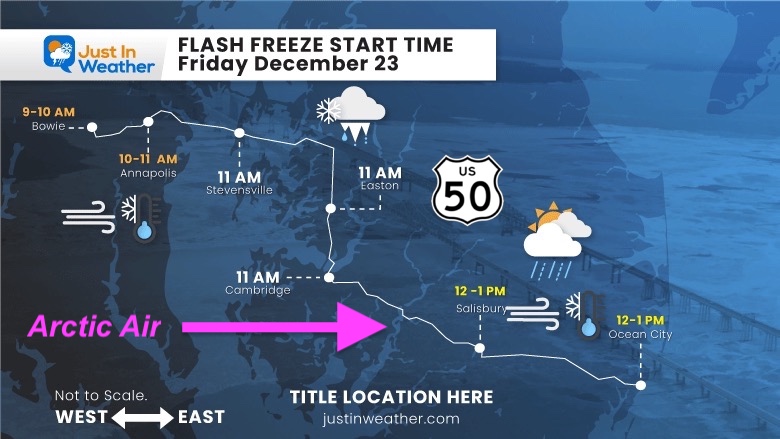
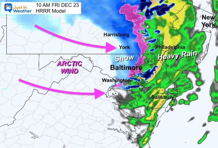
We are tracking the freezing line and transition to brief snow across the region. This is holding pretty close to the schedule, maybe just 30 to 60 minutes slower than my timeline. The rain, perhaps sleet and brief snow is intense along the front. This is NOT The Day After Tomorrow, but it might feel like it. The temperatures and wind forecast maps below tell the story of how fast and hard the temps will drop and the wind will pick up. We have had conditions like this before, but it is rare. It will hurt to be outside and I hope you avoid driving during the transition.
Rain has been falling and is still moderate to heavy in spots ahead of the front. The ground is soggy and temps will drop 20 degrees in a matter of 1 to 2 hours. Add in some snow, even if minimal, and that is the concern to allow moisture around to freeze “in a flash”. I truly advise not being on the roads when this transition happens. My new Profile Timeline maps for areas highways are below to assist.
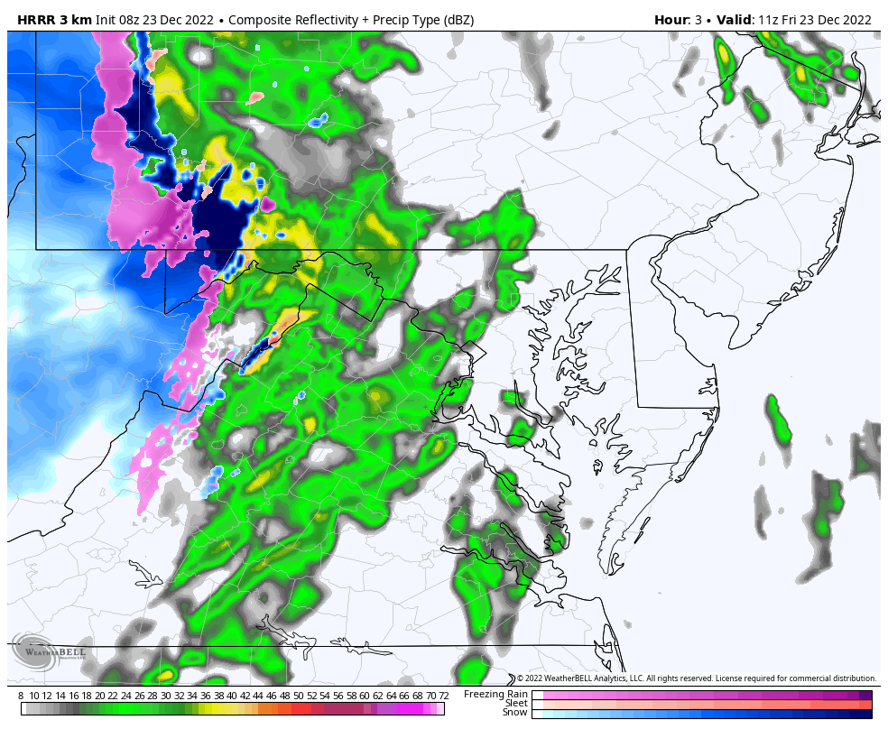
Low resolution look at the radar and approaching freezing line.
I was given the quote, “It’s Crazy Here”! – From Eldersburg. This is an intense squall line, and justifies school closings, regardless of the freeze.
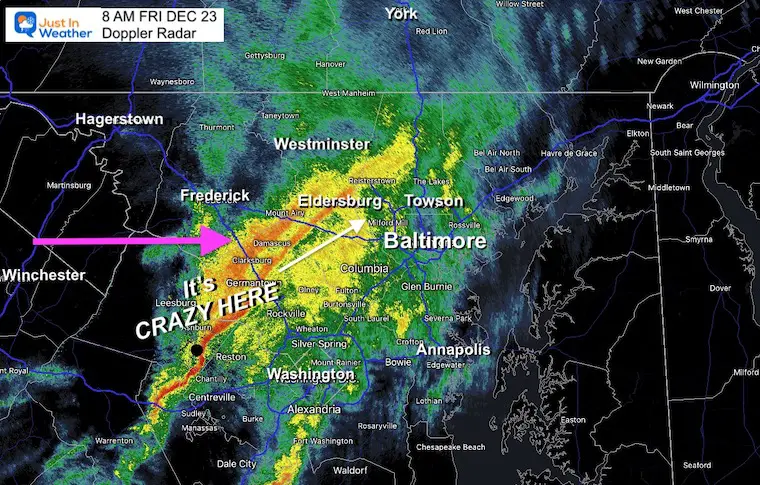
I want to highlight that the snow part will be minimal, but could impact just enough. New Advisories have been issued in Pennsylvania where snow squalls are possible and will accumulate a little more, adding to the road issues.
Caution: I would just avoid travel this morning, so you don’t risk getting stuck in traffic. It will be painfully cold this afternoon, but roads will be passable.
If you are traveling for the holiday, take a cold kit in your car (blanket, extra clothing, food, and water), just in case you get in long traffic lines while in the deep freeze.
This is close, but might be within an hour slower/later than shown.
There will likely be WIND RESTRICTIONS On The Bay Bridge
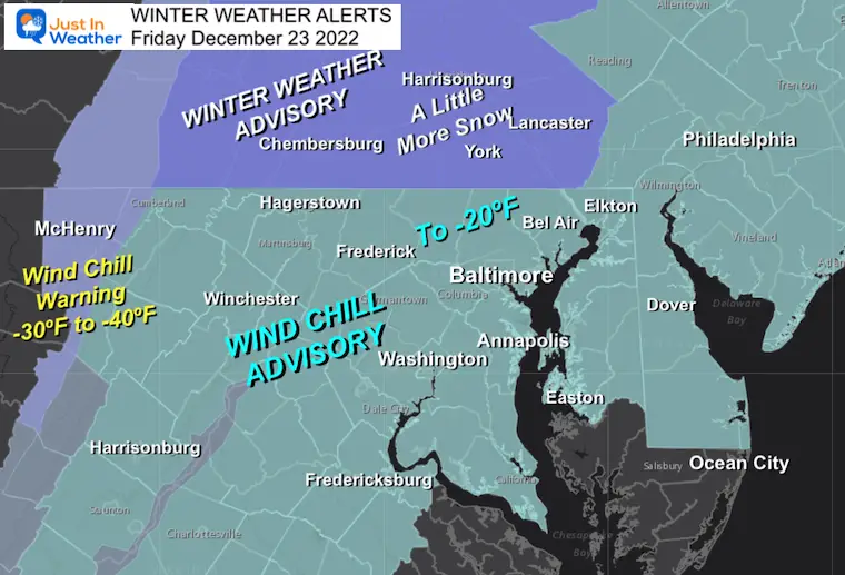
Winter Weather Advisory – Southern Pennsylvania: Snow Squalls may accumulate 1 to 3 inches and add to road issues.
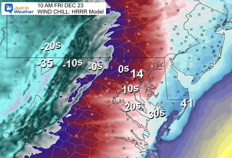
Wind Chill Advisory: Dropping to -20ºF this afternoon into Saturday morning.
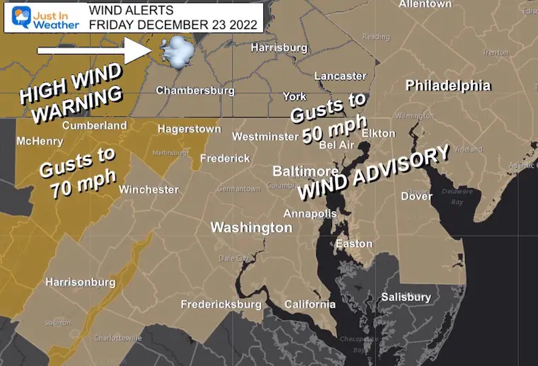
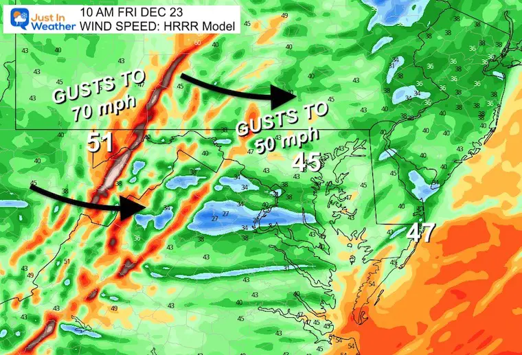
Most of the region will experience wind gusts between 40 and 50 mph, while up to 70 mph in the mountains.
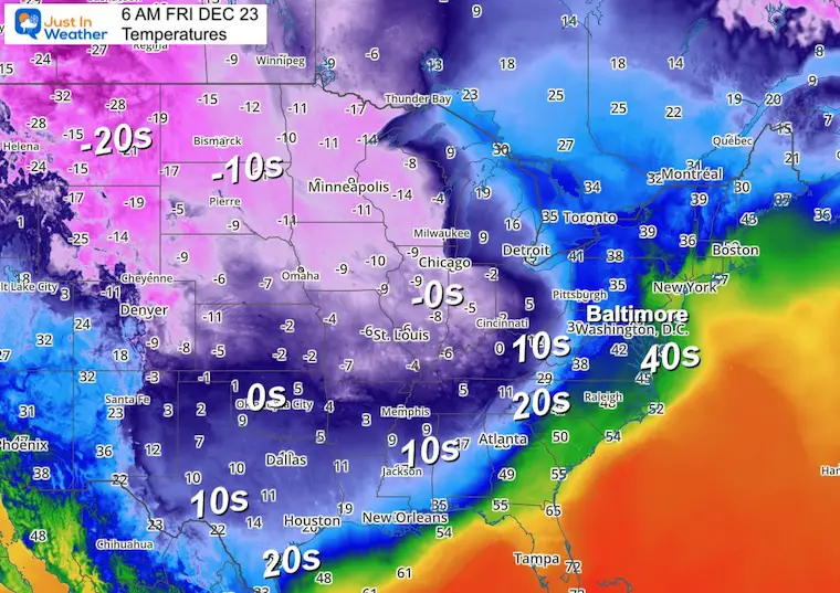
This has extended to 20s to Houston, TX and Atlanta, GA. Single digits in Memphis!
Below Zero from Chicago and westward! This is all racing our way to the East!
Tracking the Cold Front… This is rapidly changing and I intend to have an update on this map.
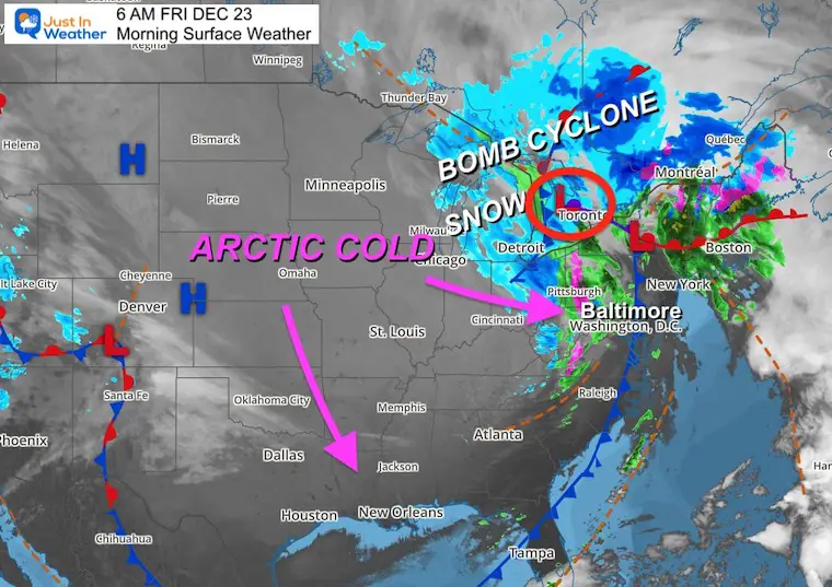
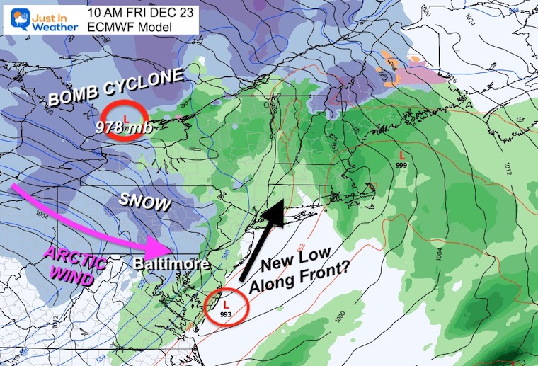
The Bomb Cyclone will have rapidly dropping pressure. That is the wind machine that will be responsible for this mess.
New Low Pressure is expected to form along the arctic front. That is the element that will make or break how much snow will fall. If it forms, we get more snow. If it is slower to spin up, then less snow for us.
HRRR Model: 6 AM to 1 PM
This is a quick hit! Reminder: The amount of snow will depend on Low Pressure forming along the front.
Most likely a dusting to 1 inch in central Maryland, a little more in southern PA.
Radar Simulation
It should reach Baltimore by this time.
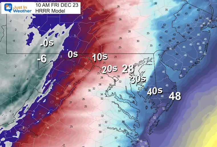
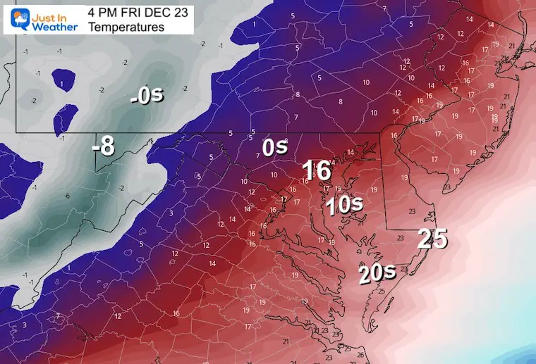
These are the expected thermometer readings.
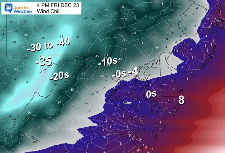
These are the wind chills. What it should feel like!
Top Wind Speed
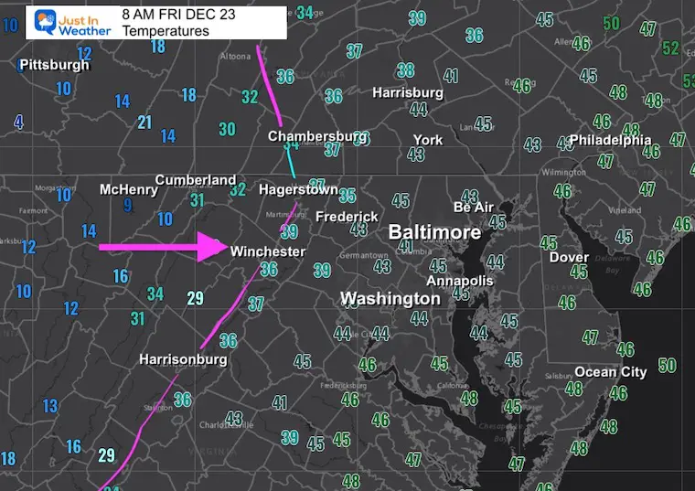
Temperatures
Yes, Teens in Baltimore and mid 20s for Ocean City!
This is going to be painful!
-30ºF to -40ºF in the mountains, BELOW ZERO for Baltimore, and Single Digits to the beaches.
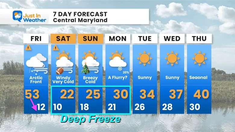
TODAY December 23
Normal Low in Baltimore: 28ºF
Record 0ºF in 1960
SNOW: 8.0” 1963
Normal High in Baltimore: 46ºF
Record 69ºF 1990
The coldest air will settle in through the weekend, then slowly modify next week, back close to seasonal.

December 5th Snow In Baltimore And The Start Of Faith In The Flakes FITF

Click to see more and ‘Book’ a visit to your school

I see many factors to support colder influence with multiple systems. Early and later in winter. Check it out.
Winter Outlook 2023 For Snow Not Typical La Niña Plus Polar Vortex Disruption
Atmospheric Memory Suggests Active Winter Storm Pattern Outlook
Winter Outlook 2023 From NOAA Very Different Than Farmers Almanacs
Winter Outlook 2023 Early Look At Snow From Two Farmers Almanacs
If you want a snowy winter, this is what you might want to look for in the rest of the tropical season. (You might be seeing a lot of commercial snow removal people out this Winter).
Record August For No Named Tropical Storms: Closer Look At Snow Following
Winter Weather Folklore Top 20 And More Outlook Signals From Nature For Cold And Snow
