


May 7 Warming Up With Only Isolated Showers And Thunderstorms
Tuesday, May 7 Morning Report We are entering a period of warming with less rain for a few days. We will still see some isolated showers and thunderstorms pop up…
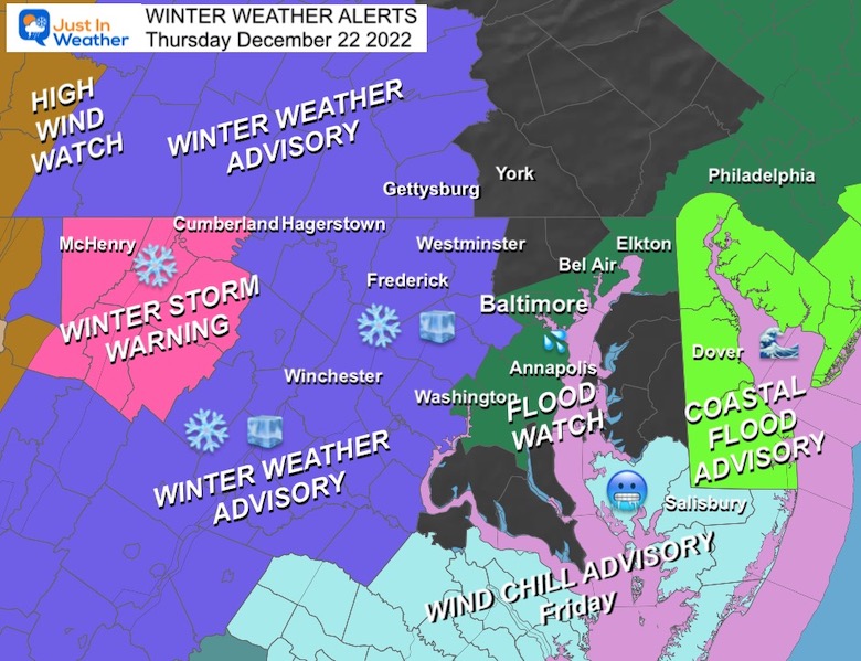
December 22 2022
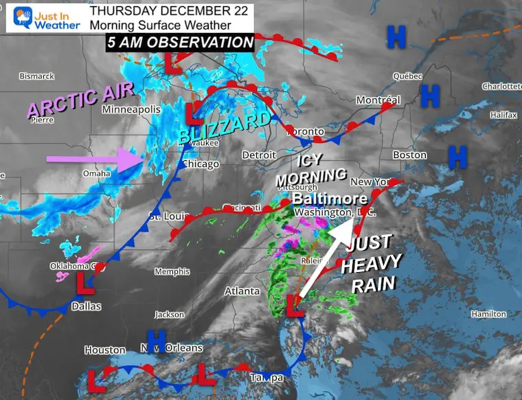
Early Morning Thursday Update
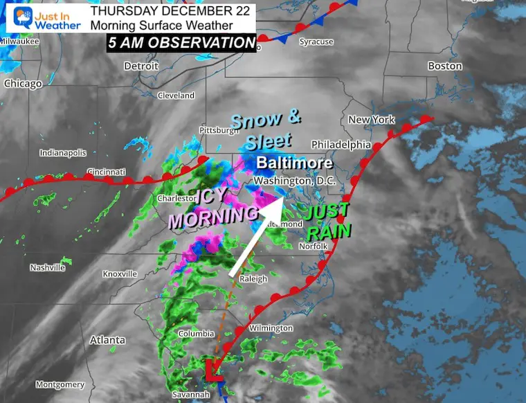
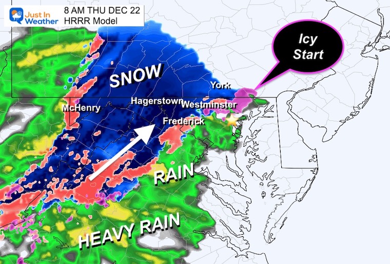
The focus on this report is for this morning as the faster timing I have been mentioning has been getting even faster. The next result for this Part 1 of the storm has already brought in bands of flurries and sleet to central Maryland and Southern Pennsylvania.
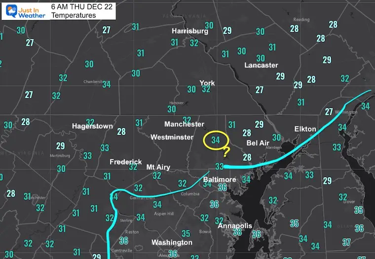
It is important to note that ground temperatures are much colder that last week, so where air temps are at freezing, anything falling may very well stick on the ground. This is developing this morning and will be expanding through the commute and bus routes, and my concern is that the later half could get troublesome INLAND! City and Bay areas will be just rain.
School Delays: In Maryland – Carroll and Frederick Counties are on a 2-Hour delay. I expect there will be more issues expanding east before 8 AM. Please be careful into western Howard, Northern Baltimore and Harford counties as well.
In Maryland Howard , Carroll County, and Montgomery Counties were added. It is possible not all of the counties get slick, but parts of them will!
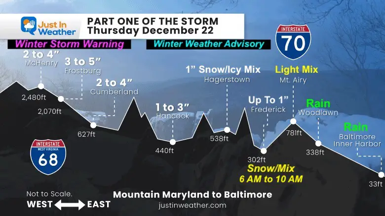
Winter Storm Warning where the mountains may see over 3 inches of snow.
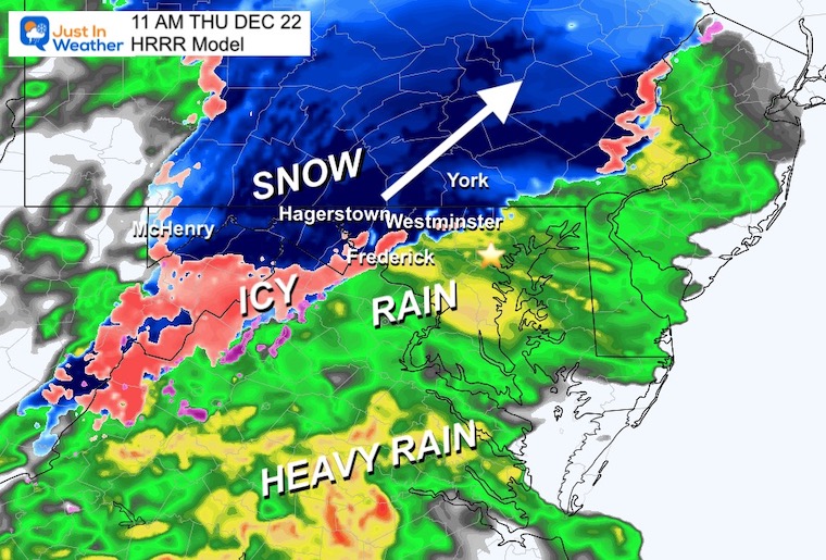
I would share the same concern for Northern Baltimore and Harford counties in Maryland to Southern Pennsylvania through York and Lancaster.
Flood Watch for metro Counties along the western shore of the Bay.
Coastal Flood Advisory off the Atlantic Beaches.
High Winds And Wind Chill Advisories are for Friday and I expect more will be added for the rest of our region.
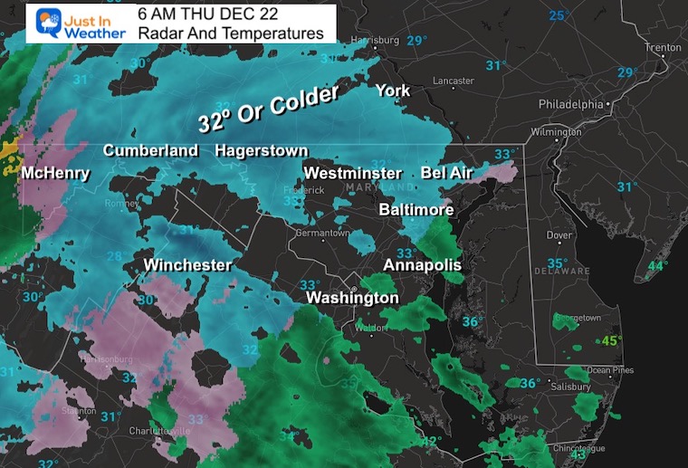
I’ve highlighted the freezing line in blue. These are areas that may get icy when this precipitation moves in.
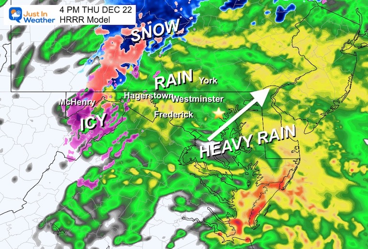
This is Part 1 of the storm and is just beginning to fill in on the radar. We are on the fine line between snow and ice inland, to just a cold rain for the cities near the Bay and Delmarva.
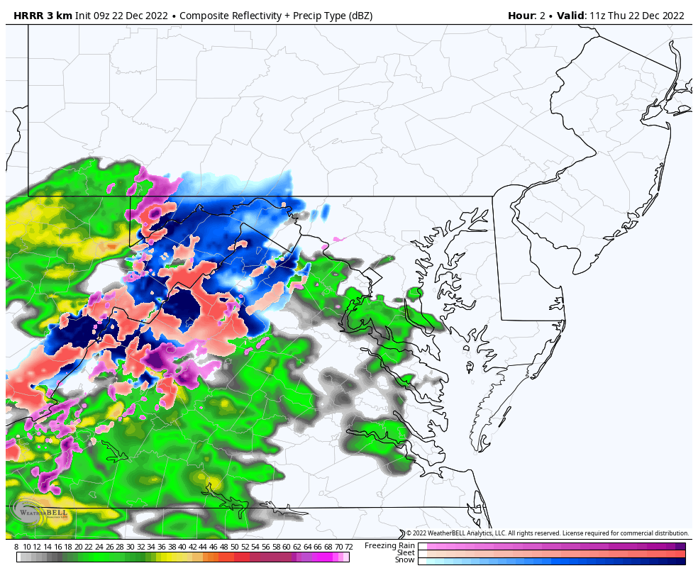
6 AM to 4 PM HRRR Model
This is the best model we have and it was missing the light snow and sleet at 5 and 6 am, so it’s hard to tell how well it will handle the rest. But it does show snow and ice impacts for the same counties I mentioned above.
In Maryland, Howard and Carroll County were added. It is possible not all of the counties get slick, but parts of them will.
I would share the same concern for Northern Baltimore and Harford Counties in Maryland to Southern Pennsylvania through York and Lancaster.
Part 2: The Arctic Blast is producing a blizzard in the Great Lakes today. It will reach us EARLIER on Friday Morning.
Due to my limited time, these are maps I shared last night. I will have an update on the specific timing later.
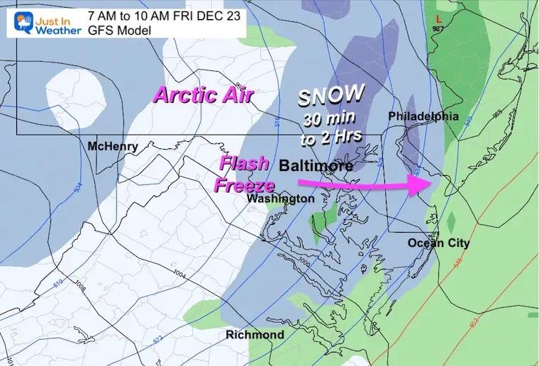
The main issue is that THE FLASH FREEZE is very likely and will arrive BEFORE NOON. In fact, metro areas may get it by 9 AM to 10 AM.
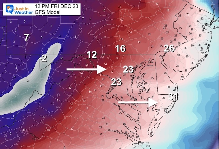
Let’s Focus On The Temperatures, because the snow will be minimal.
The arrival of the arctic air keeps getting sooner.
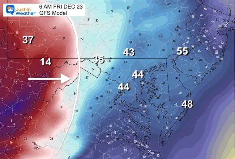
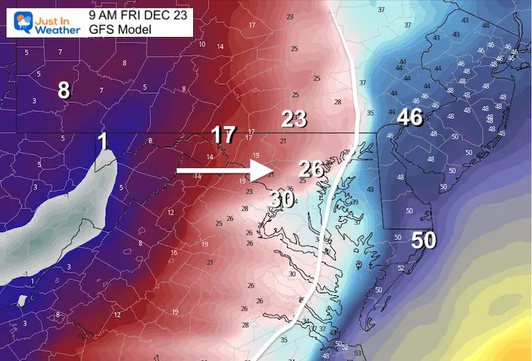
7 AM to 10 AM Summary
Snow may only last a half hour to up to 2 hours. It’s not the accumulation, it’s the support for wet roads to freeze that is the big story!
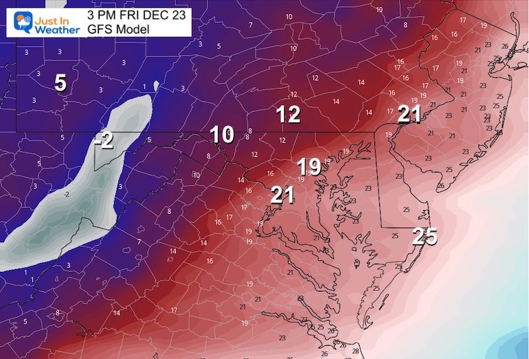
The freezing line now reaches the coast by noon, while Baltimore drops to the lower 20s and teens to below zero farther west.
It might be hard to believe this is real, and even if it’s over zealous, it will be getting very cold in a hurry!
This will be painful without question. I expect Wind Chill Advisories for some of the area given these numbers.
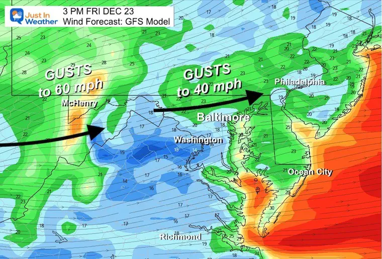
Yes, that is -29ºF for McHenry. Barely +3ºF for Baltimore.
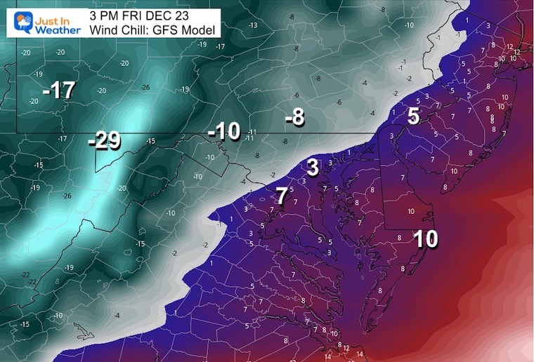
The winds will be ferocious with gusts in metro areas to 40 mph and up to 60 mph in the mountains. I expect there may be some wind advisories and wind chill advisories issued for Friday into Saturday morning.
That’s it for now. I’ll be up early to see if “stuff” is advancing or not.
In my prior report I answered two common questions about this event. Both will be validated over the next few days.
In short, a storm is low pressure, and a deeper storm has lower numbers of atmospheric pressure we measure in millibars (mb). When a storm gets stronger, the mb are lower numbers, which we say are ‘dropping’.
A Bomb Cyclone is defined as a storm dropping more than 24 mb in 24 hours, or more than 1 mb per hour for a day. See my report here for the maps that prove this.
This is when arctic air arrives and turns wet pavement to ice. We expect temperatures to drop midday Friday. The challenge is if pavement will remain wet as the temps drop, to allow ice to form on roads. Or, will the cold wind evaporate that wet pavement, drying up before it has a chance to freeze.

December 5th Snow In Baltimore And The Start Of Faith In The Flakes FITF

Click to see more and ‘Book’ a visit to your school

I see many factors to support colder influence with multiple systems. Early and later in winter. Check it out.
Winter Outlook 2023 For Snow Not Typical La Niña Plus Polar Vortex Disruption
Atmospheric Memory Suggests Active Winter Storm Pattern Outlook
Winter Outlook 2023 From NOAA Very Different Than Farmers Almanacs
Winter Outlook 2023 Early Look At Snow From Two Farmers Almanacs
If you want a snowy winter, this is what you might want to look for in the rest of the tropical season. (You might be seeing a lot of commercial snow removal people out this Winter).
Record August For No Named Tropical Storms: Closer Look At Snow Following
Winter Weather Folklore Top 20 And More Outlook Signals From Nature For Cold And Snow
