


May 1 Weather Gradual Cooling Trend Will Bring Rain Into The Weekend
Wednesday, May 1 Morning Report One of the marks of May Day is an ancient European holiday celebrating the start of summer. It feels like we have had our taste…
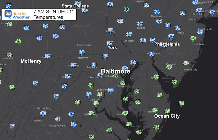
December 11 2022
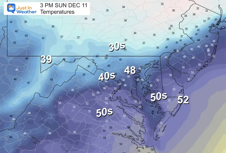
Sunday Morning Update
I found out this morning that my wife programmed her Alexa to announce if it is snowing or not every morning! She and I have a different view on snow, and this morning it is the way she wants. I didn’t really expect us to have an issue, but I know there has been some concern. In short, we do NOT have snow this morning locally.
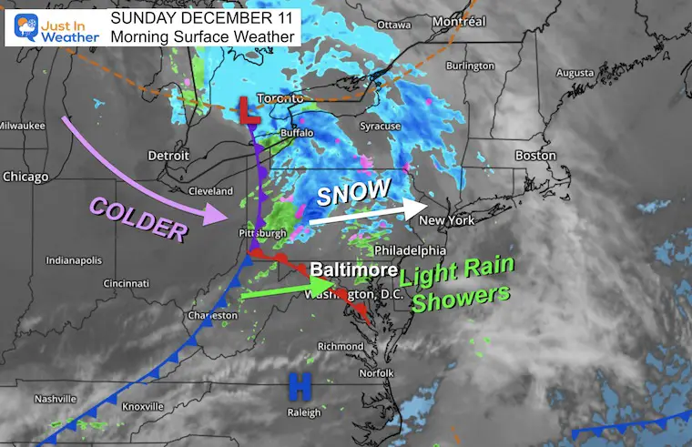
A little weather system today has brought us primarily light rain showers. The snow is located well north and if you are traveling into PA any impact might be near and north of I-78 and I-80. This may include State College to Allentown and Scranton. But wait, more winter ‘stuff’ is on the way.
If you are doing light traveling to church or a day trip, we are safely above freezing from the far western Maryland mountains, even into southern PA.
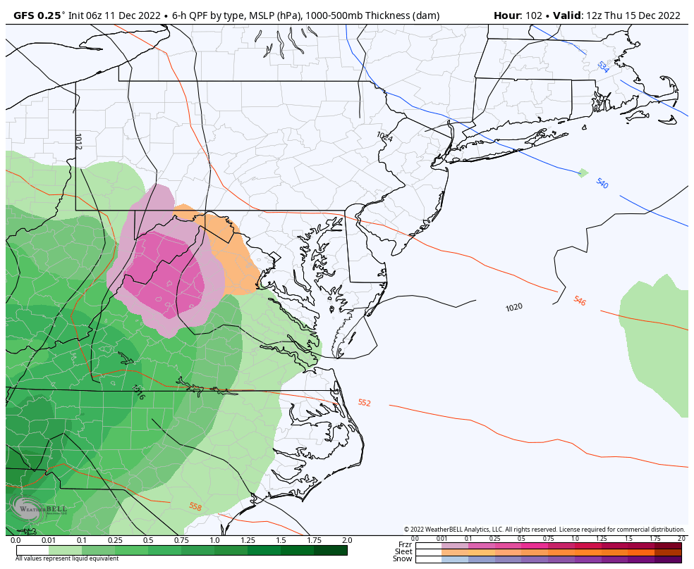
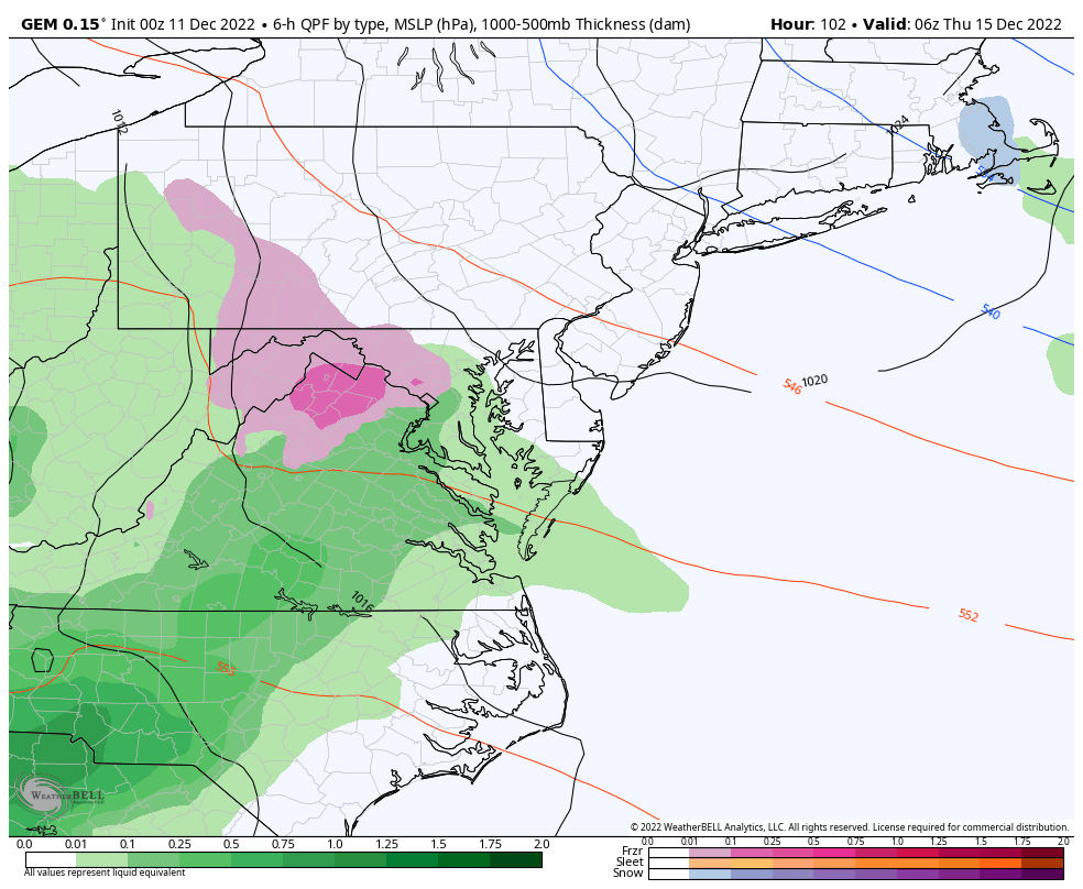
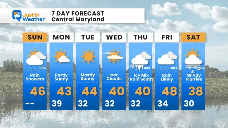
The winter storm this week is looking like Thursday evening with an icy mix. The latest models are in more agreement with the track Friday, followed by a colder finish. See the comparison below.
Our temperatures remain below average, but the really cold air is about to make a shift especially into Christmas Week with the wobbling of the Polar Vortex.
Chilly but NOT Freezing
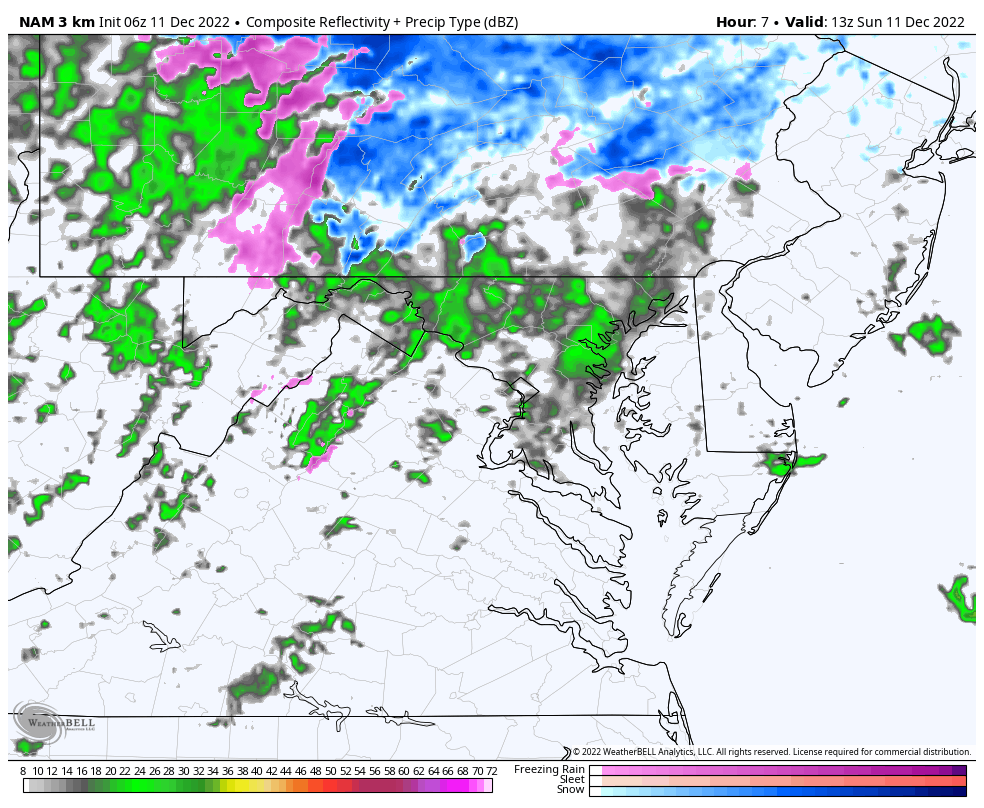
This is a small storm system with most of the energy tracking across central Pennsylvania. Rain showers extend into central Maryland and southern Pennsylvania. The snow part of this is north of Harrisburg, where some minor stickage is possible across the Poconos.
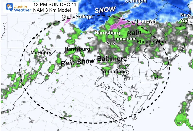
Rain showers through early afternoon. We tend to see systems move out a little faster than shown here.
Rain showers will be widespread midday. I’ve added cities to show where the snow is more likely into north central PA and metro New York.
Use the controls to interact and pan or zoom the view.
These are below average and will feel colder with increasing clouds.
Normal Low in Baltimore: 31ºF
Record 9ºF in 1958
SNOW: 9.3 inches in 1960
Normal High in Baltimore: 49ºF
Record 70ºF 2021
NEW REPORT
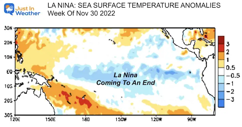
La Niña Forecast To End This Winter: Boosting Snow Odds
Back into colder air behind the weather system.
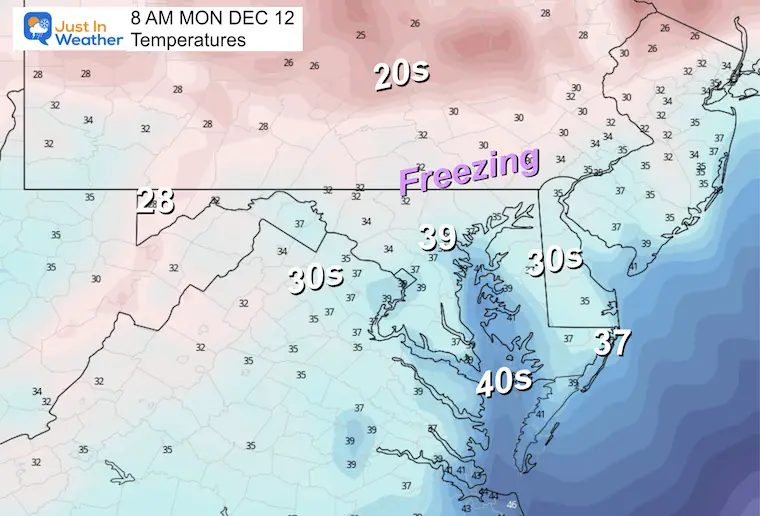
Mix of clouds and sunshine as we remain chilly.
The trend I have seen since yesterday has been more agreement with both the start time and precipitation type. At this point it looks like this:
An icy wintry mix will develop close to sunrise. I do not like to pin down the type without knowing the depth of the cold air. But this looks like an overrunning event with warm air at cloud level catching up to cold air at the surface. The result may be this: Morning icy mix
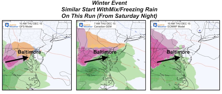
The Low tracks farther north bringing in warmer air later in the day pushing most of the area to rain. The GFS is the colder solution now with snow near the Maryland and Pennsylvania line, while the others bring in all rain for the Mid Atlantic.
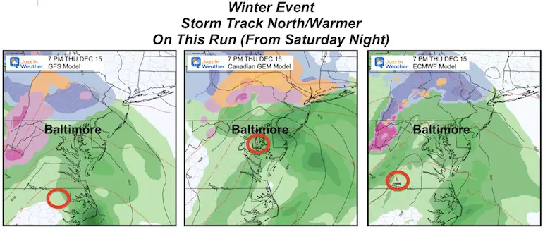
This has a later start (after sunrise) with freezing rain and slushy snow. By evening, a brief period of snow near the Maryland/Pennsylvania line as metro areas turn to rain. Then all rain Friday, followed Saturday snow showers or flurries with colder winds.
This model starts Thursday morning with freezing rain by sunrise. Then changes to all rain by the evening, with the Low tracking through central Maryland. As the Low cranks in New England, we get dry, colder air to cut the storm off sooner. However, snow showers off the Great Lakes will extend into the mountains.
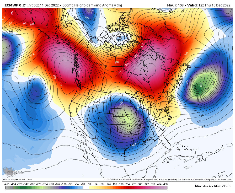
The European Model shows the colder air with the end of week storm, followed by a profound adjustment in the Polar circulation, thanks to a strong Greenland Block. We can see the overwhelming colder air (blue and green shades) expanding southward through central Canada into the Eastern US Christmas week.
Faith in the Flakes.
Please note these temperatures are for Baltimore. It is often colder inland to the west and north.
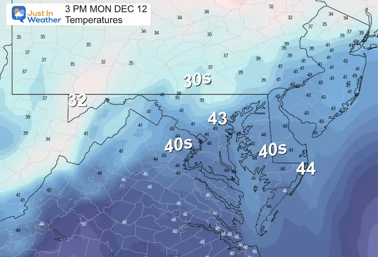
While dry, we remain below average early in the week. The storm (still subject to change) is looking like an icy start then turning to rain Thursday night, with Friday most likely rain. Any change in track can dramatically shift this.


Click to see more and ‘Book’ a visit to your school

I see many factors to support colder influence with multiple systems. Early and later in winter. Check it out.
Winter Outlook 2023 For Snow Not Typical La Niña Plus Polar Vortex Disruption
Atmospheric Memory Suggests Active Winter Storm Pattern Outlook
Winter Outlook 2023 From NOAA Very Different Than Farmers Almanacs
Winter Outlook 2023 Early Look At Snow From Two Farmers Almanacs
If you want a snowy winter, this is what you might want to look for in the rest of the tropical season. (You might be seeing a lot of commercial snow removal people out this Winter).
Record August For No Named Tropical Storms: Closer Look At Snow Following
Winter Weather Folklore Top 20 And More Outlook Signals From Nature For Cold And Snow
