December 1 Winter Begins With Chilly Breeze
December 1 2022
Thursday Morning Update
As we start this brand new month, it is the start of meteorological winter. The wind will not be as strong as yesterday (even though some mentioned it wasn’t bad then), but it will be noticeable with the colder air.
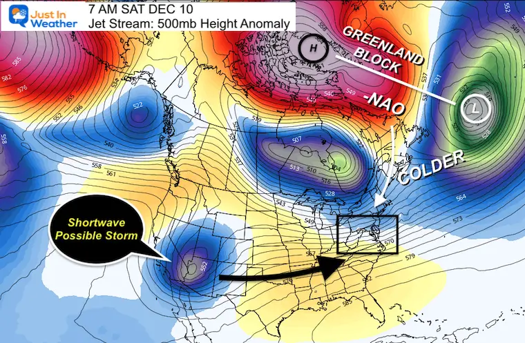
Our cycle of rain and wind every 3rd day will continue, so next up will be Saturday, then colder on Sunday. If you missed my look ahead, the pattern change is on the way by the end of next week, and I will share that link below. But first, the current weather.
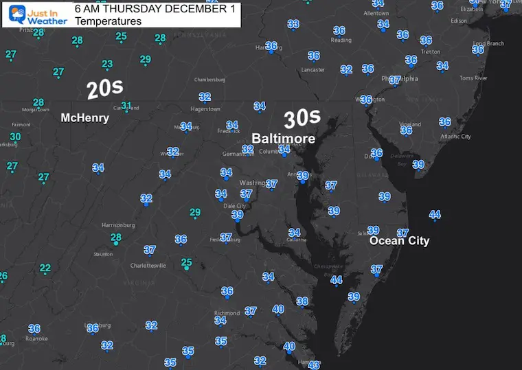
Morning Temperatures
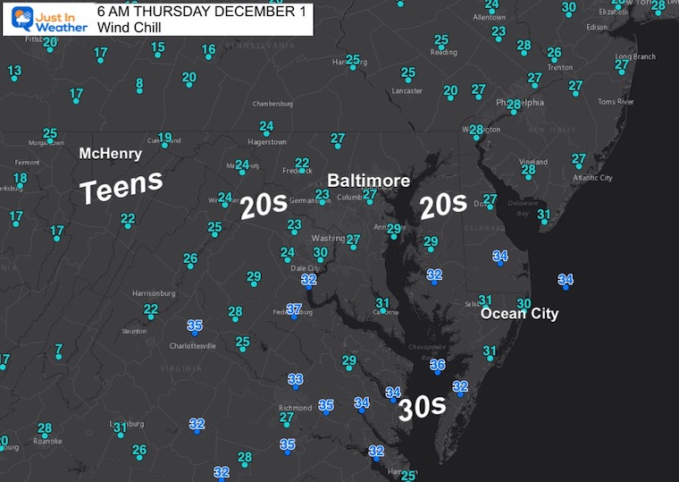
Widespread 30s are reported through metro areas and across the Bay. The 20s are in the higher mountains and west towards Pittsburgh.
Wind Chill
Winds are 5 to 10 mph at this time, but expected to increase after sunrise with typical daily mixing. That will keep wind chills low.
Morning Surface Weather
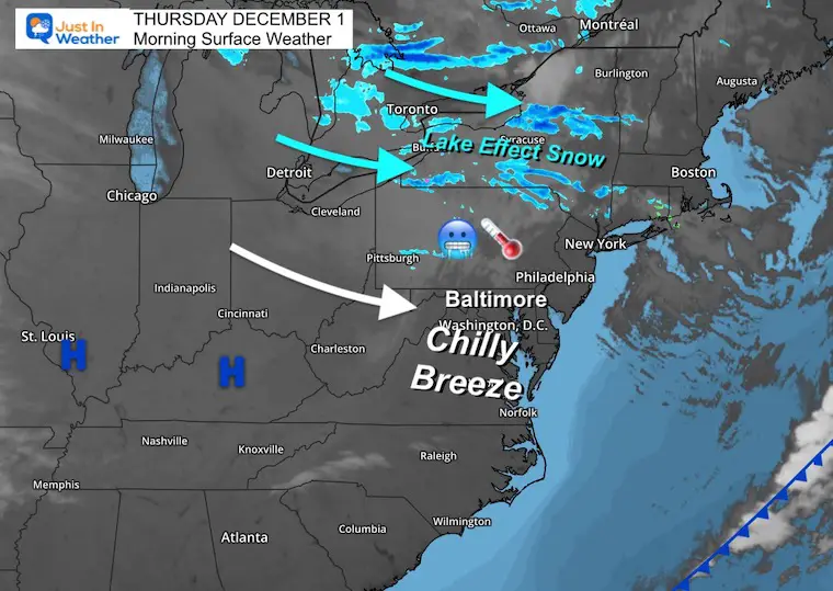
Those strong winds ignited some Lake Effect Snow showers across New York and Pennsylvania. Flurries even reached metro Philadelphia, but didn’t amount to much. The more pronounced snow is across the Finger Lakes region of Central New York.
Headlines
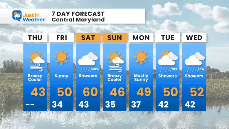
- Today: Chilly and Breezy. Wind Chills noticeable through the afternoon.
- Tomorrow: Sunny and mild.
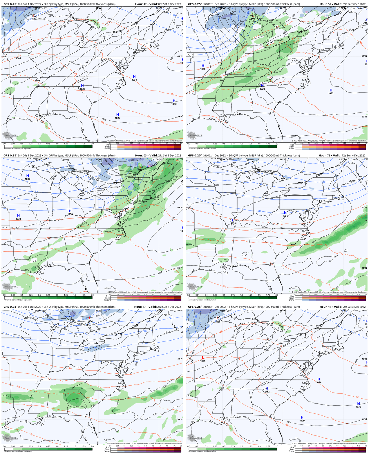
- Weekend: Saturday rain showers, Sunday windy and chilly.
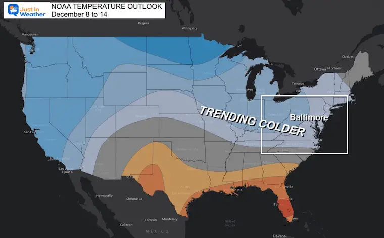
COLD Pattern Change (Click Images For The Report)
NOAA Outlook joins the party with COLDER TREND
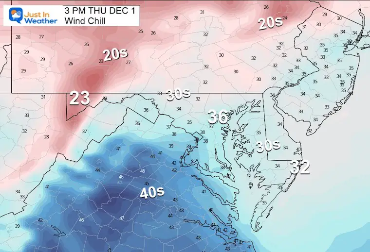
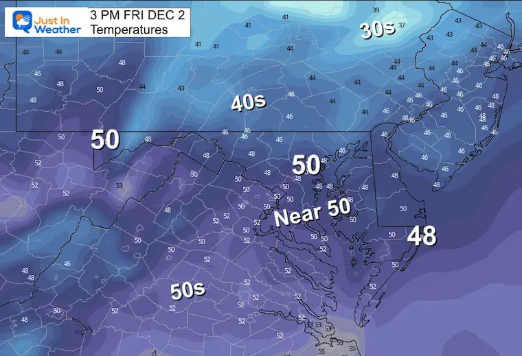
3 PM Temperatures
Temps will be much cooler than yesterday and when the wind gets added in, it will feel even colder.

Wind Chill
Brisk winds will make it feel like the 30s for most of the region east of the mountains.
Subscribe to my Newsletter
Weather posts straight to your inbox
Sign up and be the first to know!
CLIMATE DATA
TODAY December 1
Normal Low in Baltimore: 33ºF
Record 12ºF in 1967
SNOW: 1.5 inches in 1903
Normal High in Baltimore: 52ºF
Record 75ºF 2006
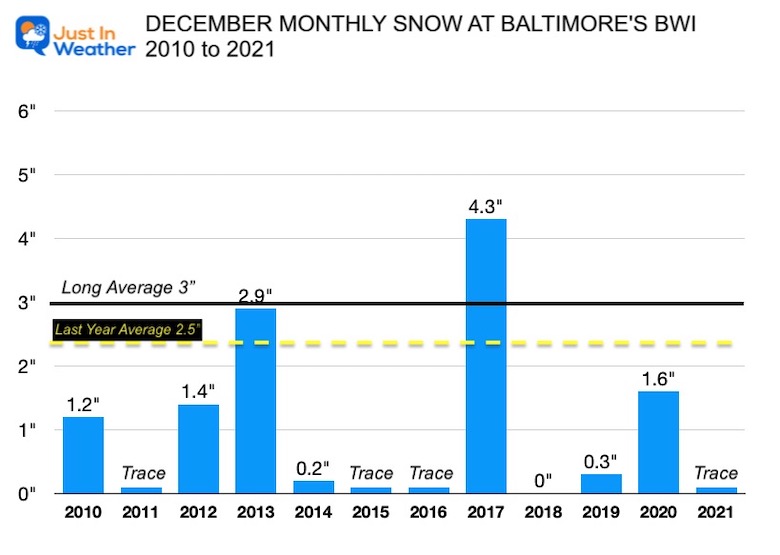
December Snow In Baltimore Since 2010
NEW REPORTS:
Record Snow Cover Across The Northern Hemisphere
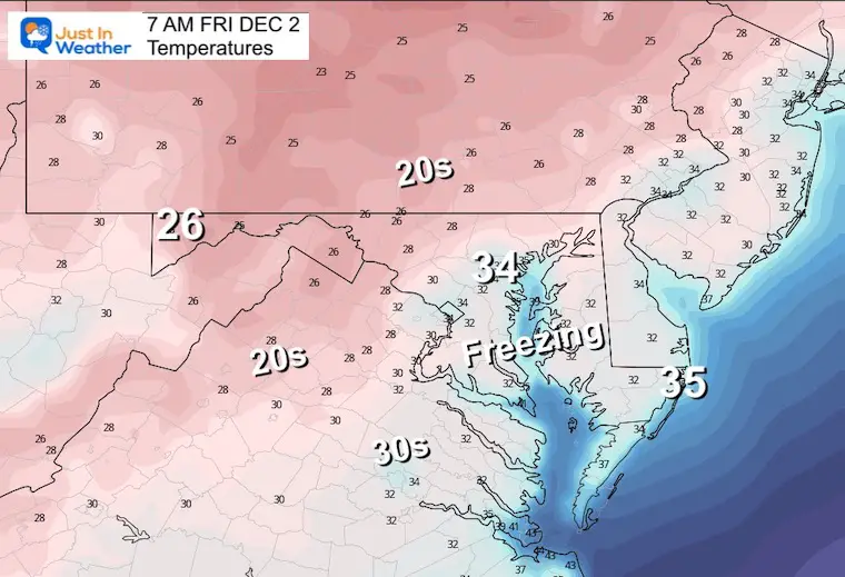
Friday Temperatures
Morning
Colder air settles in as the wind dies down.
Afternoon
With sunshine and lighter winds, temps rebound to near 50ºF.
Saturday Rain
GFS Model Friday Night To Sunday Afternoon
7 Day Forecast
NEW Faith In The Flakes Gear
https://shop.justinweather.com/
My Winter Outlook: Not A Typical La Niña!
I see many factors to support colder influence with multiple systems. Early and later in winter. Check it out.
October 27 Nor’easter Recap Still Breezy Then Next Storm Friday
Also See The Winter Outlook Series:
October 27 Nor’easter Recap Still Breezy Then Next Storm Friday
Farmer’s Almanac Comparison
September Starts Meteorological Autumn: Weather Climate Stats For Maryland at Baltimore
Triple Dip La Niña Winter
CONNECTION TO WINTER?
If you want a snowy winter, this is what you might want to look for in the rest of the tropical season. (You might be seeing a lot of commercial snow removal people out this Winter).
Rainbow Ice Cave In Mt. Rainier A Very Rare Find: Photos And Video
Wooly Bear Caterpillars
https://justinweather.com/2022/10/25/winter-weather-outlook-from-the-wooly-bear-caterpillar/
Persimmon Seeds
Click to see Top 20 and MORE
Winter Weather Folklore Top 20 And More Outlook Signals From Nature For Cold And Snow
Faith in the Flakes Gear
SNOWSTIX – Available Now
Normals And Records: Maryland and Baltimore Climate History
STEM Assemblies/In School Fields Trips Are Back
Click to see more and ‘Book’ a visit to your school
Please share your thoughts, best weather pics/videos, or just keep in touch via social media
-
Facebook: Justin Berk, Meteorologist
-
Twitter: @JustinWeather
-
Instagram: justinweather


