Thursday Night Update
December 1 2022
There is a lot of excitement within the weather community about what may unfold over the next two weeks. But are you familiar with the expression of ‘too much of a good thing’? The more I see, and share with you, makes me also want to add in this element. Not so much that it will be ‘too cold to snow’, but it could relate to too cold to know how a storm track may set up.
The weather pattern is expected to take a significant winter turn to cold and possibly snowy. The prime target now seems to be between December 9 and 15.
What I have been sharing with you is an attempt to simplify the noise, but trust me there is a lot of chatter. The dogs (weather snow hounds) are howling at the prospects of a record low Negative North Atlantic Oscillation (-NAO). That is a measure of a blocking weather pattern that can send arctic air from Greenland to the Eastern Unites States.
New research I read today reminded me of something I wanted to play up in my prior report.
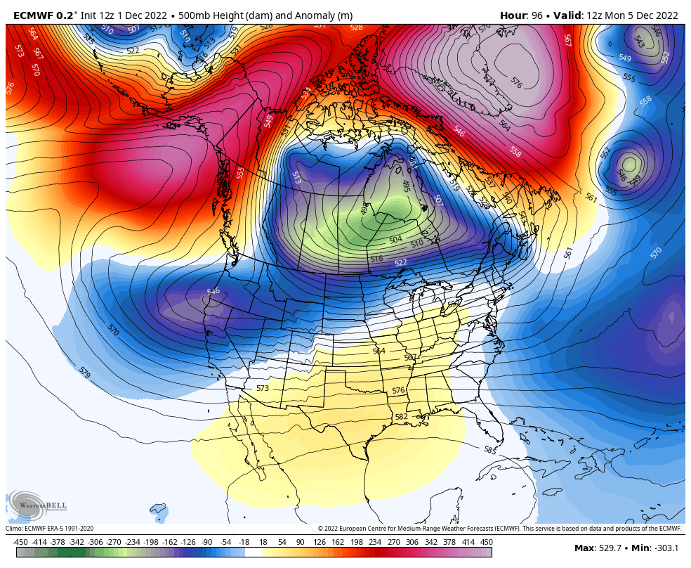
Check this out:
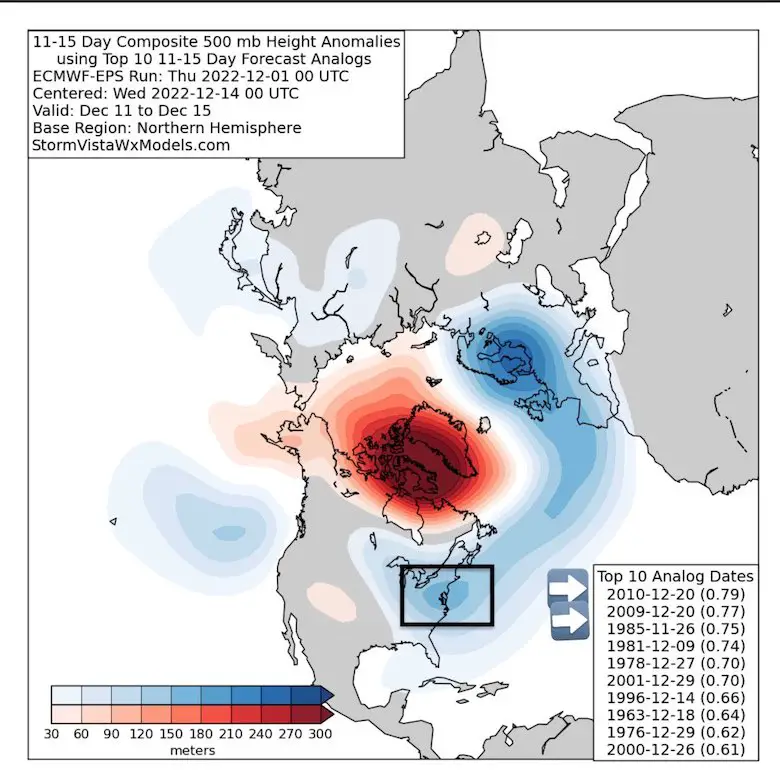
Mike Thomas @MikeTFox5 posted this image today.
The most valuable info was his note “But have to stay grounded”
I agree, and this was in line with Dr. Judah Cohen’s blog I shared in my prior report.
He showed that the expected Jet Steam 500mb Height Anomalies correlated best with
- 1st: December 2010
- 2nd December 2009
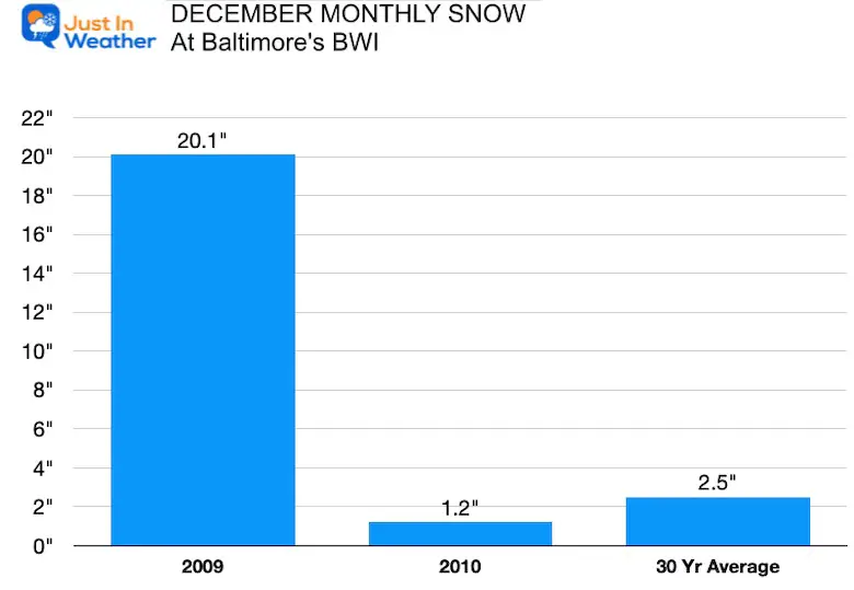
What That Meant In Baltimore
Both years brought snow! However, the stronger 2010 event brought much less snow. Too much of a good thing!
The 2009 winter was a close 2nd place, and the result was ridiculous.
The two similar December snowfalls ranges from 1.2″ to 20.1″. Just as easy as switching the digits and moving a decimal place, right? If only, but it does show a good chance for some snow. However it does not promise a lot. Just keeps it in the running.
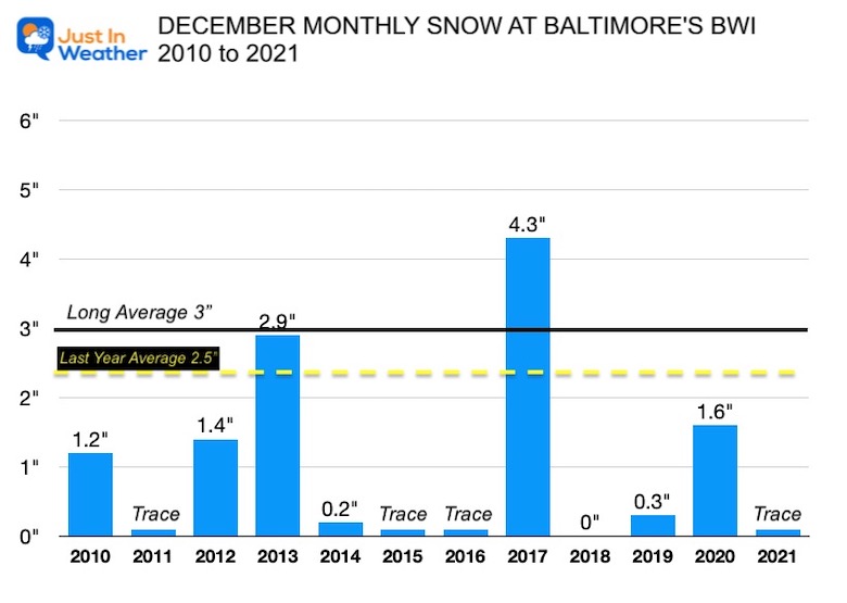
Reminder: December Snow Past Decade
Since the start of the last decade:
- 11 of the last 12 years there has been at least a trace of snowfall.
- 5 years had over 1 inch of snow, about 42% of the time.
- Only 1 year had nothing!
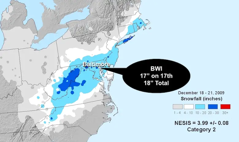
December 2009 Storm
In Baltimore, this event kicked off our record 3 blizzard winter. It was also controversial because Baltimore City and other municipalities needed a 20 inch snow total to get federal funding for the impact on commerce and clean up. This one fell just short. On the 17th there was 17 inches at BWI, and a storm total of 18 inches. The total for the entire month was 20.1″, which was second to 20.4″ in 1966. That happened to nearly match an average total season for snow.
Do you remember the two blizzards between Feb 5 and Feb 10 in 2010? That season resulted in an all time high of 77 inches for Baltimore.
Explore More:
December Outlook Trending Colder For Start Of Meteorological Winter
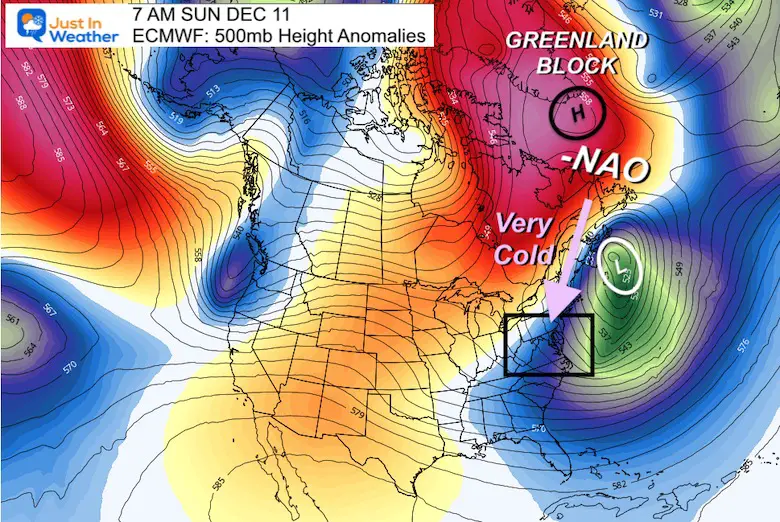
Evolving Greenland Block
and NEGATIVE DIVE of the North Atlantic Oscillation
Snapshot December 10
By the end of NEXT WEEKEND, we should see our winter weather make a move. That Greenland Block will be in place, sending arctic air into the Mid Atlantic.
The question still remains the surface weather reflection.
I DO NOT trust synoptic storm maps beyond 7 days, and if you see them from any other place, RUN!
As I mentioned in my prior report, I would rather NOT see a storm show up until sooner. Those week ahead events often do not play out.
This Global Weather Scale Pattern however does has a higher confidence that far ahead.
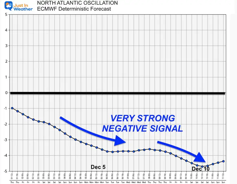
European Model ECMWF NAO Forecast
This is still trending very deep into negative territory. It has pulled back a little from the -5 mark a few days ago, but I will be watching as we get closer for the -4 to -5 range.
There is a lot more significance to that 2009-2010 winter, which I will share in a report this weekend. For now, it is still looking like we will turn cold and have an increased chance to get our first snow before Christmas.
Faith in the Flakes #FITF
Faith in the Flakes Gear
SEE NEW ITEMS THIS YEAR

NEW REPORTS:
Record Snow Cover Across The Northern Hemisphere
Snow Cover Now At 56 Year High In The Northern Hemisphere
December Pattern Change
How The Winter Weather Pattern May Develop In Early December
My Winter Outlook: Not A Typical La Niña!
I see many factors to support colder influence with multiple systems. Early and later in winter. Check it out.
Winter Outlook 2023 For Snow Not Typical La Niña Plus Polar Vortex Disruption
Also See The Winter Outlook Series:
Atmospheric Memory Suggests Active Winter Storm Pattern Outlook
Winter Outlook 2023 From NOAA Very Different Than Farmers Almanacs
Farmer’s Almanac Comparison
Winter Outlook 2023 Early Look At Snow From Two Farmers Almanacs
Triple Dip La Niña Winter
Winter Outlook 2023 La Niña Triple Dip Expectations
CONNECTION TO WINTER?
If you want a snowy winter, this is what you might want to look for in the rest of the tropical season. (You might be seeing a lot of commercial snow removal people out this Winter).
Record August For No Named Tropical Storms: Closer Look At Snow Following
Wooly Bear Caterpillars
Winter Weather Outlook From The Wooly Bear Caterpillar
Persimmon Seeds
Winter Weather Outlook: Persimmon Seeds And Snow Folklore
Click to see Top 20 and MORE
Winter Weather Folklore Top 20 And More Outlook Signals From Nature For Cold And Snow
SNOWSTIX – Available Now

Normals And Records: Maryland and Baltimore Climate History

STEM Assemblies/In School Fields Trips Are Back
Click to see more and ‘Book’ a visit to your school

Please share your thoughts, best weather pics/videos, or just keep in touch via social media


