


Average Last Frost or Freeze Dates And Map For Maryland
There is a good reason why many gardeners suggest NOT to plan tomatoes until after Mother’s Day. Early surges of warm air in spring can be deceiving. Just because the…
November 17 2022
Thursday Update
The big weather event of the week is the expected historic Lake Effect Snow event for Buffalo. Cold air over the large body of water from Lake Erie (and the other Great Lakes) has been known to produce a few feet of snow in a few days. The city of Buffalo is a moderately sized metropolitan area that is situated on the northeast corner of Lake Erie and the precise wind direction can make or break where the heaviest snow piles up.
More on the forecast AND how lake effect snow forms below.
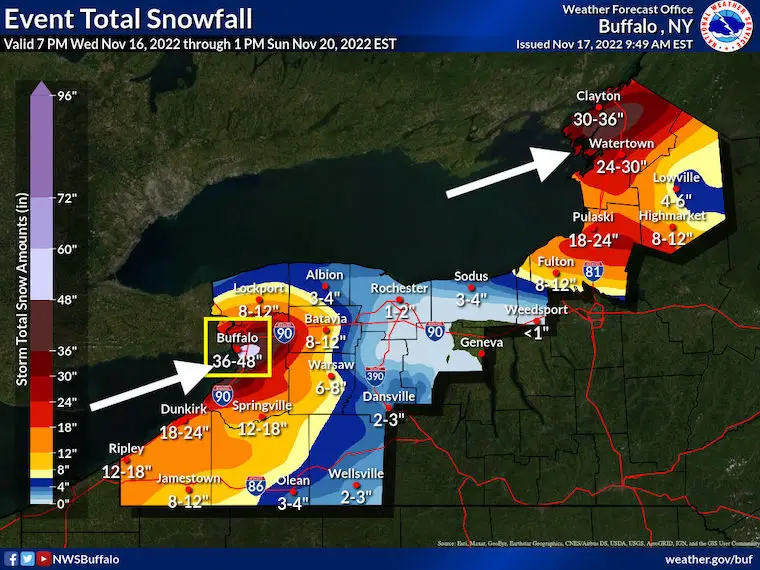
Historically the Lake Effect Snow Bands have set up just south and east of Buffalo. Hitting the city hardest is rare, but has happened. Here are the top 10 events over three days.
It was exactly 8 years ago when a similar event formed, but the snow band was 10 miles away from downtown Buffalo.
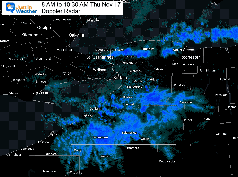
Doppler Radar 8 AM to 10:30 PM
The snow that has been falling is NOT the main event. This has been with a Northwest Wind, piling snow south of the city.
This sets the tone for seriousness
Where the lake effect is the most intense and persistent, snow will be measured in feet, not inches. Travel within these bands will be extremely dangerous, if not impossible. This will especially be the case across the Buffalo Metro Friday and Friday night. pic.twitter.com/49mLsqLX6T
— NWS Buffalo (@NWSBUFFALO) November 16, 2022
The forecast shows the wind shift, which will swing to the West-Southwest. That is where the long fetch across Lake Erie will align to dump near or in Buffalo.
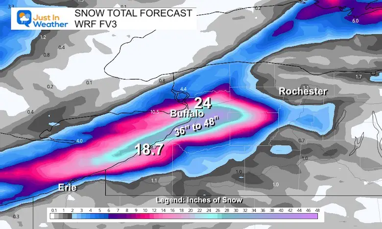
It is important to note that snowfall rates of 2 to 4 inches per hours are possible. So if a band sits over the same area with little oscillation, that can easily bring 36” to 48” of snow.
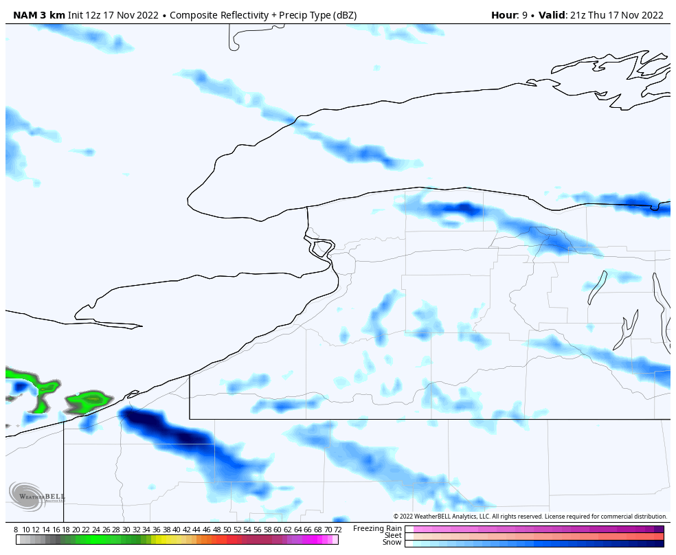
NAM 3 Km Model – 4 PM Thu to 7 PM Sun
GFS Model – 4 PM Thu to 7 PM Sun
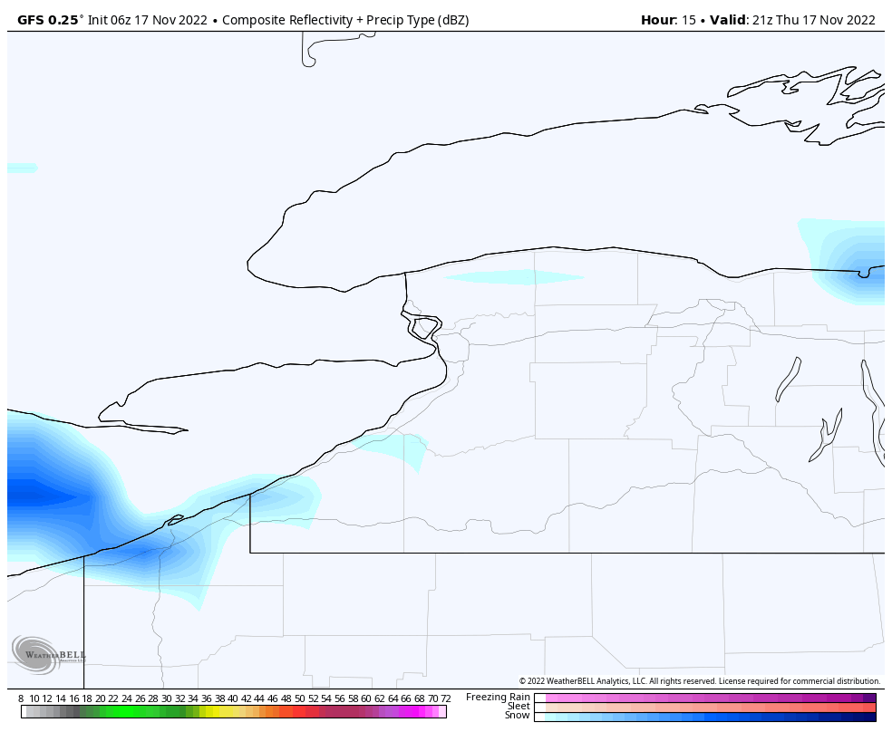
The models often underplay the potential, so compare this to the local National Weather Service Office Map
WRF-FV3
Orchard Park is where the Buffalo Bills play, which is south of Buffalo City. They have a home football game this Sunday against the Browns. Not only may snow still be falling, but they may be digging out from as much as 4 feet of the white stuff.
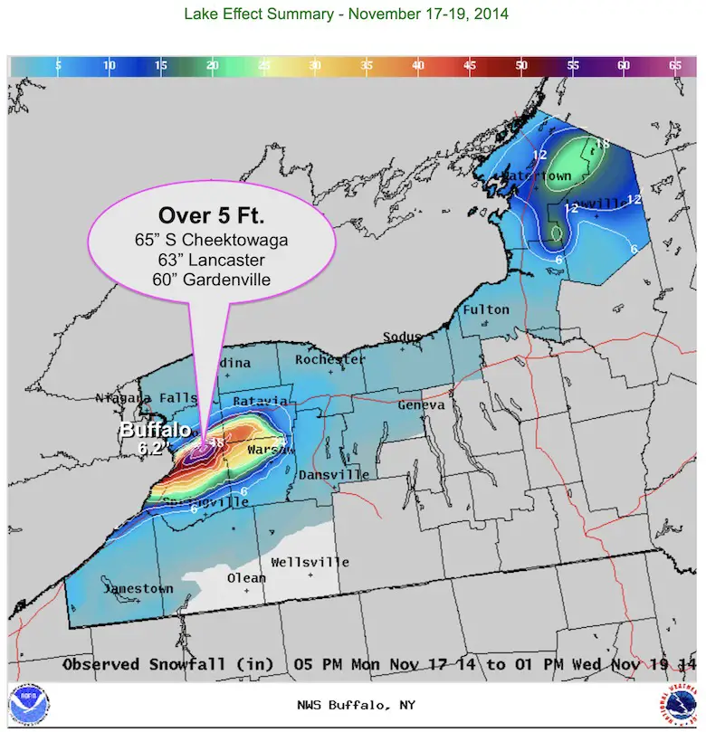
The location of Great Lakes along the border of Canada and The United States is situated perfectly for the local weather phenomenon known as Lake Effect Snow. What is setting up now near Buffalo, NY may rival some of the top events. If nothing else, a few feet of snow expected would make this maybe the most since a similar November Lake Effect Snow Event in 2014.
From The National Weather Service:
”Winter has no plans for subtlety across the snowbelts of upstate NY! Multiple FEET of lake-effect snow are expected through this weekend across the region including the Buffalo and Watertown metro areas”
More on that event and current forecast below.
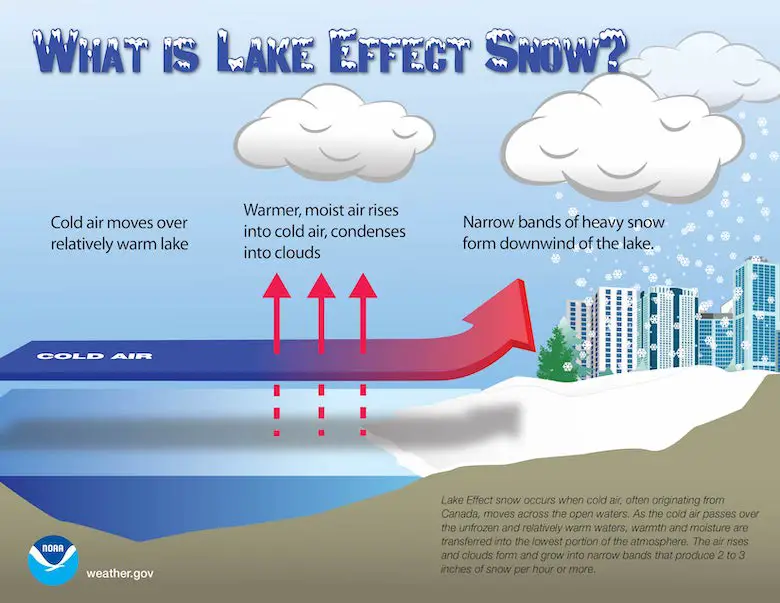
What Is Lake Effect Snow
Cold air from Canada blowing across the large bodies of fresh water allow for a ‘fetch’ to pick up moisture and develop a band of rain or snow downwind. In the winter, this can produce a narrow and very intense band of heavy snow which can include many inches per hour and even lightning and thunder. The results can pile up many FEET of snow in just a few days!
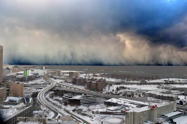
This photo from Buffalo looking out across Lake Erie shows a wall of snow in a band over the water. It is common to go from partly cloudy to white out conditions on the other side.
On a side note, this has happened before. During December 14-18, 1945. The airport measured nearly 37 inches, and in excess of 70 inches fell just 4-6 miles south (Lancaster).
See the full report for this event from The National Weather Service in Buffalo
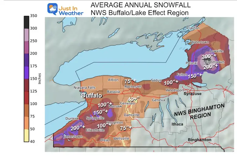
Lake Effect snow is a way of life, where the cities such as Cleveland, Buffalo, Rochester, and Syracuse can range from 80 to over 110 inches of snow in a normal winter. Some of the outlying areas can average over 200 inches of snow, especially where the wind lines up routinely from the nearby lakes.
Side note: My first TV job was in Syracuse at WSTM. That city averages more snow, but Buffalo is a larger city and gets more press.
Two ways to get notified more often:
Sign Up For My Newsletter
ALSO on Facebook
They keep changing the settings… Go to my page wall and click this button to mark it as *Favorites
Click this image to get to my page wall


Winter Outlook 2023 From NOAA Very Different Than Farmers Almanacs
Winter Outlook 2023 Early Look At Snow From Two Farmers Almanacs
If you want a snowy winter, this is what you might want to look for in the rest of the tropical season. (You might be seeing a lot of commercial snow removal people out this Winter).
Record August For No Named Tropical Storms: Closer Look At Snow Following
Winter Weather Folklore Top 20 And More Outlook Signals From Nature For Cold And Snow

Click to see more and ‘Book’ a visit to your school
