


July 18 Flood Watch In The Mountains Then Storms Expand Back This Weekend
Friday, July 18 2025 Morning Report There is some relief in sight, but I remain cautious. For the short term, today remains muggy, while the focus of strong storms and…
November 16 2022
Wednesday Evening Update
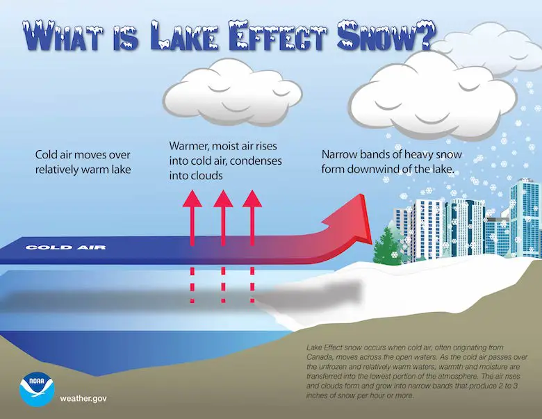
The location of Great Lakes along the border of Canada and The United States is situated perfectly for the local weather phenomenon known as Lake Effect Snow. What is setting up now near Buffalo, NY may rival some of the top events. If nothing else, a few feet of snow expected would make this the most since a similar November Lake Effect Snow Event in 2014. The totals could amount to nearly half of what a normal season brings them.
”Winter has no plans for subtlety across the snowbelts of upstate NY! Multiple FEET of lake-effect snow are expected through this weekend across the region including the Buffalo and Watertown metro areas”
More on that event and current forecast below.
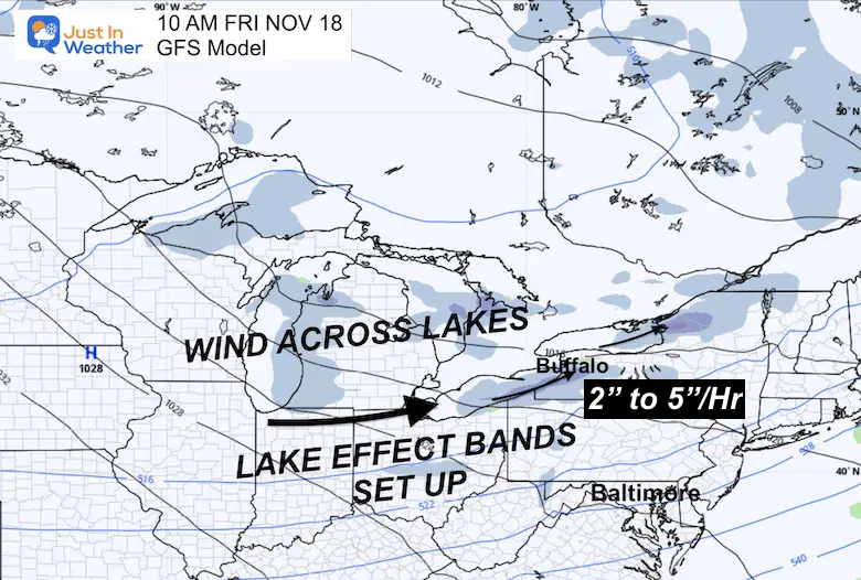
Cold air from Canada blowing across the large bodies of fresh water allow for a ‘fetch’ to pick up moisture and develop a band of rain or snow downwind. In the winter, this can produce a narrow and very intense band of heavy snow which can include many inches per hour and even lightning and thunder. The results can pile up many FEET of snow in just a few days!
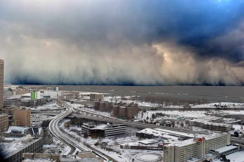
This photo from Buffalo looking out across Lake Erie shows a wall of snow in a band over the water. It is common to go from partly cloudy to white out conditions on the other side.
Early season arctic outbreaks such as the one on the way now maximize the energy with the lakes still relatively warm resulting in excessive moisture available. As the water cools, the events become less intense and even can shut off when the water freezes.
It was almost exactly 8 years ago when an similar event produced:
Wide Range In Short Distance
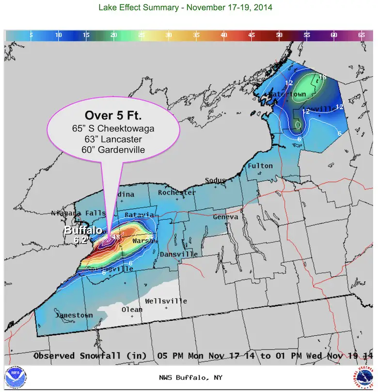
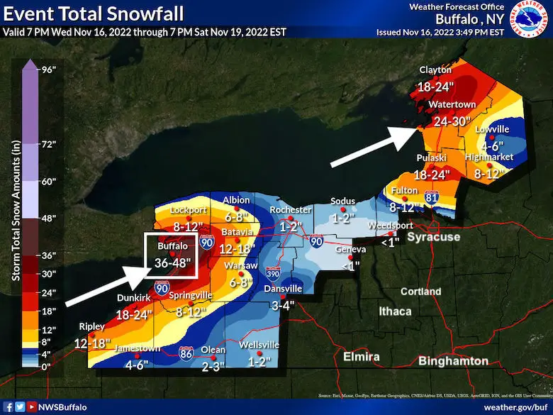
On a side note, this has happened before. During December 14-18, 1945. The airport measured nearly 37 inches and in excess of 70 inches fell just 4-6 miles south (Lancaster).
See the full report for this event from The National Weather Service in Buffalo
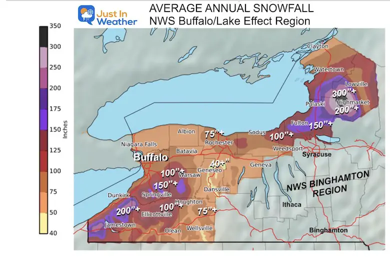
Lake Effect snow is a way of life, where the cities such as Cleveland, Buffalo, Rochester, and Syracuse can range from 80 to over 110 inches of snow in a normal winter. Some of the outlying areas can average over 200 inches of snow, especially where the wind lines up routinely from the nearby lakes.
Side note: My first TV job was in Syracuse, at WSTM-TV3. That city averages more snow, but Buffalo is a larger city and gets more press.
This map is just for the immediate Lake region in New York State covered by NWS Buffalo.
The event on the way is poised to set up between today (Wednesday, November 16) and Sunday. That is 5 days in a row with some areas getting persistent snow over 2” per hour.
This may include Buffalo. I say ‘may’ because the wind direction and narrow band can sometimes set up just south and meander near or around the city itself.
There is no organized storm system. This is simply a large cold air mass with winds flowing over the great lakes. A large ‘fetch’ over the longest part of the lake is what will pick the moisture. Then the precise direction of the wind will determine exactly where the band will set up.
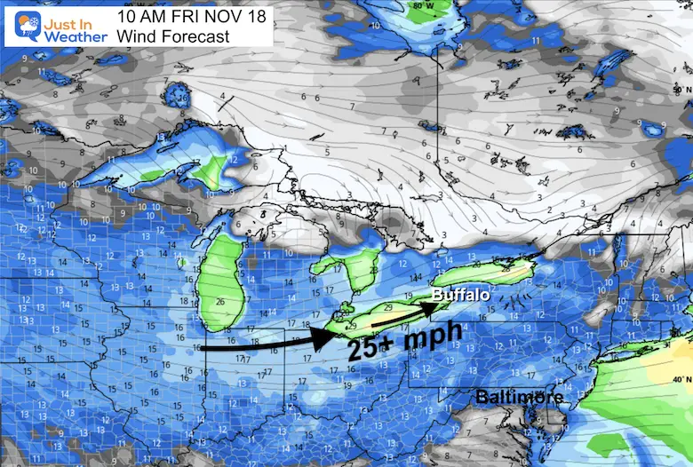
That is a very hard part of the forecast. Imagine only 10 miles could separate a few inches from a few feet of snow.
8 PM WED to 4 PM SUN
This is a rough estimate of the snow bands every 3 hours. It may come in pulses, and meander north and south.
Note: More snow often falls south and east of Buffalo. Also, this event should be winding down by Sunday afternoon.
Orchard Park is where the Buffalo Bills play, which is south of Buffalo City. They have a home football game this Sunday against the Browns. Not only may snow still be falling, but they may be digging out from as much as 4 feet of the white stuff.
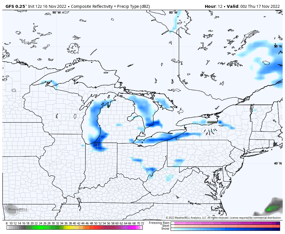
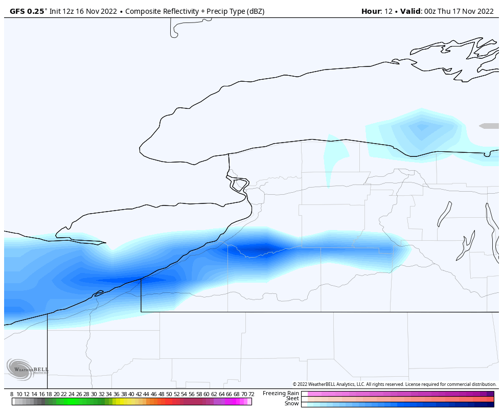
I was going to post some model plots, but they don’t handle these events well. So here is what NWS Buffalo has…. Comparable to that 2014 event.
The metro Buffalo now shows a range with the high end at 48 inches of snow!
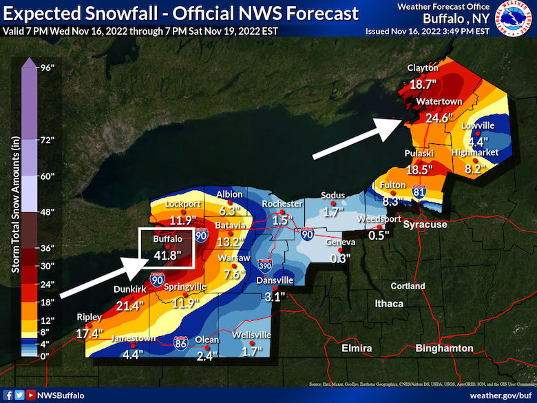
I originally made this featured image, which was 41.8″ for Buffalo ending at the same time period. New data supports a favorable wind for the city and possibly an additional half a foot of snow.


September Starts Meteorological Autumn: Weather Climate Stats For Maryland at Baltimore
If you want a snowy winter, this is what you might want to look for in the rest of the tropical season. (You might be seeing a lot of commercial snow removal people out this Winter).
Rainbow Ice Cave In Mt. Rainier A Very Rare Find: Photos And Video
https://justinweather.com/2022/10/25/winter-weather-outlook-from-the-wooly-bear-caterpillar/
Winter Weather Folklore Top 20 And More Outlook Signals From Nature For Cold And Snow
Click to see more and ‘Book’ a visit to your school
