November 13 2022
Sunday Night Update
The cold air mass that arrived today brought coating of snow to the high mountains of West Virginia, western Maryland, and Pennsylvania. The next event may drop some flakes a little farther east and maybe into nearby suburbs.
Before I explain why I am suggesting this, I need to add a few disclaimers:
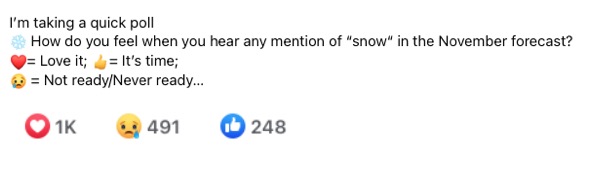
Yes, I love snow and have been leading Faith in the Flakes with my son for over a decade. I am NOT the only one. I posted a ‘Poll’ on Facebook Sunday evening, and got a huge response. Here is the way it looked after just 3 hours. I think there is overwhelming support for the change of season.
No, I do not believe this will be a travel problem locally. Perhaps if you are traveling along or west of I-81, we may have to discuss stickage. I’ll get into that in my next reports.
No, I do not let wishful thinking into my formal forecasting. What I will show you below is the scientific reason I believe there may very well be snow or sleet mixing in for the inland suburbs of Baltimore late Tuesday.
To add to this, we will look at the temperatures at cloud level that may be cold enough , even if surface temps are too warm. So this is for what may fall, NOT what can stick (lay and stay).
Storm Animation:
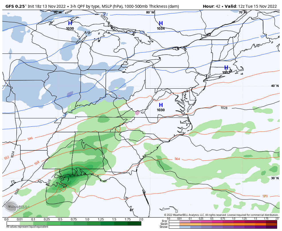
GFS Model 7 AM Tuesday to 7 AM Thursday
This shortwave will bring a band of precipitation to the Northeast, with a cluster of snow (blue) and sleet or slushy mix (pink), then ending as rain. This will be as warmer air follows the initial impact.
Snapshots:
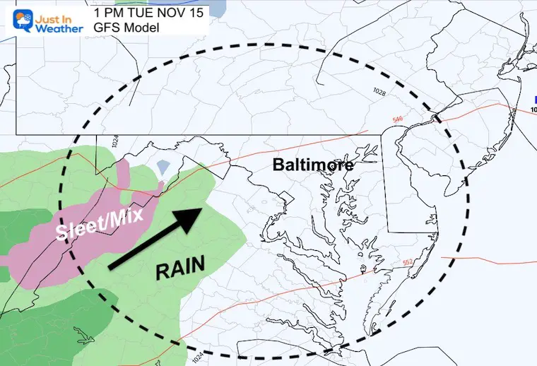
1 PM Tuesday
The initial precipitation will reach the mountains of West Virginia and Virginia as rain or sleet.
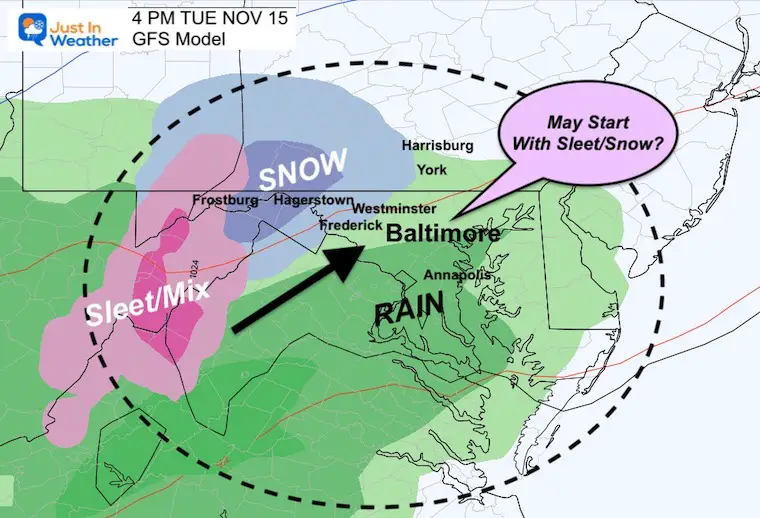
4 PM Tuesday
The ‘stuff’ should begin in central Maryland and southern Pennsylvania during the afternoon. I say stuff since there may be sleet or snow mixing in west and north of Baltimore
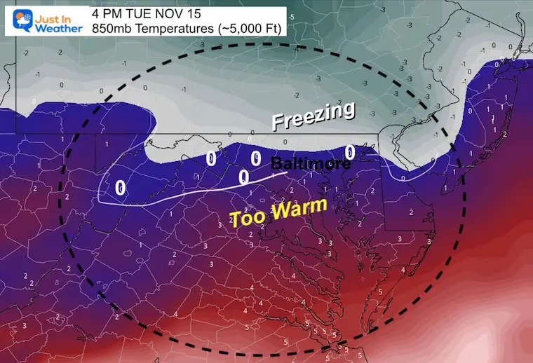
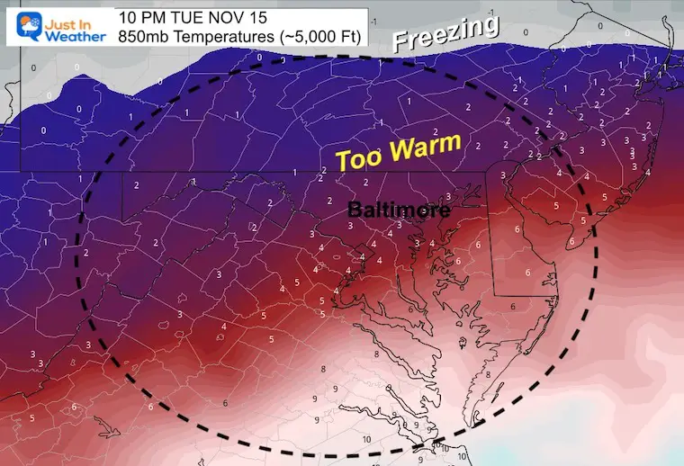
Temperatures at 5,000 Ft
The 850mb level is what we use for cloud level temperatures that can support frozen precipitation. This is measured in Celsius. That 0ºC line in white and gray shading may slice through central Maryland for a few hours.
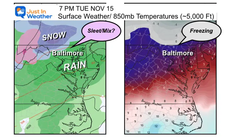
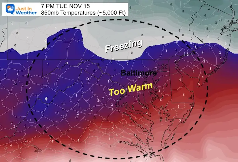
7 PM Tuesday
As the precipitation gets heavier, evaporative cooling and dragging down of colder air can support a wider area of snow and sleet.
In Maryland this may include parts of Frederick, Carroll, and northern Baltimore Counties. In Pennsylvania this may include Adams, York, and Lancaster Counties.
(Ground temps are likely to remain above freezing so no stickage nearby).
Temperatures at 5,000 Ft
The freezing line gets pushed up close to the Maryland/Pennsylvania border.
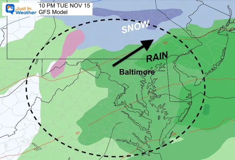
10 PM Tuesday
Temperatures at 5,000 Ft
That freezing line moves farther north, so any mixing will turn to a chilly rain.
Other Models
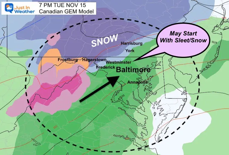
Canadian GEM Model
This model is pretty aggressive along with the GFS to bring in that wintry mix for the northern suburbs of Baltimore.

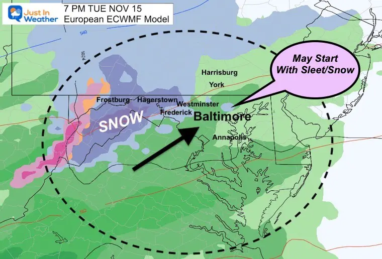
European ECMWF Model
This is now suggesting a hint of pockets with snow or mix in the same inland zones.
Looking Ahead:
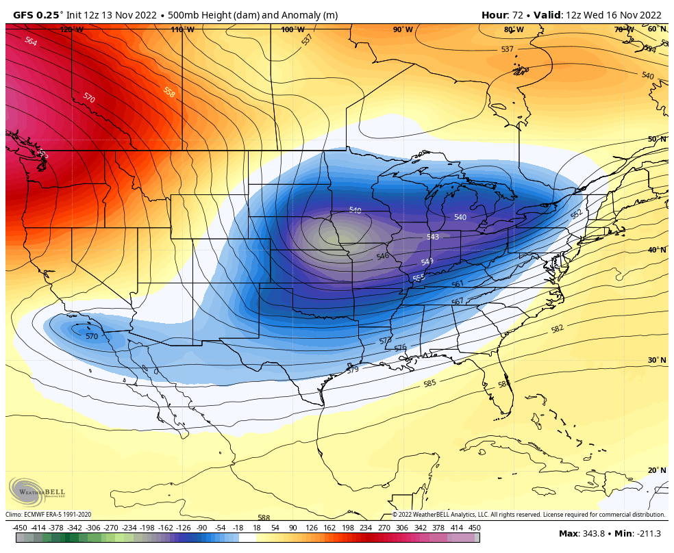
Jet Stream Wednesday Morning to Saturday Morning
A digging trough will establish for the eastern US, so high temps will remain about 10 to 15 degrees cooler than normal.
I will follow this with more detail in my Monday afternoon report.
NEW: November Outlook Map From NOAA Showed This For The First Time
The Big Cool Down Into Mid November: NOAA Outlook Does This For First Time
STEM Assemblies/In School Fields Trips Are Back
Click to see more and ‘Book’ a visit to your school

Also See: Winter Outlook Series:
Winter Outlook 2023 From NOAA Very Different Than Farmers Almanacs
ALSO, SEE THESE OTHER WINTER OUTLOOK REPORTS
Farmer’s Almanac Comparison
Winter Outlook 2023 Early Look At Snow From Two Farmers Almanacs
Triple Dip La Niña Winter
Winter Outlook 2023 La Niña Triple Dip Expectations
CONNECTION TO WINTER?
If you want a snowy winter, this is what you might want to look for in the rest of the tropical season. (You might be seeing a lot of commercial snow removal people out this Winter).
Record August For No Named Tropical Storms: Closer Look At Snow Following
Wooly Bear Caterpillars
Winter Weather Outlook From The Wooly Bear Caterpillar
Persimmon Seeds
Winter Weather Outlook: Persimmon Seeds And Snow Folklore
Click to see Top 20 and MORE
Winter Weather Folklore Top 20 And More Outlook Signals From Nature For Cold And Snow
Normals And Records: Maryland and Baltimore Climate History

Faith in the Flakes Gear

SNOWSTIX – Available Now

Please share your thoughts, best weather pics/videos, or just keep in touch via social media


