


April 24 Weather: Some Showers Then Another Push Of Cold Air Followed By Summer Heat Sunday
Wednesday, April 24 Morning Report A milder start today with most areas in the 50s to near 60ºF along parts of the Bay. There is a push of colder air…
November 6 2022
Now that we are out of Daylight Saving Time, the early darkness gets us thinking about the winter chill on the way. It is not here yet! This past weekend featured 80ºF Saturday and 78ºF Sunday in Baltimore. Both just short of records.
Colder air is on the way for sure. In fact, while I have been looking at the major shift in the jet stream to cool us down, the NOAA Temperature Outlook has plotted something we have not seen before. It has caught the attention of many meteorologists. The next week plus ahead brings both a possible tropical storm AND The Polar Vortex into legitimate discussion.
Let’s start with the first of the two outlooks that are issued.
We can see the Deep Blue showing Very Cold in the central US. This advances to the East, but in this time frame some of the leftover warmth is expected to linger in eastern New England AND Southern Florida.
Wait for it…
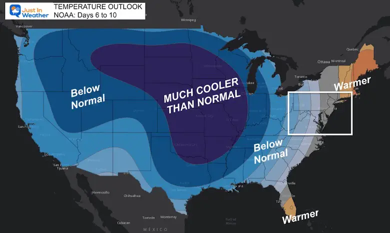
The warm ‘ridge’ will be replaced by a cooler trough later this week. It will help pull that expected tropical system from Florida up the East Coast, which in turn will enhance a second surge of a digging trough behind it into next week.
These temperature outlooks have been issued since 2015, and what we see over the next two weeks across the ‘mainland’ or ‘lower 48 states’ of the US is almost entirely BELOW NORMAL!
If we focus on NEXT WEEK itself, then only Southern Florida has escaped this next round of chilly air. This is nearly all of the continuous United States expecting below normal temperatures. This is the LARGEST COVERAGE AREA for below normal temperatures issued for the 8 to 14 day period.

This has caught the attention of Brian Brettschneider, who has a PhD in Climatology. He said the previous spread of ‘Below Normal’ was 95.7% in February of 2019.
Looking at all 8-14 Day Outlooks issued since 2015, this map has the highest percent of the Lower 48 in Below Normal (over 2,000 forecasts). Previous high was 95.7% on 2/19/2019. Note: station probabilities used to compute percentages are only issued M-F. pic.twitter.com/lAnxvDToj3
— Brian Brettschneider (@Climatologist49) November 5, 2022
Monday Afternoon to Sunday Morning
I know this is too fast to read, but it looks impressive and helps show the story.
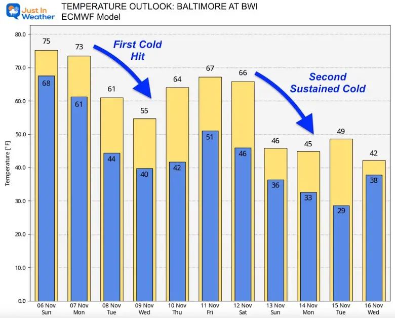
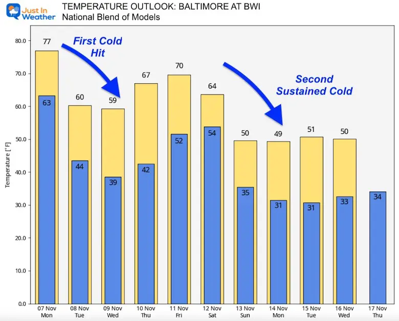
Using home base in Baltimore as reference here, this is what we see comparing models.
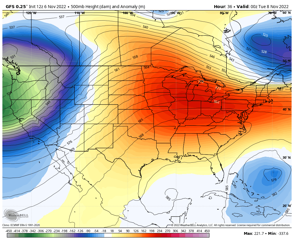
This is the longest outlook projection we have to share. It does show two impulses of colder air. The first one is moderated with a potential tropical system arriving this weekend. Then it will be followed by a second stronger and longer sustained cold pattern.
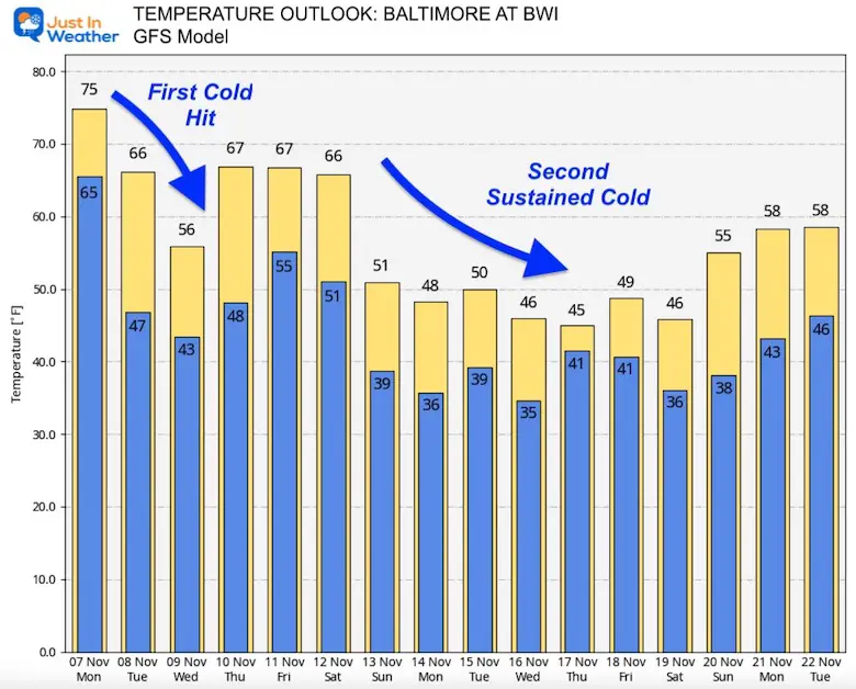
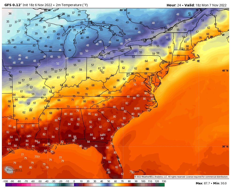
This model also shows the second push of cold air AFTER the weekend tropical cyclone. That cold air in the 40s does seem a bit extreme, yet it is close to 10 degrees below average.
It is that time of year and the well known Dr. Judah Cohen has come back from hiatus with his first acknowledgment that The Polar Vortex is back in play!
I’m baaaack! And who is here to greet meet upon my return this week but my new best friend the stretched #PolarVortex with all the trimmings. It’s good to be back and kicking it off with a new blog tomorrow. Did my absence make anyone’s heart grow fonder? pic.twitter.com/KFHQVbt1fp
— Judah Cohen (@judah47) November 6, 2022
The National Hurricane Center has upgraded this area near The Bahamas to a 90% likelihood to get named in the next 5 days. This would turn curve into Florida… But the models show that by Thursday, so this is really a 4 day outlook.
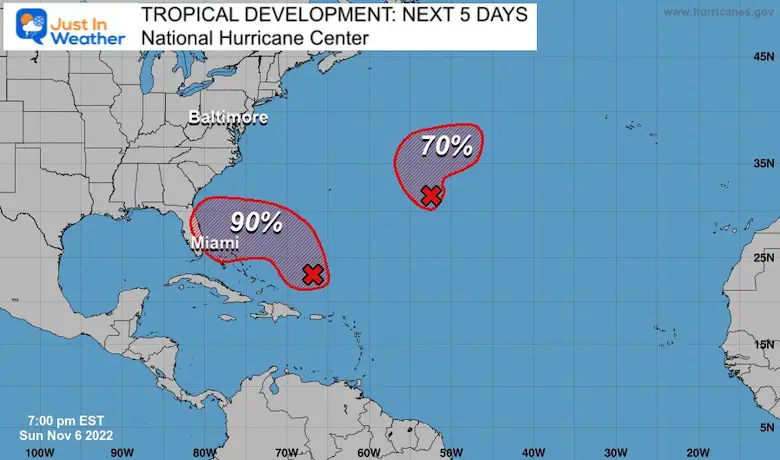
Tracking that storm into South Florida on Thursday, then up the east coast into the weekend.
Rain for the Mid Atlantic should be late Friday to Saturday morning.
Still plenty to sort out and lots of time this week ahead. I will have an update on this in my morning weather report.
Meteor Sighting Friday Night November 4: Video From Baltimore County And Map Where It Tracked
Click to see more and ‘Book’ a visit to your school

Winter Outlook 2023 From NOAA Very Different Than Farmers Almanacs
Winter Outlook 2023 Early Look At Snow From Two Farmers Almanacs
If you want a snowy winter, this is what you might want to look for in the rest of the tropical season. (You might be seeing a lot of commercial snow removal people out this Winter).
Record August For No Named Tropical Storms: Closer Look At Snow Following
Winter Weather Folklore Top 20 And More Outlook Signals From Nature For Cold And Snow


