November 11 2022
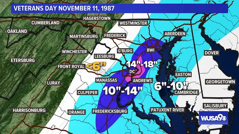
It might be hard to process the thought of snow while the remains of former Hurricane Nicole dump a warm rain on the eastern US today. However, this is also the anniversary of the famous Veterans Day Snowstorm in 1987. That event brought a record 6 inches of snow to Baltimore and 11.5 inches in Washington, DC.
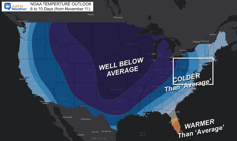
This is NOT what I am suggesting now. However, it is the season where conditions can line up for a burst of winter weather. Much colder air will arrive behind Nicole, and an active jet stream will develop a storm next week. The track of that event is still subject to some adjustment, which means now is the time to start tracking.
NOAA Temperature Outlook
This cold air might be a shock to your system, but it has been expected for the past week.
Let’s back up and track the current event and Nicole, then what will follow.
Surface Weather Map
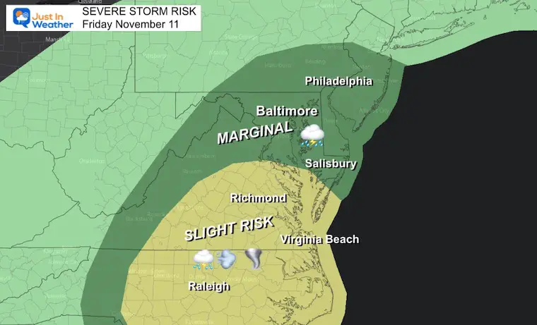
Nicole is no longer a tropical system and The National Hurricane Center has handed off the coverage to another NOAA office. Winds are still 30 to 35 mph, and there is still a severe storm risk. In fact a Tornado Watch has been issued in parts of Virginia and North Carolina.

Severe Storm Risk
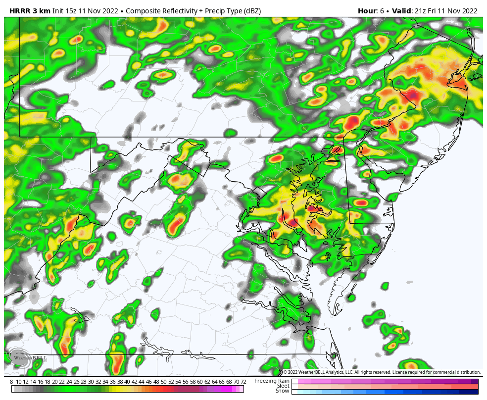
Forecast Animation
4 PM Fri to 4 AM SAT
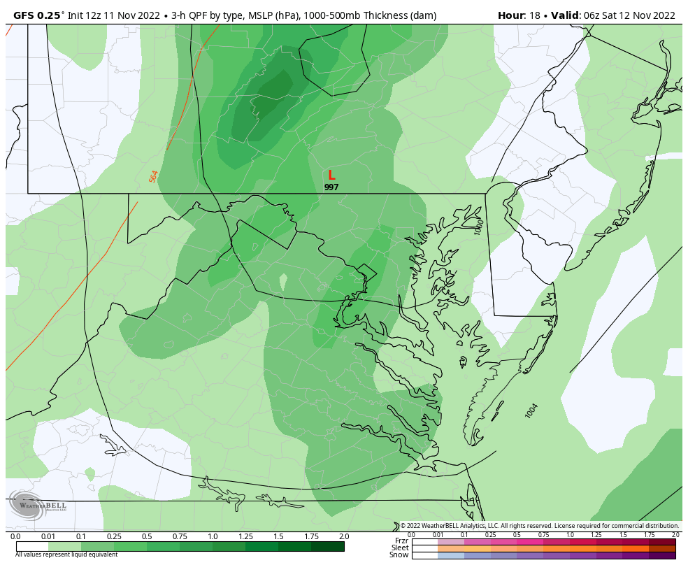
Heavy rain and severe storm risk today through tonight. The Low will race to our north and be out of here by morning.
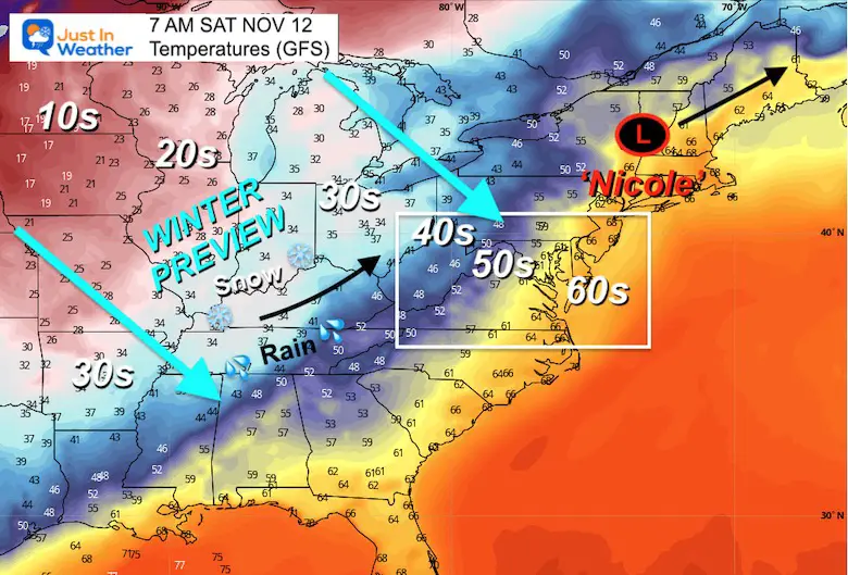
Saturday Morning Snapshot
Low Pressure entering Vermont at sunrise. While still mild in Maryland, the first sign of colder air will be crossing the mountains.
Weekend Storm Animation
Snow showers will fall across the mountains, including around Deep Creek Lake in Garrett County, MD.
1 AM SAT to 1 PM Sun
Another band of rain showers is expected Saturday night, which will usher in the colder air. This will be followed by the snow for the mountains.
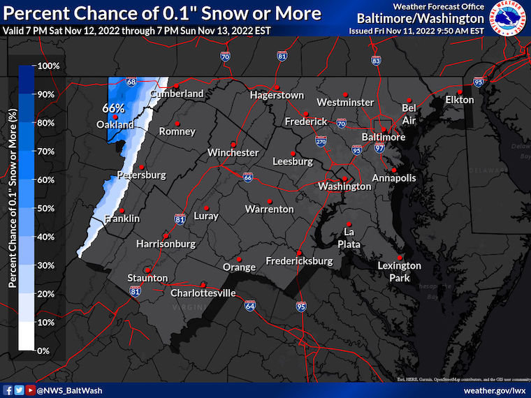
Snow Forecast From The National Weather Service:
A dusting or more is likely around mountain resorts like Wisp, Canaan Valley, and Snowshoe, WV.
Next Up: Tuesday-Wednesday
If you live west and north of the big cities, you might have seen a snowflake show up on your weather apps. If so, here is why…
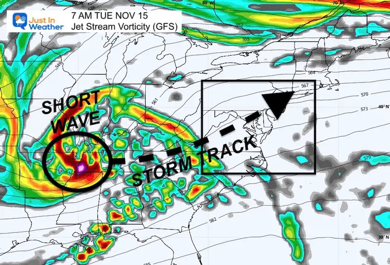
Jet Stream
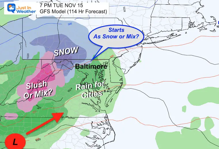
Here is the developing short wave/storm as projected next Tuesday morning on the GFS Model. This looks like a winter event with a track possibly over central Maryland. That track ‘possibility’ is key to note as there will be some adjustment and the cold air will be to the north and west of the path. That is where the ‘snow zone’ is possible.
Storm Simulations
When I first mentioned this, the issue was the timing for ‘something’ next week and the models were not in agreement. They have narrowed the gap overnight to focus on Tuesday into Wednesday.
7 AM Tuesday to 7 PM Wednesday
This is the GFS Model plot.. I will compare to the European Model below.
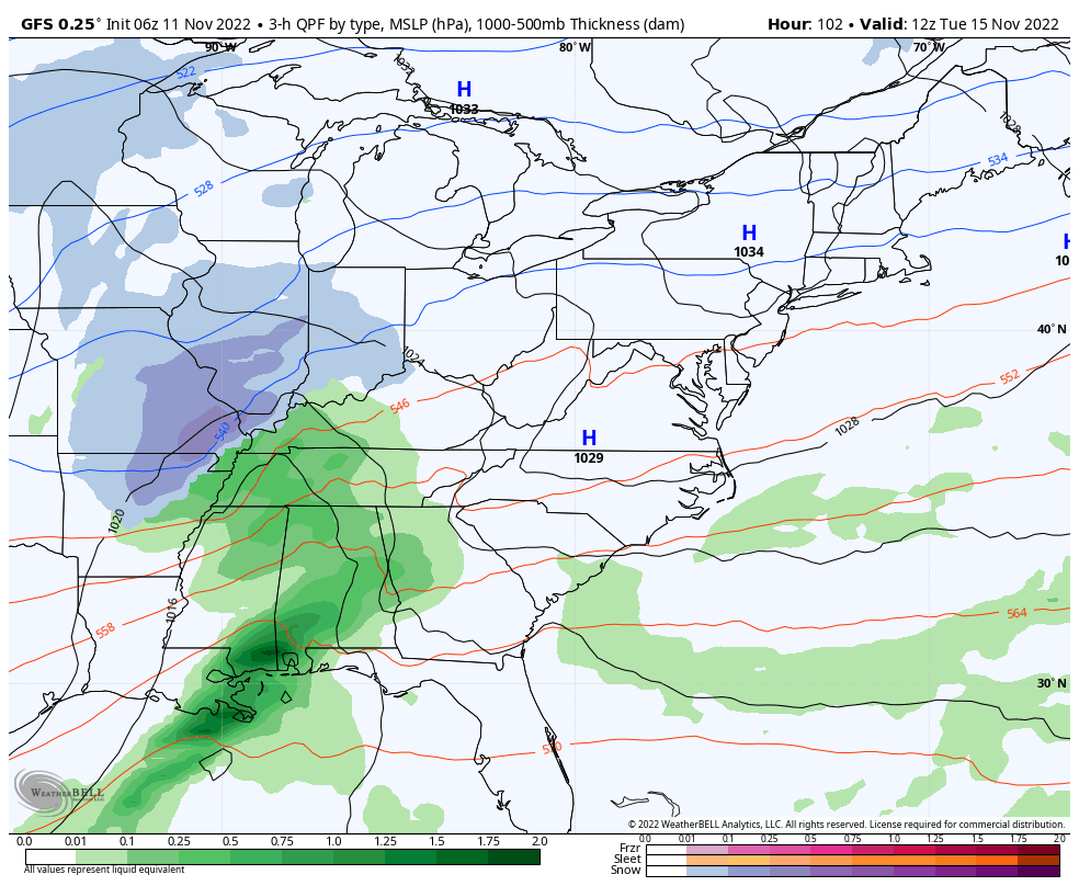
Snow Snapshot Tuesday Evening
This is just enough to be a tease. Yes, we see a shade of blue suggesting some snow potential in Northern Baltimore, Carroll, and Frederick Counties in Maryland. Reminder: This is a ‘suggestion’, but also why I want to document this and focus on trends going forward.
There may be enough snow in the mountains for stickage and even a measurable event. FITF
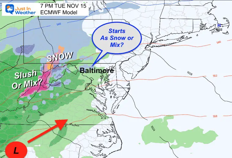
European Model Snapshots
I wanted to highlight key time frames here. Note, this is a little later than the GFS plots, but close in the results (for now).
Track the Low Pressure near or south of I-95.
Tuesday Evening
Also showing a ‘hint’ of snowflakes or a mix for interior Maryland, with more pronounced snow, slush, or icy mix in the mountains.
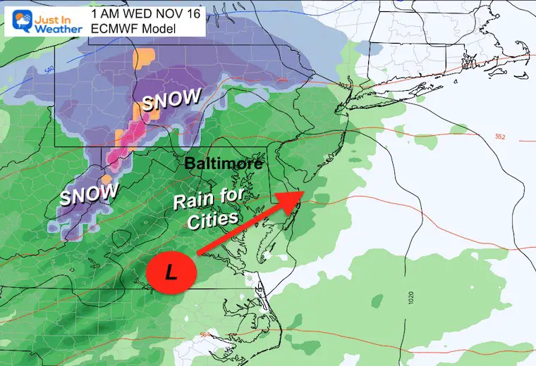
Overnight
Warmer air wins for metro areas. This is simply a chilly rain event for the cities. Meanwhile, the mountains may continue to get snow in places like Wisp and Snowshoe. In the best case scenario, snow may also linger for Ski Liberty and Whitetail in southern Pennsylvania.
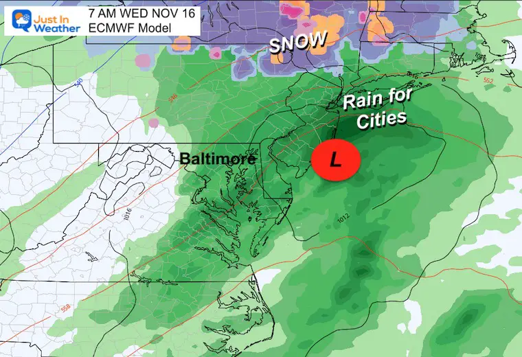
Wednesday Morning
Ending as rain for us.. But that Low Pressure track is very intriguing. If this holds, I find this very positive for snow lovers this winter. I will have more on my thoughts with the winter storm track soon.
Follow Up: Veterans Day Storm 1987
A great summary of that historic weather event as coved by WUSA-9 in Washington, DC. Click in the image for their report.
7 Day Forecast
Colder air will follow Nicole and next week may look like early winter. These are temps for Baltimore. It will be colder inland!
The pattern is trying to develop a storm with inland snow next week. This is still a challenge to determine which day this may develop… stay tuned.

NEW: November Outlook Map From NOAA Showed This For The First Time
The Big Cool Down Into Mid November: NOAA Outlook Does This For First Time
STEM Assemblies/In School Fields Trips Are Back
Click to see more and ‘Book’ a visit to your school

Also See: Winter Outlook Series:
Winter Outlook 2023 From NOAA Very Different Than Farmers Almanacs
ALSO, SEE THESE OTHER WINTER OUTLOOK REPORTS
Farmer’s Almanac Comparison
Winter Outlook 2023 Early Look At Snow From Two Farmers Almanacs
Triple Dip La Niña Winter
Winter Outlook 2023 La Niña Triple Dip Expectations
CONNECTION TO WINTER?
If you want a snowy winter, this is what you might want to look for in the rest of the tropical season. (You might be seeing a lot of commercial snow removal people out this Winter).
Record August For No Named Tropical Storms: Closer Look At Snow Following
Wooly Bear Caterpillars
Winter Weather Outlook From The Wooly Bear Caterpillar
Persimmon Seeds
Winter Weather Outlook: Persimmon Seeds And Snow Folklore
Click to see Top 20 and MORE
Winter Weather Folklore Top 20 And More Outlook Signals From Nature For Cold And Snow
Normals And Records: Maryland and Baltimore Climate History

Faith in the Flakes Gear

SNOWSTIX – Available Now

Please share your thoughts, best weather pics/videos, or just keep in touch via social media


