Thursday November 10
Evening Update
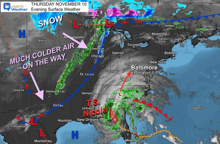
Tropical Storm Nicole has done its damage in Florida, made its turn north, and is about to be downgraded to a Tropical Depression. The impact on our region in the Mid Atlantic will be heavy rain, even a potential for some severe cells and isolated tornadoes. But what will follow is a pattern change that will undoubtedly be a winter preview. In fact another system next week could bring snow to the nearby mountains and an extended chill for all of us.
In this post I will cover the rain timeline, then the pattern change. I am including the Live Radar Widget to track the rain arriving Friday morning if you happen to read this then.
While I already mentioned snow, I need to also state that the energy that may produce it is uncertain and the two main models are split on how and when to produce it. Let’s take a look.
Thursday Evening Set Up
Tropical Storm Nicole had peak winds of 40 mph, extending 175 miles from the center. It’s a large system.
The cold front from Chicago to Dallas is what will help steer Nicole and then usher in that Winter Preview to follow.
Evening IR Satellite Loop
You may have noticed the clouds arrive before sunset. That was ahead of Nicole. Here we can see multiple bands pinwheel up to the north.
Compare the Live Radar to the forecast maps below.
Live Radar Widget
Rain Simulation:
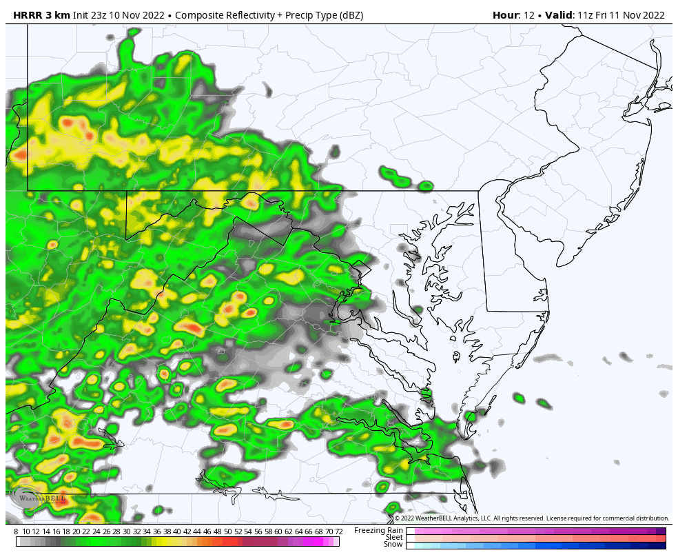
6 AM to 12 PM – HRRR Model
The rain will move in by sunrise for most, then we get our first break by noon.
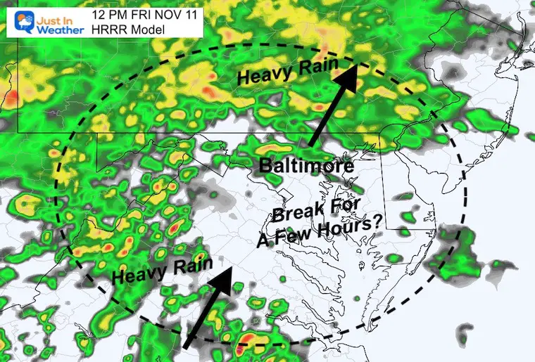
Noon Snapshot
This is not perfect, but does suggest a broad break in metro areas, while steady rain pushed north. The next round will arrive from the south
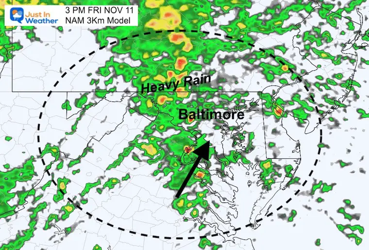
3 PM Snapshot
The next wave should be passing through central Maryland and metro areas.
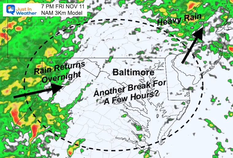
7 PM Snapshot
Our next break may occur just in time for your evening plans. I can’t rule out all rain, but at least tapering to scattered showers. Temps will remain mild at this time…
In the mountains the rain will be more persistent, and send the final surge overnight.
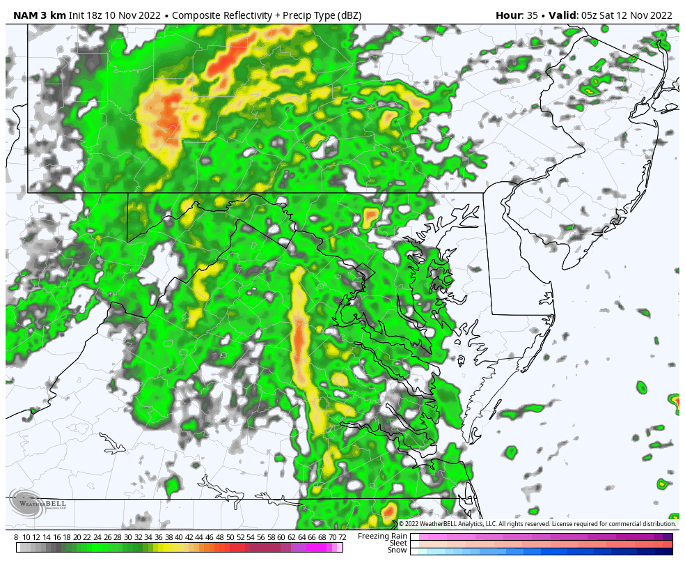
Radar Simulation
Midnight to 7 AM Saturday
Heavy rain, and a risk for severe cells between midnight and 4 AM. The storm will pull out of here faster… It may be completely gone by 6 AM.
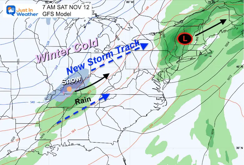
Saturday Morning at 7 AM
The center of Nicole should be located in New England.
The jet stream will bring a disturbance behind it with a cluster of snow and rain developing over Kentucky and Tennessee. This first round is likely to pass to our west, but setting the stage for the week ahead.
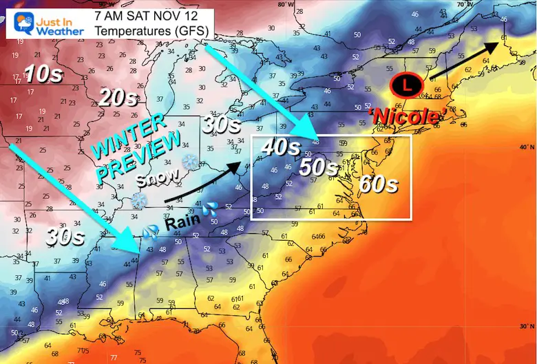
Temperatures at 7 AM
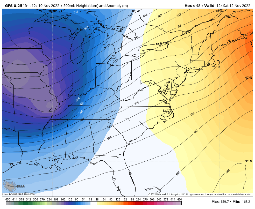
While still mild locally in the wake of Nicole, the cold air mass is on the move to dominate the nation. This is what will move in for the days that follow.
Jet Stream Animation
7 AM Sat Nov 12 to 7 PM Fri Nov 18
Watch the evolution of a diving trough of cold air. This winter like pattern will bring another storm with it.
Two Versions Of The Next Storm
With the active jet stream and contrast of very cold air, Low Pressure will send rain and snow up the Ohio Valley and Appalachians. The GFS and European ECMWF both show it, just not at the same time.
I am cautiously showing you the potential for a storm next week. I know other weather outlets may try to hype a snow event. I WILL NOT DO THAT. I usually would not take any snow potential seriously until within the 7 day time frame.
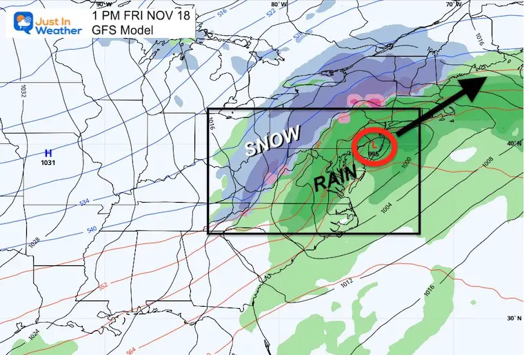
GFS Model
7 PM THU to 7 PM Fri
This holds off that storm potential until later in the week.
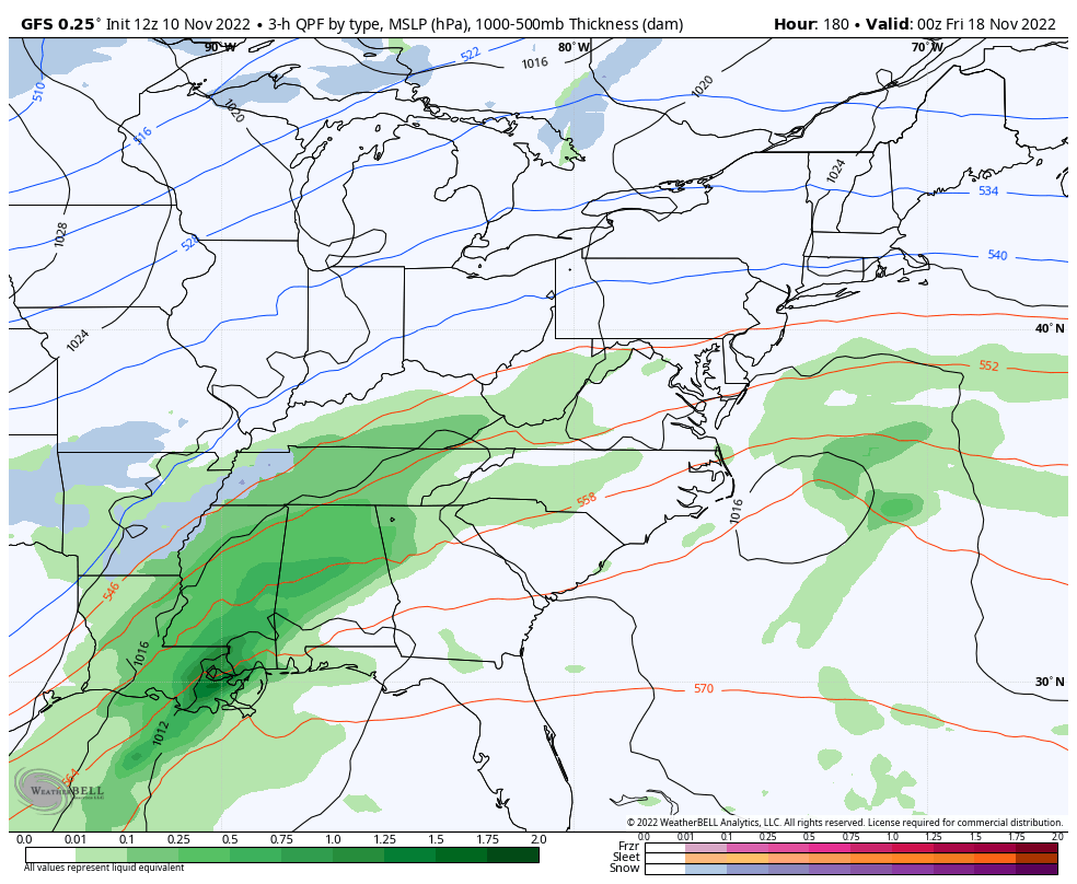
Snapshot Friday Morning
Organized Low Pressure bringing classic heavy and chilly rain to the big cities, while snow in the mountains. This looks like a solid winter storm event… but not set in stone. Any shift in track can make a big difference… So we have lots to work on over the next week.
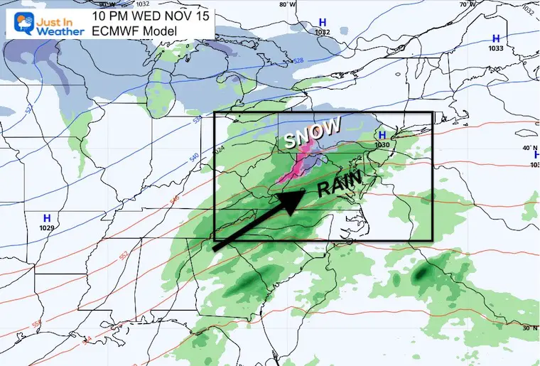
European ECMWF Model
7 AM Tue Nov 15 to 7 PM Wed Nov 16
This is less organized and about 24 to 36 hours earlier.
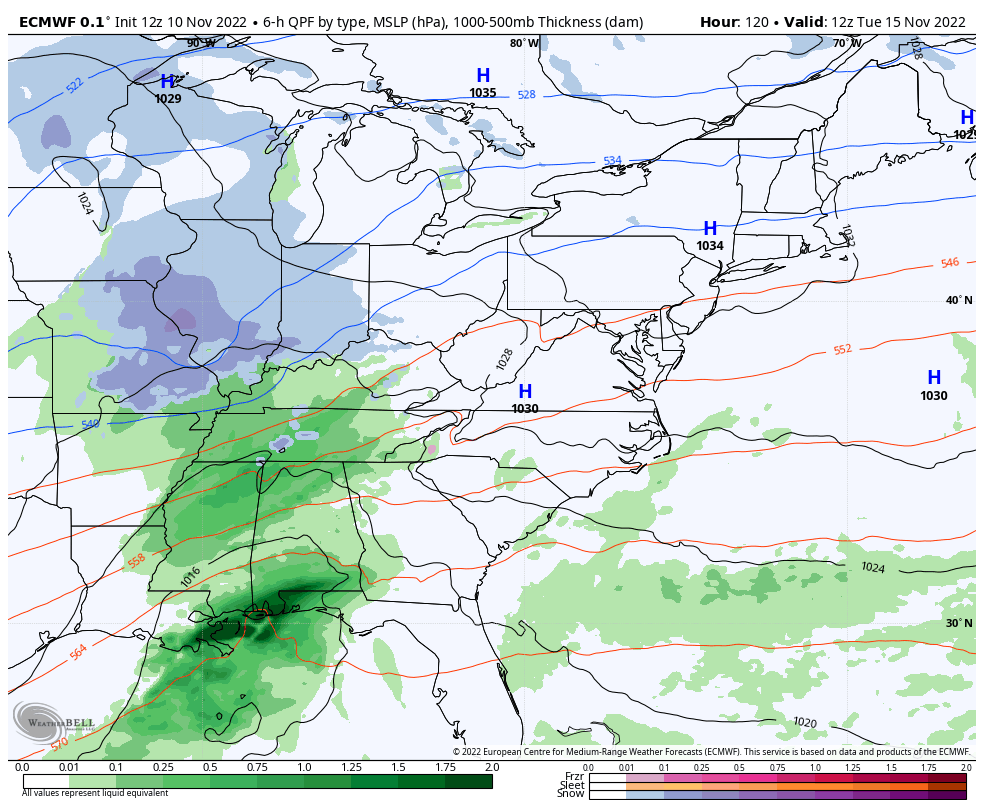
Snapshot Wednesday Night
Less organized with no central Low Pressure showing at this time, but still a broad area of rain and mountain snow. This does include western Maryland.
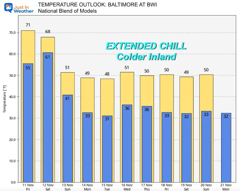
Temperature Outlook
National Blend of Models
The one near certainty is that temps will tank and remain cold next week. This is that outlook we discussed last weekend.
Please note this product is for BWI. It is usually colder, in this case 40s, farther inland.
NEW: November Outlook Map From NOAA Showed This For The First Time
The Big Cool Down Into Mid November: NOAA Outlook Does This For First Time
Also See: Winter Outlook Series:
Winter Outlook 2023 From NOAA Very Different Than Farmers Almanacs
ALSO, SEE THESE OTHER WINTER OUTLOOK REPORTS
Farmer’s Almanac Comparison
Winter Outlook 2023 Early Look At Snow From Two Farmers Almanacs
Triple Dip La Niña Winter
Winter Outlook 2023 La Niña Triple Dip Expectations
CONNECTION TO WINTER?
If you want a snowy winter, this is what you might want to look for in the rest of the tropical season. (You might be seeing a lot of commercial snow removal people out this Winter).
Record August For No Named Tropical Storms: Closer Look At Snow Following
Wooly Bear Caterpillars
Winter Weather Outlook From The Wooly Bear Caterpillar
Persimmon Seeds
Winter Weather Outlook: Persimmon Seeds And Snow Folklore
Click to see Top 20 and MORE
Winter Weather Folklore Top 20 And More Outlook Signals From Nature For Cold And Snow
Normals And Records: Maryland and Baltimore Climate History

Faith in the Flakes Gear

SNOWSTIX – Available Now

Please share your thoughts, best weather pics/videos, or just keep in touch via social media


