


May 6 Morning Fog Then Rain Returns Tonight
Monday May 6 Morning Report The pattern remains soggy with dense fog this morning. The next round of rain will return tonight into Tuesday morning. Then it should break up…
November 9 2022
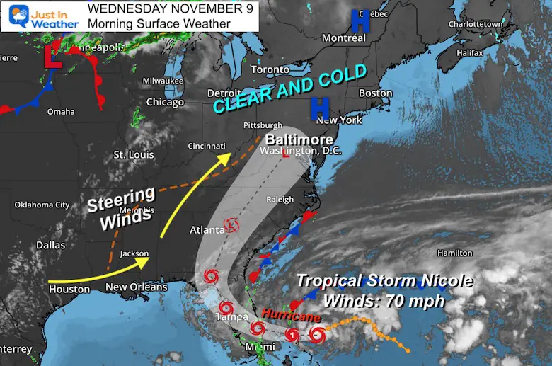
Wednesday Morning Update
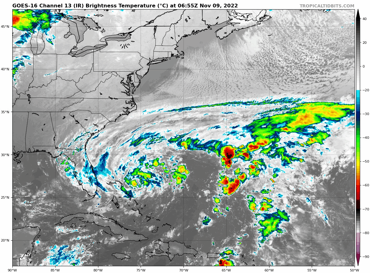
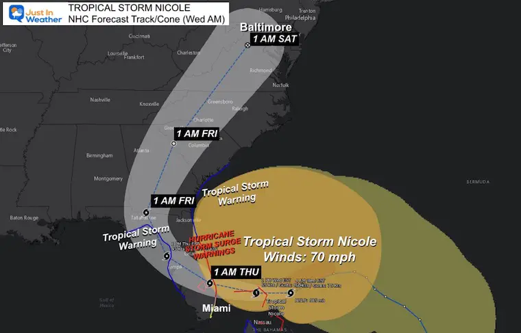
Tropical Storm Nicole continues to get stronger as it travels westward. This morning winds were 70 mph and it is expected to become a Category 1 Hurricane as it crosses the Northern Bahamas. Landfall on Florida will be after midnight, then we will track it crossing the state and heading (our way) north.
The focus of this post will be on the expected hurricane landfall and then the impact for the Mid Atlantic.
Tropical Storm Nicole has 70 mph winds and is heading west towards Florida. High Pressure controls the Mid Atlantic (for now) and the next storm in the Northern Plains is the pattern change that has steering winds ahead of it. This is what will guide Nicole to turn north.
The National Hurricane Center expects a transition to full Tropical Storm today.
LOCATION…26.6N 75.7W
See the warnings below
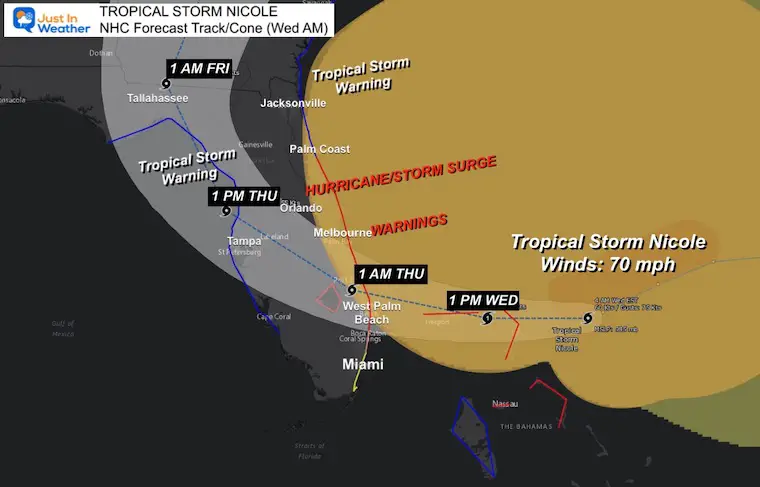
A Hurricane Warning is in effect for…
A Tropical Storm Warning is in effect for…
A Hurricane Watch is in effect for…
A Tropical Storm Watch is in effect for…
Storm Surge
A Storm Surge Warning is in effect for…
A Storm Surge Watch is in effect for…
I believe the European Model has the best handle on this. Local look below…
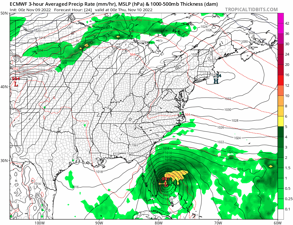
Nicole will weaken to a Tropical Depression inland, with the Core Low tracking close to Baltimore. Closer look at the Mid Atlantic rainfall below.
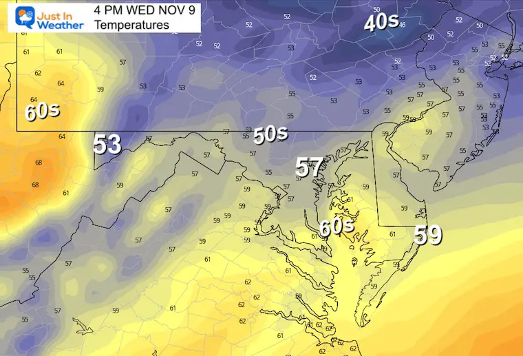
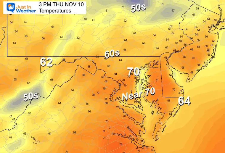
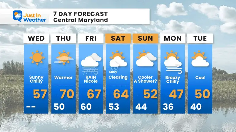
It will be much cooler than yesterday
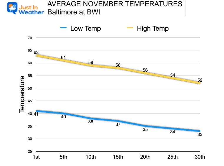
Normal Low in Baltimore: 39ºF
Record 24ºF in 2019
SNOW: Trace in 2007
Normal High in Baltimore: 60ºF
Record 78ºF 1994
Warmer, but high clouds will begin to take over the sky ahead of Nicole.
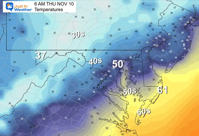
This will be a quick mover. The heavy rain will fall on Friday, with perhaps a lull in the evening, then a final surge with the Core Low early Saturday.
The rest of Saturday will clear out and remain mild.
This has lowered a little simply due to faster speed of the storm… getting out sooner.
We can still look for between 1 to 2 inches from central Maryland westward. Higher in some spots.
Less rain around the Bay, across Delmarva, to the beaches.
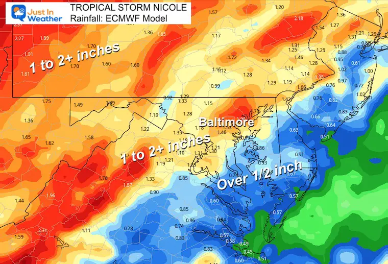
Heavy rain Friday to early Saturday, then much colder air will follow.
This pattern may bring snow to western Maryland by Sunday and Monday.
The Big Cool Down Into Mid November: NOAA Outlook Does This For First Time
Winter Outlook 2023 From NOAA Very Different Than Farmers Almanacs
Winter Outlook 2023 Early Look At Snow From Two Farmers Almanacs
If you want a snowy winter, this is what you might want to look for in the rest of the tropical season. (You might be seeing a lot of commercial snow removal people out this Winter).
Record August For No Named Tropical Storms: Closer Look At Snow Following
Winter Weather Folklore Top 20 And More Outlook Signals From Nature For Cold And Snow


