TS Ian Back Over Water And Hurricane Warning Issued For All Of Coastal South Carolina
Thursday Morning September 29, 2022
At 11 AM the center of Tropical Storm Ian was back over the water, the fuel source. The surface temperatures do support potential development back up to Category 1 Hurricane. Winds are already up to 70 mph and a Hurricane Warning has been issued for ALL of the South Carolina Coast. The storm is expected to make a second landfall as a hurricane near Charleston, South Carolina by Thursday evening. See the maps below.
IAN WILL BE A HURRICANE AGAIN TODAY
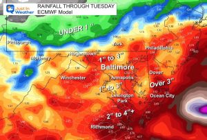
Farther North, flooding rain is possible all the way into Maryland this weekend… and with the lingering upper Low hanging around through early next week.
Wind Profile at 11 AM
Note the EAST Wind is ONSHORE, resulting in Storm Surge for Northeast Florida. The St. Johns River in Jacksonville is particularly vulnerable.
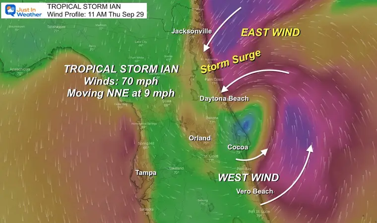
Ian: Sep 29 Thursday Morning
Quick Stats at 11 AM
- Winds are 70 mph
- Moving to the NNE 9 mph
- Located 40 miles SE of Orlando, 25 miles NE of Cape Canaveral, 285 miles South of Charleston SC
- HUGE SIZE
- Tropical Storm force winds extend 415 miles from the center.
Visible Satellite Loop
This spectrum shows the center better as it reaches the water of the Atlantic Ocean by Cocoa Beach.

Power Outages as of 11 AM Thursday, Sep 29
Over 2.6 Million Customers out. While some on the Gulf Coast get back online, more outages are expected on the Atlantic Coast.
It has been widely accepted that parts of the grid will be unrepairable and need to be completely replaced.
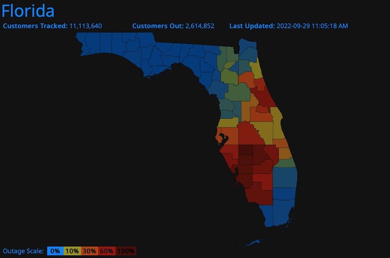
See the live update from https://poweroutage.us/area/state/florida
LIVE RADAR/LIGHTNING WIDGET
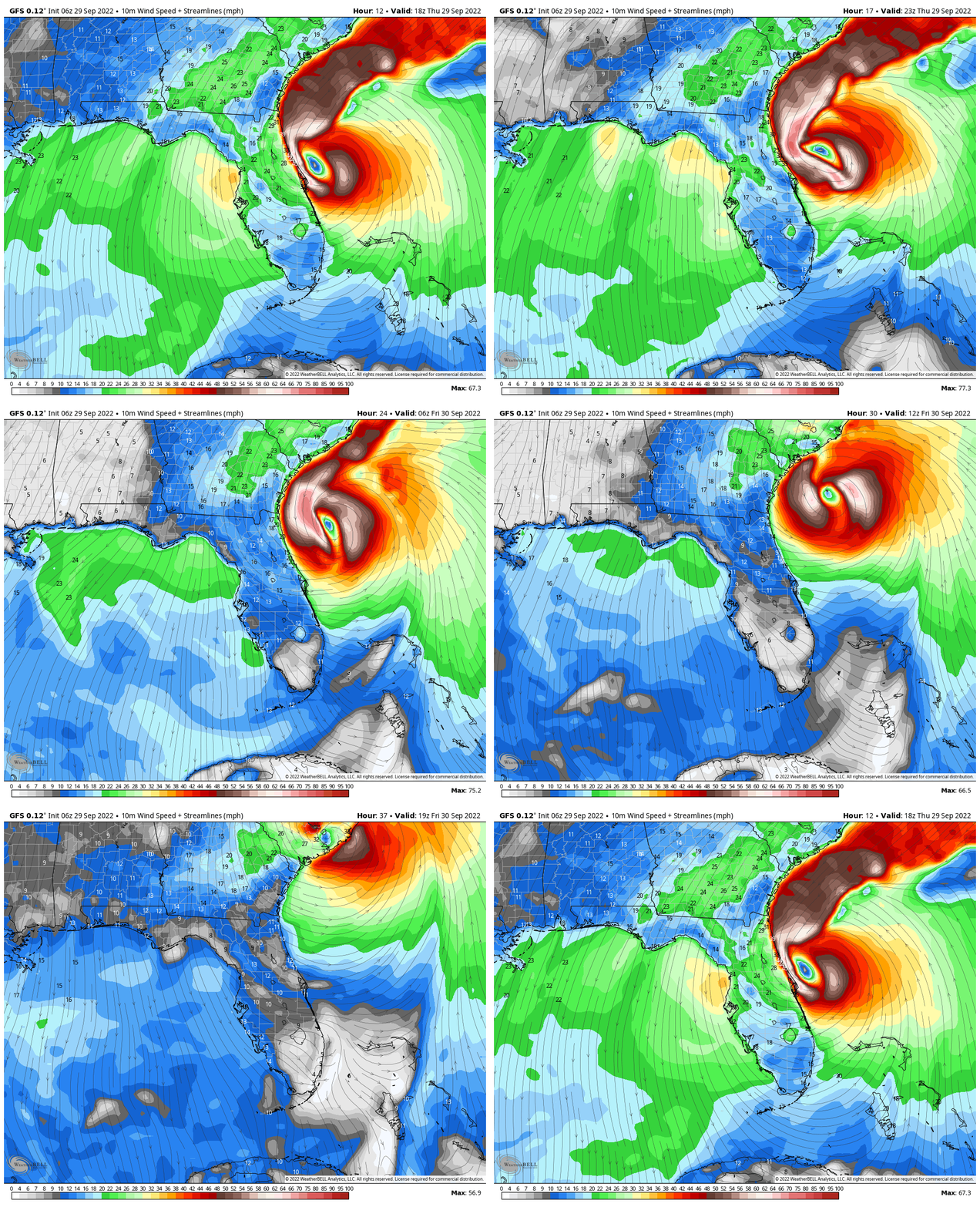
Forecast Winds
2 PM Thursday to 4 PM Friday – GFS Model
NEW Watches and Warnings
A Storm Surge Warning is in effect for…
* Flagler/Volusia Line to Little River Inlet
* Neuse River
* St. Johns River
A Hurricane Warning is in effect for…
* Savannah River to Little River Inlet
A Tropical Storm Warning is in effect for…
* Jupiter Inlet Florida to Duck North Carolina
* Pamlico Sound
A Storm Surge Watch is in effect for…
* North of South Santee River to Duck North Carolina
* Pamlico River
A Hurricane Watch is in effect for…
* Flagler/Volusia County Line to the Savannah River
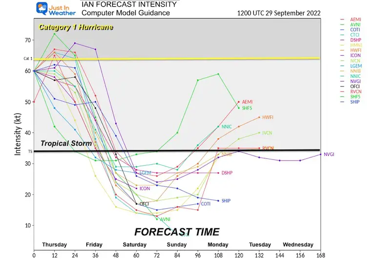
Computer Model Guidance Intensity Forecast
A few members show this back to Category 1 Hurricane later today. Then weakening again after a second US landfall.
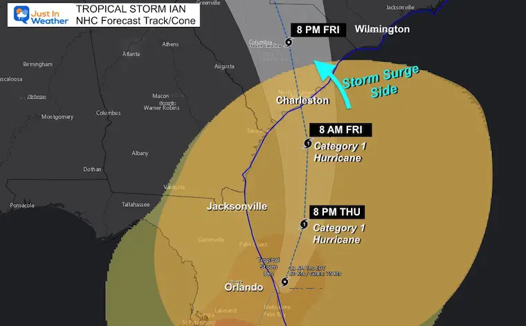
National Hurricane Center Forecast Track
This will become a Category 1 Hurricane again today, then curve into the coast of South Carolina… Bringing additional flooding rain and storm surge to places like the St. Johns River in Jacksonville, then coastal South Carolina.
The landfall Storm Surge will be strongest on the RIGHT SIDE of the Eye, up the coast of South Carolina.
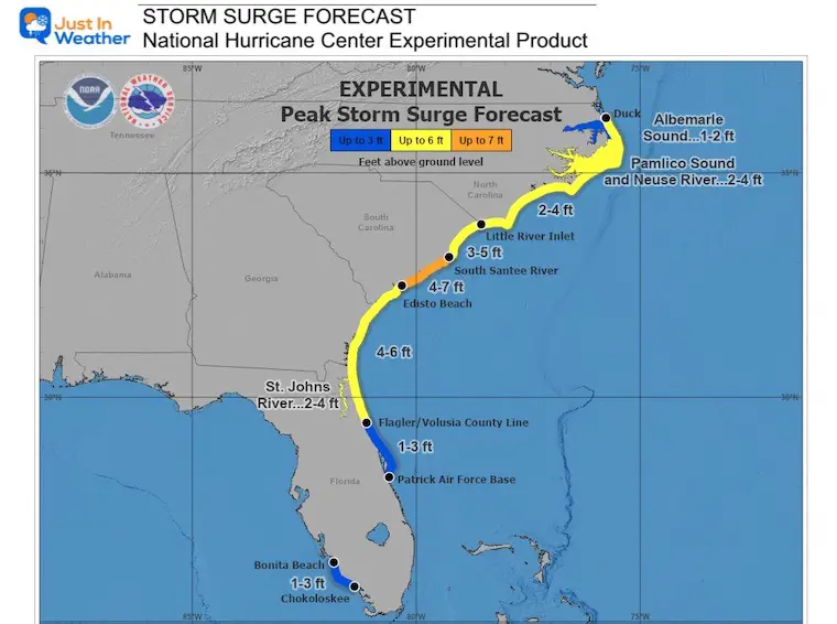
Storm Surge Forecast
A Storm Surge Warning is in effect for…
* Flagler/Volusia Line to Little River Inlet
* Neuse River
St. Johns River
A Storm Surge Watch is in effect for…
* North of South Santee River to Duck North Carolina
* Pamlico River
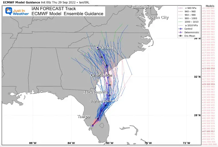
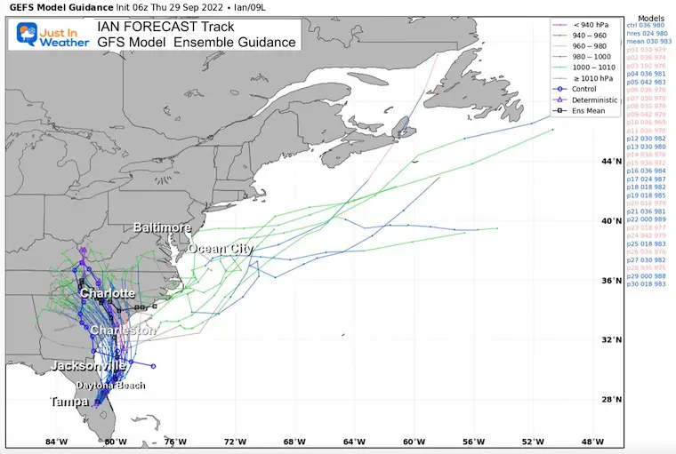
Computer Model Tracks
Note that each model has many different solutions called members. All of these are plotted together for an Ensemble. The final solution is the average of them all.
European ECWMF Model
GFS Model
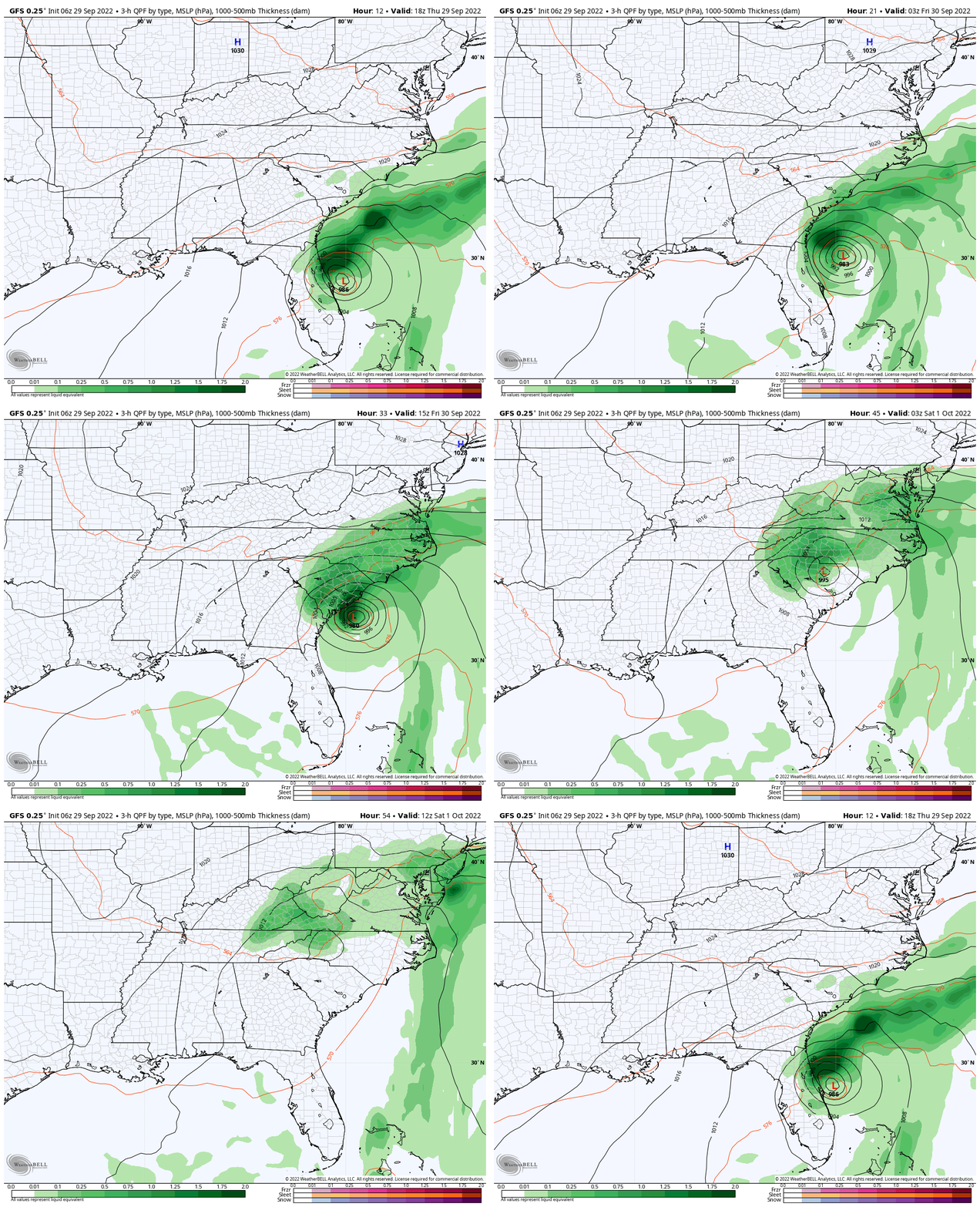
Forecast: Storm Simulation
2 PM Thursday to 8 AM Saturday
Heavy rain spreads inland and reaches Maryland to start the weekend
(I will have a local look at the Mid Atlantic later today)
Explore More
My morning report about the impact on the Mid-Atlantic. I will have a more focused report for The Chesapeake Bay and Delmarva Beaches later today.
Weather posts straight to your inbox
Sign up and be the first to know!
PATTERN CHANGER?
CONNECTION TO WINTER?
If you want a snowy winter, this is what you might want to look for in the rest of the tropical season.
Rainbow Ice Cave In Mt. Rainier A Very Rare Find: Photos And Video
Weather posts straight to your inbox
Sign up and be the first to know!
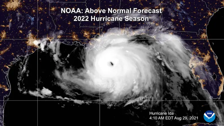
Hurricane Season Forecast: June 1 Through November 30
NOAA 2022 Hurricane Forecast- Above Normal Again
Related Posts
NOAA Study: Reducing Air Pollution INCREASED Tropical Storms
Atlantic Tropical History: Maps of Origin Regions Every 10 Days
Please share your thoughts, best weather pics/videos, or just keep in touch via social media
-
Facebook: Justin Berk, Meteorologist
-
Twitter: @JustinWeather
-
Instagram: justinweather
STEM Assemblies/In School Fields Trips Are Back
Click to see more and ‘Book’ a visit to your school


