Thursday Evening September 29, 2022
At 5 PM Ian is a hurricane again with winds of 75 mph. It is over the very warm water of the Gulf Stream. It is NOT going to be anything like what hit Florida, but it will be a formidable event as an expected Category 1.
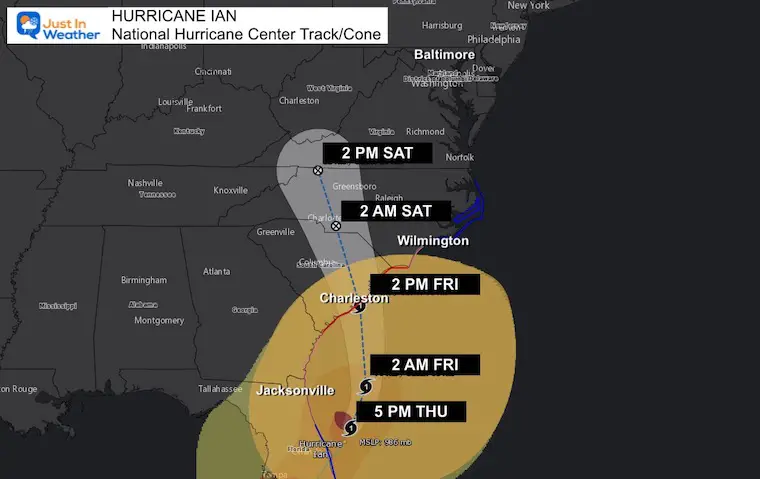
So far Ian has been challenging because it veered to the RIGHT side of the forecast cone with less of a slow down. That allowed it to cross Florida faster, which in turn allowed it more space and tie over into the Atlantic to intensify again.
A Hurricane Warning has been issued for ALL of the South Carolina Coast. I would like to once again examine the strong vs. weak side of the storm. This, plus the shape of the coastline, will help show which areas will get hit hardest, while others will avoid the worst.
Visible Satellite at 5 PM
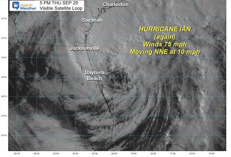
Hurricane Ian: Sep 29 Thursday Evening
Quick Stats at 5 PM
- Winds are 75 mph
- Moving to the NNE 10 mph
- Located 240 miles South of Charleston, SC
- HUGE SIZE
- Hurricane Force Winds extends 45 miles from the center.
- Tropical Storm force winds extend 415 miles from the center.
LIVE RADAR/LIGHTNING WIDGET
Wind And Storm Surge Focus
The most destructive part of a landfalling hurricane is the storm surge. We just saw that in Florida (and I have included two videos on the pop out box here on this page).
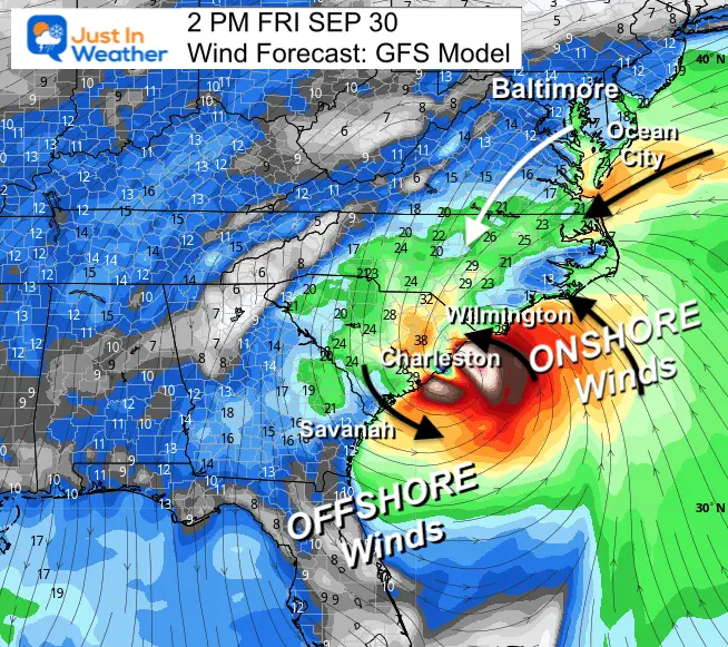
Here is a look at the forecast and IF landfall is around Charleston SC, who may get the strongest, or weaker part of the storm.
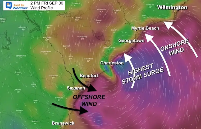
Forecast Winds
8 PM Thursday to 2 PM Friday – GFS Model
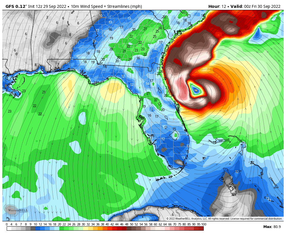
Snapshot at 2 PM Friday
I want to show this wider view to show the immediate impact of the wind and storm surge.
Farther up the coast, there will be brisk winds to Ocean City in Maryland, but more like a Nor’easter there. I will have a focus on the Mid Atlantic shortly.
Let’s take a closer look at South Carolina below.
Reminder About The Storm Structure:
The right side is stronger due to winds moving onshore FROM the ocean or Onshore with the forward movement of the storm.
The left side is weaker with winds FROM the land or Offshore and opposite the forward movement of the storm.
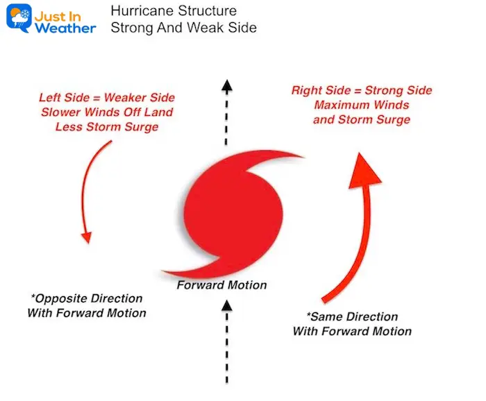
Coastline Winds/Waves:
South Carolina Close Up
Considering the potential landfall on or near Charleston, SC… The stronger impact will be to the north on that RIGHT SIDE with the Onshore Wind! This will include Awendaw and Georgetown.
However to south or LEFT, Hilton Head and Savannah will get much less storm surge with the wind blowing Offshore.

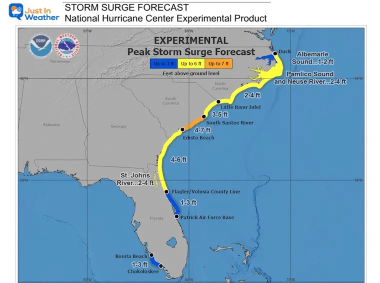
A Storm Surge Warning is in effect for…
* Flagler/Volusia Line to Little River Inlet
* Neuse River
* St. Johns River
A Storm Surge Watch is in effect for…
* North of Cape Fear to Duck North Carolina
* Pamlico River
* Cape Fear River
Wider View: Georgia to North Carolina
Storm Surge Experimental Graphic
EXPLORE MORE:
See how the Carolina Coastline was shaped by thousands of years of storms and how is can catch more or get protected further up the coast.
How Hurricanes Interact With Land And Helped Shape The US East Coast
National Hurricane Center Forecast Track/Cone
NEW Watches and Warnings
A Storm Surge Warning is in effect for…
* Flagler/Volusia Line to Cape Fear
* Neuse River
* St. Johns River
A Hurricane Warning is in effect for…
* Savannah River to Cape Fear
A Tropical Storm Warning is in effect for…
* Vero Beach Florida to Savannah River
* Cape Fear to Duck North Carolina
* Pamlico Sound
A Storm Surge Watch is in effect for…
* North of Cape Fear to Duck North Carolina
* Pamlico River
* Cape Fear River
A Hurricane Watch is in effect for…
* Flagler/Volusia County Line to the Savannah River
* East of Cape Fear to Surf City
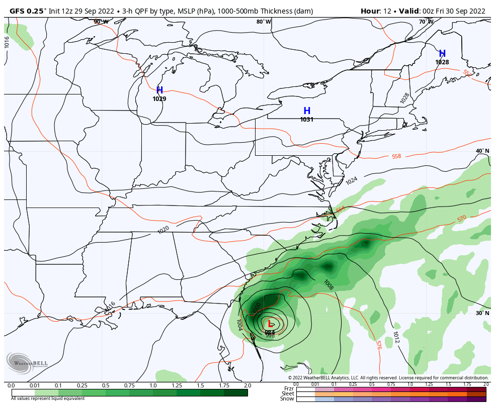
Forecast: Storm Simulation
8 PM Thursday to 8 AM Saturday
Heavy rain spreads inland and reaches Maryland Friday into Saturday morning.
(I will have a more detailed local look at the Mid Atlantic including The Chesapeake Bay and Ocean City in my evening report).
Top 5 Landfalling Storms With Winds 155 mph or Higher Include:
- 185 mph in 1935 – Labor Day Day (unnamed)
- 175 mph in 1969 – Camile
- 165 mph in 1992 – Andrew
- 160 mph in 2018 – Michael
- 155 mph in 2023 – Ian
Storm Name History/Retirement
Since 1954, 94 storms have had their names retired.
I named storms are 13 of them.
Since 2000, 44 storm names were retired.
Of them, 11 began with the letter I. This is going to be number 12.
PATTERN CHANGER?
Hurricane Ian May Help Cooler Pattern Change: Monitor For Atmospheric Memory This Winter
CONNECTION TO WINTER?
If you want a snowy winter, this is what you might want to look for in the rest of the tropical season.
Record August For No Named Tropical Storms: Closer Look At Snow Following
Hurricane Season Forecast: June 1 Through November 30
NOAA 2022 Hurricane Forecast- Above Normal Again

Related Posts
NOAA Study: Reducing Air Pollution INCREASED Tropical Storms

Atlantic Tropical History: Maps of Origin Regions Every 10 Days


Please share your thoughts, best weather pics/videos, or just keep in touch via social media
STEM Assemblies/In School Fields Trips Are Back
Click to see more and ‘Book’ a visit to your school


