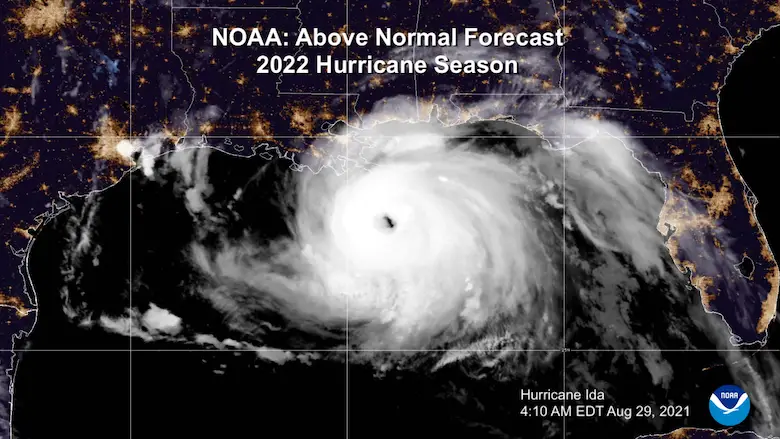
Tropical Storm Ian Still Expected To Be A Major Hurricane As Track Shifts West
Sunday September 25, 2022
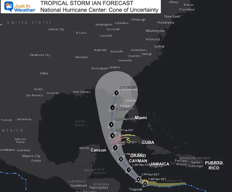
Tropical Storm Ian is slowly organizing in the Caribbean and there is a warning out for The Cayman Islands. The one trend I have suggested is being verified: The track continues to shift a little farther west. That is why there is a cone of uncertainty, however it still includes Cuba and Florida.
Ian is expected to become a Major Hurricane Category 3 or higher before hitting far western Cuba Tuesday, then remain strong while entering the Gulf of Mexico. That western shift now keeps it farther west of Tampa, with landfall closer to Pensacola. Governor Ron DeSantis has placed the entire state of Florida under a State of Emergency and the next Artemis Rocket Launch attempt has been scrubbed by NASA.
Heavy rain is expected to reach the Mid Atlantic next weekend. See the maps below,
Tropical Storm Ian Quick Stats
- Winds are 50 mph
- Moving to the WNW at 12 mph
- Tropical Storm force winds extend 60 miles from the center.
Satellite Loops
(I have to embed from my Twitter feed until I can fix the animations)
Close Up
Sunday Morning September 25#TropicalStormIan satellite (CLOSE)
Winds 45 mph
Moving WNW at 12 mph
*Still organizing pic.twitter.com/ifcXu2ZGcl— Justin Berk (@JustinWeather) September 25, 2022
Wide View
Sunday Morning September 25#TropicalStormIan satellite (WIDE Caribbean/Gulf)
Winds 45 mph
Moving WNW at 12 mph
FORECAST: Category 3 or higher
📍 Landfall: Western Cuba –> Then Florida Panhandle pic.twitter.com/lUELX6TjfI— Justin Berk (@JustinWeather) September 25, 2022
Snapshot
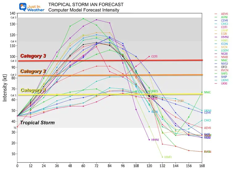
Forecast Computer Model Intensity:
Almost all models show Ian reaching Category 3 or higher by early next week.
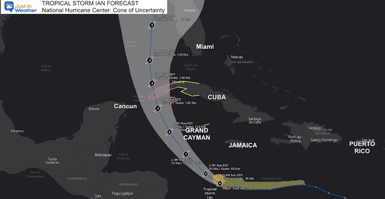
Forecast Track/Cone: National Hurricane Center
I need point out that the last couple of storms, including Fiona, trended to the LEFT side of the initial track. If we see that same bias with Ian, it could make a big difference in the potential intensity and where it ends up in the US.
CLOSE MAP
Tropical Storm Warning for Grand Cayman, Hurricane Watch for western Cuba. Cancun looks to stay just on the edge of the storm, which happens to be the weaker side of the storm.
NHC Forecast Notes are below the Interactive Wind Widget
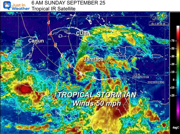
WIDE MAP
It has already shifted farther West from the initial forecast, so this is not a lock for Tampa. I expect some adjustment…
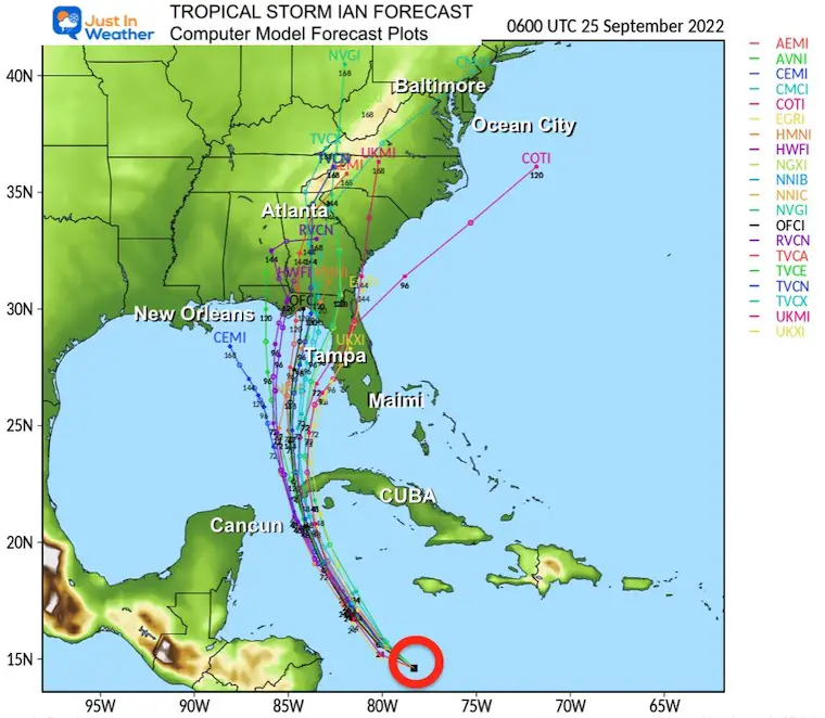
Forecast Computer Model Plots:
North inland push, then it will lose its tropical characteristics. This is when it will push inland and bring heavy rain up to the Mid Atlantic.
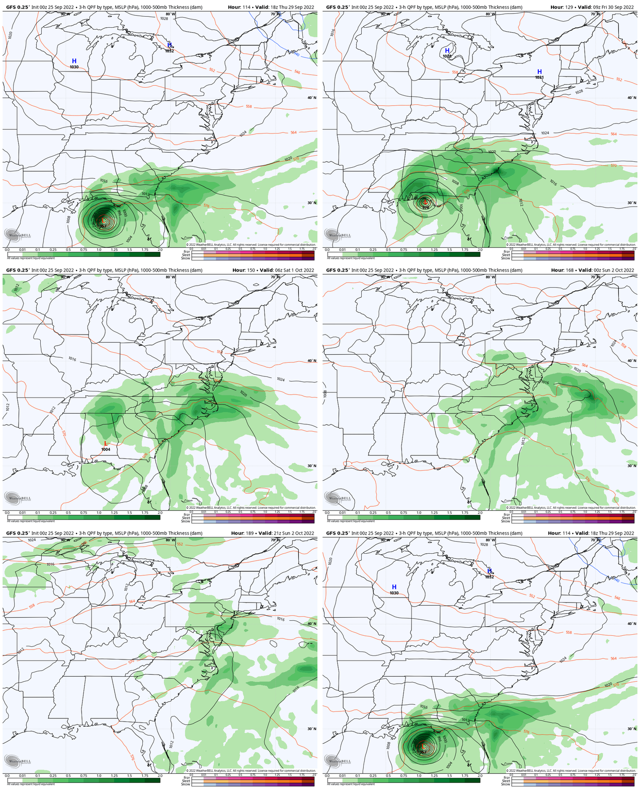
Looking Ahead To The US Landfall And Inland
The GFS Model seems to be the best at handling the shift farther west, and it continues to track on the west or LEFT side of the Cone of Uncertainty. This shows landfall on the Florida Panhandle, which is much farther west than the NHC initial forecast south of Tampa.
This will allow more moisture to push farther north…
Rain is likely to reach the Mid Atlantic Saturday, and may last into Sunday morning. This is longer than I showed yesterday with this model, all based on the shift in landfall track.
There may be more adjustments as the storm gets better organized, so this is NOT locked in yet.
GFS Model Animation: Thursday Sep 29 to Sunday Oct 1
WIND WIDGET FORECAST
National Hurricane Center Forecast Notes:
WIND: Hurricane conditions are expected to reach Grand Cayman by early Monday, with tropical storm conditions expected by tonight.
Tropical storm conditions are possible on Little Cayman and Cayman Brac by tonight or early Monday.
Hurricane conditions are possible within the hurricane watch area in Cuba by Monday night or early Tuesday, with tropical storm conditions possible by late Monday.
Tropical storm conditions are possible within the tropical storm watch area in Cuba Monday night and Tuesday.
RAINFALL: Tropical Storm Ian is expected to produce the following rainfall:
Jamaica and the Cayman Islands: 3 to 6 inches, with local maximum up to 8 inches.
Western Cuba: 4 to 8 inches, with local maximum up to 12 inches.
Florida Keys to the southern and western Florida Peninsula: 2 to 4 inches, with local maximum up to 6 inches through Wednesday morning.
STORM SURGE: Storm surge could raise water levels by as much as 9 to 14 feet above normal tide levels along the coast of western Cuba in areas of onshore winds in the watch area Monday night and early Tuesday.
Storm surge could raise water levels by as much as 2 to 4 feet above normal tide levels along the immediate coast in areas of onshore winds in the Cayman Islands Sunday night into Monday.
Weather posts straight to your inbox
Sign up and be the first to know!
COMPARE TO THE PAST
If you want a snowy winter, this is what you might want to look for in the rest of the tropical season.
Rainbow Ice Cave In Mt. Rainier A Very Rare Find: Photos And Video
Hurricane Season Forecast: June 1 Through November 30
NOAA 2022 Hurricane Forecast- Above Normal Again
Related Posts
NOAA Study: Reducing Air Pollution INCREASED Tropical Storms
Atlantic Tropical History: Maps of Origin Regions Every 10 Days
Please share your thoughts, best weather pics/videos, or just keep in touch via social media
-
Facebook: Justin Berk, Meteorologist
-
Twitter: @JustinWeather
-
Instagram: justinweather
STEM Assemblies/In School Fields Trips Are Back
Click to see more and ‘Book’ a visit to your school


