


April 27 Weather Chilly With Showers Then Turning Up The Summer Heat
Saturday, April 27 Morning Report One day to get through before the surge of summer heat. Today, we get clouds and rain showers as a warm front approaches. But on…
Sunday September 18
Morning Update
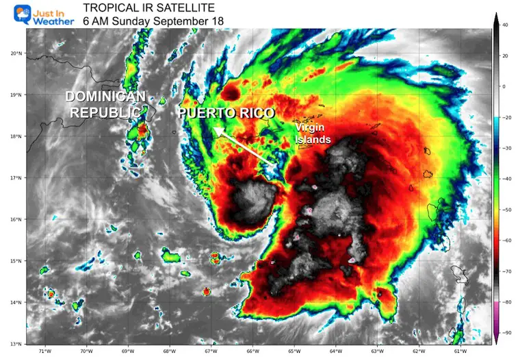
We start this day with Fiona still a tropical storm, but it is expected to intensify to a hurricane today before making landfall on Puerto Rico. On the satellite images we can see a developing eye in the center of circulation, showing better organization.
This development has increased the rainfall forecast. Puerto Rico will be seeing the worst conditions:
Storm Surge: 1 to 3 Feet!
Rainfall: 6 to 12 inches of rain likely, but southern parts of the island may see up to 25 inches enhanced by the mountains! Yes, over 2 feet of rainfall is possible with this storm in some spots! Devastating flooding, mudslides and widespread long lasting power outages are very possible.
Below is a live radar centered on Puerto Rico to plot and compare to the forecast maps.
(The website has been having issues with some GIFs, so I have embedded this loop from my Twitter feed)
#Fiona satellite loop Sunday Morning.
This is expected to become a hurricane today as it crosses Puerto Rico.
Rainfall Forecast: 12 to 16 inches, UP TO 20 INCHES pic.twitter.com/A0N2fymCtz— Justin Berk (@JustinWeather) September 18, 2022
Before sunrise, the center of the storm was located 80 miles south of St. Croix and 80 miles Southeast of Ponce, Puerto Rico.
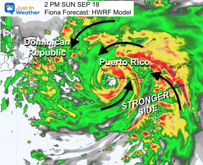
The stronger side of the storm is on the RIGHT OF CENTER. This is the portion that will cross over Puerto Rico today!
Winds are 65 mph
Moving to the WNW 8 mph (slowed down from yesterday)
Tropical Storm Force Winds Extend 140 miles from the center
A weather station at Teagues Bay, St. Croix recently reported a wind gust of 59 mph (94 km/h). A wind gust of 55 mph (89 km/h) was recently reported at Henry E. Rohlsen Airport on St. Croix.
The estimated minimum central pressure based on earlier aircraft data is 994 mb (29.36 inches).
From NOAA/National Hurricane Center
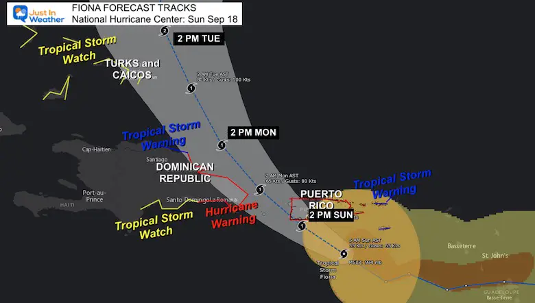
SUMMARY OF WATCHES AND WARNINGS IN EFFECT:
A Hurricane Warning is in effect for…
* Puerto Rico, including Vieques and Culebra
* The coast of the Dominican Republic from Cabo Caucedo to Cabo Frances Viejo
A Hurricane Watch is in effect for…
* U.S. Virgin Islands
* North coast of the Dominican Republic from Cabo Frances Viejo westward to Puerto Plata
A Tropical Storm Warning is in effect for…
* U.S. Virgin Islands
* British Virgin Islands
* North coast of the Dominican Republic from Cabo Frances Viejo westward to Puerto Plata
A Tropical Storm Watch is in effect for…
* South coast of the Dominican Republic west of Cabo Caucedo to Barahona
* Turks and Caicos Islands
* Southeastern Bahamas
Compare to the forecast model plot below.
The stronger side of the storm is on the RIGHT OF CENTER. This is the portion that will cross over Puerto Rico today!
Note that this model had the track on Puerto Rico yesterday, while the NOAA forecast was west into the Dominican Republic. This has been the best performer.
RAINFALL: Fiona is forecast to produce the following rainfall:
Leeward Islands: Additional 2 inches or less.
British and U.S. Virgin Islands: 4 to 6 inches, maximum of 10 inches on St. Croix.
Puerto Rico: 12 to 16 inches with local maximum of 25 inches, particularly across eastern and southern Puerto Rico.
Northern and Eastern Dominican Republic: 4 to 8 inches with local maximum 12 inches, particularly near the far east coast.
Rest of Dominican Republic and Haiti: 1 to 3 inches.
Turks and Caicos: 3 to 6 inches.
These rains will produce life-threatening flash flooding and urban flooding across Puerto Rico and the eastern Dominican Republic, along with mudslides and landslides in areas of higher terrain.
STORM SURGE: The combination of storm surge and the tide will cause normally dry areas near the coast to be flooded by rising waters moving inland from the shoreline. The water could reach the following heights above ground somewhere in the indicated areas if onshore winds and the peak surge occur at the time of high tide…
Southern coast of Puerto Rico…1 to 3 ft
Vieques and Culebra…1 to 3 ft
U.S. Virgin Islands…1 to 2 ft
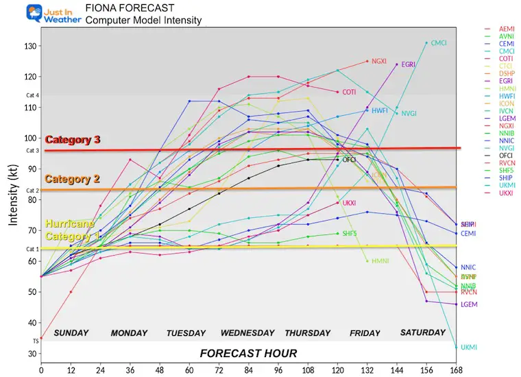
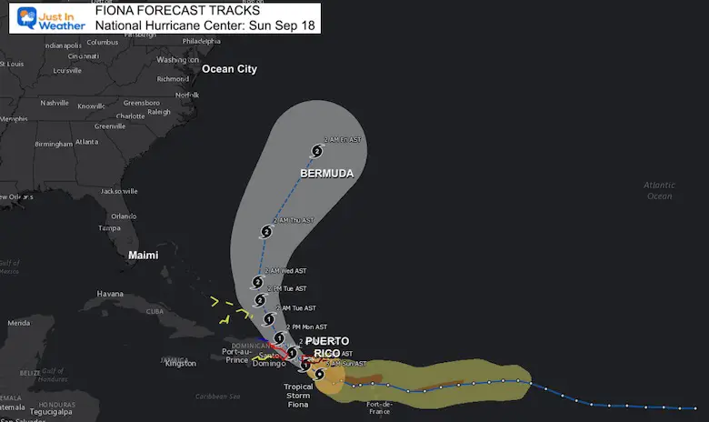
There is NOW a lot more support for this to reach at least become a Category 2 Hurricane AFTER passing north of Puerto Rico.
Most ensembles show this curving through the Bahamas then east of the US coast towards Bermuda. While it may miss the US east coast, it will produce dangerous rip currents and beach erosion through the Mid Atlantic shoreline.
INTERACTIVE WIND FORECAST: NHC Forecast
Use the slider at the bottom of the viewer to adjust the time. You can adjust the view to zoom in or pan the map.
Atlantic Tropical History: Maps of Origin Regions Every 10 Days


NOAA Study: Reducing Air Pollution INCREASED Tropical Storms

If you want a snowy winter, this is what you might want to look for in the rest of the tropical season.
Record August For No Named Tropical Storms: Closer Look At Snow Following
NOAA 2022 Hurricane Forecast- Above Normal Again


Click to see more and ‘Book’ a visit to your school
