


May 2 One More Hot Day Then The Cool Down And Rain For The Weekend
Thursday May 2 Morning Report This is one of those days where we get a little surprise. The old air mass is holding strong and will allow one more hot…
Thursday September 15, 2022
Evening Update
In this record breaking slow hurricane season, we are in the peak timing and just one day ago got our 6th named storm. Warnings are in place for the Leeward Islands and Watches have been issued for the Virgin Islands and Puerto Rico. Up to 10 inches of rain may fall there. I swear my headline is PG! See below.
Tropical Storm Fiona rapidly developed in one day, and reached 60 mph winds today. Then it hit a snag. The core circulation earlier today appears to have popped out and got dislodged from the Deep Convection (tall clouds with heaviest rain). This was captured on visible satellite with the thin view of clouds circulating and moving well west of the main moisture see below.
Naked swirl alert #Fiona pic.twitter.com/X7QnEf0jlr
— Mike Ventrice (@MJVentrice) September 15, 2022
This demonstrates the problem the Atlantic has had generating storms all season. There is a lot of wind sheer. Stronger upper level winds are blowing from the west, cutting the top off the storm, exposing the center, and limiting further intensification.


SUMMARY OF 800 PM AST…0000 UTC…INFORMATION
———————————————-
LOCATION…16.1N 56.1W
ABOUT 385 MI…615 KM E OF THE LEEWARD ISLANDS
MAXIMUM SUSTAINED WINDS…60 MPH…95 KM/H
PRESENT MOVEMENT…W OR 260 DEGREES AT 14 MPH…22 KM/H
MINIMUM CENTRAL PRESSURE…1005 MB…29.68 INCHES
A Tropical Storm Warning is in effect for…
* Antigua, Barbuda, St. Kitts, Nevis, Montserrat, and Anguilla
* Saba and St. Eustatius
* St. Maarten
* Guadeloupe, St. Barthelemy, and St. Martin
A Tropical Storm Watch is in effect for…
* Puerto Rico, including Vieques and Culebra
* U.S. Virgin Islands
* British Virgin Islands
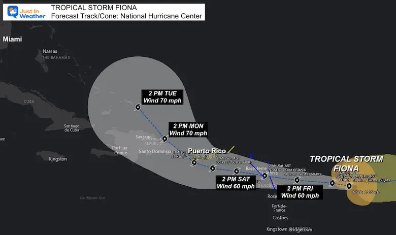
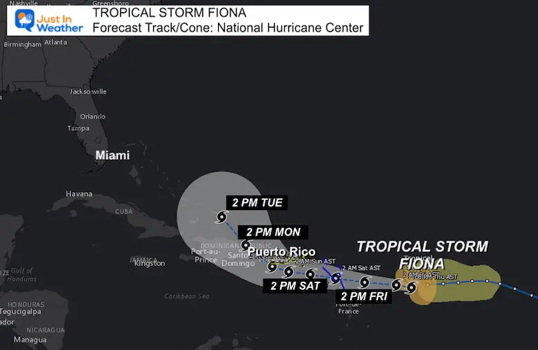
STORM SURGE: Localized coastal flooding will be possible along the coasts of the U.S. Virgin Islands and Puerto Rico in areas of onshore winds Saturday into Sunday.
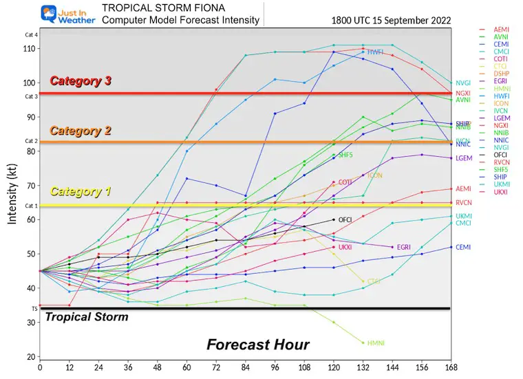
The majority of models keep this as a Tropical Storm. However, it should get better organized and regain more strength wrapping around the center again on Friday.
There are some models that show Hurricane intensity over this weekend, but that does not seem likely. Winds are most likely to remain at or below 65 mph.
The Tropical Storm is expected to reach the Virgin Islands and Puerto Rico this weekend.
RAINFALL: Fiona is expected to produce the following rainfall totals:
Leeward Islands, the British and U.S. Virgin Islands and Puerto Rico: 4 to 6 inches with isolated maximum totals of 10 inches across eastern Puerto Rico.
Eastern Hispaniola: 4 to 8 inches with isolated maximum totals of 12 inches.
These rains may produce flash and urban flooding, along with isolated mudslides in areas of higher terrain. Considerable flood impacts are possible across eastern portions of Puerto Rico.
While there is a lot that can change in 5 days, this is expected to curve north of Hispaniola and then become more of an interest for The Bahamas and Eastern US.
Atlantic Tropical History: Maps of Origin Regions Every 10 Days


NOAA Study: Reducing Air Pollution INCREASED Tropical Storms

If you want a snowy winter, this is what you might want to look for in the rest of the tropical season.
Record August For No Named Tropical Storms: Closer Look At Snow Following
NOAA 2022 Hurricane Forecast- Above Normal Again

