Now we get to narrow in on Part 2 of this storm. The winter event that has been advertised all week should live up to expectations. I can’t overstate this, so I hope the weather maps help tell the story. This is not hype or hyperbole. We truly expect a Flash Freeze along with extreme cold, high winds, and dangerously low wind chills.
This is a perfect storm of sorts for Christmas holiday traveling.Some still have their last day of school, while others are racing to do late holiday shopping, and many just want to leave town for the long weekend. In short, simply wait until afternoon. I know some schools that were scheduled have canceled early.
I should add that the Ravens are playing on Saturday, and it will be painful. The weather, I hope not the score!Cold air and strong winds will last into the weekend.
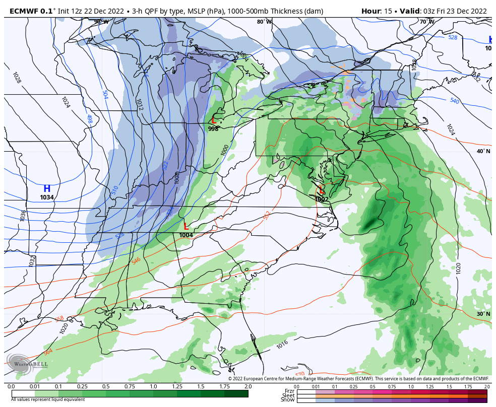
Bomb Cyclone:
10 PM Thu to 10 PM Fri
If you missed my explanation in a prior post, this is a legitimate term and on display. Low Pressure is dropping MORE THAN 24 mb in 24 hours. That results in a Wind Machine which we will feel as it funnels arctic air to the Atlantic Coast!
Below I will highlight the Two Alert Maps, then share some notes, my new Winter Profile Maps, followed by all the weather maps to help show how this will play out.
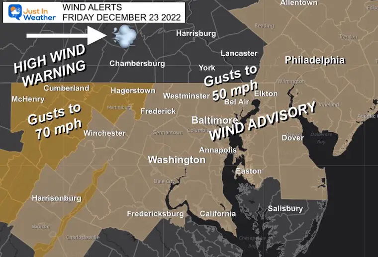
Wind Advisory and High Wind Warning
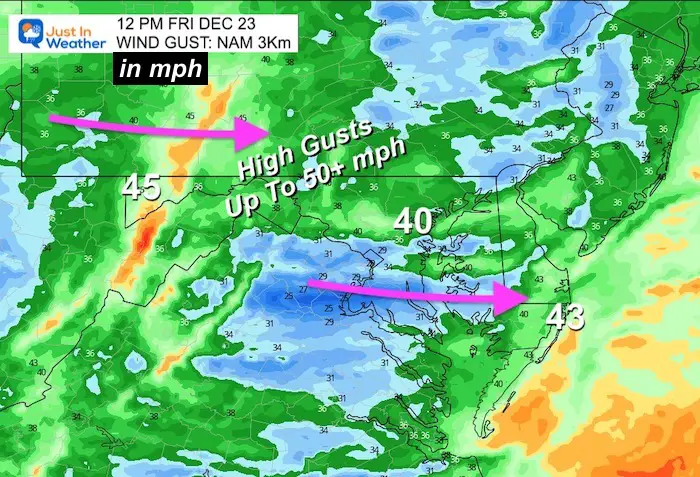
Yes, Winds may reach 50 mph in metro areas.
Up to 70 mph in the mountains.Wait until you see the temps and wind chills.
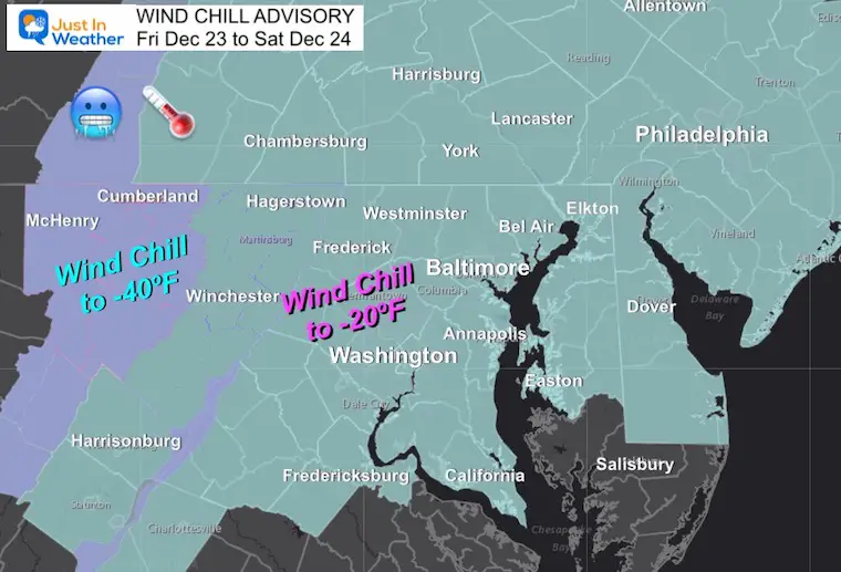
Wind Chill Advisory and Warning
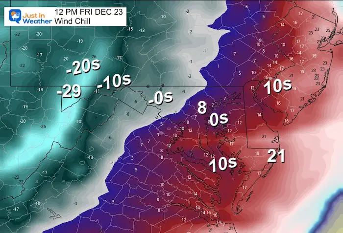
Many urban and metro areas may reach from 0 to -20ºF at times Friday and Saturday.
The high mountains over 2,000 Ft may reach wind chills (at times) as low as -70ºF. That is an official NWS alert!
Arctic Front
The transition will be the worst part. Rain will turn to snow for most. It may only last a half hour to up to 2 hours.The total may be just a dusting up to 1 inch (with more in the mountains).But simply having a wet ground as temps drop into the lower 20s and teens within an hour or two is why I have been pushing for caution.
Timing and Travel
The timing of the arrival has been speeding up, which is to be expected with such a deep and dense air mass. This will be in the morning and reaching the coast by noon. If you are concerned about travel, I would simply say wait this out.Let this pass through in the morning, and then just deal with the strong winds and bitter cold later in the day. The sun may actually come out.
Winter Travel Profiles
My initial goal for these graphics were to show snow variability. But in this case, the timing of the arctic front may help.Note that STRONG WINDS will persist AFTER the front passes.
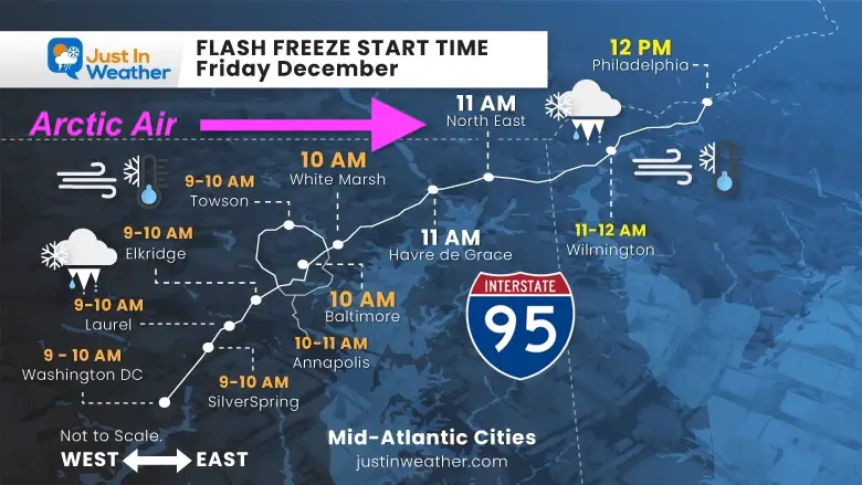
I-95 – Mid Atlantic Cities
This is for travel between Washington, Baltimore, and Philadelphia.
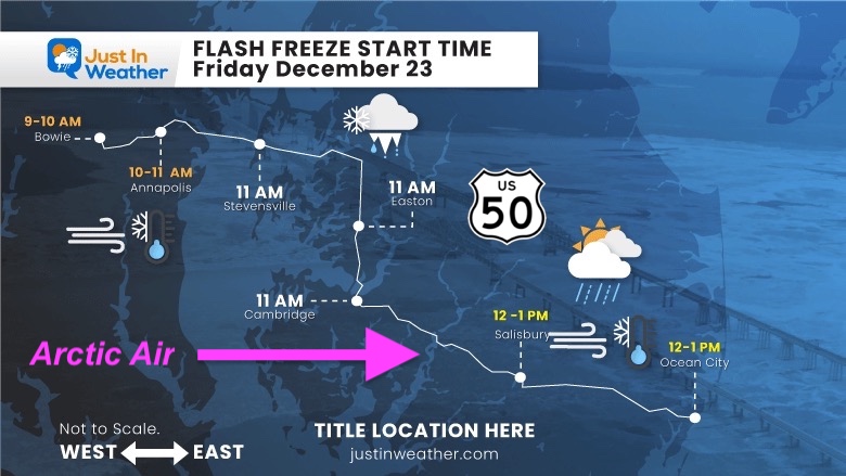
Maryland/US-50
This is for travel between Annapolis and Ocean City in Maryland. The Bay Bridge is likely to have restrictions due to the wind late morning and the rest of the day.
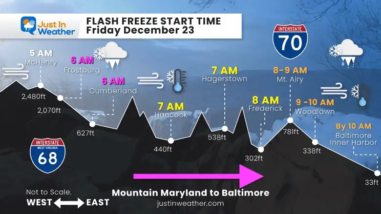
Western Maryland I-70 to I-68
Please compare my timing to the model simulation below.
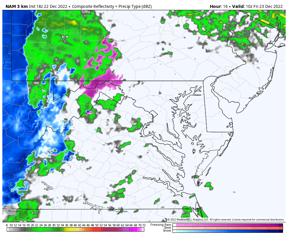
Radar Simulation NAM 3Km Model
Friday 5 AM to 2 PM
I have single individual time stamps below.
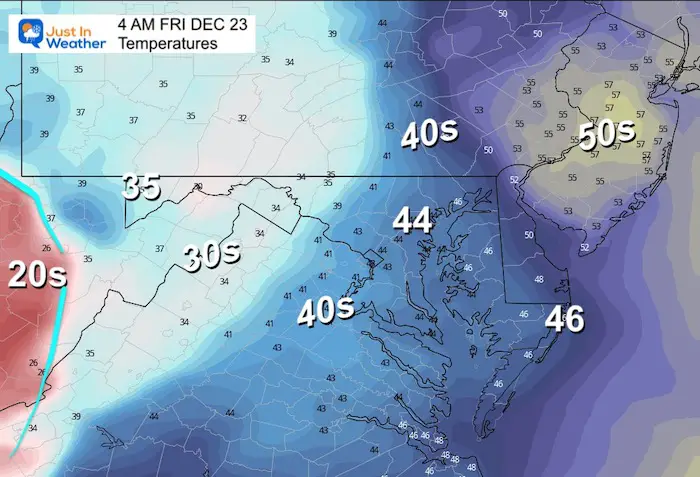
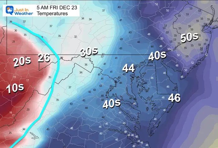
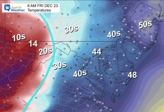
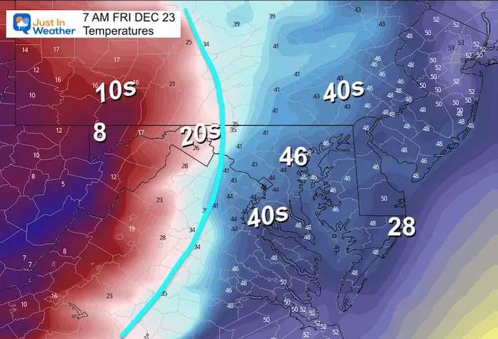
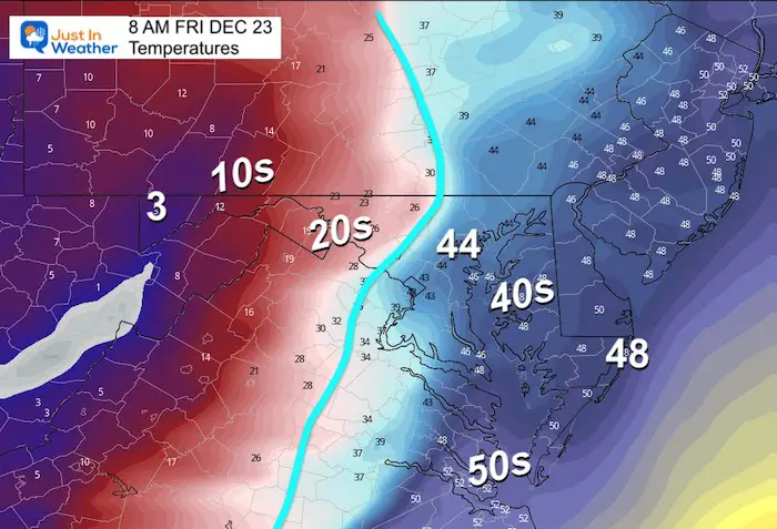
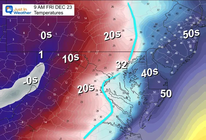
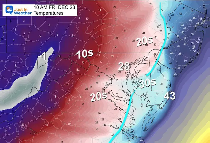
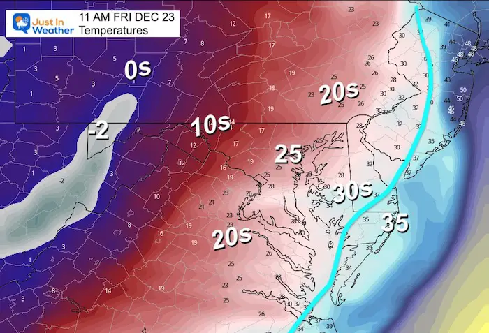
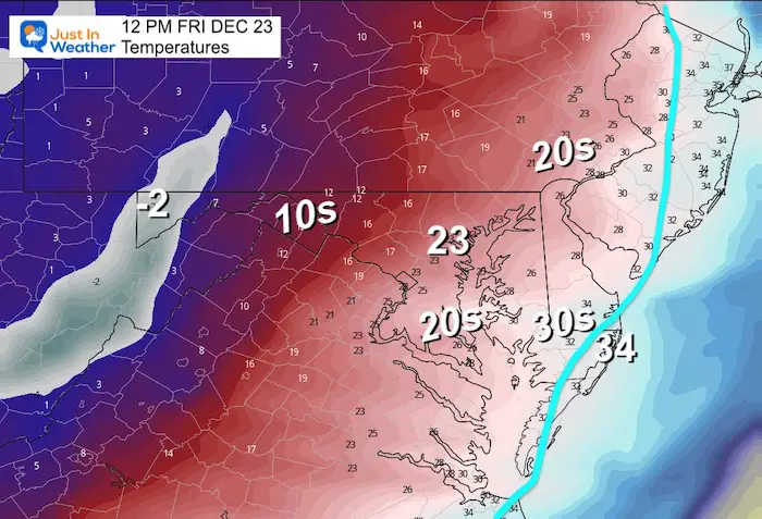
Temperature Timeline —> Slider
It’s been a while since I posted one of these, but I figured it would be easier for you to scan the timing by swiping left and right to see when the Freezing Line is expected to pass near you AND how quickly temps will drop!
december-23-temperatures-freeze-friday-4-am
december-23-temperatures-freeze-friday-5-am
december-23-temperatures-freeze-friday-6-am
december-23-temperatures-freeze-friday-7-am
december-23-temperatures-freeze-friday-8-am
december-23-temperatures-freeze-friday-9-am
december-23-temperatures-freeze-friday-10-am
december-23-temperatures-freeze-friday-11-am
december-23-temperatures-freeze-friday-12-pm
Noon
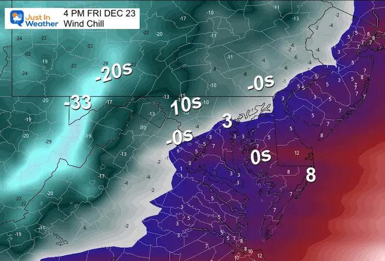
Wind Chill
It will start feeling like the single digits to well below zero!
Wind Gusts
At this point the front is off the coast, and winds will continue to gust and pulse the rest of the day!
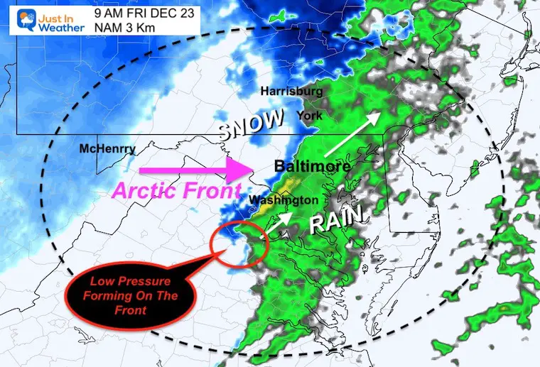
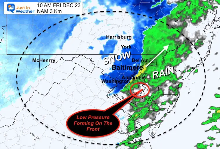
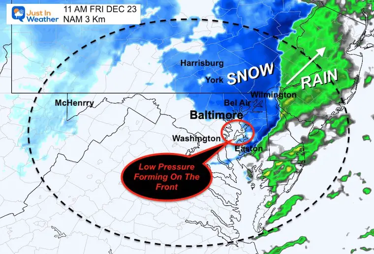
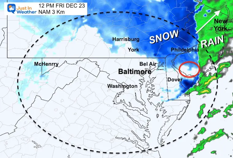
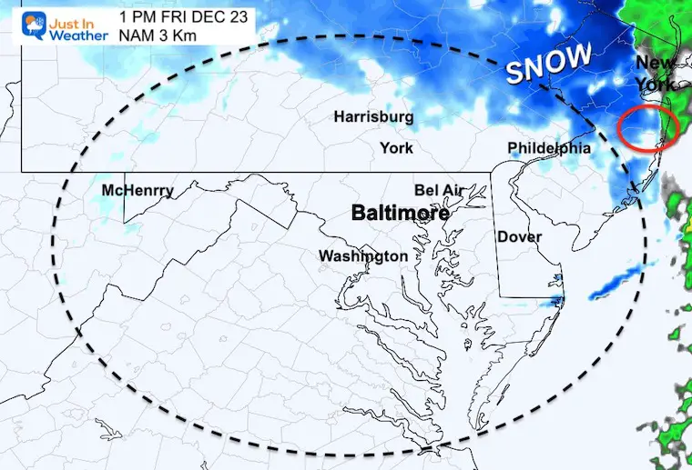
Let’s Back Up For The Fropa (Frontal Passage)
The reason for added moisture behind the front will be an attempt for Low Pressure to form along the front.I’ve plotted where it may play out. Please consider a buffer of an hour earlier or later than shown here, to allow for model error.
If this happens sooner, it may enhance the snow a little longer.That is why I gave the wide range of snow falling between 30 minutes and 120 minutes.
9 AM
10 AM
11 AM
12 PM
1 PM
Late Afternoon
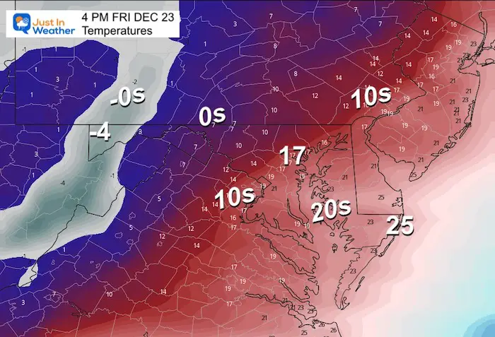
Temperatures
These are the EXPECTED readings on the thermometers. Even if this is over zealous and off by 5 degrees, this IS still VERY COLD!
Wind Chills
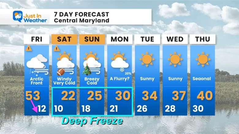
7-Day Forecast
We remain in the Deep Freeze through the Christmas Weekend. If you are going to the Ravens home game in Baltimore on Saturday, wear all the clothes you have!
Slow moderation next week back to seasonal temps at the end of next week.
In Case You Missed It:
In my prior report I answered two common questions about this event. Both will be validated over the next few days.
What is a Bomb Cyclone?
In short, a storm is low pressure, and a deeper storm has lower numbers of atmospheric pressure we measure in millibars (mb).When a storm gets stronger, the mb are lower numbers, which we say are ‘dropping’.
A Bomb Cyclone is defined as a storm dropping more than 24 mb in 24 hours, or more than 1 mb per hour for a day.See my report here for the maps that prove this.
What is a Flash Freeze?
This is when arctic air arrives and turns wet pavement to ice. We expect temperatures to drop midday Friday. The challenge is if pavement will remain wet as the temps drop, to allow ice to form on roads.Or, will the cold wind evaporate that wet pavement, drying up before it has a chance to freeze.
If you want a snowy winter, this is what you might want to look for in the rest of the tropical season. (You might be seeing a lot of commercial snow removal people out this Winter).