February 23 Aiming For Record Warmth Today Then Light Snow Saturday
February 23, 2023
Thursday Morning
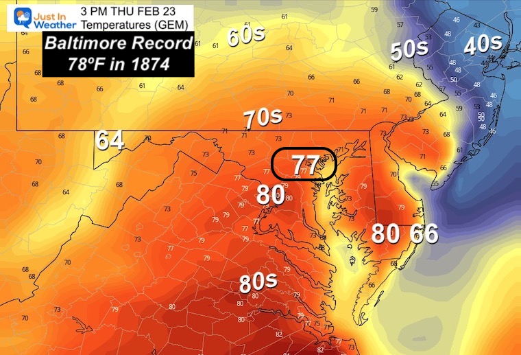
Today is the best representation of this winter. I mean with a major winter storm to our north where snow is being measured in FEET, and we are on the warm side. At this point it seems fitting to go for a warm record that is 149 years old! We will surge into the upper 70s, and some local areas could reach 80ºF.
This is only a ONE DAY THING! Temps will tank tonight and back to the chill tomorrow. Then there is that little system with light snow or flurries on Saturday. It is very practical to question any chance for stickage.
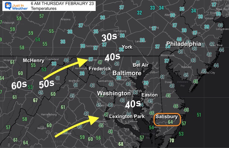
Morning Temperatures
If your kids want to wear shorts, keep in mind it is chilly this morning. The warm air will surge in by noon and beyond.
However, check out Salisbury, already in the 60s.
The warm air is already moving into the mountains…. That is where it will come from for most of us.
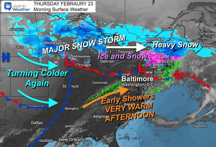
Morning Surface Weather
The major winter storm to our north is still raging and might be affecting travel. Up to 2 Feet of snow was expected for Minneapolis, one of their top 10 storms. Ice across lower Michigan, then more snow and ice through New York Sate and New England.
Locally: We shift the wind and PUMP IN NEAR RECORD HEAT!
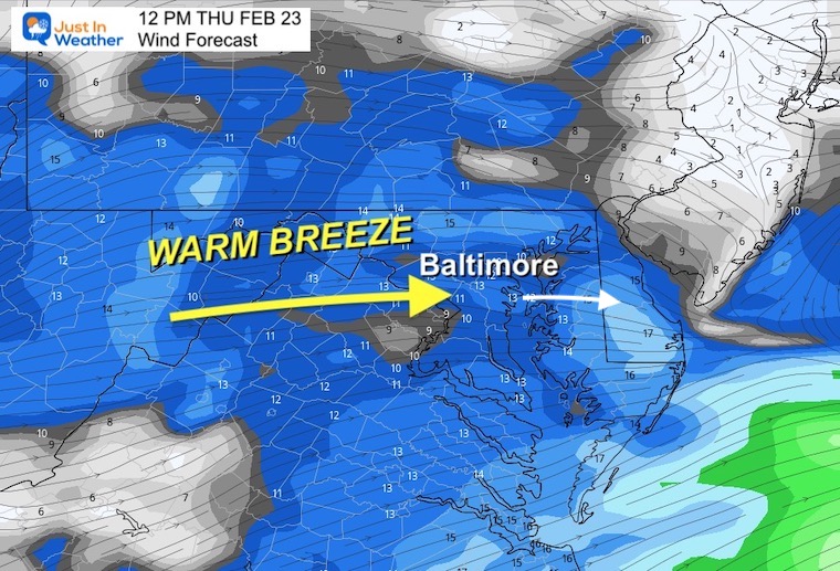
Wind Forecast
After an early shower and clouds break, the wind will increase from the West to Southwest. It will average 10 to 20 mph. With this direction, it may allow shoreline areas in Baltimore and Anne Arundel Counties to get in on the warmth and limit cooling from the Bay. However, the Eastern Shore coastline will be cooler with the wind off the water.
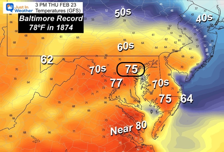
Temperatures
It was 78ºF in 1874 on Feb 23. 149 years ago!
I still believe we have a good chance to match it!
I am showing the two warmest model plots simply because the others are having trouble adjusting to the rare set up today. We often end up with a warmer reading at BWI than models show in these set ups.
There will be some local thermometers that reach 80ºF.
Note:
This will NOT be the warmest February day for our region. The top spot was 83ºF in Baltimore on February 25 in 1930.
GFS Model Forecast
Canadian GEM Model
I usually reserve showing this for arctic set ups and wintry weather, but this is the WARMEST plot of the model package.
Subscribe for eMail Alerts
Weather posts straight to your inbox
Sign up and be the first to know!
CLIMATE DATA
TODAY February 23
Normal Low in Baltimore: 28ºF
Record 5ºF in 1963
SNOW: 6.1” in 1987
Normal High in Baltimore: 48ºF
Record 78ºF 1874 <– This is the mark we may match or beat today.
Friday Weather
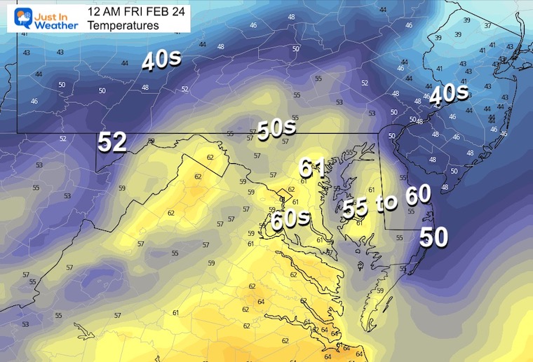
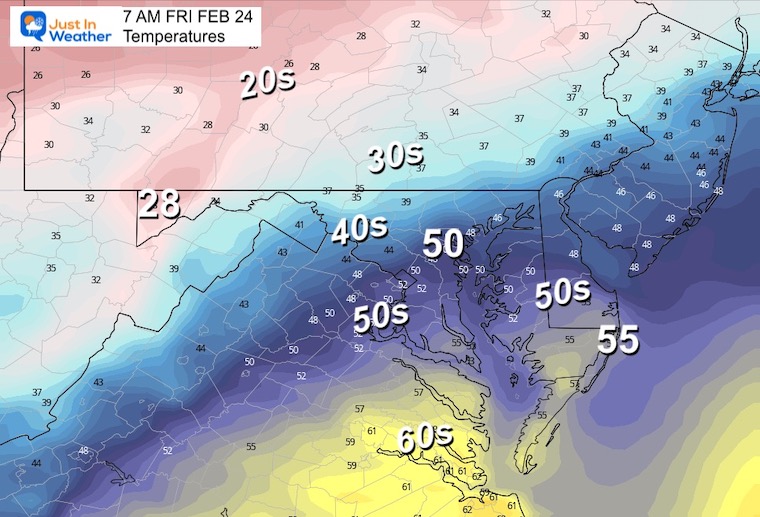
Windy and Colder! Temps will be falling overnight, then hold nearly steady during the day.
Temperatures
Midnight
This may be the warmest part of the day.
Morning
It will noticeably colder when you head out the door.
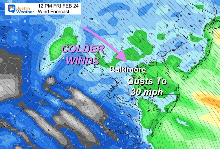
Wind Forecast: 7 AM to 7 PM
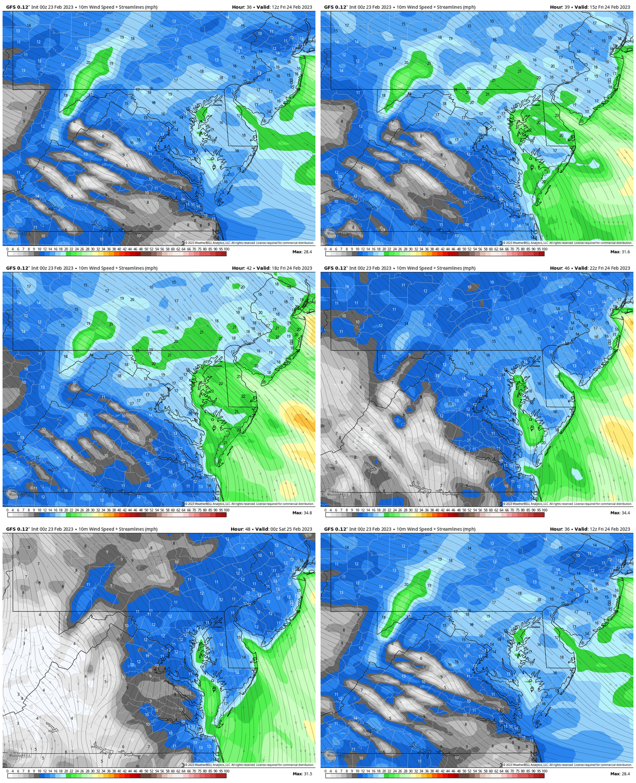
Mid Day Winds
The Northwest flow will average 10 to 20 mph, with gusts to 30 mph.
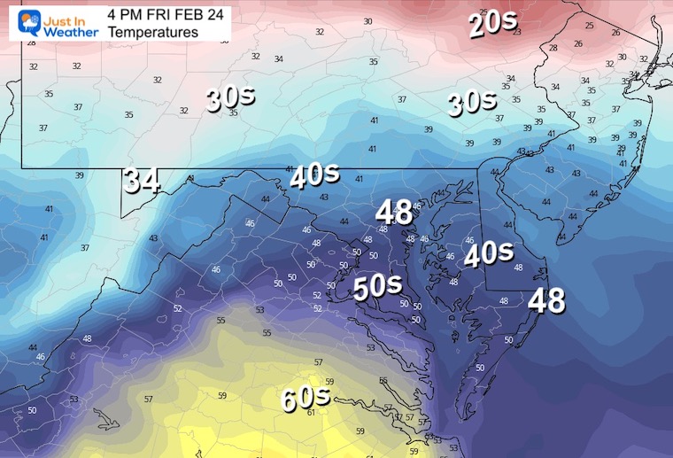
Afternoon
A bit of a reality check with temps holding in the upper 40s to near 50ºF.
Saturday Snow?
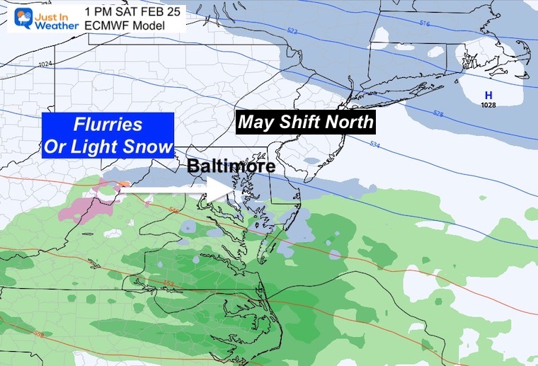
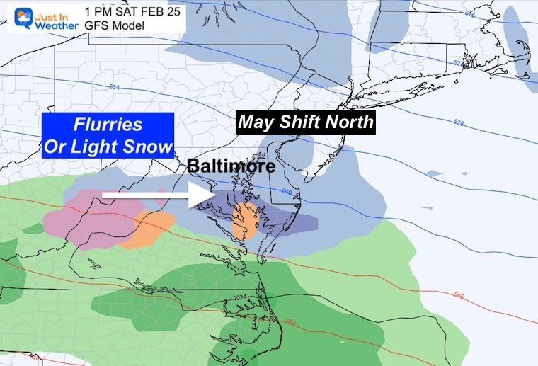
I get it, this is crazy! So let’s take this for what it is. This is more about just seeing it fall, rather than anything adding up on the ground.
I see the jet streak trying to produce a band of light snow or flurries. IF THIS HAPPENS it will be mid-day, and AFTER this warm day, so do not expect much to stick, let alone affect travel.
Compare the European and GFS Models. Both focus on southern Maryland. I expect these will shift back north like almost all other events this winter.
European ECMWF
GFS Model
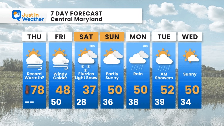
7 Day Forecast
A WILD SWING from heat today to some snow Saturday, then we settle back to where we were in the mild 50s.
Also See:
Winter History: Low Snow And Late Starts
See my research based on Baltimore data since 1883.
Subscribe for eMail Alerts
Weather posts straight to your inbox
Sign up and be the first to know!
STEM Assemblies/In School Fields Trips Are Back
Click to see more and ‘Book’ a visit to your school 
My Winter Outlook: Not A Typical La Niña!
I see many factors to support colder influence with multiple systems. Early and later in winter. Check it out. https://justinweather.com/2022/11/22/winter-outlook-2023-for-snow-not-typical-la-nina-plus-polar-vortex-disruption/
Also See The Winter Outlook Series:
Farmer’s Almanac Comparison
September Starts Meteorological Autumn: Weather Climate Stats For Maryland at Baltimore
Triple Dip La Niña Winter
https://justinweather.com/2022/09/09/winter-outlook-2023-la-nina-triple-dip-expectations/
CONNECTION TO WINTER?
If you want a snowy winter, this is what you might want to look for in the rest of the tropical season. https://justinweather.com/2022/08/31/record-august-for-no-named-tropical-storms-closer-look-at-snow-following/
Woolly Bear Caterpillars
https://justinweather.com/2022/10/25/winter-weather-outlook-from-the-wooly-bear-caterpillar/
Persimmon Seeds
Click to see Top 20 and MORE
Normals And Records: Maryland and Baltimore Climate History
Please share your thoughts, best weather pics/videos, or just keep in touch via social media
-
-
Facebook: Justin Berk, Meteorologist
-
Twitter: @JustinWeather
-
Instagram: justinweather
-


