February May Start Off More Wintry If We Follow The Euro Model
January 26, 2023
Thursday Evening Update
Do you remember the NOAA Outlook for early February was expecting the East Coast to be warm again? Well, that may not be the case if the European ECMWF Model has anything to do with it. We will take a look at what it is showing below.
I do agree with many who have been pessimistic about this winter:
- Where is that Polar Vortex?
- We need storms to track to our South and East.
Well, the model plots I will show you below have that starting to show up.
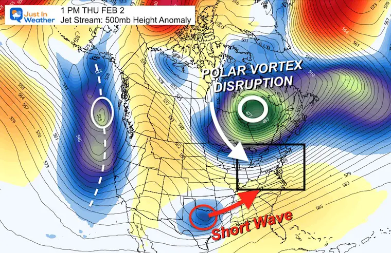
Jet Stream Next Week
The Polar Vortex is forecast to dislodge again and track into Eastern Canada by the end of next week. This is not a 2014 repeat visit to the US. It is however, a push of colder air and buckling of the jet stream. The timing will try to link up with more energy from Texas and move across the East Coast.
Temperature Outlook
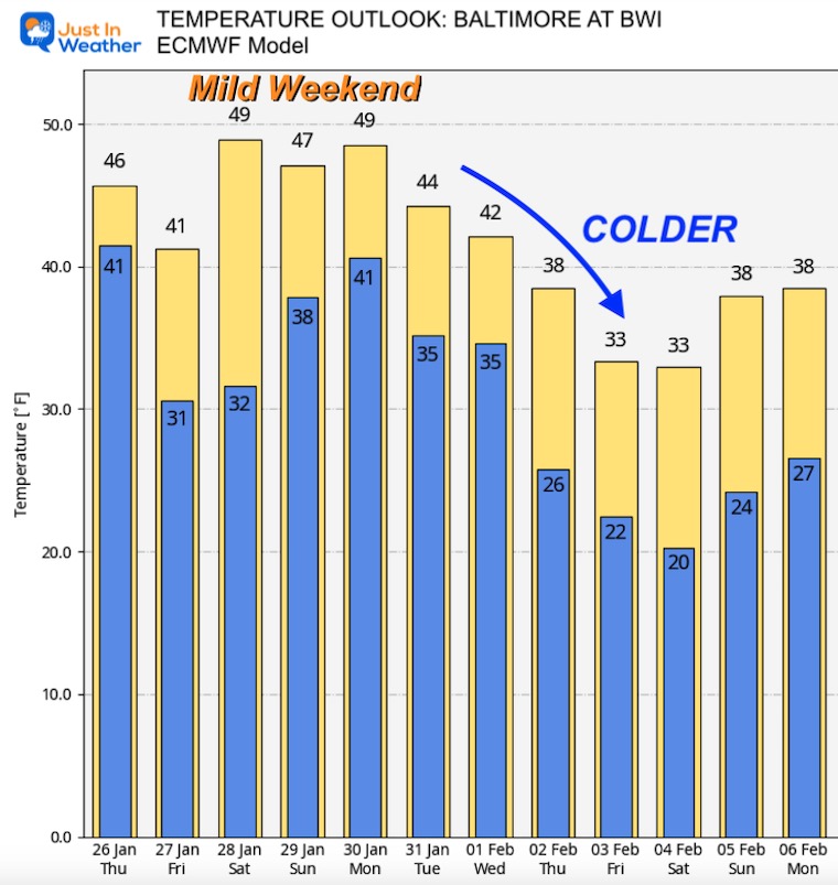
The European Model Ensemble shows our mild weekend (based in Baltimore), followed by falling temperatures next week. I do not like to take these numbers as definitive, but it does lean in the right direction if you want a change and snow. More on that below.
We are crossing the threshold to the back half of winter, and what should be prime time for snowstorms in the Mid Atlantic, but the season has not even started yet for the cities. As of today, Baltimore’s BWI snow drought holds the solo spot ranking 3rd latest for the first measurable snowfall. It is important to note the other dates on top of the list were in 1914 and 1973. This is rare, but it has happened before. Just a long time ago!
The next spot is February 6th set in 1914 and we have a chance to not beat that!
Latest Measurable Snow In Baltimore
Today Will Solo Place For 3rd Latest
- Feb 21 in 1973 (50 years ago)
- Feb 6 in 1914 (109 years ago)
- Jan 26 in 2023 (Today)
- Jan 25 in 1992 ( 31 years ago)
- Jan 25 in 1901 ( 122 years ago)
- Jan 23 in 1966 (57 years ago)
Desperate times are the reason for this post. I do hope as you read my weather updates, you understand I am sharing what I see, not wish-casting. I love snow and do not want to be disappointed. I have clients with businesses that rely on snow and they are quite anxious to have something to look forward to. So here we go:
Storm Animations Looking Ahead:
(I will show key snapshot below)
THESE ARE NOT FORECASTS: THESE ARE PROJECTIONS FROM ONE COMPUTER MODEL!
I EXPECT ADJUSTMENTS AS WE GET CLOSER.
THE PURPOSE NOW IS LOOKING TO TRACK FOR TRENDS, CONSISTENCY, OR FLIPPING.
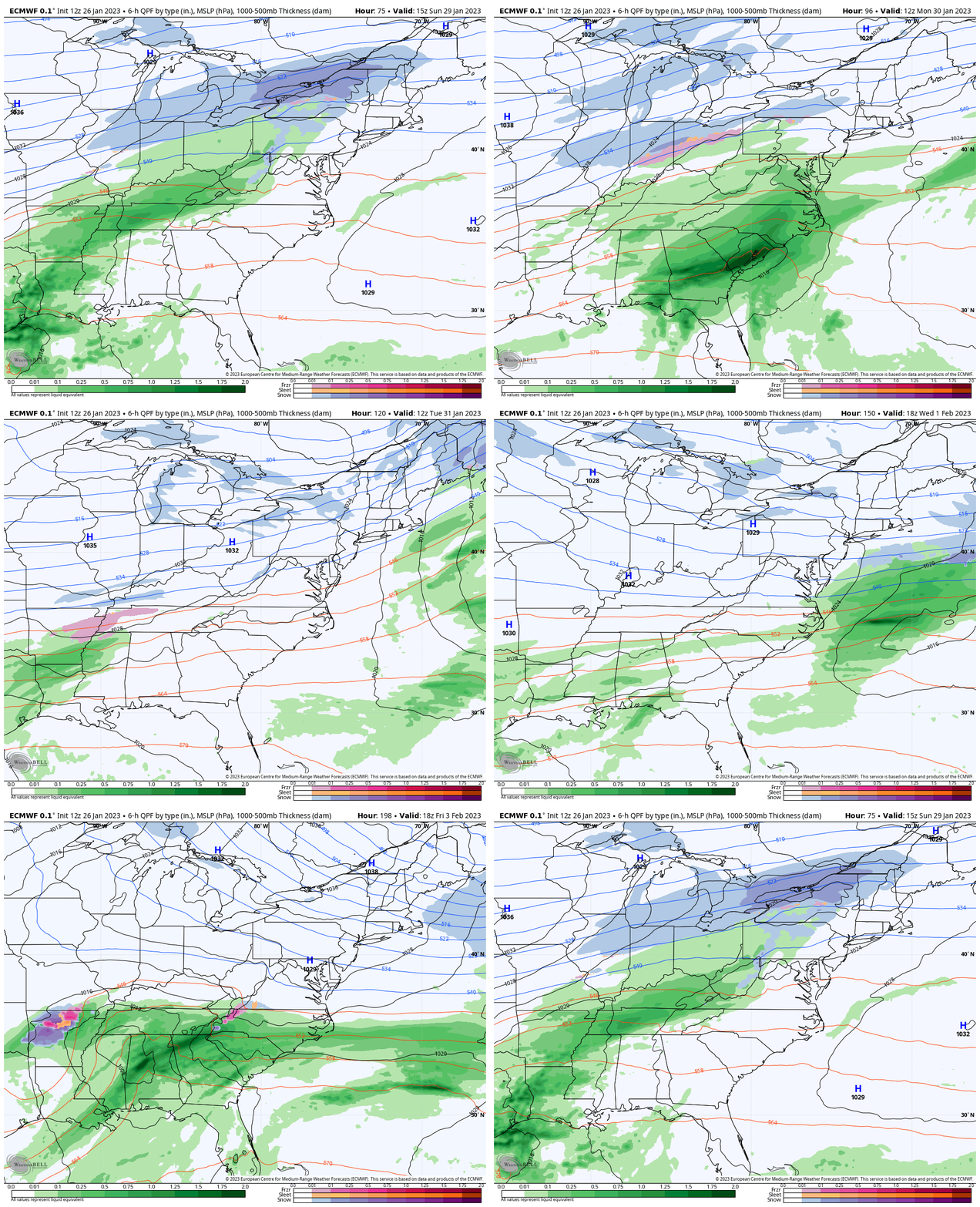
European ECWMF Model
Sun Jan 29 to Sat Feb 4
- Sun: Rain Showers
- Mon: Rain
- Wed: Light Snow
- Sat: Snow/Coastal Rain
GFS Model
We have established much less confidence in the GFS Model, but I will continue to show what may be on display in your weather app. This does show a different solution
Sun Jan 29 to Sat Feb 4
- Sun: Showers West
- Mon: Light Rain
- Tue: Snow South
- Thu: Snow South
- Sat: Cold and Dry (not a coastal storm)
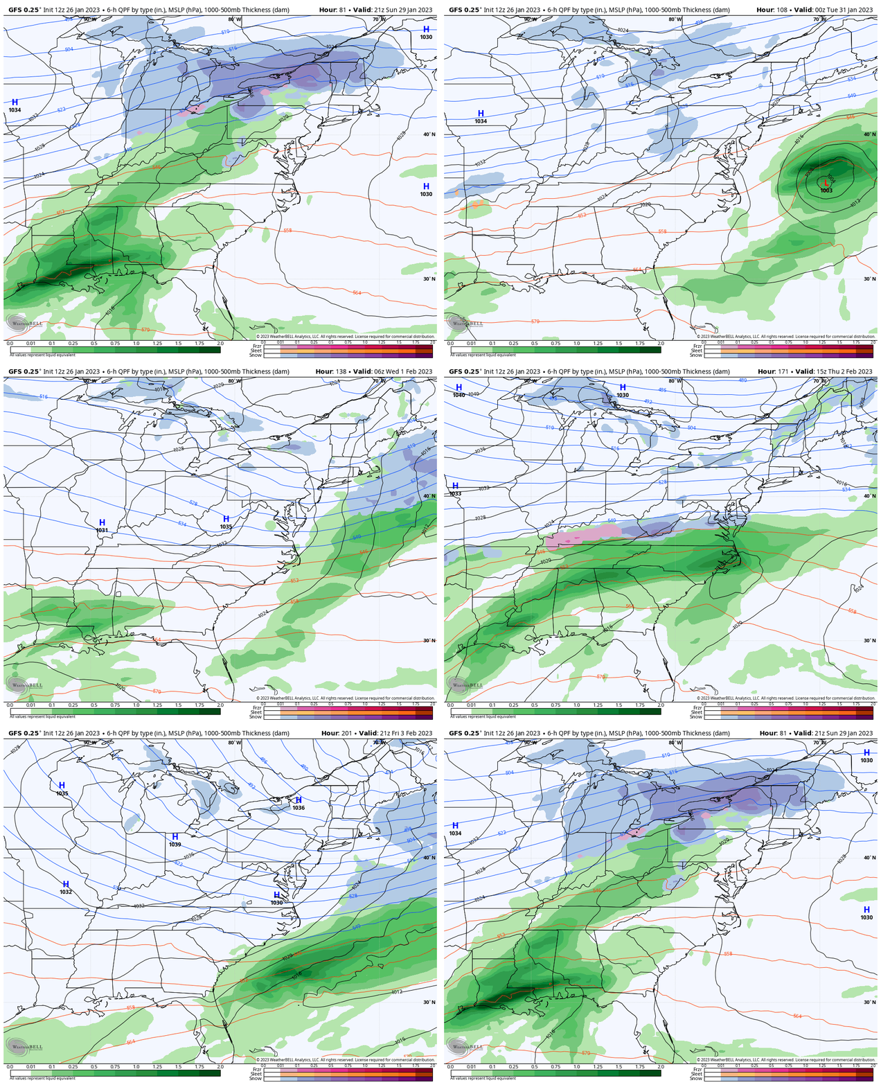
Question:
How can there be such a big difference?
Answer:
These models have a different set up of very complex calculations, putting weight on certain aspects in the atmosphere. A small difference early, can lead to a big variation further out in time.
The ECWMF Model has continued to be more reliable in this time frame, so I will focus the key time-frames on that product.
Key Snapshots:
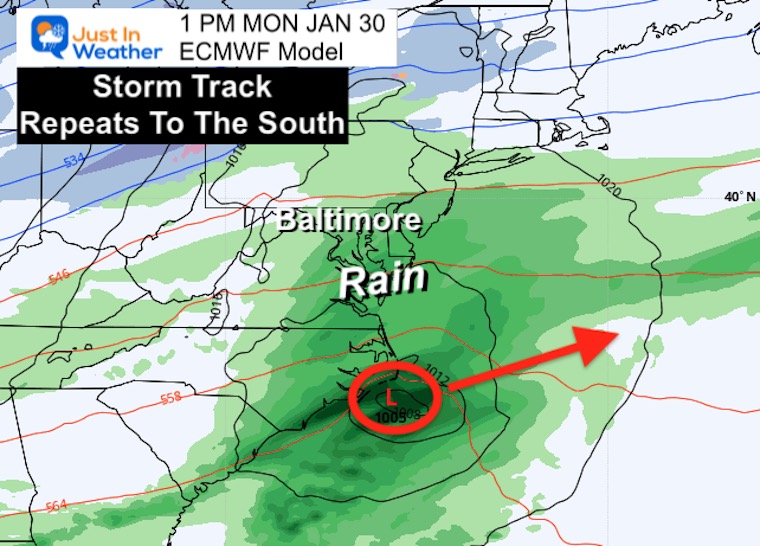
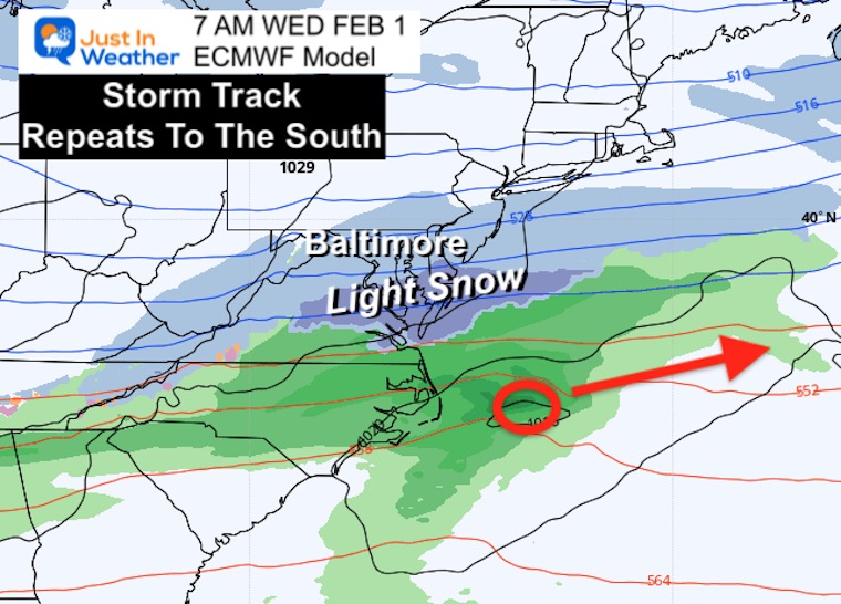
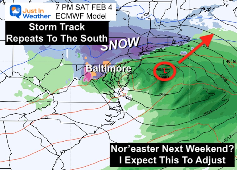
Notice the theme, that Low Pressure keeps tracking to our South-East!
Monday Afternoon
This will be rain event, with heavier rain farther south.
Wednesday Morning
I showed this system in my morning report. It has shifted farther south, but I expect more adjustments. The interest here is that it may help give a hint how this model is handling the atmosphere and if it can handle the next event that follows.
Next Saturday Morning Feb 4
Normally I would NOT show a Nor’easter more that one week ahead of time. But this is part of the cycle that will try to generate next week and helps tell the story.
I do expect this to adjust. As we get closer, the timing of elements may change when and how this storm can form. That could lean to a different day and track than shown here.
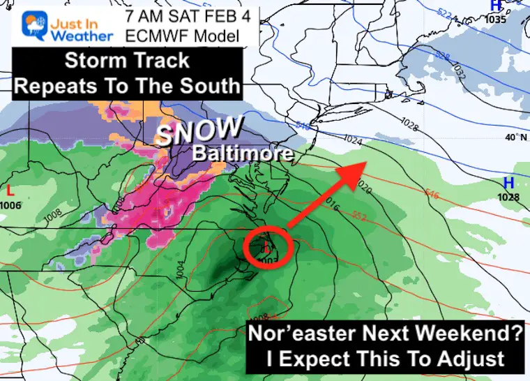
Next Saturday Night Feb 4
This is predicated on the storm actual forming as shown. It would likely be a classic snow inland and rain along the coast set up.
Take Away:
We are entering the prime time for our region to get snow, even in a winter lacking it. The outlooks simply sharing the ‘inside baseball’ of what us meteorologists are looking at with model displays. I do expect them to adjust. That can be anything from changing the timing, storm path, or intensity. I will be looking and showing you any consistency or trends.
Along the way I may share a little more depth and Geek Out. But for now, this is the show in town and I want you to have a front seat with me to watch how it will play out.
FITF.
Also See:
Winter History: Low Snow And Late Starts
See my research based on Baltimore data since 1883.
Subscribe for eMail Alerts
Weather posts straight to your inbox
Sign up and be the first to know!

STEM Assemblies/In School Fields Trips Are Back
Click to see more and ‘Book’ a visit to your school
My Winter Outlook: Not A Typical La Niña!
I see many factors to support colder influence with multiple systems. Early and later in winter. Check it out.
October 27 Nor’easter Recap Still Breezy Then Next Storm Friday
Also See The Winter Outlook Series:
October 27 Nor’easter Recap Still Breezy Then Next Storm Friday
Farmer’s Almanac Comparison
September Starts Meteorological Autumn: Weather Climate Stats For Maryland at Baltimore
Triple Dip La Niña Winter
CONNECTION TO WINTER?
If you want a snowy winter, this is what you might want to look for in the rest of the tropical season.
Rainbow Ice Cave In Mt. Rainier A Very Rare Find: Photos And Video
Wooly Bear Caterpillars
https://justinweather.com/2022/10/25/winter-weather-outlook-from-the-wooly-bear-caterpillar/
Persimmon Seeds
Click to see Top 20 and MORE
Winter Weather Folklore Top 20 And More Outlook Signals From Nature For Cold And Snow
Normals And Records: Maryland and Baltimore Climate History
Please share your thoughts, best weather pics/videos, or just keep in touch via social media
-
-
Facebook: Justin Berk, Meteorologist
-
Twitter: @JustinWeather
-
Instagram: justinweather
-


