Warm Return To Work With Rain Then Snow Will Try And Polar Vortex Disruption Next Week
Monday Evening January 2 2023
After this long holiday break, most return to work Tuesday morning and the weather still has some surprise I want to highlight here. This is simply to give you an idea of what is expected and may be happening ahead. If you are just getting back to the swing of things, I made this an easy and quick read. I also included my report on the Polar Vortex which is playing a big role with the warmth and planned pattern flip this month.
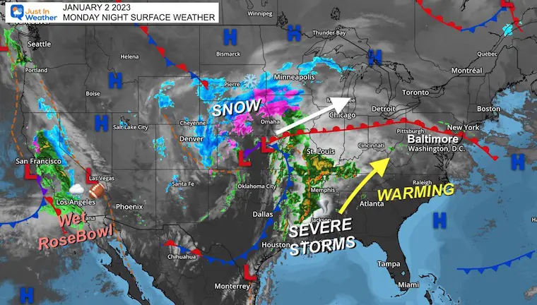
Monday Night Surface Weather
If you have been watching the Rosebowl and the Penn State ROMP, then you also heard about the rare rain in southern California. There is a very active storm track for the western US, tracking to the middle of the nation, then to our north. This is the simple reason why we are “warm”.
The central US storm is producing heavy snow from Denver to Iowa, while also igniting a severe storm outbreak in Arkansas and approaching St. Louis and Memphis.
Storm Animation
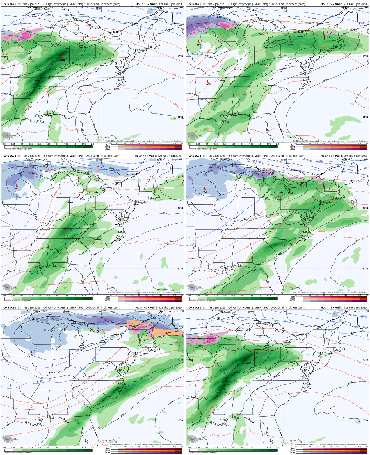
GFS Model 8 AM TUE to 8 AM THU
Low Pressure moves into New York and New England with two waves of rain for our region. Both will be more likely to reach the northern areas and leave the southern part lacking.
A closer look at that below.
Snapshots
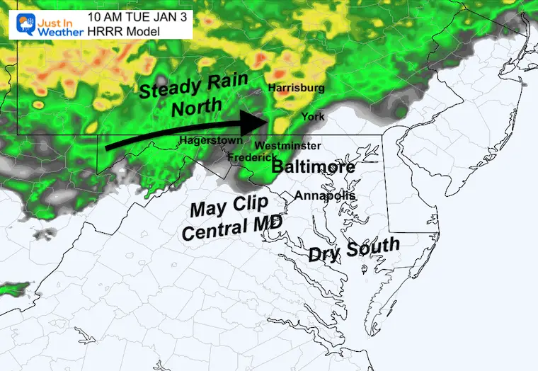
Tuesday
You may wake up with some fog and drizzle, but showers and steady rain are more likely to build in west and north of Baltimore. Heavier rain will fall across Southern Pennsylvania, including York and Lancaster before noon.
Farther south near Baltimore and Annapolis may miss out on this wave.
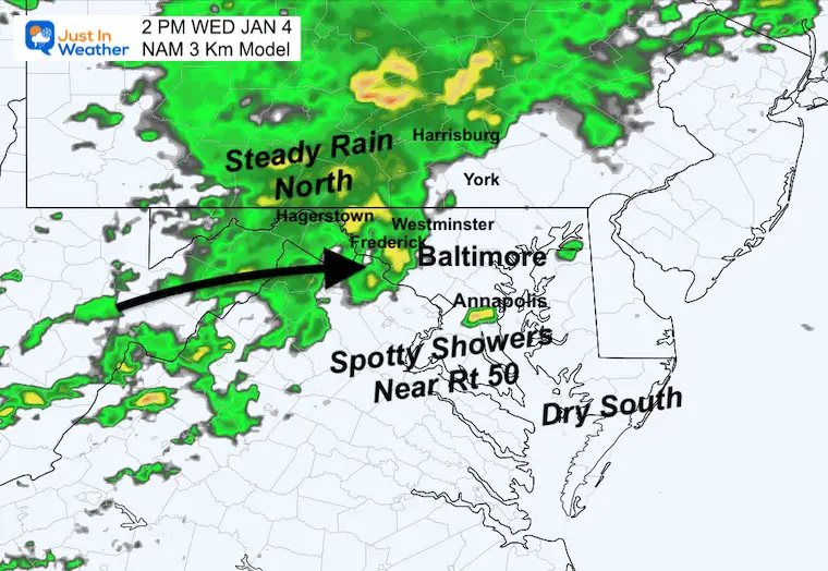
Wednesday
The next wave of showers will be during the day and afternoon. The same west and north areas are more likely to get steady rain. However, there will be spotty showers in central Maryland to shake things up.
It is possible to get some cells with rumbles of thunder.
Winter Weather Folklore: “If in winter there is thunder, snow may fall in one week or under”.
Next Phase: Thursday Evening To Sunday Morning
I mentioned the atmosphere will ‘try’ to do something but the ingredients are struggling to come together. At this point, that something may not be Friday, but Saturday night into Sunday we may develop some slushy snow.
This loop below ends at 7 AM Sunday January 8.
Note: I am not suggesting any impact at this time. The ground is still warm and I do not see substantial snow. But this does support the ski areas and ambience to remind you that winter is not done and trying to fight back.
Subscribe for eMail Alerts
Weather posts straight to your inbox
Sign up and be the first to know!
Polar Vortex Disruption Next Week?
If you missed my recent report, I explained why The Polar Vortex is wrapped up around the North Pole, but historical analogs in recent winters that put on a flip and winter display by the end of January.
Animation:
1 PM Tue Jan 3 to 1 PM Mon Jan 9
Here we can look at the Stratospheric Pressure Heights.
Over the next week, that tight Polar Vortex is expected to get a distortion to stretch out and bring colder air to the Eastern US.
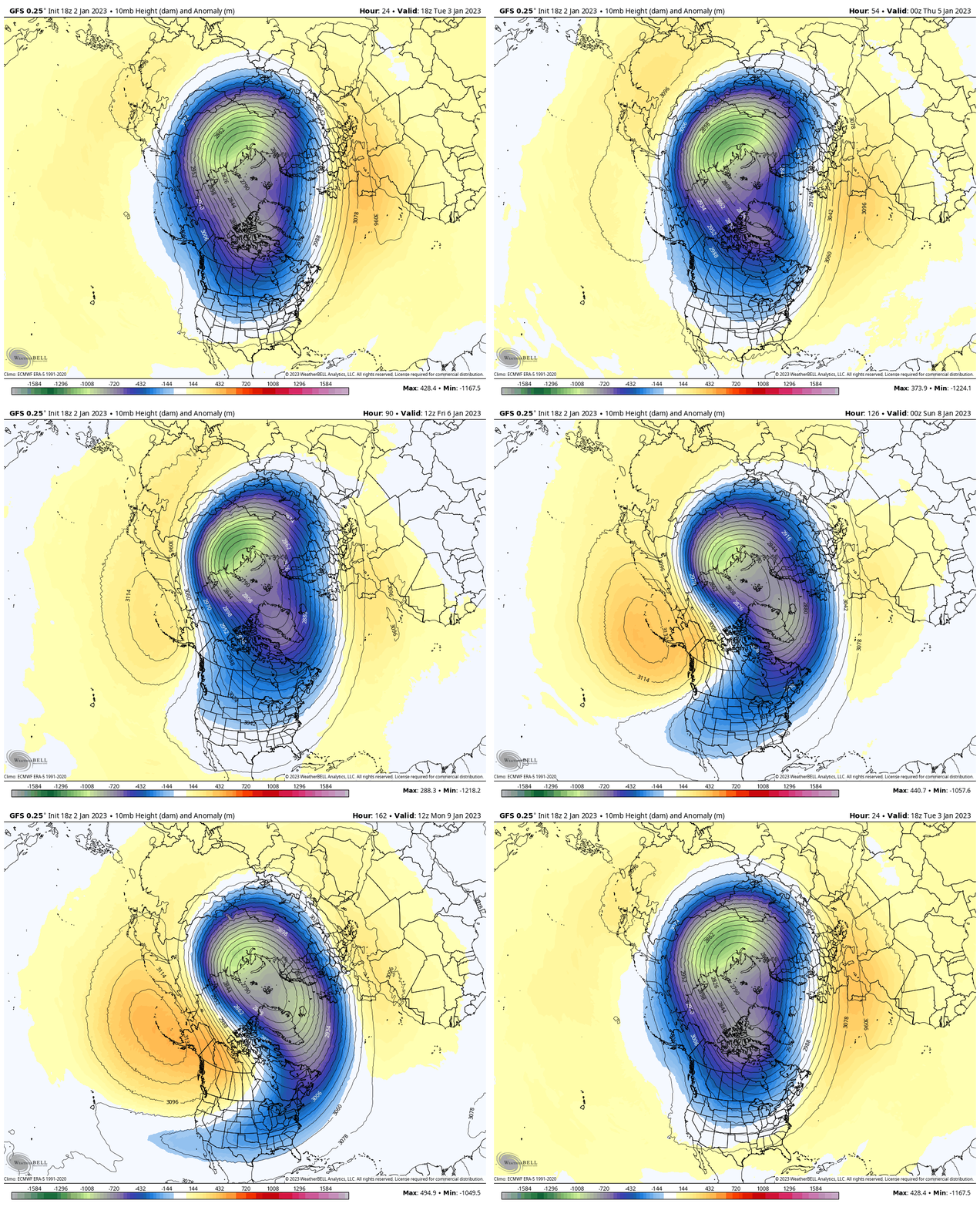
Snapshot: 1 PM Monday January 9
This view helps to show the stretched out heights expanding from the North Pole to the Eastern US. This is NOT an arctic blast like Christmas, but does bring colder air back our way.
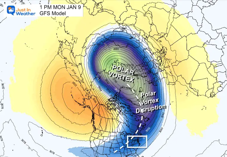
Closer Look
A large trough next week is NOT the full pattern change, rather the colder blip within a warm pattern I had been talking about. This is common and can produce some snow, but also help to further wobble the arctic air and bring on that pattern flip within a week or two after this passes.
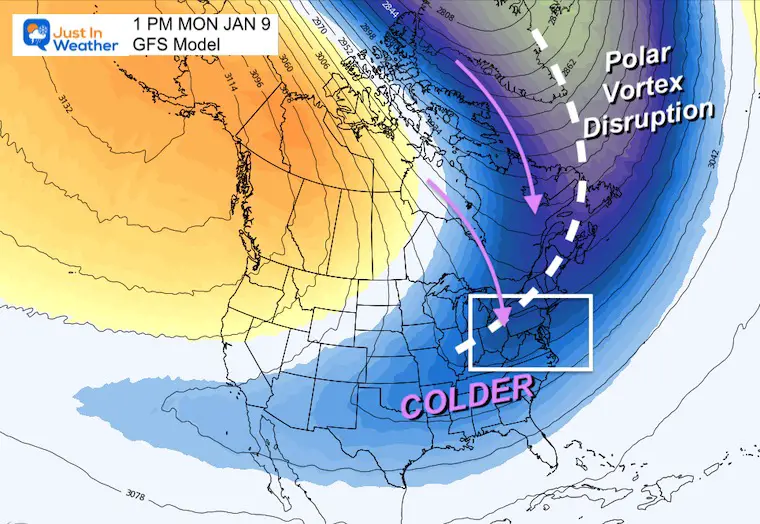
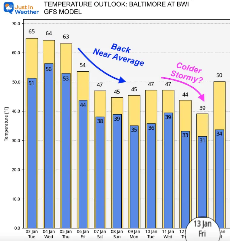
Temperature Outlook
GFS Model for Baltimore at BWI
I am only showing this model for the trend as a response to this pattern. WE will see a return to near normal temps this weekend, then an attempt for a colder surge by the end of next week.
NOTE:
I still refuse to put any confidence in surface weather plots more than 1 week away. However I do see a pattern like this that can support wintry events. It is on the horizon and well within normal expectations.
I know it is hard to believe for snow lovers, but I have Faith in the Flakes later this month.
I will have my full weather report Tuesday morning online by 6:30 AM. See you then.
FITF
Faith in the Flakes Gear
What is Faith in the Flakes?
It began with my son in 2009
October 27 Nor’easter Recap Still Breezy Then Next Storm Friday
SNOWSTIX – Available Now
STEM Assemblies/In School Fields Trips Are Back
Click to see more and ‘Book’ a visit to your school
My Winter Outlook: Not A Typical La Niña!
I see many factors to support colder influence with multiple systems. Early and later in winter. Check it out.
October 27 Nor’easter Recap Still Breezy Then Next Storm Friday
Also See The Winter Outlook Series:
October 27 Nor’easter Recap Still Breezy Then Next Storm Friday
Farmer’s Almanac Comparison
September Starts Meteorological Autumn: Weather Climate Stats For Maryland at Baltimore
Triple Dip La Niña Winter
CONNECTION TO WINTER?
If you want a snowy winter, this is what you might want to look for in the rest of the tropical season. (You might be seeing a lot of commercial snow removal people out this Winter).
Rainbow Ice Cave In Mt. Rainier A Very Rare Find: Photos And Video
Wooly Bear Caterpillars
https://justinweather.com/2022/10/25/winter-weather-outlook-from-the-wooly-bear-caterpillar/
Persimmon Seeds
Click to see Top 20 and MORE
Winter Weather Folklore Top 20 And More Outlook Signals From Nature For Cold And Snow
Normals And Records: Maryland and Baltimore Climate History
Please share your thoughts, best weather pics/videos, or just keep in touch via social media
-
Facebook: Justin Berk, Meteorologist
-
Twitter: @JustinWeather
-
Instagram: justinweather


