December 21, 2022
Wednesday Afternoon Update
I continue to focus on the speed of the storm, and it is starting to show why that is important. Like most of our Fall storms, this one will arrive a little earlier. This is thanks to the depth of the arctic air on the move.
Just a few hours earlier on Thursday morning has allowed this to catch up to the cold air in place to expand the expected snow and/or icing into parts of Central Maryland. If you are thinking of the event last week with freezing rain and wet roads, the surface temps have chilled a lot since then, especially with the last few nights in the teens and 20s.
This post has a focus on Part 1 – Thursday morning, but I also have an update on the Friday expectations as the arctic air, and Flash Freeze arrives before noon.
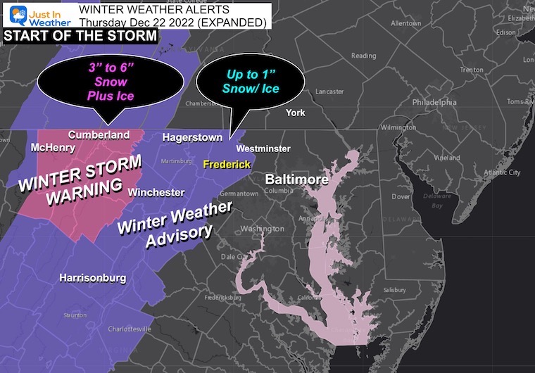
Winter Weather Alerts
Winter Weather Advisory: EXPANDED TO FREDERICK COUNTY. Also includes Hagerstown and Winchester, VA
Winter Storm Warning: Garrett, Allegheny Counties in Maryland, and surrounding higher mountains.
A New View
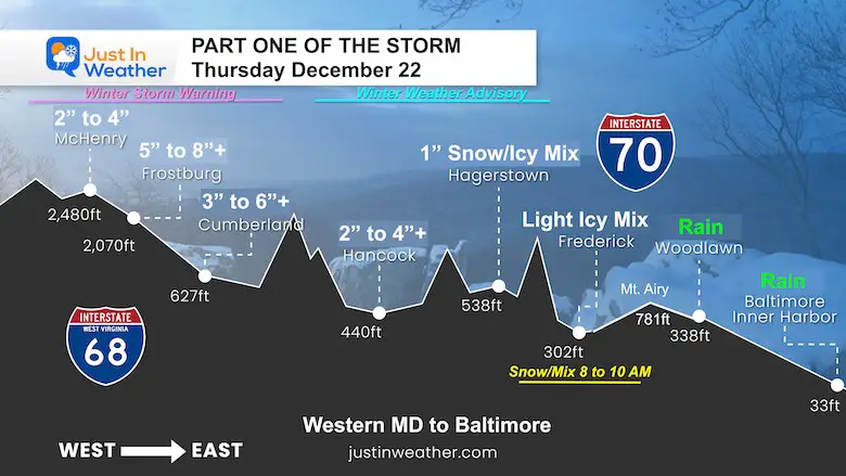
Storm Profile Thursday Morning
Western Maryland to Baltimore – Expectation on the highway or nearby roads.
*Thank you for letting me know you like this view; I am working with my artist on additional locations in time for the storm.
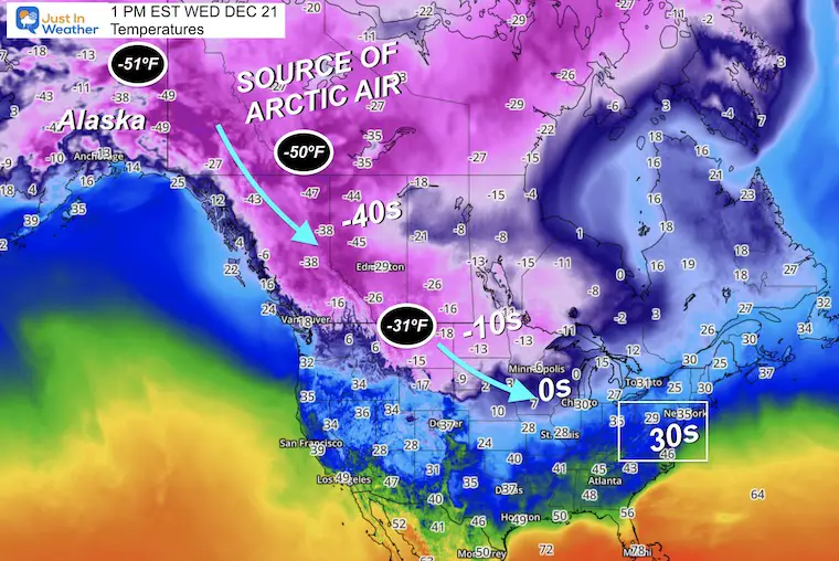
Source of Our Cold Air
Temperatures at 1 PM EST
Looking to western Canada and Alaska, there are some places at -50ºF, with -31ºF reaching northern Montana. Wind Chills there may drop to -70ºF.
It will not get that cold here, but it may feel like it (sort of) by Friday.
This arctic air is very cold and dense, which can move faster than models can identify. That is why our storm has been speeding up.
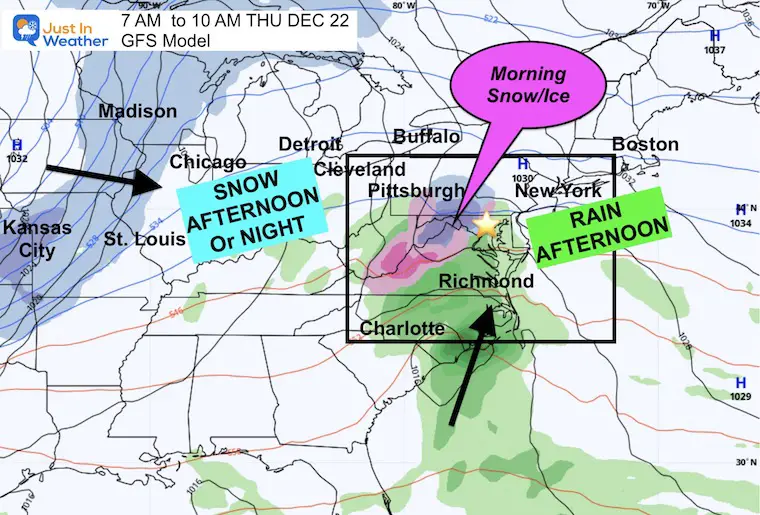
Thursday Morning – Eastern US
I have been asked for a wider map for travelers, and many expecting kids coming back from college.
The arctic front and heavy snow will reach Chicago to Detroit during the afternoon and at night.
We have our initial wave from the south with a little band of snow and ice, but the warmer air will win the first round. Let’s explore that below:
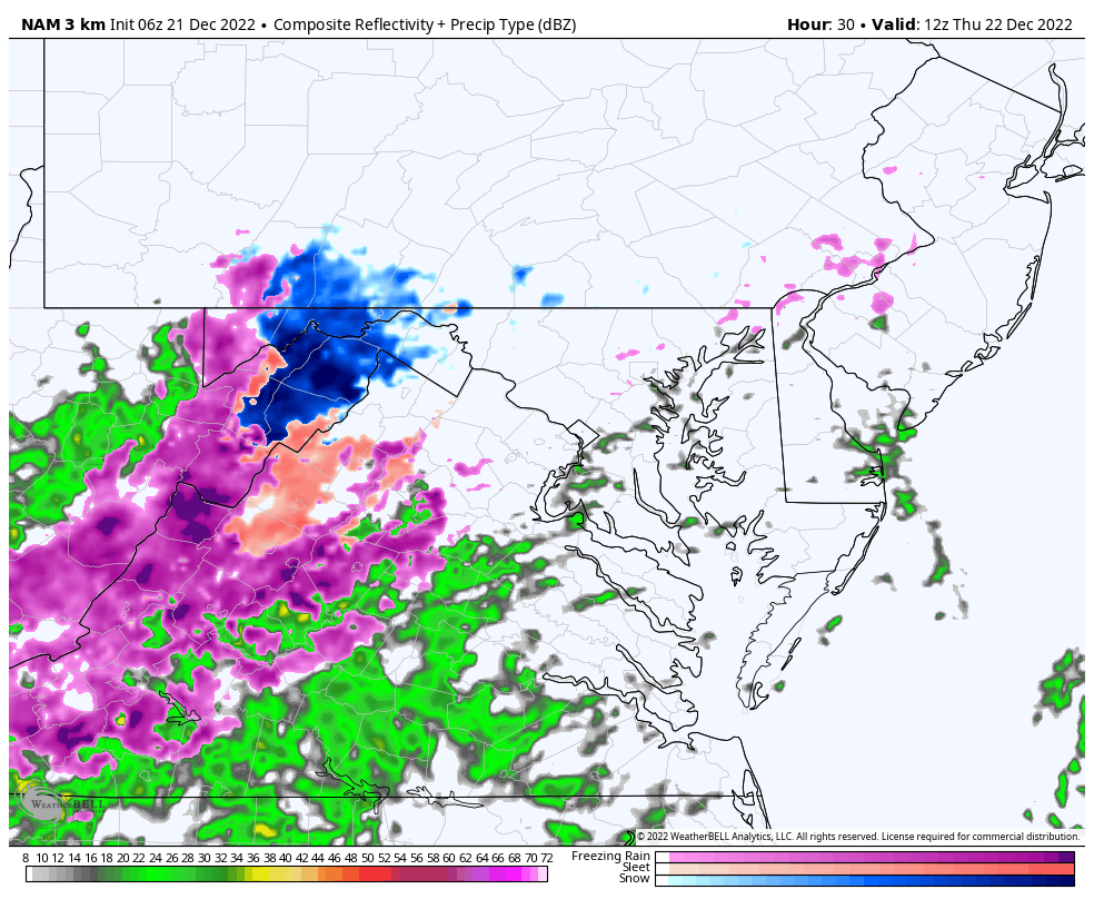
Radar Simulation Thursday 7 AM to 7 PM
This is the NAM 3 Km model, which is a higher resolution. It did the best job with our ice/rain last week.
Notice the initial snow (blue) and icy mix (pink) at the start, eventually giving way to heavier rain during the day and evening.
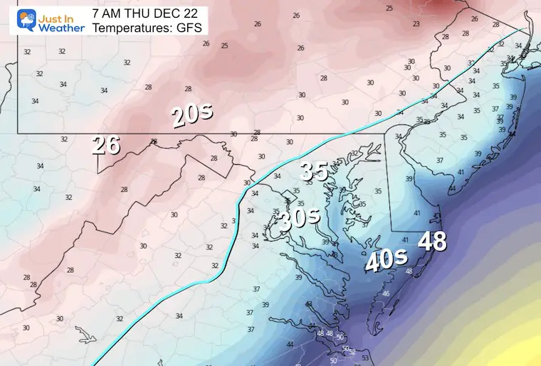
7 AM Temperatures
I’ve noticed the most likely freezing line. Reminder that the ground is colder than last week, so there is a better chance to support frozen precipitation.
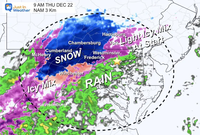
9 AM Radar Simulation
This snapshot is when the ‘stuff’ is likely to be happening. It could develop between 7 AM and 10 AM.
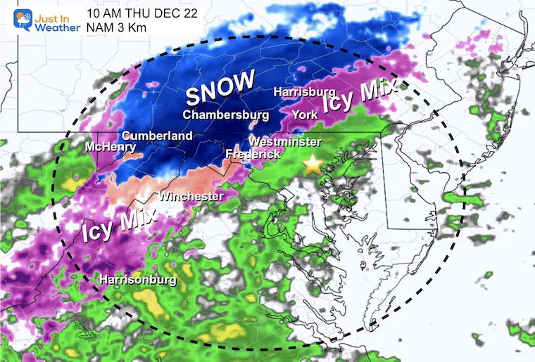
10 AM Radar Simulation
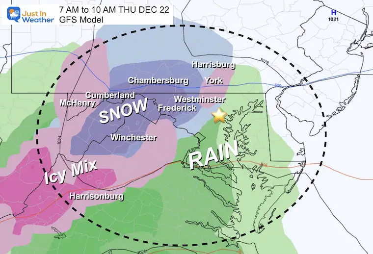
The edge of potential mix is between Frederick, Westminster, and York.
West is the travel concern where there is an Advisory or a Warning. Closer to the cities should be rain.
GFS Model BETWEEN 7 AM and 10 AM
We see agreement with the leading edge of a mix. If this arrives before 8 AM, then it might be an issue on the eastern Edge. More likely problems farther west.
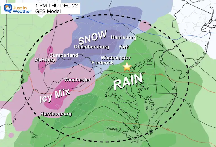
GFS Model 1 PM
Icy travel remains inland around I-81, but the thaw will expand.
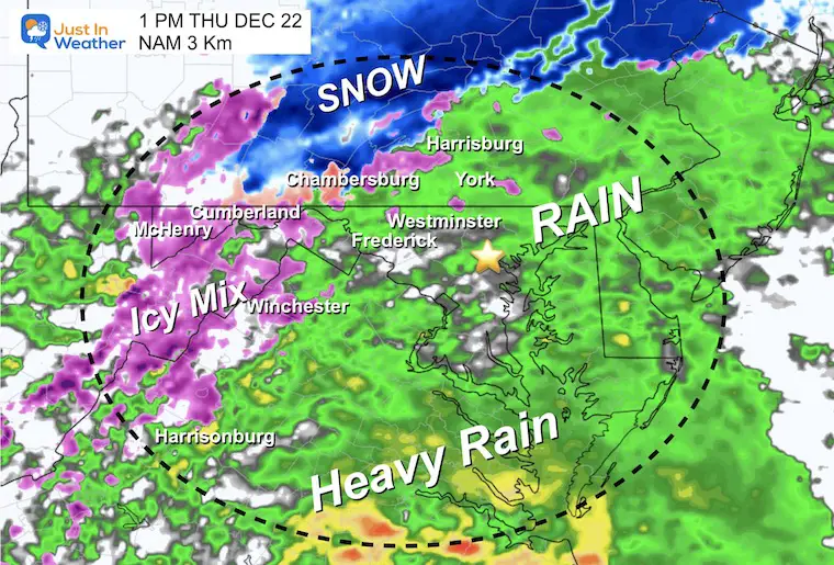
NAM Model 1 PM
This is the same time frame, just showing for model comparison and agreement.
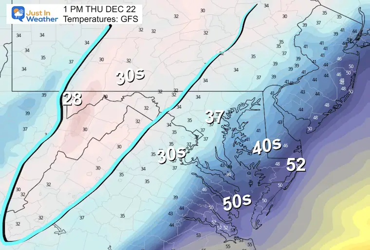
Temperatures At 1 PM
Remaining near or below freezing around and west of I-81.
Let’s Jump Ahead To Friday….
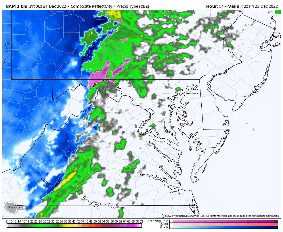
Radar Simulation NAM 3 Km
7 AM to 1 PM
Notice the quick transition from rain (green) to snow and lasting for a couple of hours. This will be enough for at least a coating to 1 inch, plus help to freeze anything on the ground that is wet.
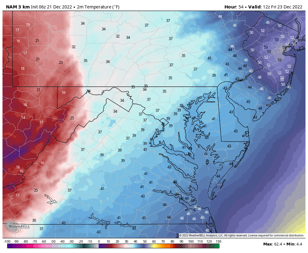
Temperature Animation
7 AM to 1 PM
Starting in the upper 30s to near 40ºF in metro areas. This is cooler than earlier model runs. That is important with the speed of the storm limiting the warming air (and ground).
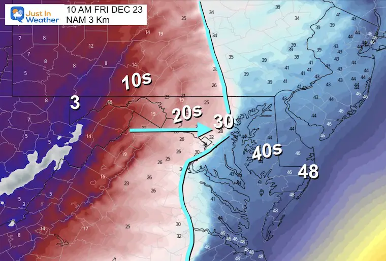
10 AM Flash Freeze Close To Baltimore
The timing is still subject to a 1-hour buffer, earlier or later. But the trend is earlier. It may take up 1 to 2 hours for the wet pavement to ice over after the drop below 32ºF.
1 PM Flash Freeze Close To Baltimore
Freezing temperatures reaching the coast.
Baltimore drops to the lower 20s with colder air to the west still flowing in!

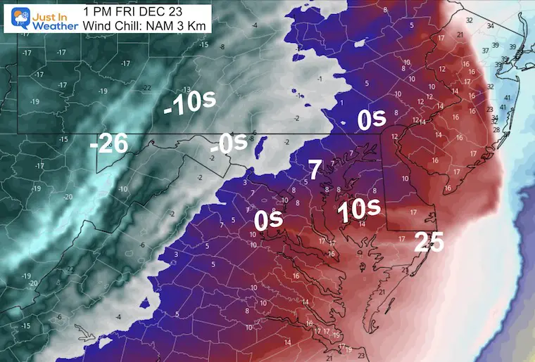
Wind Chill
It will FEEL like the single digits to Below Zero!
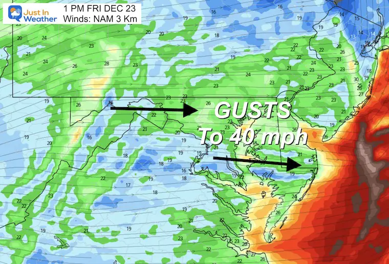
Wind Forecast
The winds will be 20 to 30 mph with gusts to 40 mph as the arctic air arrives and continues the rest of the day.
I will have more details on this part of the storm and weekend in my next report tonight.
In Case You Missed It:
In my prior report I answered two common questions about this event. Both will be validated over the next few days.
What is a Bomb Cyclone?
In short, a storm is low pressure, and a deeper storm has lower numbers of atmospheric pressure we measure in millibars (mb). When a storm gets stronger, the mb are lower numbers, which we say are ‘dropping’.
A Bomb Cyclone is defined as a storm dropping more than 24 mb in 24 hours, or more than 1 mb per hour for a day. See my report here for the maps that prove this.
What is a Flash Freeze?
This is when arctic air arrives and turns wet pavements to ice. We expect temperatures to drop midday Friday. The challenge is if the pavements will remain wet as the temps drop, to allow ice to form on roads. Or will the cold wind evaporate that wet pavement, drying up before it has a chance to freeze.
Faith in the Flakes Gear

What is Faith in the Flakes?
It began with my son in 2009
October 27 Nor’easter Recap Still Breezy Then Next Storm Friday
SNOWSTIX – Available Now

STEM Assemblies/In School Fields Trips Are Back
Click to see more and ‘Book’ a visit to your school

My Winter Outlook: Not A Typical La Niña!
I see many factors to support colder influence with multiple systems. Early and later in winter. Check it out.
October 27 Nor’easter Recap Still Breezy Then Next Storm Friday
Also See The Winter Outlook Series:
October 27 Nor’easter Recap Still Breezy Then Next Storm Friday
Winter Outlook 2023 La Niña Triple Dip Expectations
Farmer’s Almanac Comparison
September Starts Meteorological Autumn: Weather Climate Stats For Maryland at Baltimore
Triple Dip La Niña Winter
Winter Outlook 2023 La Niña Triple Dip Expectations
CONNECTION TO WINTER?
If you want a snowy winter, this is what you might want to look for in the rest of the tropical season. (You might be seeing a lot of commercial snow removal people out this Winter).
Rainbow Ice Cave In Mt. Rainier A Very Rare Find: Photos And Video
Wooly Bear Caterpillars
https://justinweather.com/2022/10/25/winter-weather-outlook-from-the-wooly-bear-caterpillar/
Persimmon Seeds
Winter Weather Outlook: Persimmon Seeds And Snow Folklore
Click to see Top 20 and MORE
Winter Weather Folklore Top 20 And More Outlook Signals From Nature For Cold And Snow
Normals And Records: Maryland and Baltimore Climate History

Please share your thoughts, best weather pics/videos, or just keep in touch via social media


