La Niña Likely To End During This Winter Increasing Late Season Snow Odds
Friday December 9 2022
The NOAA Climate Prediction Center based in College Park Maryland just updated their expectations for the current La Niña and it confirms what I shared in my winter outlook. While we are currently in a La Niña Advisory and in a rare Triple Dip La Niña starting winter, there is a very good chance it will end during the winter. The impact supports a greater chance for classic winter weather, meaning more storms with snow.
The La Niña phenomenon is essentially cooler than average water in the equatorial part of the central Pacific Ocean. The impacts affect weather patterns around the globe, including winter storm tracks in North America.
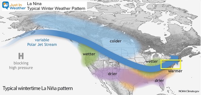
Typical La Niña Winter Weather Pattern
If you love snow in the Mid Atlantic, this has not been favorable. Historically, La Niña has led to warmer winters with less snow. However, there have been exceptions or even winters with one big snow storm, while otherwise mild.
But with La Niña possibly ending, we remove that hinderance and our snow chances will increase. Given all of the other patterns that are encouraging for cold and snow for the eastern US, the support is tipping more in that favor.
Also see my La Niña page for more climate data on the historical local impacts.
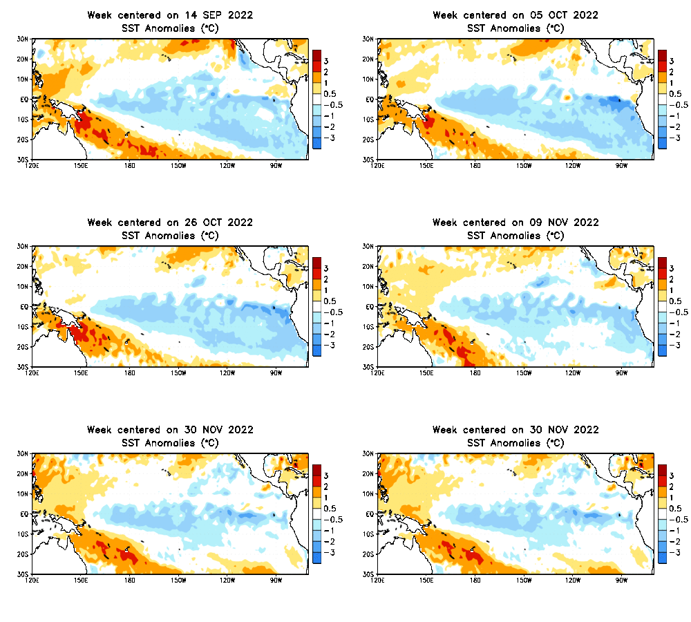
Sea Surface Temperature Anomalies
- Location: Tropical Pacific Ocean
- Time: September 14 to November 30, 2022
- Blue = colder than average
- Orange = warmer than average
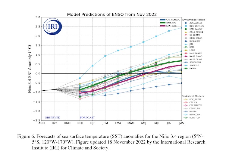
NOAA Report:
“La Niña will persist into the Northern Hemisphere winter 2022-23. For the dynamical model averages, ENSO-neutral is favored in January-March 2023, while the statistical model average shows the transition to ENSO-neutral occurs in February-April 2023”
See the full official NOAA report here.
CHART
Columbia Climate School Model Forecast
ENSO (El Niño/Southern Oscillation)
The consensus including The North American Multi-Model Ensemble is broken down like this:
January through March: Even chances for La Nina to continue or trend neutral. This means water temperatures in the equatorial region of the Pacific Ocean will warm to neutral or near average.
February through April: There is a 71% chance of the water temperatures back to ‘near normal’.
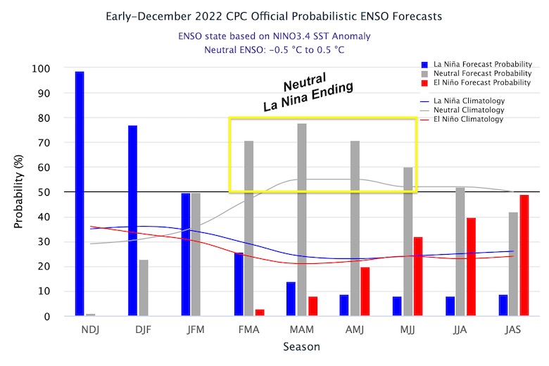
ODDS OF CONDITIONS IN 3-MONTH PERIOD
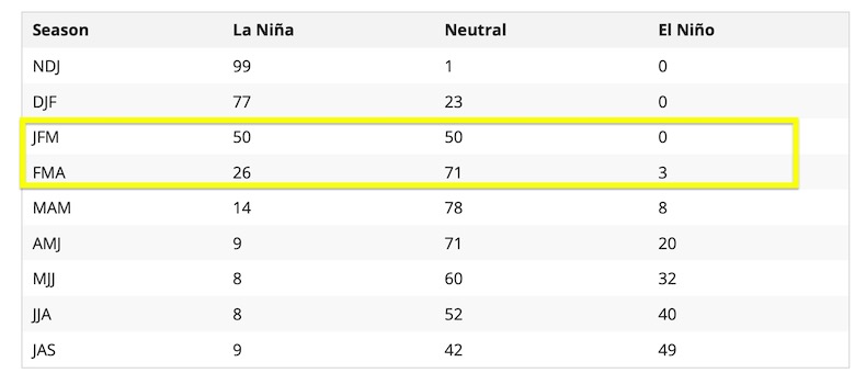
These are the numbers that correspond to the chart above.
JFM = January, February, and March. This period is 50% to remain La Niña or transition to neutral.
FMA = February, March, and April. This is the period with the 71% of trending to neutral.
What does this mean?
A Typical La Niña (not all) would produce a storm track that runs inland across the eastern US, bringing in warmer air, such as shown above.
As I discussed in my Winter Outlook, there are many other factors that influence our storm tracks. The early winter should focus on the North Atlantic Oscillation and Polar Vortex disruption. Both appear to be on track to show a colder trend for us mid December (next week). Later in winter, a relaxed La Niña would favor all the forces that can drive colder and more stormy weather for the Mid Atlantic and Eastern US.
If you have Faith in the Flakes, this is the news you want to hear. Let the games begin!
FITF
October 27 Nor’easter Recap Still Breezy Then Next Storm Friday
Also See The Winter Outlook Series:
October 27 Nor’easter Recap Still Breezy Then Next Storm Friday
Farmer’s Almanac Comparison
September Starts Meteorological Autumn: Weather Climate Stats For Maryland at Baltimore
Triple Dip La Niña Winter
CONNECTION TO WINTER?
If you want a snowy winter, this is what you might want to look for in the rest of the tropical season. (You might be seeing a lot of commercial snow removal people out this Winter).
Rainbow Ice Cave In Mt. Rainier A Very Rare Find: Photos And Video
Wooly Bear Caterpillars
https://justinweather.com/2022/10/25/winter-weather-outlook-from-the-wooly-bear-caterpillar/
Persimmon Seeds
Click to see Top 20 and MORE
Winter Weather Folklore Top 20 And More Outlook Signals From Nature For Cold And Snow
Faith in the Flakes Gear
SNOWSTIX – Available Now
Normals And Records: Maryland and Baltimore Climate History
STEM Assemblies/In School Fields Trips Are Back
Click to see more and ‘Book’ a visit to your school
Please share your thoughts, best weather pics/videos, or just keep in touch via social media
-
Facebook: Justin Berk, Meteorologist
-
Twitter: @JustinWeather
-
Instagram: justinweather


