Tropical Storm Earl and Hurricane Danielle Update September 4
Sunday Morning Update
September 4 2022
Two named storms in the Atlantic Ocean may look busy, but this is the climate supported busiest time of the year. The peak is 10 days away, but the 5 days outlook shows these are the only two players.
With Hurricane Danielle in the North Central Atlantic, this remains over water and may be more of an impact for Europe. So we will start with Tropical Storm Earl, which is showing signs up intensifying. This is close to the Virgin Islands and Puerto Rico, but the forecast keeps it offshore.
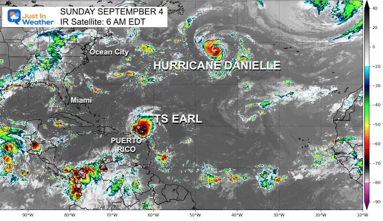
Tropical Storm Earl
IR Satellite Close Up
Top winds are 50 mph, with tropical storm force winds extend 105 miles from the center.
NOT a direct hit, but there will be some impact with wind and rain, plus higher surf on the north shore of the islands.
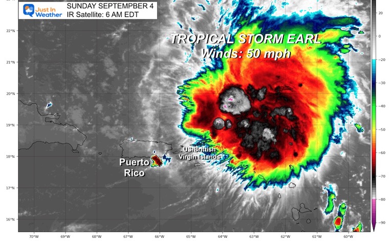
National Hurricane Center
Sunday Morning Update
SUMMARY OF 500 AM AST...0900 UTC...INFORMATION
----------------------------------------------
LOCATION...19.5N 64.9W
ABOUT 75 MI...125 KM N OF ST. THOMAS
MAXIMUM SUSTAINED WINDS...50 MPH...85 KM/H
PRESENT MOVEMENT...WNW OR 285 DEGREES AT 8 MPH...13 KM/H
MINIMUM CENTRAL PRESSURE...999 MB...29.50 INCHES
Forecast Intensity
This should remain a strong tropical storm into early next week. The forecast to reach hurricane intensity on Day 4 or Day 5, which would be by Thursday.
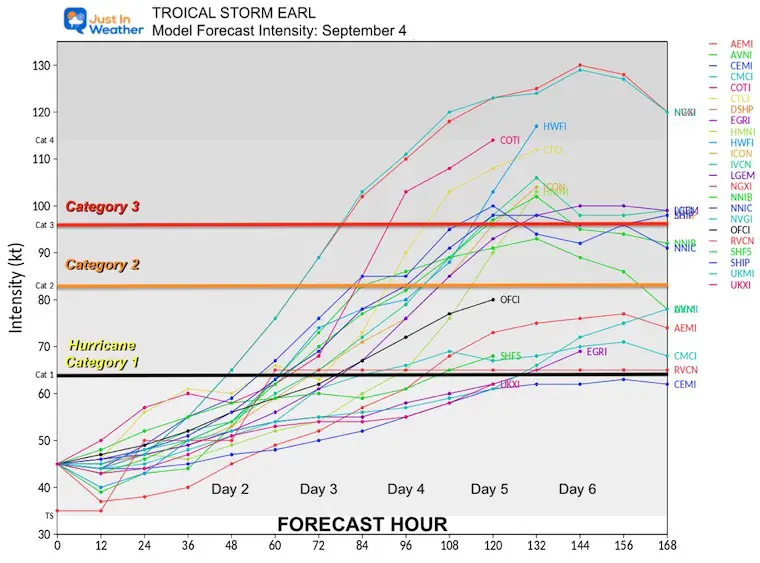
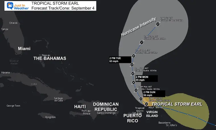
TS Earl Forecast Tracks
This is expected to pass NORTH of Puerto Rico, but waves will be felt on the north side including the Virgin Islands as well.
Rainfall: Expected 2 to 4 inches cross the Virgin Islands and Puerto Rico. Some spots up to 6 inches.
Weather Widget
Controls in the upper right:Check the view size and location. Also Toggle between Radar and Wind
Hurricane Danielle
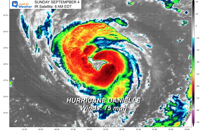
National Hurricane Center
Sunday Morning Update
SUMMARY OF 500 AM AST...0900 UTC...INFORMATION
----------------------------------------------
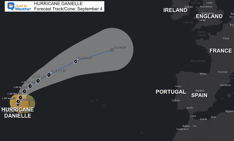
LOCATION...38.1N 45.2W
ABOUT 990 MI...1590 KM W OF THE AZORES
MAXIMUM SUSTAINED WINDS...75 MPH...120 KM/H
PRESENT MOVEMENT...N OR 360 DEGREES AT 1 MPH...2 KM/H
MINIMUM CENTRAL PRESSURE...988 MB...29.18 INCHES
Hurricane Danielle Forecast Tracks
This storm may spin itself out before reaching Europe. However, there will be high waves on the western shores and eventually a rain storm perhaps next weekend.
REMINDER
Comparing Record Years:
Augusts With No Named Tropical Storms
- 1961
- 1997
- 2022
The other two years BOTH had a named storms within the first few days of September.
Both of them reached Major Hurricane Intensity (Category 3 or higher)
1961- Tropical Season
Prior To August: This year started very quiet and only had 1 named storm (Anna).
From September on:
September 2 was the next name and it got busy in a hurry! The second named storm was Betsy – This reached Category 4, but remained in the open ocean not making landfall.
1997- Tropical Season
Prior to August: This was a busier year with 4 Named Storms, one subtropical storm and one tropical depression.
From September on:
September 3 was another quick return when Erika was named. This also became a Major Hurricane, reaching Category 3.
EXPLORE MORE
See how the rest of the season compared to the following winter snowfall. There was a distinct difference.
Rainbow Ice Cave In Mt. Rainier A Very Rare Find: Photos And Video
Hurricane Season Forecast: June 1 Through November 30
NOAA 2022 Hurricane Forecast- Above Normal Again
Forecast From Colorado State University
Related Posts
NOAA Study: Reducing Air Pollution INCREASED Tropical Storms
Atlantic Tropical History: Maps of Origin Regions Every 10 Days
STEM Assemblies/In School Fields Trips Are Back
Click to see more and ‘Book’ a visit to your school
ALSO SEE
September Begins Meteorological Autumn
Climate Data/Weather Stats For The Month
Rainbow Ice Cave In Mt Rainier
Rainbow Ice Cave In Mt. Rainier A Very Rare Find: Photos And Video
Please share your thoughts, best weather pics/videos, or just keep in touch via social media
-
Facebook: Justin Berk, Meteorologist
-
Twitter: @JustinWeather
-
Instagram: justinweather


