August 31 TS Idalia Moving Off The Coast: Storm Videos Plus Cool Then Hot Labor Day Weekend
August 31, 2023
Thursday Morning Update
Idalia has left a trail of destruction across the Southeast US and is still affecting the Carolinas up to Virginia and even Ocean City Maryland. Clouds did spread into the Mid Atlantic, but the rain has been suppressed thanks to High Pressure moving in to control the week ahead with dry weather. That may make for a great holiday weekend but expand the drought conditions.
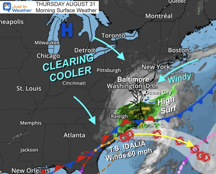
Morning Surface Weather
This is the closest approach of Idalia to our region. It has produced a veil of clouds, which will move away as we clear out today.
Inland turns sunny, but the beaches will remain breezy with gusts of 25 to 30 mph. Waves may also remain high into the weekend.
Closer Look Below Includes The Climate Data AND our local forecast.
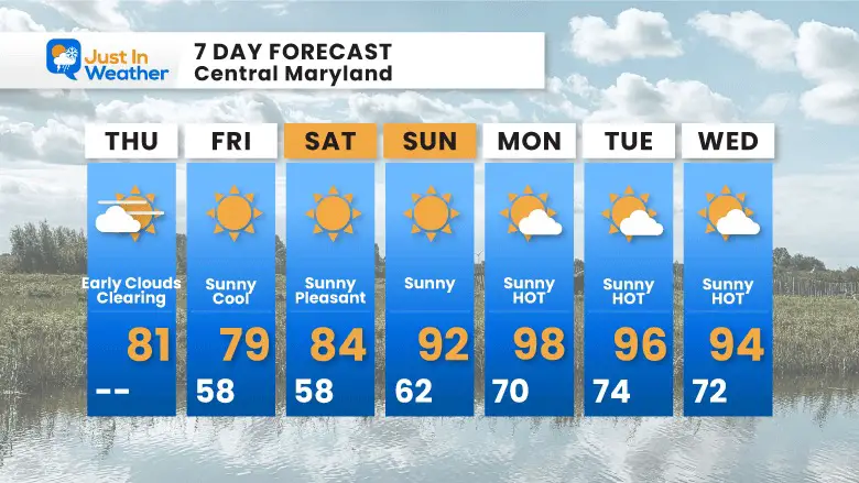
A large swing from chilly to very hot weather is expected over the next five days.
But first, I want to show the latest on Idalia and a few videos from the path of destruction, including a tornado flipping a car in Charleston, SC.
Idalia Videos
Tornado Flipping A Car in Charleston, SC
Surge Slamming Boats Into Bridge
Destruction from Horseshoe Beach, FL
This is closest to the landfall
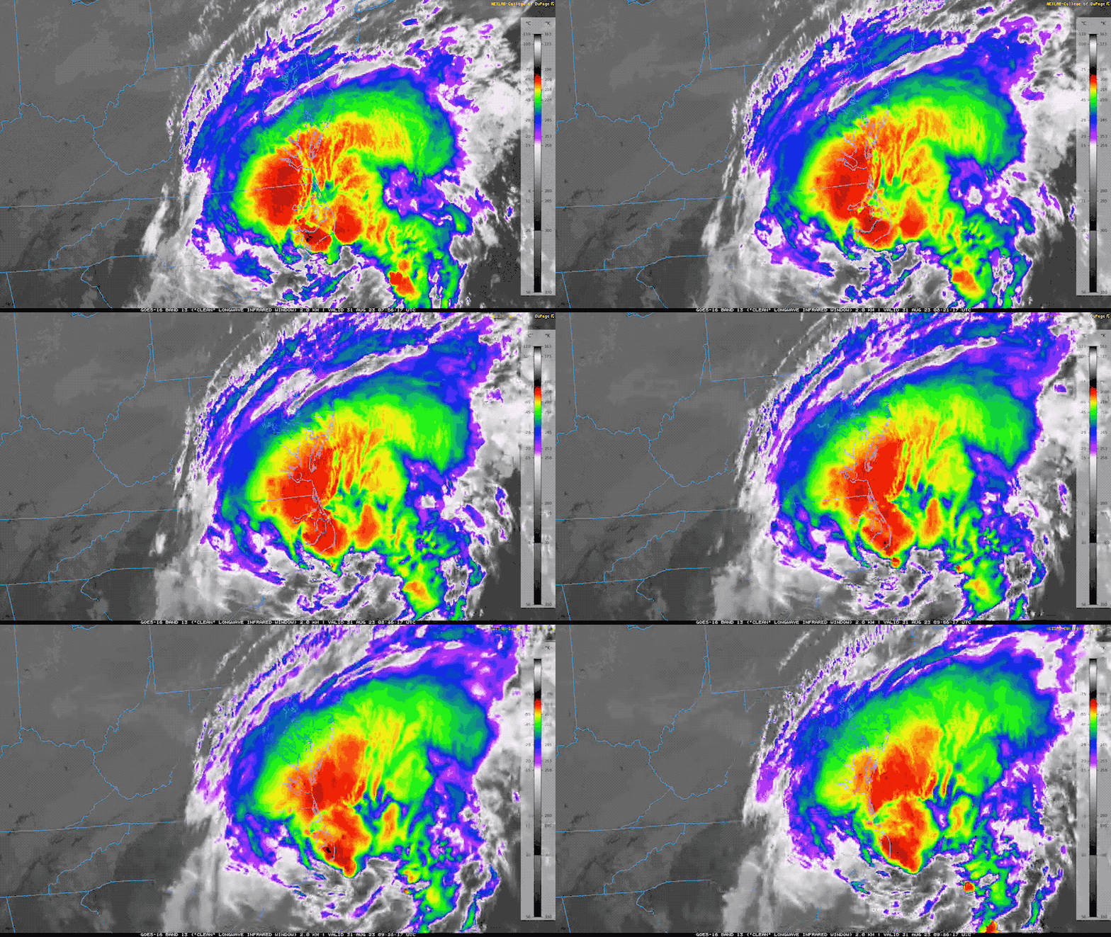
Tropical Storm Idalia Satellite Loop
Max Winds Now 60 mph
Tropical Storm Force Winds reach 185 miles from the center.
Tropical Storm Idalia
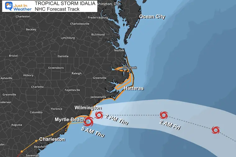
National Hurricane Center Update
- LOCATION…33.6N 78.0W
- ABOUT 45 MI…70 KM SSW OF WILMINGTON NORTH CAROLINA
- MAXIMUM SUSTAINED WINDS…60 MPH…95 KM/H
- PRESENT MOVEMENT…ENE OR 75 DEGREES AT 21 MPH…33 KM/H
- MINIMUM CENTRAL PRESSURE…991 MB…29.27 INCHES
National Hurricane Center Forecast Track/Times
Tropical Storm Idalia continues to move off the coast. At this time, it is expected to remain a tropical storm for the next 5 days. See the model forecast below for the long-range suggestion that it may loop back.
WATCHES AND WARNINGS
- A Tropical Storm Warning is in effect for…
- South Santee River northward to the North Carolina/Virginia border
- Pamlico and Albemarle Sounds
- A Storm Surge Watch is in effect for…
- Beaufort Inlet to Ocracoke Inlet, North Carolina
- Neuse and Pamlico Rivers, North Carolina
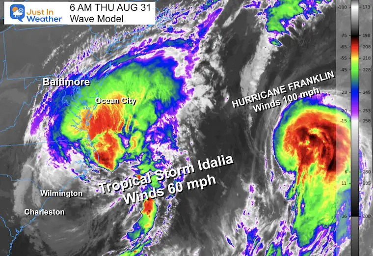
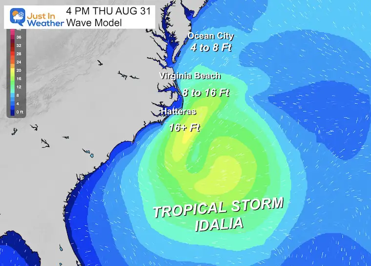
Wave Forecast This Afternoon
The wave heights will reach 4 to 8 feet off Ocean City.
Those heights may be double across Cape Hatteras and the Outer Banks of North Carolina.
LOCAL WEATHER
Live Interactive Radar (see the forecast below)
CLIMATE DATA: Baltimore
TODAY August 31
Sunrise at 6:34 AM
Sunset at 7:39 PM
Normal Low in Baltimore: 65F
Record 49ºF in 1986
Normal High in Baltimore: 85ºF
Record 102ºF 1953
Subscribe for eMail Alerts
Weather posts straight to your inbox
Sign up and be the first to know!
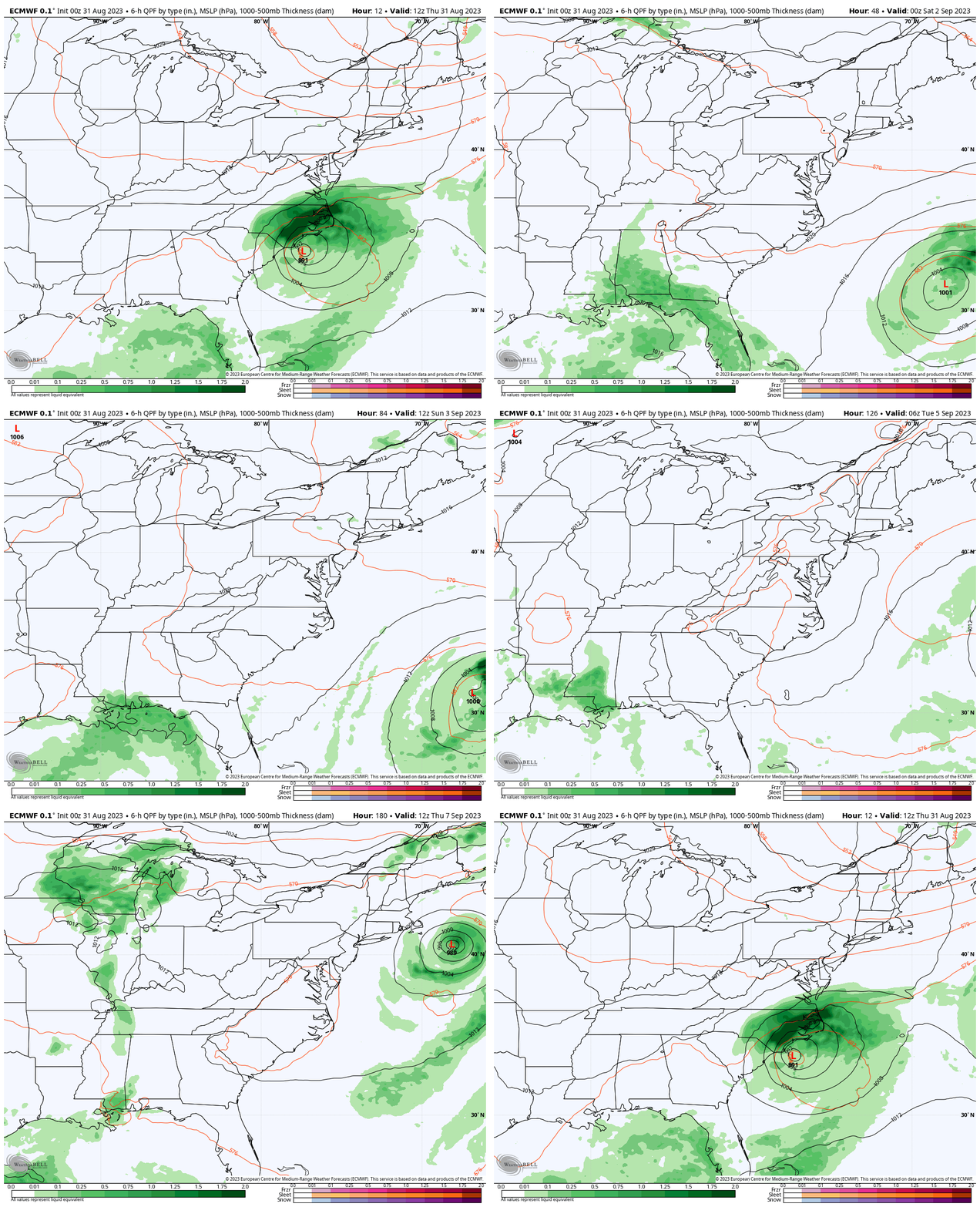
ECMWF Model Forecast
Thursday Morning to NEXT Friday Morning
Watch Tropical Storm Idalia move off the coast, and a long trend of dry weather builds in… along with heat! Later in the period, Idalia may loop back towards the US coast.
I need to caution the effort here. Yesterday, the suggestion was for it to loop back towards Florida, but here we see New England. I would hold off on any confirmation yet.
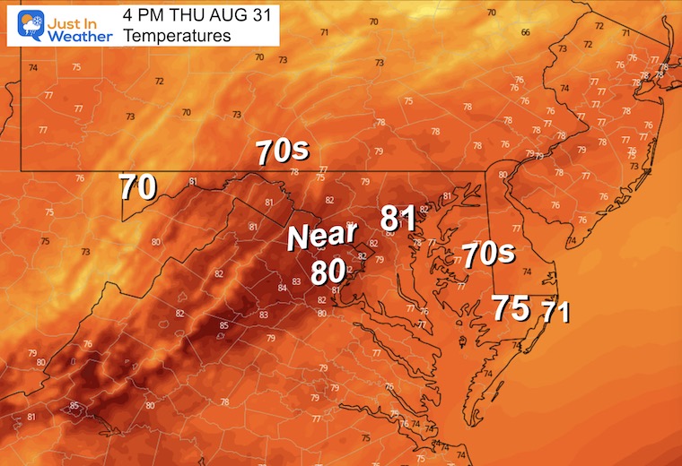
Temperature Forecast
Thursday Afternoon
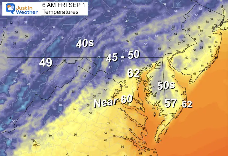
Friday Morning
This will be the first of two chilly mornings.
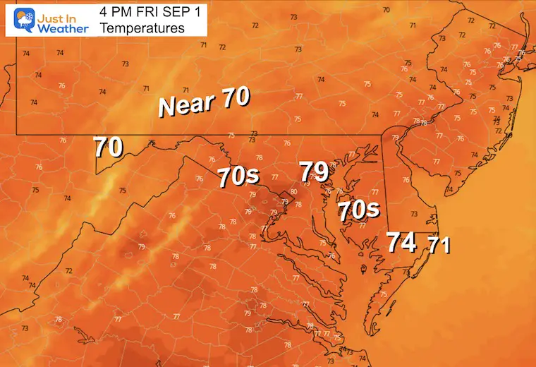
Friday Afternoon
Enjoy the pleasant cool day, it will heat up in a hurry over the weekend.
7 Day Forecast
As Idalia moves off the coast, it will initially bring in cooler weather, then be followed by a taste of that Heat Dome. We will get into the 90s over the Labor Day Weekend and into next week while remaining sunny and dry.
EXPLORE MORE
2023 Hurricane Season Forecast With An El Niño Watch
EARLIER THIS MONTH: Maryland Trek 10 For These Kids
I will have a follow-up and recap on our amazing week shortly.
Subscribe for eMail Alerts
Weather posts straight to your inbox
Sign up and be the first to know!
La Niña Has Ended. El Niño May Return By Fall
Aurora Photos From Maryland, Delaware, and Virginia
Please share your thoughts and best weather pics/videos, or just keep in touch via social media
-
Facebook: Justin Berk, Meteorologist
-
Twitter
-
Instagram
RESTATING MY MESSAGE ABOUT DYSLEXIA
I am aware there are some spelling and grammar typos and occasional other glitches. I take responsibility for my mistakes and even the computer glitches I may miss. I have made a few public statements over the years, but if you are new here, you may have missed it: I have dyslexia and found out during my second year at Cornell University. It didn’t stop me from getting my meteorology degree and being the first to get the AMS CBM in the Baltimore/Washington region. One of my professors told me that I had made it that far without knowing and to not let it be a crutch going forward. That was Mark Wysocki, and he was absolutely correct! I do miss my mistakes in my own proofreading. The autocorrect spell check on my computer sometimes does an injustice to make it worse. I also can make mistakes in forecasting. No one is perfect at predicting the future. All of the maps and information are accurate. The ‘wordy’ stuff can get sticky. There has been no editor who can check my work when I need it and have it ready to send out in a newsworthy timeline. Barbara Werner is a member of the web team that helps me maintain this site. She has taken it upon herself to edit typos when she is available. That could be AFTER you read this. I accept this and perhaps proves what you read is really from me… It’s part of my charm.
#FITF


