August 25, 2023
Friday Morning Update
Thunderstorms have dropped in overnight from Pennsylvania. This cluster may have awakened some of you with loud boomers, but it is falling apart in Maryland. More on the way.
Today will be warm and humid, but not extreme as this will be a focus for instability producing more clouds and storms today.
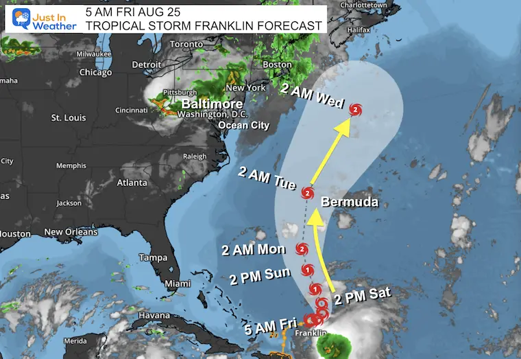
Tropical Storm Franklin is still likely to be a Hurricane and may reach Category 2 when passing close to Bermuda. It will influence the next weather system to stall over us early next week for a day of needed rain as more cool weather arrives.
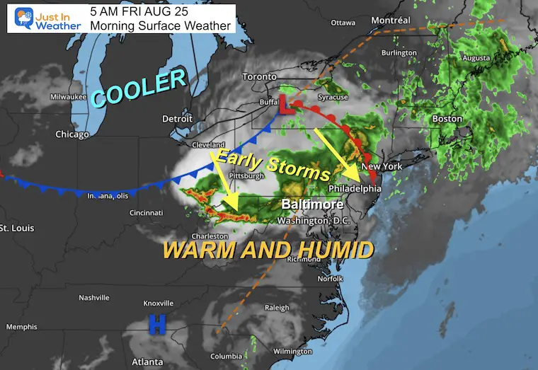
Morning Surface Weather
A frontal boundary is associated with the cluster of storms that are passing through Pennsylvania and northern Maryland. This complex has produced lightning and thunder with heavy rain overnight. It will bring showers into Maryland while it falls apart.
This track of rain will continue as a focus today for more, and hold the heat dome just west and south. So we will NOT get into the true heat.
Live Radar Widget
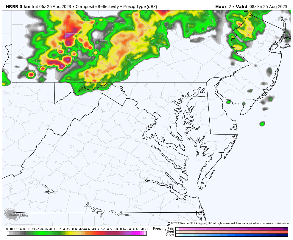
The storm cluster that hit PA and Ohio overnight reached Maryland before sunrise AND is expected to fall apart.
There will be more showers off and on throughout the day.
Use the controls to zoom/pan the map, and play the animation.
Radar Simulation
4 AM to 8 PM
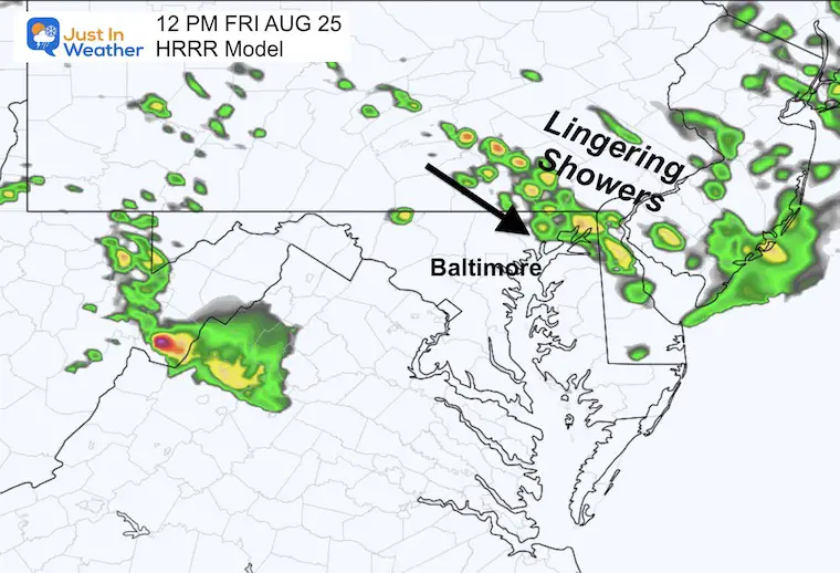
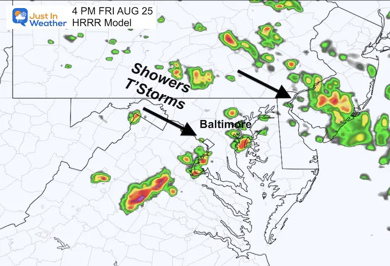
I backed this up to show the storm cluster in PA as it has been projected to fall apart across Maryland. However, more showers will linger mid-day and redevelop in the late afternoon and evening.
Radar Snapshots
This product is NOT perfect and we may see more action than suggested here.
Noon – Focus across Northeastern Maryland
4 PM – Scattered storms will redevelop
8 PM – Focus on Central Maryland South of Baltimore may include Annapolis

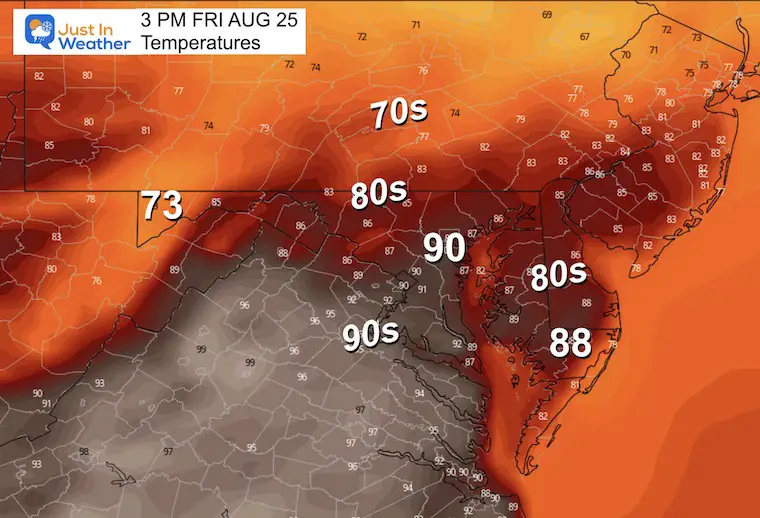
Afternoon Temperatures
It will be warm and humid. Any sunny breaks will boost the temps closer to 90ºF, but we will miss the heat dome thanks to the showers.
In Case You Missed It (click the image)
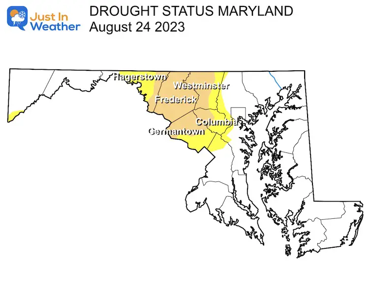
Drought Update From Aug 24 For MD, PA, and VA
CLIMATE DATA: Baltimore
TODAY August 25
Sunrise at 6:29 AM
Sunset at 7:47 PM
Normal Low in Baltimore: 65ºF
Record 51ºF in 1952 AND 1963
Normal High in Baltimore: 86ºF
Record 97ºF 1936 AND 1948 AND 1968
Subscribe for eMail Alerts
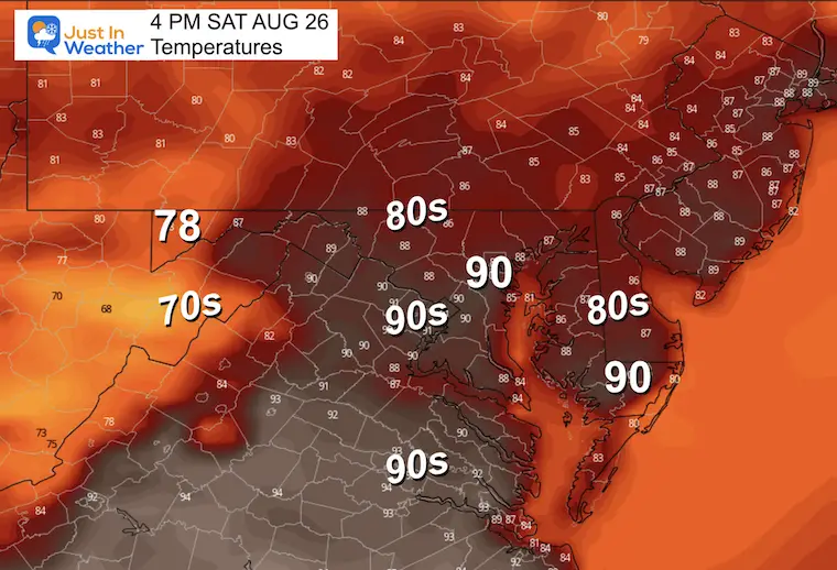
Saturday
Still holding onto some of the very warm air in a more stable environment.
Morning Temperatures

Afternoon Temperatures
Still warm and there may be an isolated shower.
Extended Forecast: Sunday to Thursday
Here we can see Franklin show up on the edge of the map as it moves north and becomes a Hurricane.
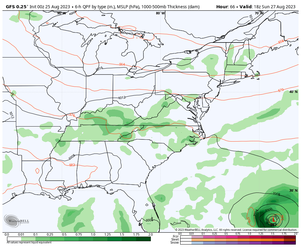
It will curve away from the US and be close to Bermuda. The next cold front will stall along the eastern US on Monday. There will be a period of rain while waiting for Franklin to pass by.
Tropical Storm Franklin
Located in the Atlantic North of the Dominican Republic. Winds are up to 60 mph and it will make a turn north and strengthen into a hurricane. It is forecast to miss the United States early next week but will send high waves to the East Coast. It will be closer to Bermuda.
Morning Snapshot and National Hurricane Center Stats
Update at 5 AM EDT Thu Aug 25
- LOCATION…22.7N 68.0W
- ABOUT 215 MI…345 KM ENE OF GRAND TURK ISLAND
- ABOUT 690 MI…1110 KM SSW OF BERMUDA
- MAXIMUM SUSTAINED WINDS…60 MPH…95 KM/H
- PRESENT MOVEMENT…ENE OR 75 DEGREES AT 6 MPH…9 KM/H
- MINIMUM CENTRAL PRESSURE…1000 MB…29.53 INCHES
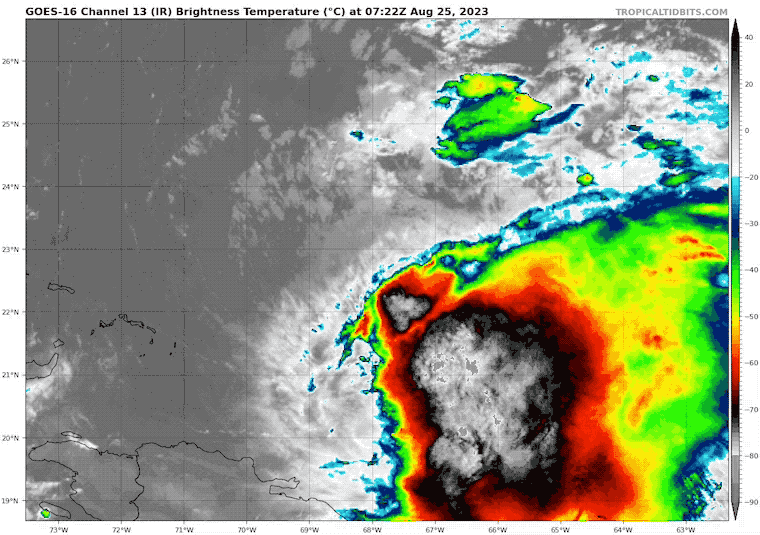
Tropical Satellite Loop
Tropical Storm Force Winds: Extend 105 miles from the center.
We can see the influence of wind sheer FROM the west blowing the top of the clouds away from the center. This is what is limiting growth for now. That is expected to diminish as this turns north, allowing it to strengthen to a hurricane over the weekend.
Forecast Track and Advisories From The National Hurricane Center
EXPLORE MORE
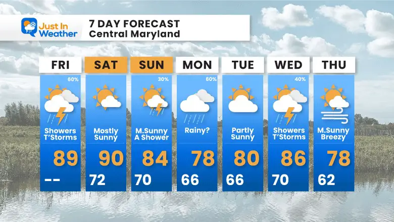
7 Day Forecast
We miss the main heat dome and get back to cooler weather by the end of the weekend.
While Franklin passes west of Bermuda as a Hurricane, it will miss the US. It will also stall a weather system over the Eastern US that will bring us rain on Monday.
EARLIER THIS MONTH: Maryland Trek 10 For These Kids
We have raised OVER $120,000 for Just In Power Kids. THANK YOU!
I will have a follow-up and recap on our amazing week shortly.

Subscribe for eMail Alerts
EXPLORE MORE

Please share your thoughts, and best weather pics/videos, or just keep in touch via social media
RESTATING MY MESSAGE ABOUT DYSLEXIA
I am aware there are some spelling and grammar typos and occasional other glitches. I take responsibility for my mistakes, and even the computer glitches I may miss. I have made a few public statements over the years, but if you are new here you may have missed it: I have dyslexia, and found out during my second year at Cornell University. It didn’t stop me from getting my meteorology degree and being the first to get the AMS CBM in the Baltimore/Washington region. One of my professors told me that I had made it that far without knowing, and to not let it be a crutch going forward. That was Mark Wysocki and he was absolutely correct! I do miss my mistakes in my own proofreading. The autocorrect spell check on my computer sometimes does an injustice to make it worse. I also can make mistakes in forecasting. No one is perfect at predicting the future. All of the maps and information are accurate. The ‘wordy’ stuff can get sticky. There has been no editor who can check my work when I need it and have it ready to send out in a newsworthy timeline. Barbara Werner is a member of the web team that helps me maintain this site. She has taken it upon herself to edit typos when she is available. That could be AFTER you read this. I accept this and perhaps proves what you read is really from me… It’s part of my charm.
#FITF


