August 24, 2023
Thursday Morning Update
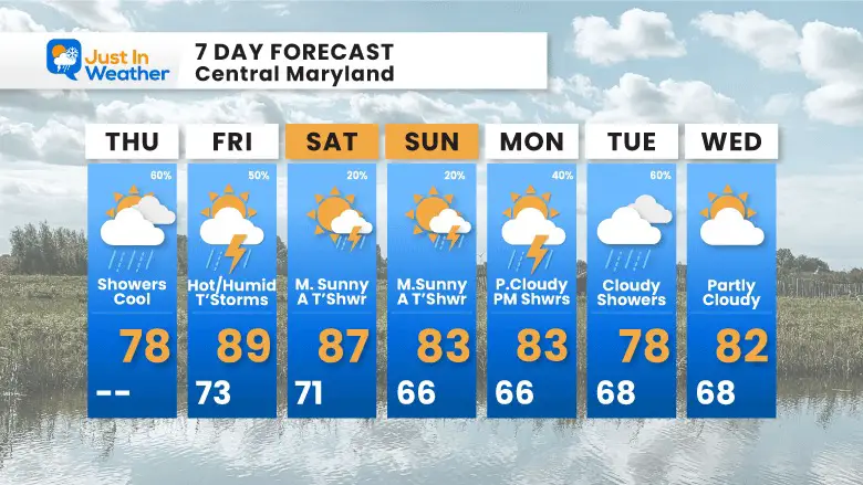
One theme I have seen all summer has been the expected heat has not verified. Once again we have one hot day on the way and it will not be that hot. First, we have rain showers this morning and more clouds that will keep today cooler.
Thunderstorms will drop in overnight and early Friday which may set us up to keep the true heat out of here. It will be hot and humid, but not extreme. Then we get back to a cooler pattern next week.
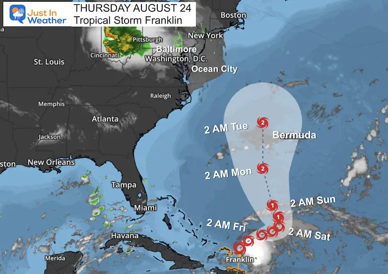
At that time Tropical Storm Franklin is likely to be a Hurricane and may reach Category 2 when passing close to Bermuda. We will miss the hit on the East Coast, but another rain event is expected to help our drought woes.
Live Radar Widget
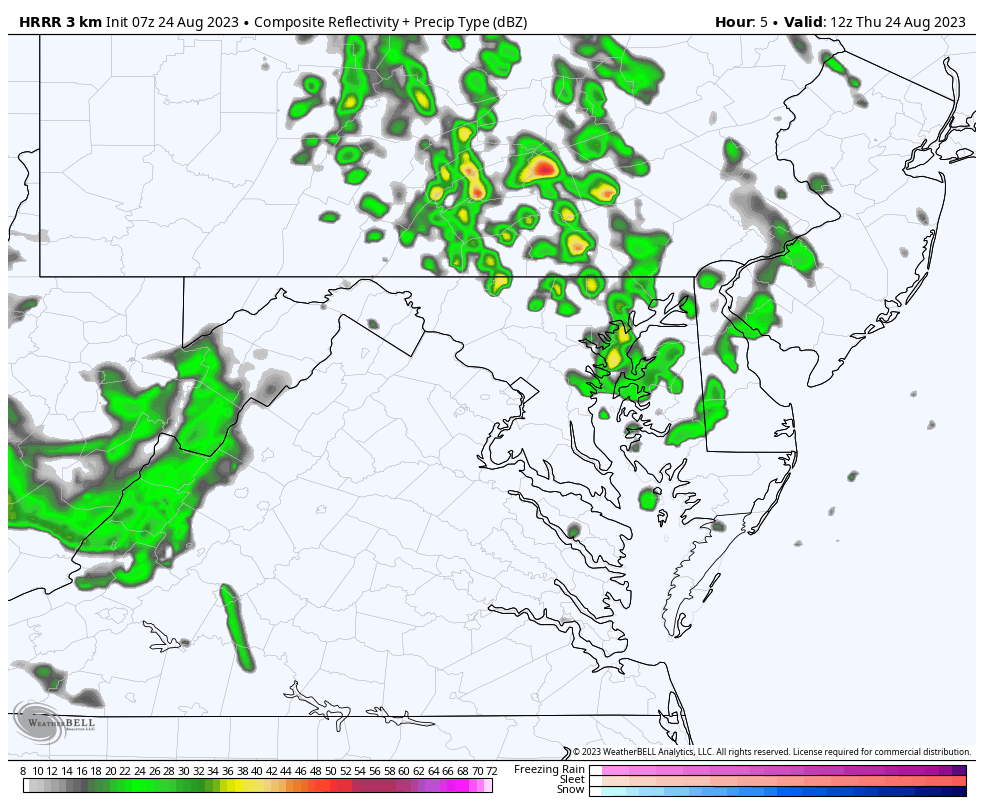
Rain showers may peak between 7 AM and 10 AM. Then we will wait for more showers and thunderstorms later in the day and overnight.
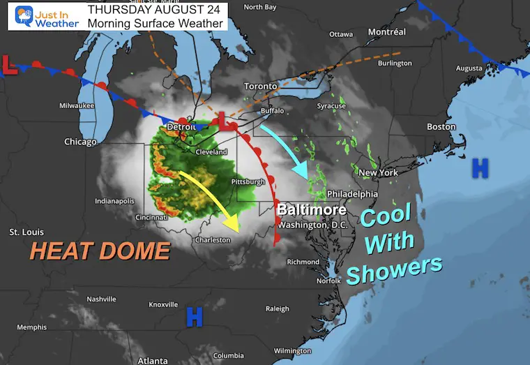
A larger cluster (MCC) of storms will pass to our west as it drops south.
Morning Surface Weather
We have a cool flow from the North which has brought in the rain this morning and more clouds today. It will remain cool.
To our west, on the EDGE of the Heat Dome is a cluster of strong thunderstorms called an MCC (Mesoscale Convective Complex). This will miss us, but after passing by we get a little nudge of that heat on Friday.
Radar Simulation
8 AM to 8 PM
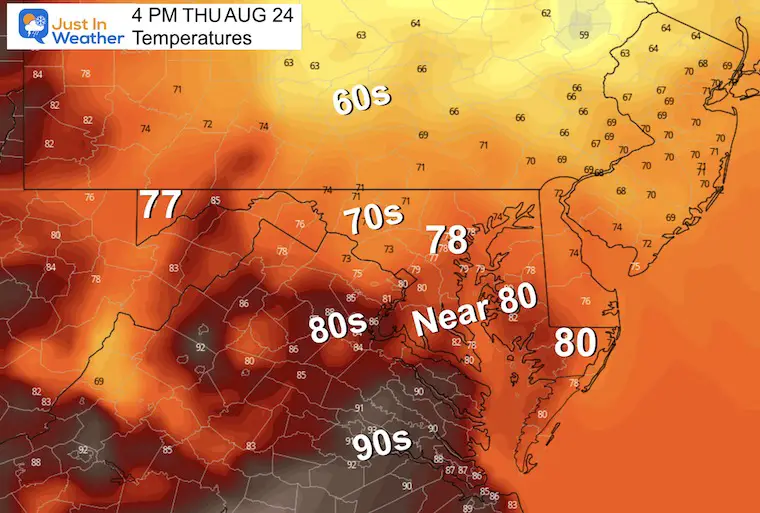
Afternoon Temperatures
Still cooler than average with added clouds, northerly winds, and scattered showers.
CLIMATE DATA: Baltimore
TODAY August 24
Sunrise at 6:28 AM
Sunset at 7:50 PM
Normal Low in Baltimore: 65F
Record 48ºF in 1952
Normal High in Baltimore: 86ºF
Record 98ºF 1968
Subscribe for eMail Alerts
Friday
Warm and humid starting with periods of showers. It will not be a washout but there will be a focus on morning showers and thunderstorms later in the day.
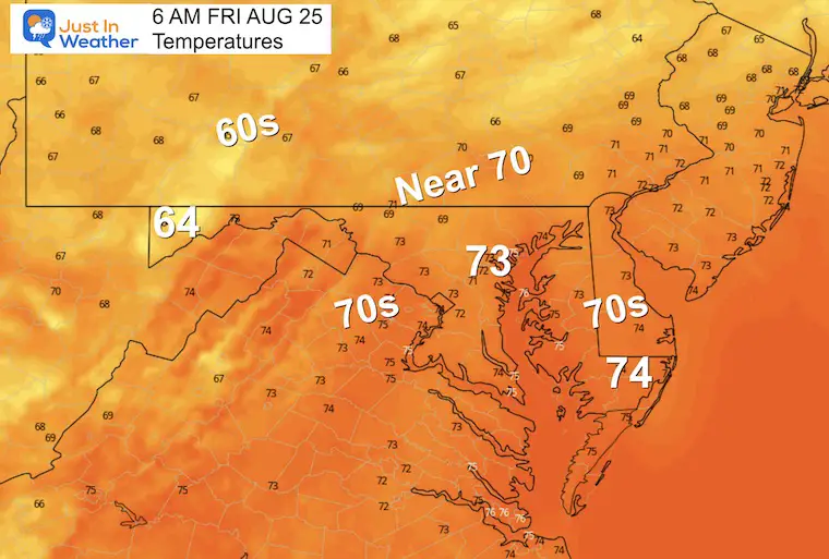
Morning Temperatures
Radar Snapshots
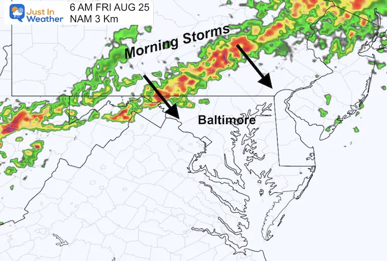
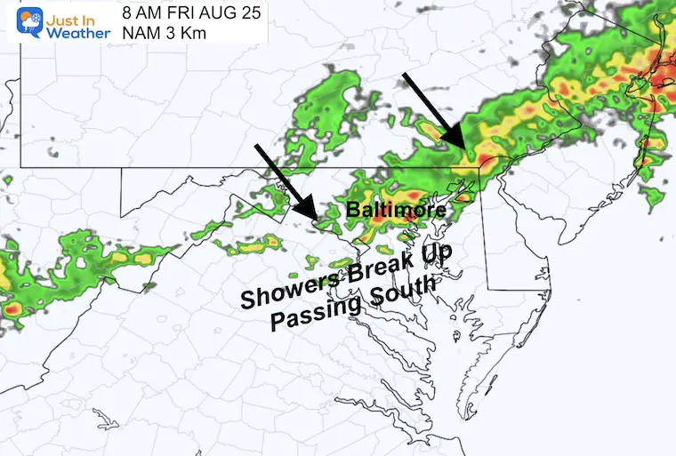
A line of thunderstorms will drop south from Pennsylvania, but break apart as it reaches central Maryland just after sunrise.
6 AM
8 AM
Radar Simulation 8 AM Friday
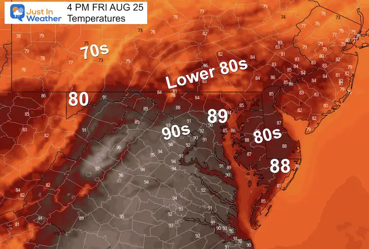
Afternoon Temperatures
The rain and clouds will limit the heat we were expecting. No extreme temperatures as many may remain in the 80s.
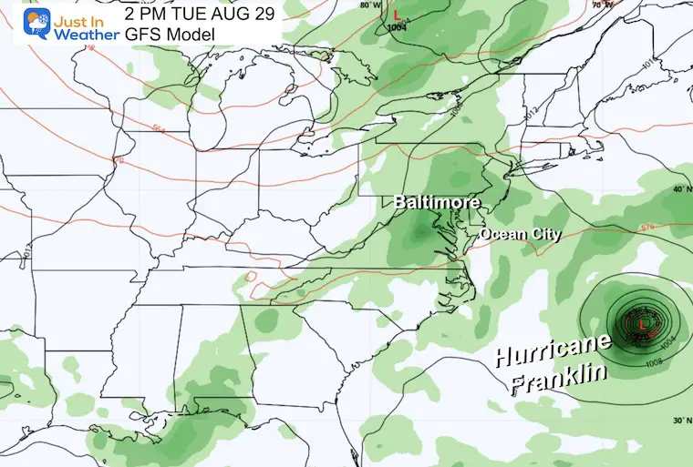
Extended Forecast: Monday Morning to Wednesday Evening
Here we can see Franklin show up on the edge of the map as it moves north and becomes a Hurricane.
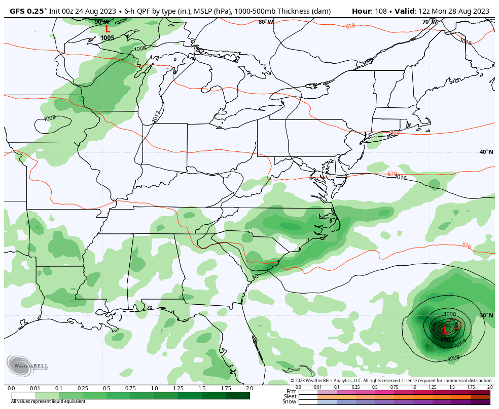
This will curve away from the US and be close to Bermuda. There will be a period of rain along the east coast that may get hung up and stall while waiting for Franklin to pass by.
Snapshot Tuesday
This should be the closest it gets to the Mid-Atlantic,
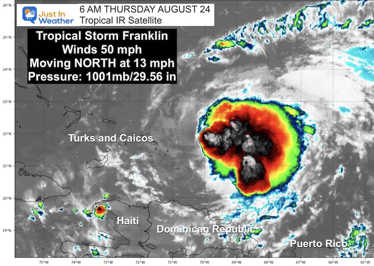
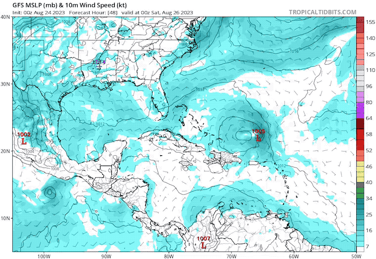
Tropical Storm Franklin
We pick up this storm as it is trying to reorganize.
It is currently in the Atlantic north of the Dominican Republic. Winds are back to 50 mph and it is going to continue to strengthen. It is forecast to miss the United States early next week, but send high waves to the East Coast. It will be closer to Bermuda.
Morning Snapshot and National Hurricane Center Stats
Update at 5 AM EDT Thu Aug 24
- LOCATION…21.9N 70.4W
- ABOUT 55 MI…85 KM ENE OF GRAND TURK ISLAND
- MAXIMUM SUSTAINED WINDS…50 MPH…85 KM/H
- PRESENT MOVEMENT…N OR 10 DEGREES AT 13 MPH…20 KM/H
- MINIMUM CENTRAL PRESSURE…1001 MB…29.56 INCHES
Tropical Satellite Loop
Tropical Storm Force Winds: Extend 105 miles from the center.
This storm was beaten up over the island of Hispaniola and is now getting more organized.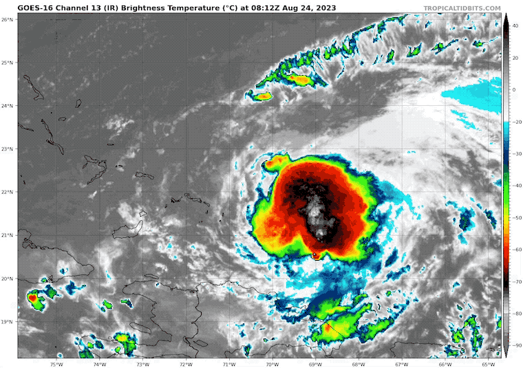
Forecast Track and Advisories From The National Hurricane Center
GFS Forecast Thursday Evening to Tuesday Evening
EXPLORE MORE
7 Day Forecast
Following our cool day today will be just one day of heat. It will not be as hot as earlier advertised. Then we step back to cooler weather to end the weekend.
Franklin will miss us but may influence the enhanced rainfall on Tuesday.
EARLIER THIS MONTH: Maryland Trek 10 For These Kids
I will have a follow-up and recap on our amazing week shortly.

Subscribe for eMail Alerts
EXPLORE MORE

Please share your thoughts, and best weather pics/videos, or just keep in touch via social media
RESTATING MY MESSAGE ABOUT DYSLEXIA
I am aware there are some spelling and grammar typos and occasional other glitches. I take responsibility for my mistakes, and even the computer glitches I may miss. I have made a few public statements over the years, but if you are new here you may have missed it: I have dyslexia, and found out during my second year at Cornell University. It didn’t stop me from getting my meteorology degree and being the first to get the AMS CBM in the Baltimore/Washington region. One of my professors told me that I had made it that far without knowing, and to not let it be a crutch going forward. That was Mark Wysocki and he was absolutely correct! I do miss my mistakes in my own proofreading. The autocorrect spell check on my computer sometimes does an injustice to make it worse. I also can make mistakes in forecasting. No one is perfect at predicting the future. All of the maps and information are accurate. The ‘wordy’ stuff can get sticky. There has been no editor who can check my work when I need it and have it ready to send out in a newsworthy timeline. Barbara Werner is a member of the web team that helps me maintain this site. She has taken it upon herself to edit typos when she is available. That could be AFTER you read this. I accept this and perhaps proves what you read is really from me… It’s part of my charm.
#FITF


