August 21: Three New Tropical Storms In The Atlantic and Hilary Update
August 21, 2023
Monday Morning Update
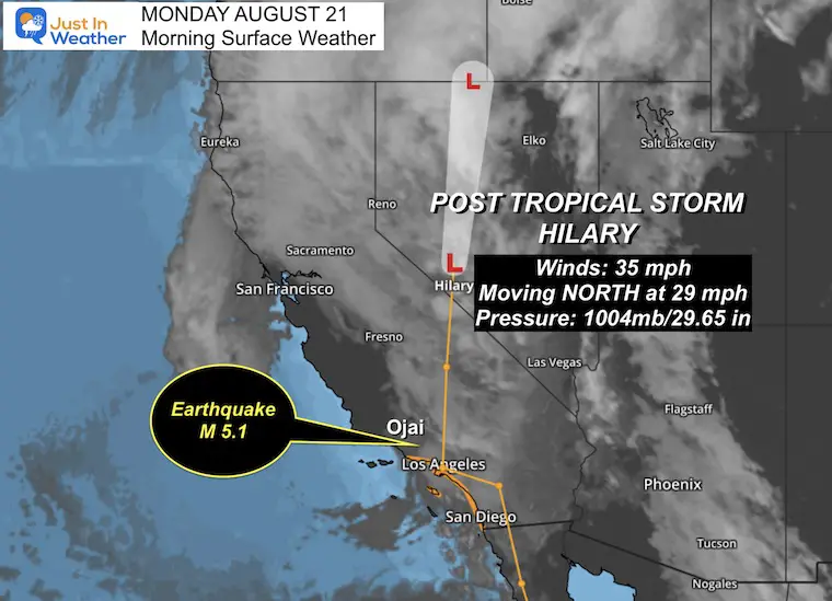
The hits keep on coming. Yesterday brought the path of Tropical Storm Hilary into California with flooding rain. While this was an historic event, it was coupled with an earthquake M 5.1. I have an update on the weather of now Post Tropical Storm Hilary below.
Now: Three NEW Tropical Storms have been named in the Atlantic. I mentioned this potential in my morning report on Sunday, but it may have been lost in the overload of news.
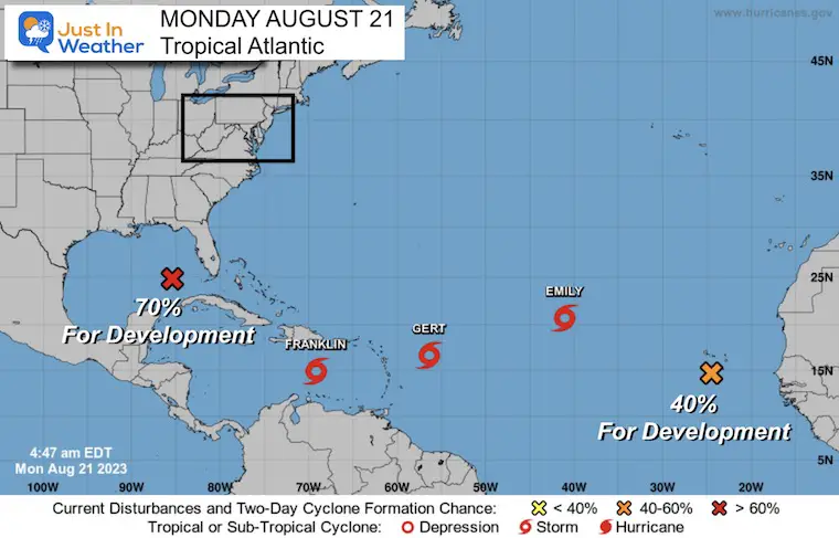
Tropical Atlantic Monday Morning
The National Hurricane Center has named Three NEW Tropical Storms AND has eyes on two other systems.
To be blunt: The 70% potential in the Gulf of Mexico is the only real threat to the US. This may form, get named, and make landfall in South Texas by the end of the week. The other storms likely stay away.
Tropical Storms Update
This is like watching popcorn. The water temperatures and conditions just hit the threshold, and Boom! Here we go with a very busy map:
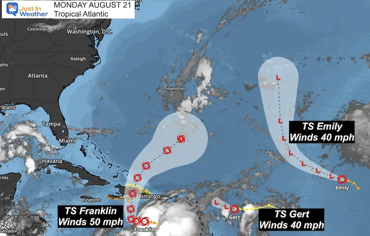
From West to East (note these were named in alphabetical order as they formed)
Tropical Storm Franklin
- Winds at 50 mph.
- Moving WEST at 10 mph.
- Expected to turn north over Hispaniola and then into the Central Atlantic.
Tropical Storm Gert
- Winds at 40 mph.
- Moving West at 9 mph.
- This may run out of a sustainable environment as upper-level winds could rip this apart in the next two days.
Tropical Storm Emily
- Winds at 40 mph.
- Moving West-Northwest at 12 mph.
- This is nowhere near land and not in a favorable location to do much than be a fish storm (remain at sea).
Tropical Wave
- Off the Cape Verde Islands near Africa, this has a 40% chance to develop in the next 5 days.
Hurricane Hilary Update
- Post Tropical Storm
- Winds 35 mph
- Moving North at 29 mph
Still able to produce life-threatening rainfall as flood waters are rising to record levels.
Click the photo for the Earthquake Report Sunday Evening
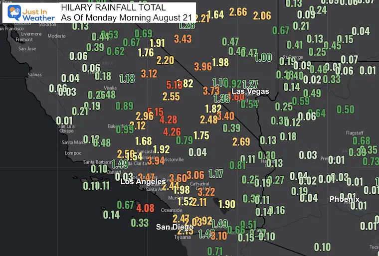
Rainfall As of Monday Morning
Many areas have received over 2 inches, with some reports over 5 inches.
Los Angeles has had over 3 inches. Near Las Vegas over 4 inches with ‘The Strip’ officially a record 0.34″.
There are many hills and mountains with burn scars from years of wildfires. These are most vulnerable to mudslides.
Record Flooding
The San Diego River is at the highest stage on the summer record:
The San Diego River at Fashion Valley had risen to 8.95 feet at 10:15 PM PDT and continues to rise. That appears to be the highest ever summertime level at that location, exceeding the 8.88 feet on July 20th, 2015. #cawx pic.twitter.com/iwfDWBhdb9
— NWS San Diego (@NWSSanDiego) August 21, 2023
Video of Flash Flooding In California
ATTN Drivers, please stay off the roads, if able. This video was taken by our #Caltrans8 Cajon Crew team wearing a head camera of SR-2 and Sheep Creek. Flash floods, high winds and the rain are making it a big challenge for all. Please be patient while we work. pic.twitter.com/BFga3z6JMG
— Caltrans District 8 (@Caltrans8) August 21, 2023
LA Dodger Stadium Surrounded By Flooding
Hurricane Hilary – Dodgers Stadium flooded 👀#Hilary #HurricaneHilary #California #Alert #Hurricane #PalmSprings #LosAngeles #LasVegas #SanDiego #earthquake #TropicalStorm #flooding pic.twitter.com/IGXWYkhfPH
— HumanDilemma (@HumanDilemma_) August 21, 2023
Coachella Valley/Palm Springs
VIDEO – Hilary has really picked up its intensity. Thunderbird Country Club Sunday afternoon by Sylvia Ender / @coachellavalley pic.twitter.com/OGlIHiVPM5
— Coachella Valley (@AnInsidersGuide) August 21, 2023
Debris Plume Flowing Down To Palm Springs
MASSIVE DEBRIS PLUG FLOODING HEADED FOR PALM SPRINGS! Crossed I-10! #CAwx @RadarOmega @ReedTimmerAccu @JimCantore LIVE: https://t.co/HhK4soO3Tg @NWSSanDiego pic.twitter.com/2ZhFt7jt5S
— Brandon Copic (@BrandonCopicWx) August 21, 2023
Palm Springs Street Flooding
This is the scene in Palm Springs, California.
Tropical storm Hilary has flooded the desert. pic.twitter.com/NRM7mxjnER
— Citizen Free Press (@CitizenFreePres) August 21, 2023
Live Radar Widget
Rain continues across the desert, even in Arizona this morning.
Use the controls to zoom in and pan the map
EXPLORE MORE
2023 Hurricane Season Forecast With An El Niño Watch
LOCAL WEATHER
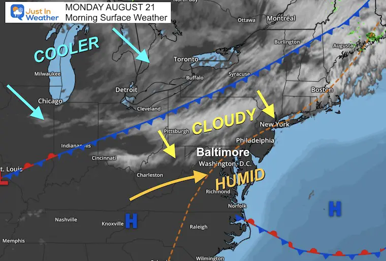
Morning Surface Weather
A cold front will be adding cloud cover. There are areas of fog and a more widespread muggy feeling in the region.
This cold front will be uneventful otherwise. The clouds will hold our temps from surging too high.
A cooler air mass will filter in tomorrow through midweek.
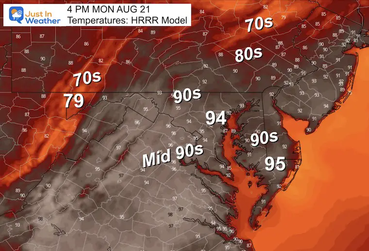
Afternoon Temperatures
COMPARE
The heat will be tamed a bit by the added cloud cover. It will be humid but should remain dry.
The HRRR Model is showing the highest temps, but I DO NOT THINK this is accounting for the added cloud cover.
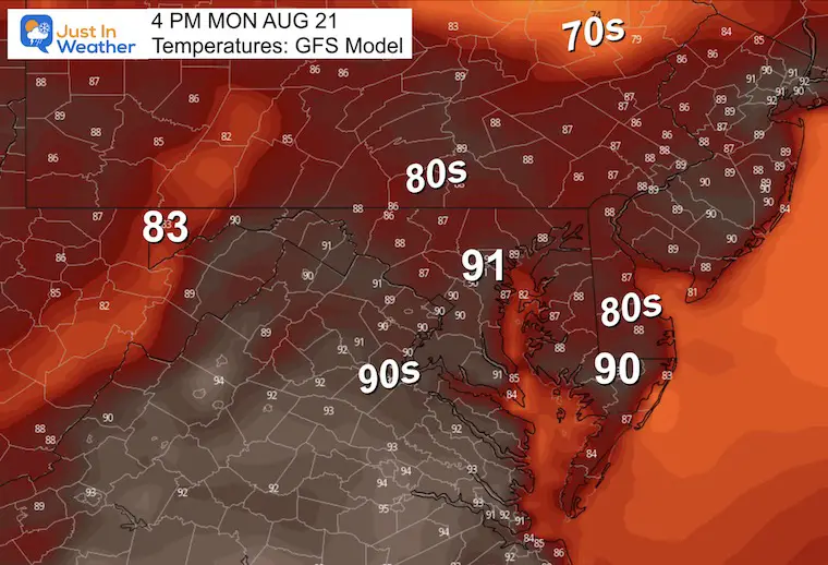
The GFS Model is matched by a few others, holding temps back if only by a few degrees.
CLIMATE DATA: Baltimore
TODAY August 21
Sunrise at 6:24 AM
Sunset at 7:53 PM
Normal Low in Baltimore: 65F
Record 51ºF in 2000
Normal High in Baltimore: 86ºF
Record 97ºF 1899
Subscribe for eMail Alerts
Weather posts straight to your inbox
Sign up and be the first to know!
Tuesday
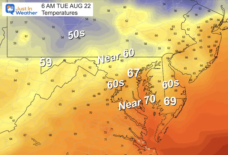
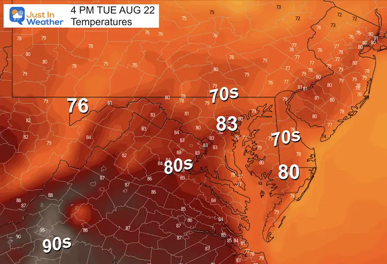
We may start warm and muggy, then clearing and lower humidity will lead to a cooler afternoon.
Morning Temperatures
Afternoon Temperatures
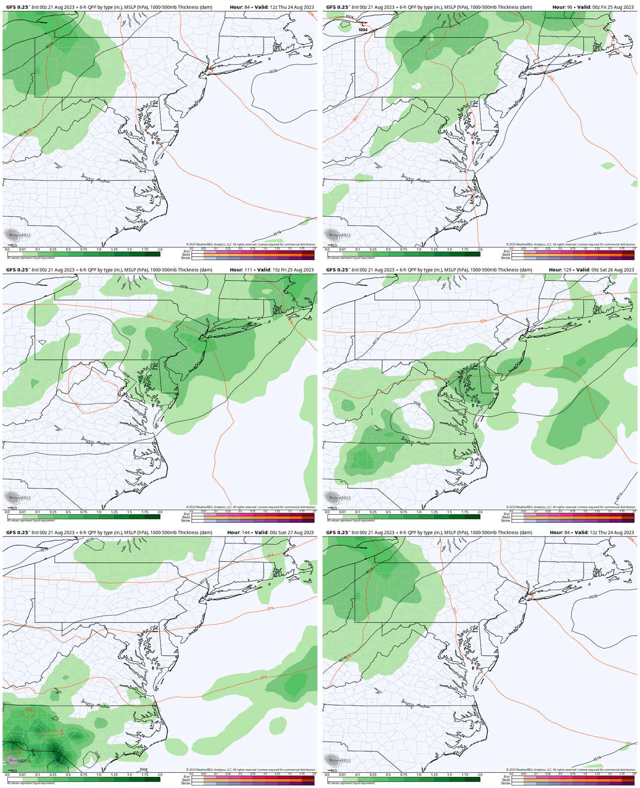
Looking Ahead: Thursday Morning To Friday Afternoon
Showers and Thunderstorms Thursday afternoon to Friday.
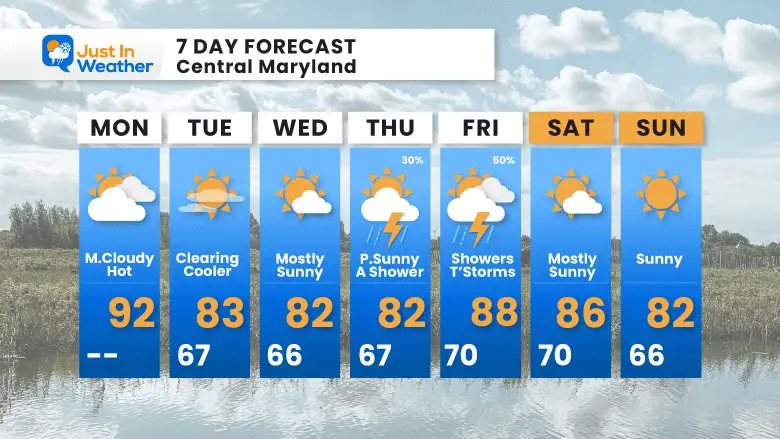
7 Day Forecast
This heat will end tomorrow with a new refreshing cooler air mass.
The next chance for rain will be with showers or thunderstorms Thursday and Friday. Next Weekend is looking good (for now).
LAST WEEK: Maryland Trek 10 For These Kids
I will have a follow-up and recap on our amazing week shortly.
Subscribe for eMail Alerts
Weather posts straight to your inbox
Sign up and be the first to know!
EXPLORE MORE
2023 Hurricane Season Forecast With An El Niño Watch
La Niña Has Ended. El Niño May Return By Fall
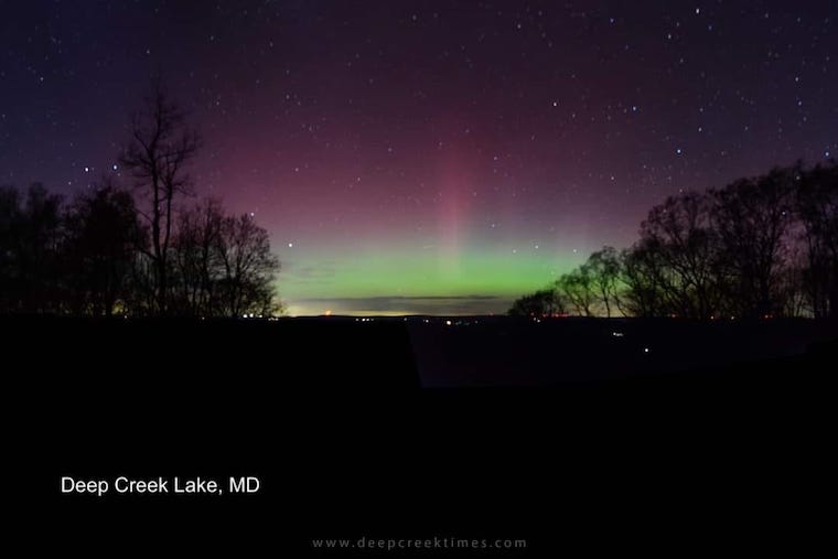
Aurora Photos From Maryland, Delaware, and Virginia
Please share your thoughts, and best weather pics/videos, or just keep in touch via social media
-
Facebook: Justin Berk, Meteorologist
-
Twitter
-
Instagram
RESTATING MY MESSAGE ABOUT DYSLEXIA
I am aware there are some spelling and grammar typos and occasional other glitches. I take responsibility for my mistakes, and even the computer glitches I may miss. I have made a few public statements over the years, but if you are new here you may have missed it: I have dyslexia, and found out during my second year at Cornell University. It didn’t stop me from getting my meteorology degree and being the first to get the AMS CBM in the Baltimore/Washington region. One of my professors told me that I had made it that far without knowing, and to not let it be a crutch going forward. That was Mark Wysocki and he was absolutely correct! I do miss my mistakes in my own proofreading. The autocorrect spell check on my computer sometimes does an injustice to make it worse. I also can make mistakes in forecasting. No one is perfect at predicting the future. All of the maps and information are accurate. The ‘wordy’ stuff can get sticky. There has been no editor that can check my work when I needed it and have it ready to send out in a newsworthy timeline. Barbara Werner is a member of the web team that helps me maintain this site. She has taken it upon herself to edit typos when she is available. That could be AFTER you read this. I accept this and perhaps proves what you read is really from me… It’s part of my charm.
#FITF


