July 26 Heat Wave Building And An End Over The Weekend
July 26, 2023
Wednesday Morning Update
I understand the news headlines have been smattered with mentions of heat, but our region has actually had two months below average. We do have a heat wave building this week and it could possibly reach 100ºF in urban areas, but the extreme weather will only last a day or two. There is an end in sight over the weekend.
Today we watch the warm up and with it may come more pollution and humidity. So it will gradually become less comfortable. The rain should hold off today, then turn stormy tomorrow night and Friday night.
Weather Alerts
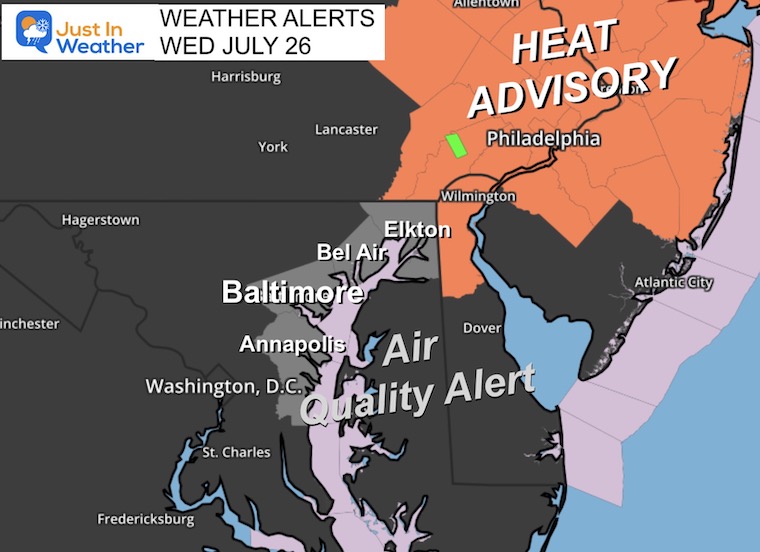
An Air Quality Alert has been issued along I-95 in Central Maryland including Annapolis and Baltimore up north to Philadelphia. This is unhealthy for sensitive groups and it is recommended to limit time outdoors mid-day and afternoon.
Heat Alert: Wilmington, DE to Philadelphia and New York. This will likely include much of Maryland tomorrow.
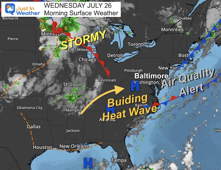
Morning Surface Weather
High Pressure is building in and allowing the Heat Wave to expand into our region.
The poor air quality today is likely to expand tomorrow.
Storms in the upper Midwest will begin to reach us tomorrow night.
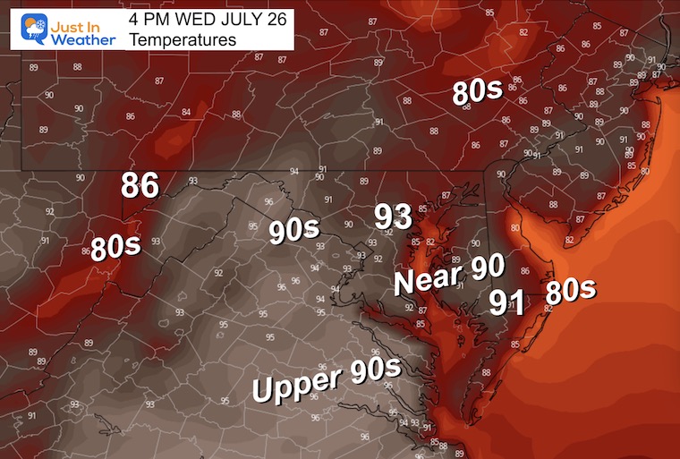
Afternoon Temperatures
EXPLORE MORE
2023 Hurricane Season Forecast With An El Niño Watch
Drought Report
https://justinweather.com/2023/07/20/severe-drought-remains-in-parts-of-maryland-july-20-2023/
Subscribe for eMail Alerts
Weather posts straight to your inbox
Sign up and be the first to know!
CLIMATE DATA
TODAY July 26
Normal Low in Baltimore: 68ºF
Record 55ºF in 1976
Normal High in Baltimore: 89ºF
Record 101ºF 1940
Thursday Weather
One of two very hot days. This will also bring in higher humidity and Heat Index values over 100ºF.
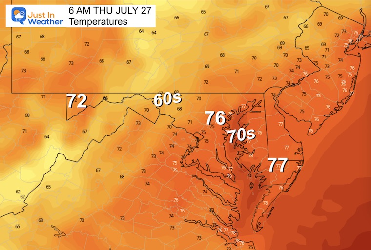
Morning Temperatures
Warm and muggy!
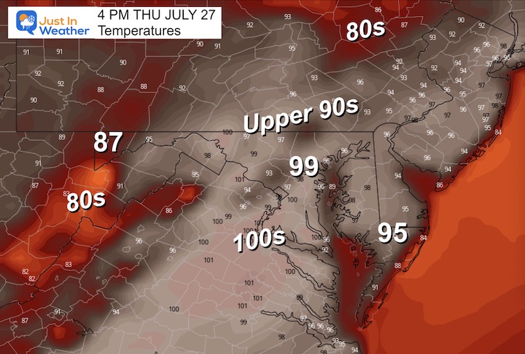
Afternoon Temperatures
Very hot temperatures with many reaching into the upper 90s and 100s more likely west and south of Washington.
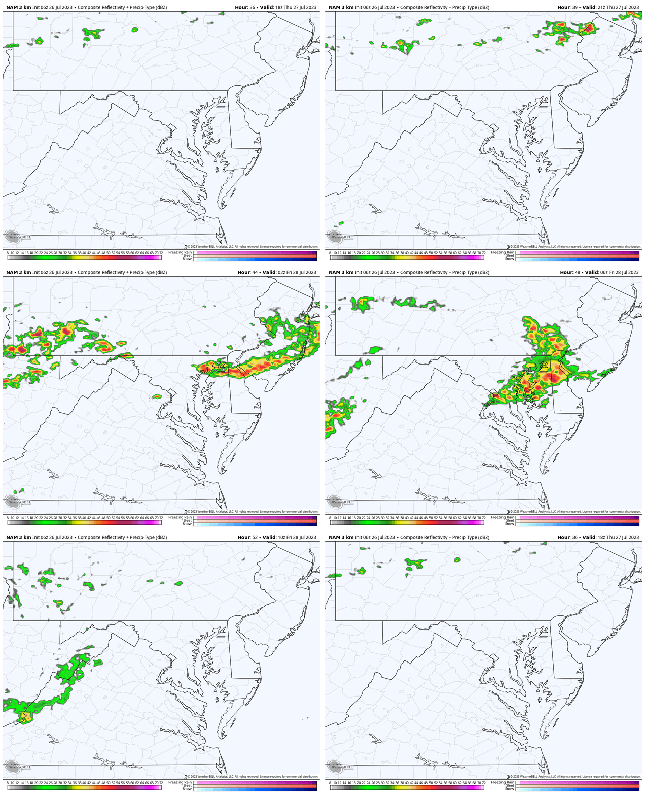
Radar Simulation 2PM to 2 AM
The expectation is for developing thunderstorms after dark for our region. This includes overnight… including Midnight and early Friday morning.
Rain Forecast: GFS Model
The heat will eventually give way to the next air mass. This cold front will approach with increasing showers and storms.
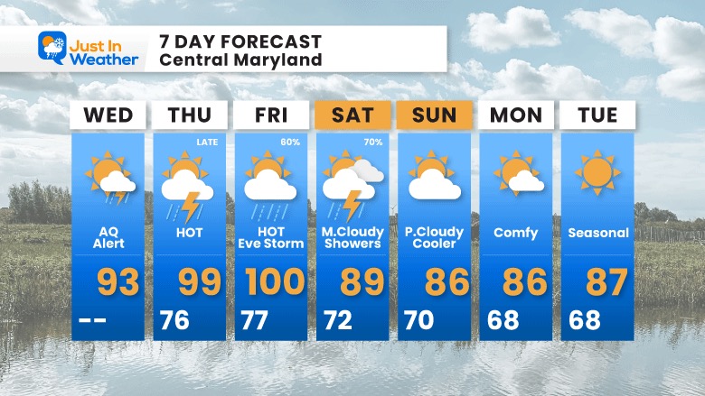
- Thursday: High Heat and thunderstorms at night.
- Friday: Another very HOT day with more evening showers and storms.
- Saturday: There will be more clouds and showers.
- Sunday: The fresh and cooler air mass is expected to be in place and last into next week.
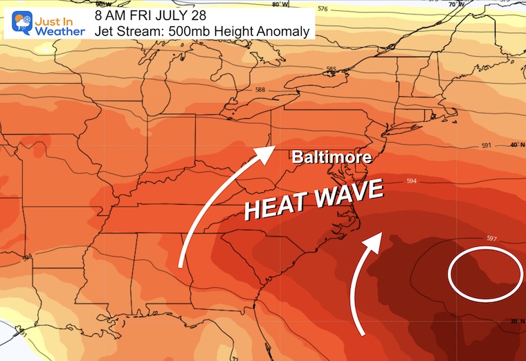
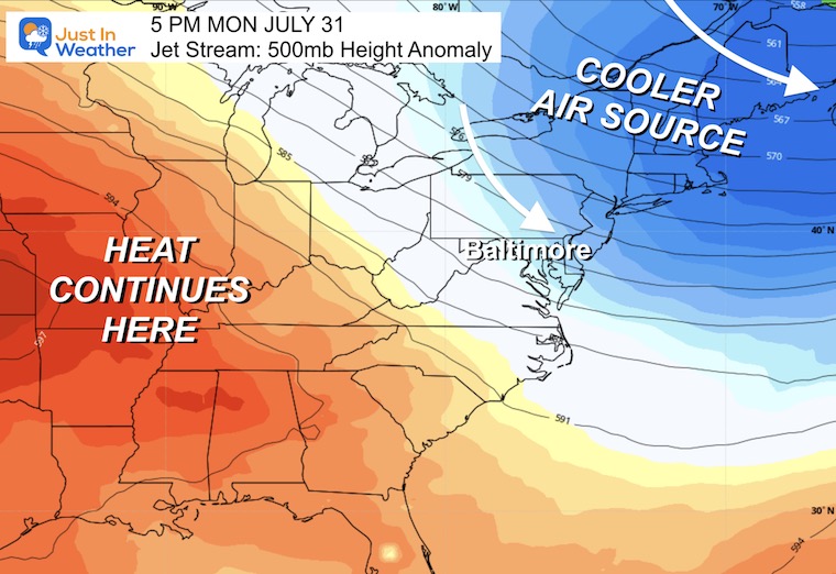
Jet Stream: Thursday to Monday
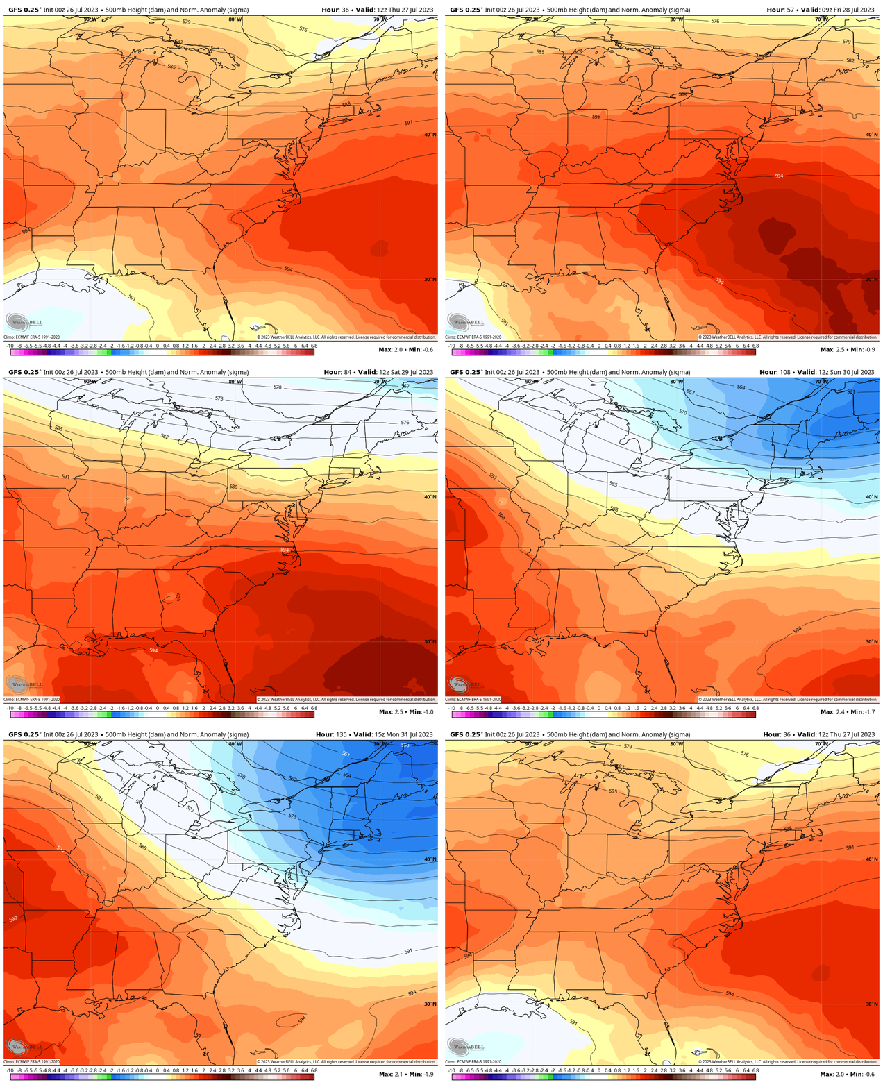
Friday:
Heat Wave
Monday:
Cooler Air Source From Canada.
7 Day Forecast
This is technically a heat wave and will feature high temperatures, but it will not be long-lasting. The peak heat will be on Thursday and Friday, and strong to severe storms are likely in the evenings or at night.
Saturday will be cloudy with more showers as the cold front brings in a cooler air mass.
Subscribe for eMail Alerts
Weather posts straight to your inbox
Sign up and be the first to know!
EXPLORE MORE
2023 Hurricane Season Forecast With An El Niño Watch
La Niña Has Ended. El Niño May Return By Fall
Aurora Photos From Maryland, Delaware, and Virginia
Please share your thoughts, and best weather pics/videos, or just keep in touch via social media
-
Facebook: Justin Berk, Meteorologist
-
Twitter
-
Instagram
RESTATING MY MESSAGE ABOUT DYSLEXIA
I am aware there are some spelling and grammar typos and occasional other glitches. I take responsibility for my mistakes, and even the computer glitches I may miss. I have made a few public statements over the years, but if you are new here you may have missed it: I have dyslexia, and found out during my second year at Cornell University. It didn’t stop me from getting my meteorology degree, and being the first to get the AMS CBM in the Baltimore/Washington region. One of my professors told me that I had made it that far without knowing, and to not let it be a crutch going forward. That was Mark Wysocki and he was absolutely correct! I do miss my mistakes in my own proofreading. The autocorrect spell check on my computer sometimes does an injustice to make it worse. I also can make mistakes in forecasting. No one is perfect predicting the future. All of the maps and information are accurate. The ‘wordy’ stuff can get sticky. There has been no editor that can check my work when I needed it and have it ready to send out in a newsworthy timeline. Barbara Werner is a member of the web team that helps me maintain this site. She has taken it upon herself to edit typos, when she is able. That could be AFTER you read this. I accept this and perhaps proves what you read is really from me… It’s part of my charm.
#FITF


