July 25 NOAA Severe Storm Risk Today Then Our Heat Wave
July 25, 2023
Tuesday Morning Update
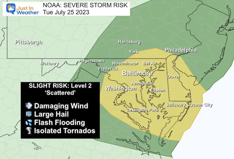
After a smattering of storms yesterday, we remain in an unstable environment. Today a trough will swing through mid-day and ignite more powerful storms, some of which can turn severe. This risk has been highlighted by NOAA with a Slight Risk bullseye around metro Baltimore and central Maryland.
There seems to be a delay of the true heat, which means when it gets here we may see an extra day on the back end. So high heat arrives tomorrow and may last into Saturday. The end is subject to the next cold front and widespread bands of clouds and rain. I am planning for Sunday to be the better day of the weekend.
NOAA Severe Storm Risk Today
The Slight Risk is Level 2. It basically means we will have strong storms with a scattering of cells turning severe.. but not all will.
The level to have a Warning issued is:
- Winds OVER 58 mph
- Hail OVER 1 inch diameter
- Flash Flooding
- Isolated Tornadoes
Please Note: Any storm can produce dangerous lightning. This means cloud-to-ground strikes. The bolts BEFORE the first drop of rain tend to be the ones that can be deadly. So please don’t wait for the rain! If you hear thunder, go indoors and be cautiously safe.
Morning Surface Weather
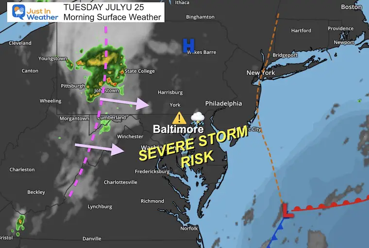
The disturbance in western Pennsylvania and Maryland will be the focus for severe storms today. This has already produced a band of clouds and rain this morning. It will reach our region by noon and shift through the southern/eastern areas to the coast by tonight.
Live Radar and Lightning Widget
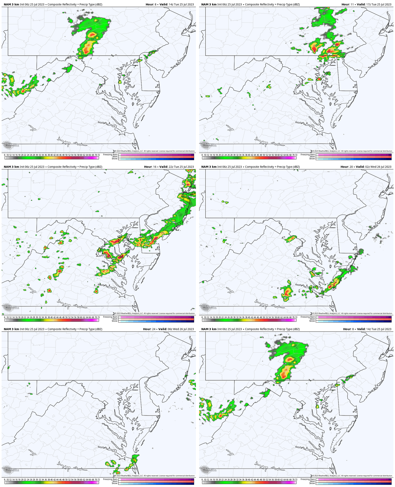
Forecast Radar: 10 AM to Midnight
Repeat: I do NOT trust or have high confidence in this product. So we use this as a suggestion.
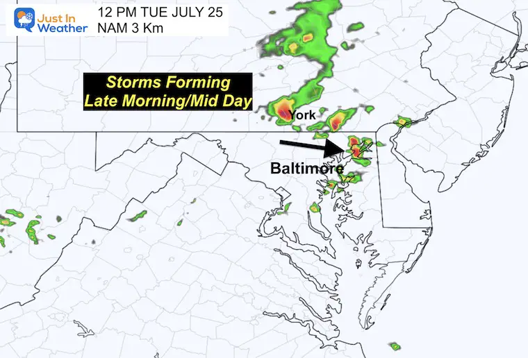
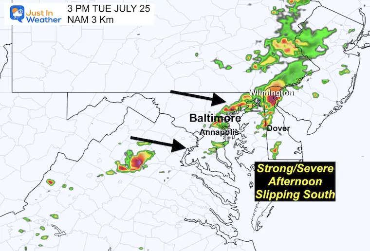
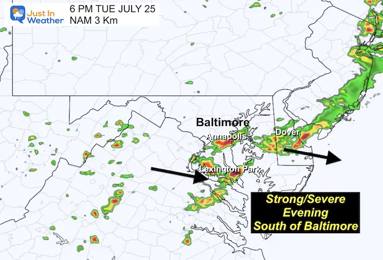
We may see the flare-up of storms near the Pennsylvania/Maryland border by mid-day. Then this developing line slips south through metro Baltimore mid afternoon, and southern Maryland this evening and tonight.
12 PM Snapshot
3 PM Snapshot
6 PM Snapshot
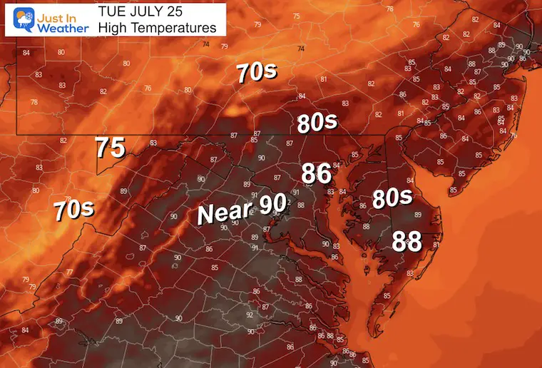
Afternoon Temperatures
EXPLORE MORE
2023 Hurricane Season Forecast With An El Niño Watch
Drought Report
https://justinweather.com/2023/07/20/severe-drought-remains-in-parts-of-maryland-july-20-2023/
Subscribe for eMail Alerts
Weather posts straight to your inbox
Sign up and be the first to know!
CLIMATE DATA
TODAY July 25
Normal Low in Baltimore: 68ºF
Record 57ºF in 2014
Normal High in Baltimore: 89ºF
Record 100ºF 2016
Wednesday Weather
The stormy pattern should move away and we get into the hot air mass with a dry day.
Morning Temperatures
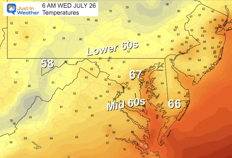
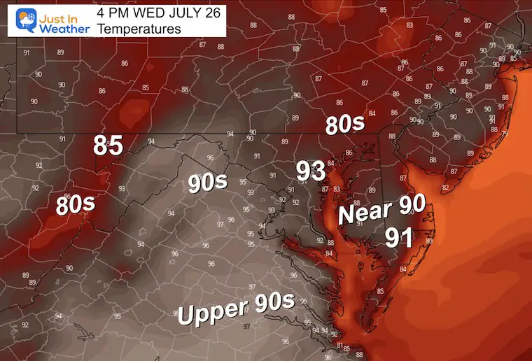
Afternoon Temperatures
These cooler numbers reflect the influence of more clouds and showers.
Heat Index values may approach 100ºF.
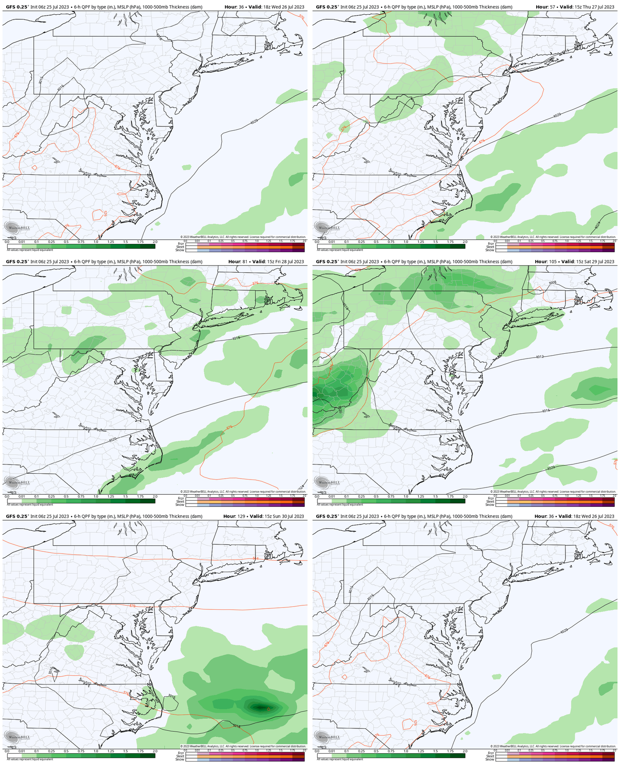
Rain Forecast: GFS Model
The heat will eventually give way to the next air mass. This cold front will approach with increasing showers and storms.
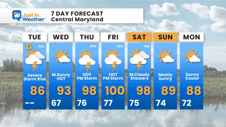
- Wednesday: Dry
- Thursday: High Heat and thunderstorms in the evening and at night.
- Friday: Another very HOT day with more showers and possible severe storms.
- Saturday: There will be more clouds and showers. The big question is if we sneak in one more very hot day or if temps settle back with less sun.
- Sunday: This is expected to be the other side and into a new/cooler air mass.
7 Day Forecast
One more day with storms, then the heat wave will build in. It looks like this one day delay may extend it on the back end. The debate is about Saturday and whether we reach the upper 90s to 100ºF again or remain cooler due to more clouds and showers.
Subscribe for eMail Alerts
Weather posts straight to your inbox
Sign up and be the first to know!
EXPLORE MORE
2023 Hurricane Season Forecast With An El Niño Watch
La Niña Has Ended. El Niño May Return By Fall
Aurora Photos From Maryland, Delaware, and Virginia
Please share your thoughts, and best weather pics/videos, or just keep in touch via social media
-
Facebook: Justin Berk, Meteorologist
-
Twitter
-
Instagram
RESTATING MY MESSAGE ABOUT DYSLEXIA
I am aware there are some spelling and grammar typos and occasional other glitches. I take responsibility for my mistakes, and even the computer glitches I may miss. I have made a few public statements over the years, but if you are new here you may have missed it: I have dyslexia, and found out during my second year at Cornell University. It didn’t stop me from getting my meteorology degree, and being the first to get the AMS CBM in the Baltimore/Washington region. One of my professors told me that I had made it that far without knowing, and to not let it be a crutch going forward. That was Mark Wysocki and he was absolutely correct! I do miss my mistakes in my own proofreading. The autocorrect spell check on my computer sometimes does an injustice to make it worse. I also can make mistakes in forecasting. No one is perfect predicting the future. All of the maps and information are accurate. The ‘wordy’ stuff can get sticky. There has been no editor that can check my work when I needed it and have it ready to send out in a newsworthy timeline. Barbara Werner is a member of the web team that helps me maintain this site. She has taken it upon herself to edit typos, when she is able. That could be AFTER you read this. I accept this and perhaps proves what you read is really from me… It’s part of my charm.
#FITF


