April 24 Aurora Photos And Weather Brings Late Season Frost Late Week Rain
April 24, 2023
Monday Morning Update
You may be waking up to clouds and rain showers, but we did get enough clearing last night to allow for some viewing of the Aurora into The Mid Atlantic US. The severe geomagnetic storm that flushed Earth did live up to expectations. I gathered a few photos locally and around the world to share before our weather report. More pics may be available later today.
Note that the weather has frost in southern PA this morning and will expand that to inland Maryland tomorrow. Then we will set up a rainy pattern for the last half of this week.
Aurora Update
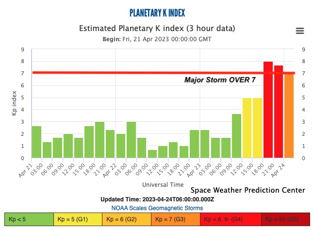
Planetary K-index
The Severe Storm did peak at 8, which is on the threshold for a bright event to push the Northern Lights farther south in latitude.
Stonehenge Aurora
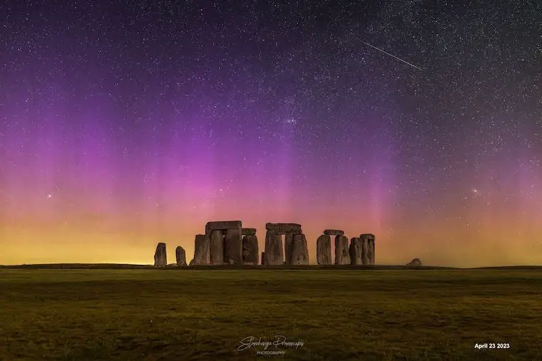
One of the more spectacular views was seen over Stonehenge in the UK. This may end up on a widely distributed poster or high gloss photo near you.
UPDATE:
Click here to see Photos Aurora From Maryland, Delaware, and Virginia.
See the photographer here
Aurora pillars from just west of St Louis, MO at 10pm. #mowx pic.twitter.com/2LIX1LaitU
— Peter Forister ⚡️🌪️⚡️ (@forecaster25) April 24, 2023
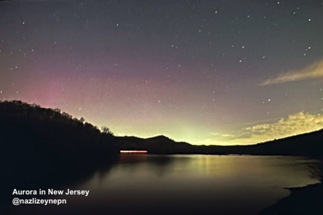
New Jersey Aurora
This glowing view was captured by…
Maryland Aurora Lights
Central Maryland did get a faint view as shown by James Wilinghan. He identified that there was clearing after sunset.
Aurora over central Maryland April 23rd. Clouds blocked the view after sunset and once cleared activity seemed to be calming down this far south, but there was still some activity to be pulled out with the camera. @JustinWeather pic.twitter.com/ZjGWEqZD31
— James Willinghan (@JamesWillinghan) April 24, 2023
St. Louis Aurora Lights
This is at a similar altitude to Baltimore and has a wonderful display seen here.
Aurora pillars from just west of St Louis, MO at 10pm. #mowx pic.twitter.com/2LIX1LaitU
— Peter Forister ⚡️🌪️⚡️ (@forecaster25) April 24, 2023
Kaleidoscope Aurora in Montana
Cory Mottice captured what looked like a tied-eye shirt at a Grateful Dead Concert at times.
Quite the impressive show tonight from Billings, MT! Unfortunately my tripod broke so I had to make due with what I had, but still got some pretty cool shots. Easily the brightest #aurora I have seen so far. Lit up the ground brighter than a full moon for a time! #mtwx pic.twitter.com/UTcp6eNRgb
— Cory Mottice (@EverythingWX) April 24, 2023
WEATHER REPORT
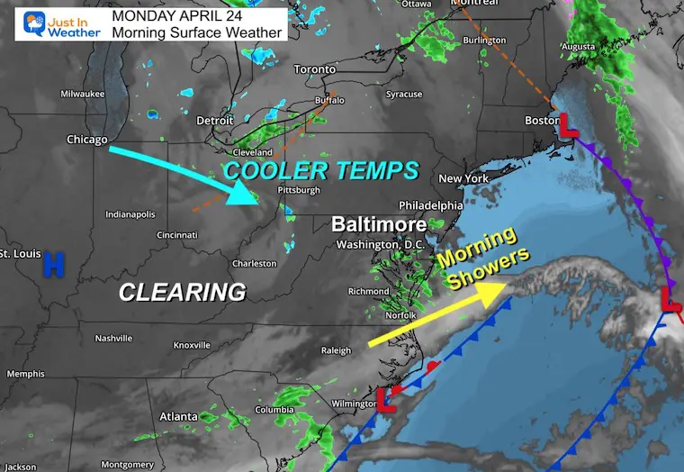
Morning Surface Weather
A disturbance has brought a cluster of clouds and rain showers to southern Maryland and Delmarva… and it’s moving away.
High Pressure is building in from Illinois and will help to bring more sun with chilly temps.
Temperatures
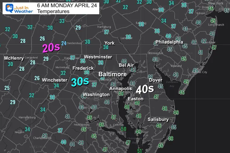
Morning Observations
Look at the cold! 20s in the mountains and 30s have reached the inland suburbs. It will be colder tomorrow morning.
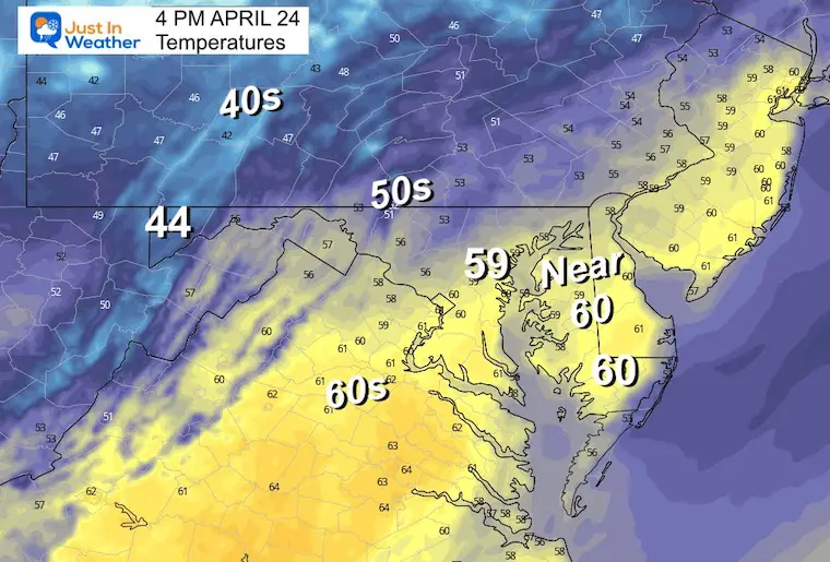
Afternoon Forecast
Most areas in the 50s, to near 60ºF for Baltimore and around Delmarva.
Subscribe for eMail Alerts
Weather posts straight to your inbox
Sign up and be the first to know!
CLIMATE DATA
TODAY April 24
Normal Low in Baltimore: 47ºF
Record 32ºF in 2003
Snow: Trace in 1930
Normal High in Baltimore: 70ºF
Record 93ºF in 1960
REPORTS:
NEW: April Heat Wave History
Winter 2023 Recap: My BUSTED Snow Outlook
La Niña Has Ended. El Niño May Return By Fall
Tuesday Temperatures
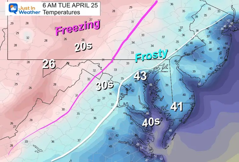
Morning
Inland Frost! An Advisory is likely to be issued for counties west and north of Baltimore. Milder 40s likely from the city and around the Bay.
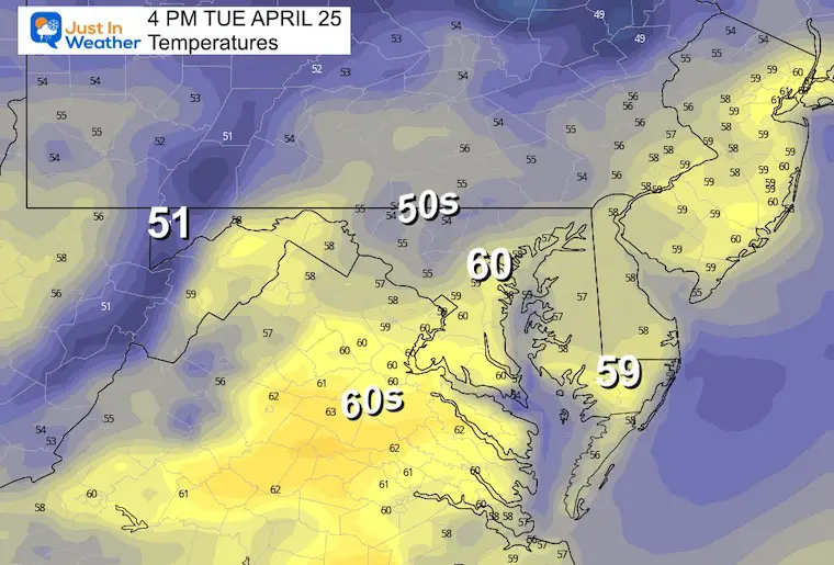
Afternoon Temperatures
Another chilly afternoon with mid 50s to near 60s.
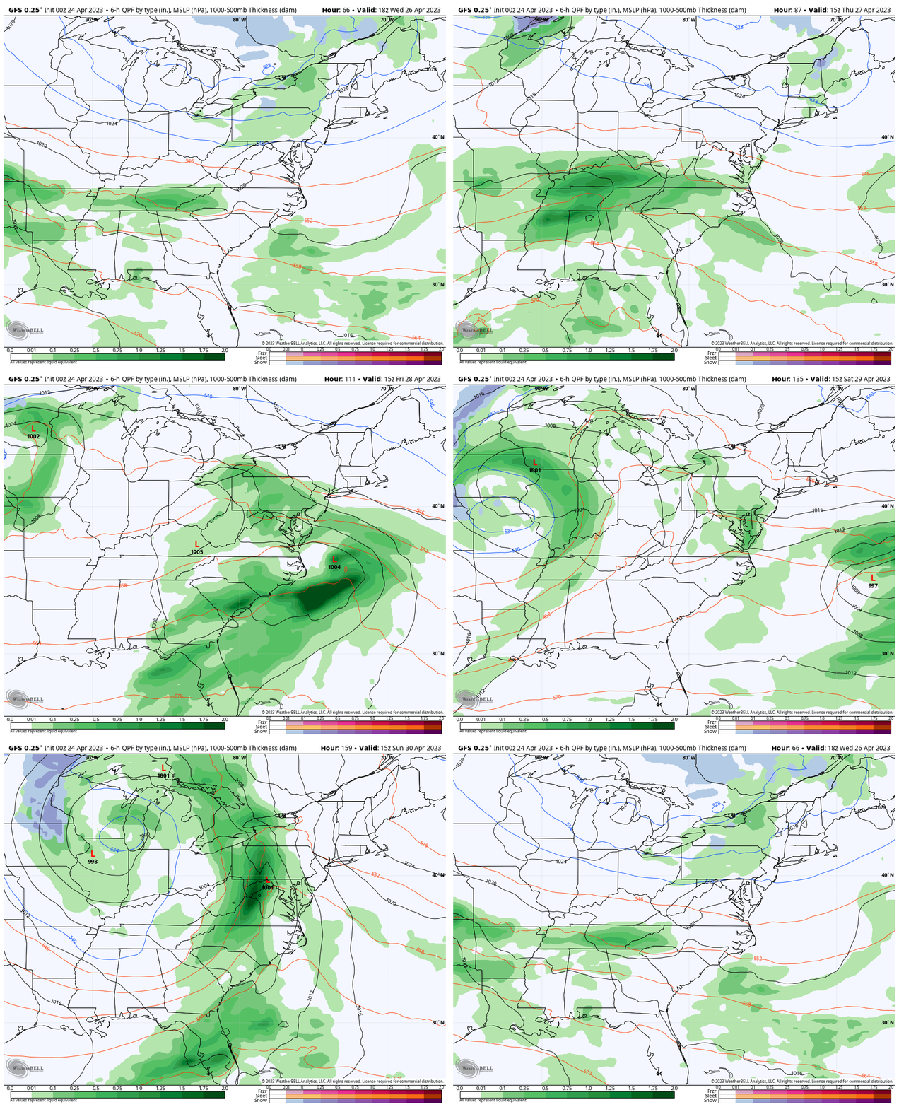
Storm Forecast Animation
Wednesday Afternoon to Sunday Night
A stormy pattern will bring a few rounds of chilly rain our way for the last half of the week. Yes, this will affect the weekend.
Snapshots: There will be some adjustment as we get closer, but this looks like a few systems will affect us with rain almost every day after Wednesday to the weekend.
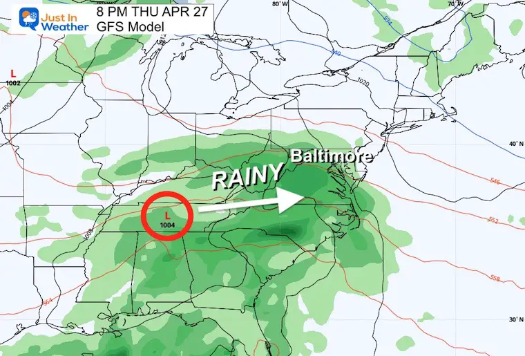
Thursday Evening
A larger storm will be arriving from the west. Rain arrives late in the day and sticks around for a while.
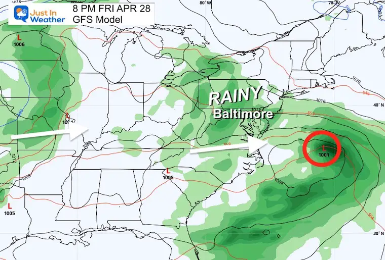
Friday Evening
The storm moving well off the coast, but upper level disturbance will keep the unsettled, cool and wet weather in place.
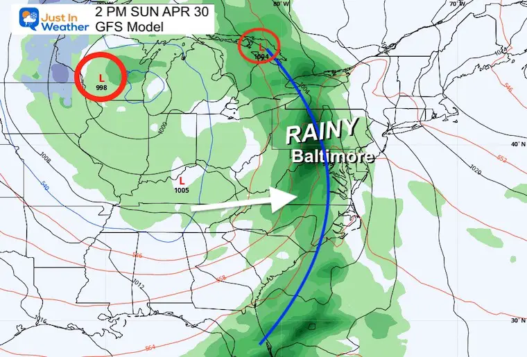
Sunday Afternoon
This may bring heavier rain and a thunderstorm with the cold front.
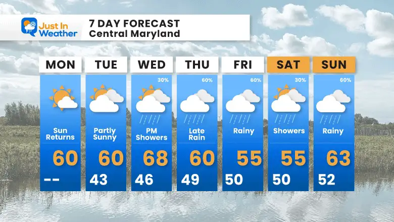
7 Day Forecast
The over-correction I have been mentioning will be felt this week. After a late season frost tomorrow morning, the end of the week will feature a rainy pattern. This will be a chance to make a dent in our drought.
STEM Assemblies/In School Fields Trips Are Back
Click to see more and ‘Book’ a visit to your school
Please share your thoughts, best weather pics/videos, or just keep in touch via social media
-
Facebook: Justin Berk, Meteorologist
-
Twitter
-
Instagram
RESTATING MY MESSAGE ABOUT DYSLEXIA
I am aware there are some spelling and grammar typos, and occasional other glitches. I take responsibility for my mistakes, and even the computer glitches I may miss. I have made a few public statements over the years, but if you are new here you may have missed it: I have dyslexia, and found out during my second year at Cornell University. It didn’t stop me from getting my meteorology degree, and being first to get the AMS CBM in the Baltimore/Washington region. One of my professors told me that I had made it that far without knowing, and to not let it be a crutch going forward. That was Mark Wysocki and he was absolutely correct! I do miss my mistakes in my own proofreading. The autocorrect spell check on my computer sometimes does an injustice to make it worse. I also can make mistakes in forecasting. No one is perfect predicting the future. All of the maps and information are accurate. The ‘wordy’ stuff can get sticky. There has been no editor that can check my work when I needed it and have it ready to send out in a newsworthy timeline. Barbara Werner is a member of the web team that helps me maintain this site. She has taken it upon herself to edit typos, when she is able. That could be AFTER you read this. I accept this and perhaps proves what you read is really from me… It’s part of my charm.
#FITF


