April 13, 2023
Thursday Morning Update
Summer heat continues today. You will notice a very mild start to the day and afternoon temperatures even warmer than yesterday. Baltimore topped out at 85ºF, so today will be higher and closer to the record high. This ‘heat wave’ will come to an end with a cooler weekend and risk for rain. Next week will be noticeably cooler as we return closer to ‘normal’.
Fire Weather: Elevated Risk
It is important to note that natural ignition for fires is lightning, and we do not have that in our forecast. So any fires would be started by humans. We should take this seriously as anything from a cigarette to backyard grill or fire pit can lead to uncontrolled flames.
Brush fire in Rosedale, MD
This fire shut down the Baltimore Beltway.
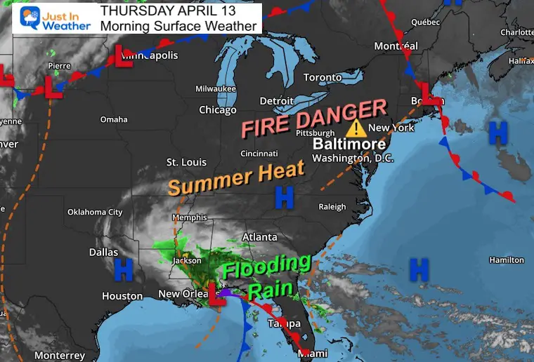
Morning Surface Weather
High Pressure remains in control.
Meanwhile along the Gulf Coast there is a slow moving storm with tropical downpours. Flooding was extensive in South Florida yesterday, and there may be more flooding near this storm center today.
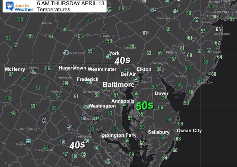
Morning Temperatures
A mild start already this morning.
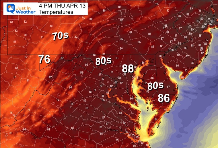
Afternoon Temperatures
The record for Baltimore was 89ºF set in 1977. Today will be close and NOTE BWI tends to run warmer than surrounding areas.
Subscribe for eMail Alerts
CLIMATE DATA
TODAY April 13
Normal Low in Baltimore: 42ºF
Record 26ºF in 1973
SNOW: 0.4” in 1957
Normal High in Baltimore: 66ºF
Record 89ºF in 1977
REPORTS:
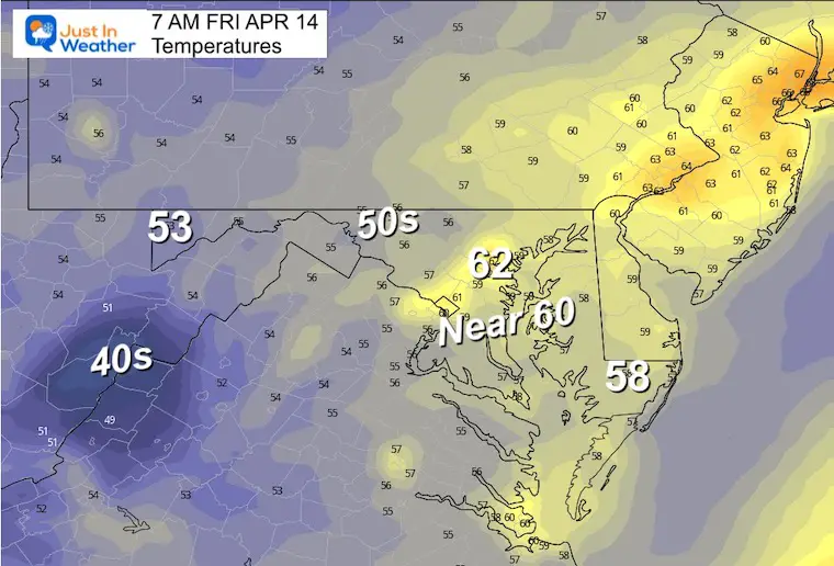
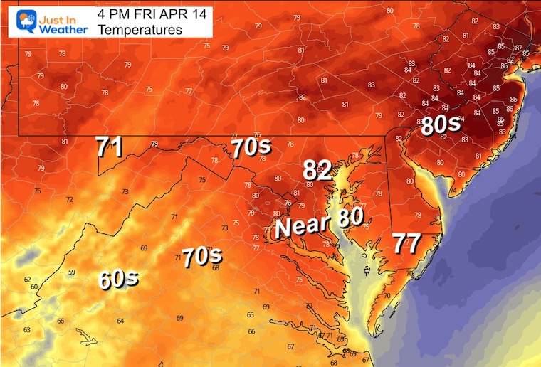
Friday Morning Temperatures
Friday Afternoon Temperatures
Not as warm with more cloud cover, but still above average.
Weekend Weather
A disturbance will bring scattered showers on Saturday. This will NOT be a washout. It will be tough to pin down specific locations and timing of the showers until we get closer. So for now, just keep it as part of your planning.
Sunday will be warm and more likely to hold off the storms until evening and overnight.
NAM 3 Km Model Animation
8 AM to 2 PM Saturday
A band of showers will be expanding up from the south. They will be scattered, but will affect much of the region at some point. I know that is vague, but it is tough to pin down specific locations and times right now.
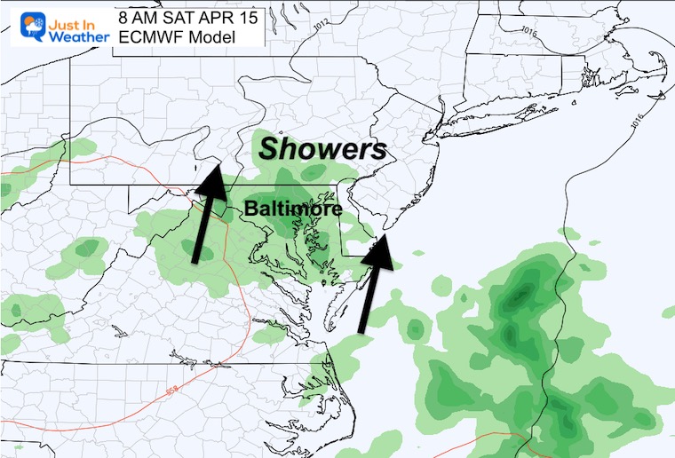
ECMWF Model
Snapshot Saturday Morning
This product looks a little more widespread with the showers.
Model Animation
Sat 8 AM to Mon 8 AM
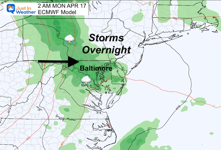
Snapshot Sunday Night
At this time it looks like a mostly dry day, with showers arriving from the mountains in the evening and overnight.
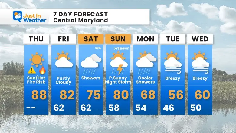
7 Day Forecast
Showers on Saturday will be scattered but worth considering for your outdoor plans.
Storms on Sunday night are likely to arrive AFTER sunset and move out Monday morning, when cooler temps arrive.
STEM Assemblies/In School Fields Trips Are Back
Click to see more and ‘Book’ a visit to your school

Please share your thoughts, best weather pics/videos, or just keep in touch via social media
RESTATING MY MESSAGE ABOUT DYSLEXIA
I am aware there are some spelling and grammar typos, and occasional other glitches. I take responsibility for my mistakes, and even the computer glitches I may miss.
I have made a few public statements over the years, but if you are new here you may have missed it:
I have dyslexia, and found out during my second year at Cornell University. It didn’t stop me from getting my meteorology degree, and being first to get the AMS CBM in the Baltimore/Washington region. One of my professors told me that I had made it that far without knowing, and to not let it be a crutch going forward. That was Mark Wysocki and he was absolutely correct!
I do miss my mistakes in my own proofreading. The autocorrect spell check on my computer sometimes does an injustice to make it worse. I also can make mistakes in forecasting. No one is perfect predicting the future.
All of the maps and information are accurate. The ‘wordy’ stuff can get sticky.
There has been no editor that can check my work when I needed it and have it ready to send out in a newsworthy timeline. Barbara Werner is a member of the web team that helps me maintain this site. She has taken it upon herself to edit typos, when she is able. That could be AFTER you read this.
I accept this and perhaps proves what you read is really from me…
It’s part of my charm.
#FITF


