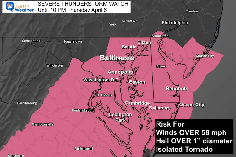
Follow up on the prior report, this Severe Thunderstorm Watch until 10 PM has been expected. The anticipation is that a line of strong thunderstorms will develop after 4 PM and may contain wind speeds over 58 mph and or large hail over 1 inch in diameter.The parameters support some storms could include hail up to 2 inches or ping pong ball size, in portions of Southern Maryland and Delmarva.
The Watch includes counties in Maryland from metro Baltimore through the Eastern Shore, all of Delaware, and north central Virginia. Once the line of storms moves through, the watch will likely be canceled earlier in the western areas, then later towards the beaches.
Maryland Counties
ANNE ARUNDEL
BALTIMORE
CALVERT
CAROLINE
CECIL
CHARLES
DORCHESTER
HARFORD
HOWARD
KENT
MONTGOMERY
PRINCE GEORGES
QUEEN ANNE`S
SOMERSET
ST. MARYS
TALBOT
WICOMICO
WORCESTER
Delaware Counties
KENT
NEW CASTLE
SUSSEX
When storms form and reach those limits, ‘Warnings’ will be issued as the cells can be tracked across towns with a specific timeline.
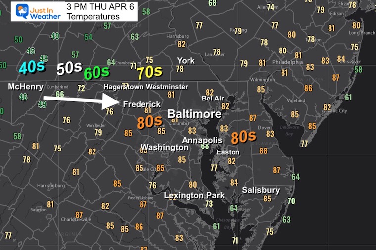
Widespread coverage of 80s, but check out the DROP to the WEST! 50s and 40s in the mountains. That contrast is part of the fuel for this storm line developing.
Subscribe for eMail Alerts
Weather posts straight to your inbox
Sign up and be the first to know!
From my prior report:
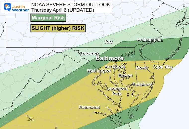
NOAA updated their risk for severe storms and shifted the focus a little farther north. I understand these parameters can be confusing. The conditions are present to produce a line of thunderstorms that may turn severe. This means they can produce winds over 58 mph, hail over 1 inch diameter, and isolated tornados.
NOAA Severe Storm Risk
This is why the Baltimore Orioles home opener was postponed until tomorrow.
The greatest chance will be EAST of Rt. 15, SOUTH of I-70, and NEAR/SOUTH of I-95.
The Marginal (lower) Risk does include metro Baltimore. A lower chance farther west and north for storms to develop or cause problems as the boundary is expected to be farther south.
Slight (higher) Risk includes Washington, Annapolis, Southern Maryland, Eastern Shore (Easton, Cambridge, Salisbury), Southern Delaware, and The Beaches.
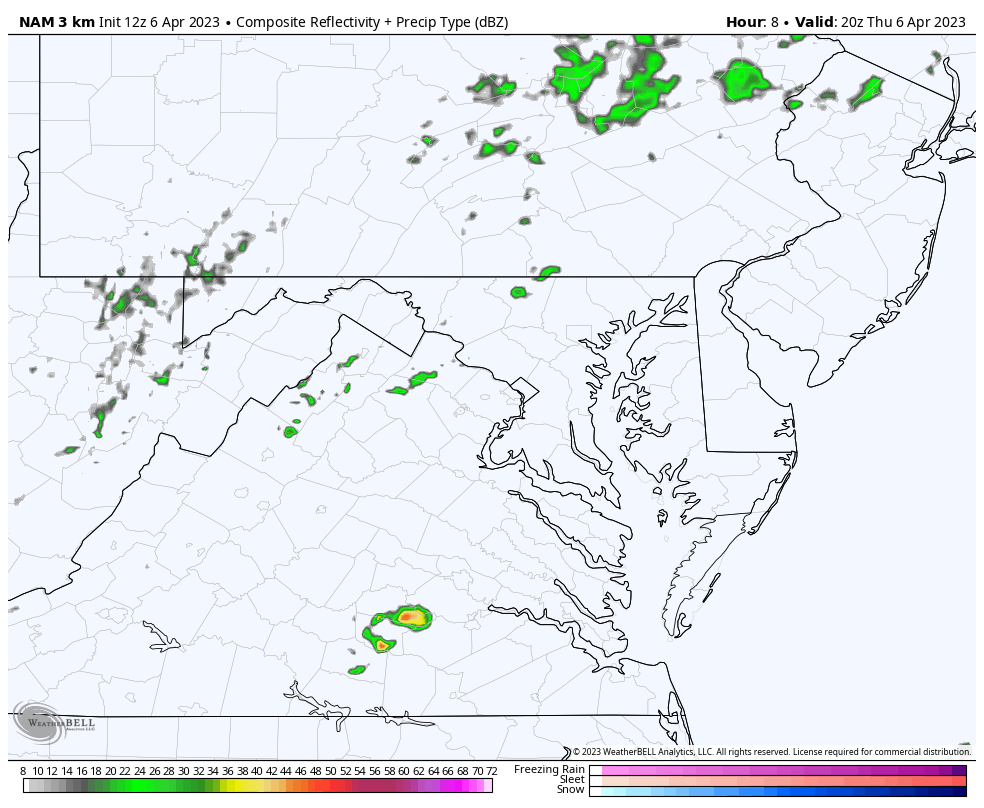
Radar Simulation
NAM 3 Km Model 4 PM to Midnight
Timeline —> slider
The peak time will be AFTER 5 PM.
Please note that this product may be off by 1 to 2 hours. This is the best we have for now. Compare to the LIVE Radar Widget below.
april-6-weather-storm-radar-nam-thursday-pm-4
april-6-weather-storm-radar-nam-thursday-pm-5
april-6-weather-storm-radar-nam-thursday-pm-6
april-6-weather-storm-radar-nam-thursday-pm-7
april-6-weather-storm-radar-nam-thursday-pm-8
april-6-weather-storm-radar-nam-thursday-pm-9
april-6-weather-storm-radar-nam-thursday-pm-10
Live Radar Widget
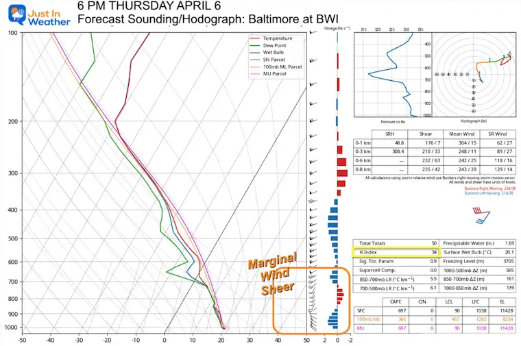
Forecast Atmospheric Sounding
Here is a quick look at the latest model simulation to help with the location and timeline. Starting with this forecast sounding over Baltimore this evening, it looks like the greatest risk will be damaging wind and hail. The tornado risk is low. It is possible farther south, but still low.
My 5oth Birthday Fundraiser: Supporting Just In Power Kids and kicking off my 10th Maryland Trek. This is on Facebook and they give 100% to the cause with no fees. 100% will go to our programs.
I am aware there are some spelling and grammar typos, and occasional other glitches. I take responsibility for my mistakes, and even the computer glitches I may miss.
I have made a few public statements over the years, but if you are new here you may have missed it:
I have dyslexia, and found out during my second year at Cornell University. It didn’t stop me from getting my meteorology degree, and being first to get the AMS CBM in the Baltimore/Washington region. One of my professors told me that I had made it that far without knowing, and to not let it be a crutch going forward. That was Mark Wysocki and he was absolutely correct!
I do miss my mistakes in my own proofreading. The autocorrect spell check on my computer sometimes does an injustice to make it worse. I also can make mistakes in forecasting. No one is perfect predicting the future.
All of the maps and information are accurate. The ‘wordy’ stuff can get sticky.
There has been no editor that can check my work when I needed it and have it ready to send out in a newsworthy timeline. Barbara Werner is a member of the web team that helps me maintain this site. She has taken it upon herself to edit typos, when she is able. That could be AFTER you read this.
I accept this and perhaps proves what you read is really from me…