March 9 Less Wind Today Then Wintry Mix Friday
March 9, 2023
Thursday Morning
Today will be sunny and LESS Windy! That’s the good news. The other part of this forecast is that temperatures mainly stay near or above freezing. We will get snow developing on Friday and maybe again Sunday night. However, the temperatures locally will not support stickage. If you are traveling to the western Maryland Mountains or to Pennsylvania that may be a different story.
Storm Details: I am doing my best to explain this set up with many maps and simple wording so that even if you are in a warmer area you can see it may not be the same just 20 miles away.
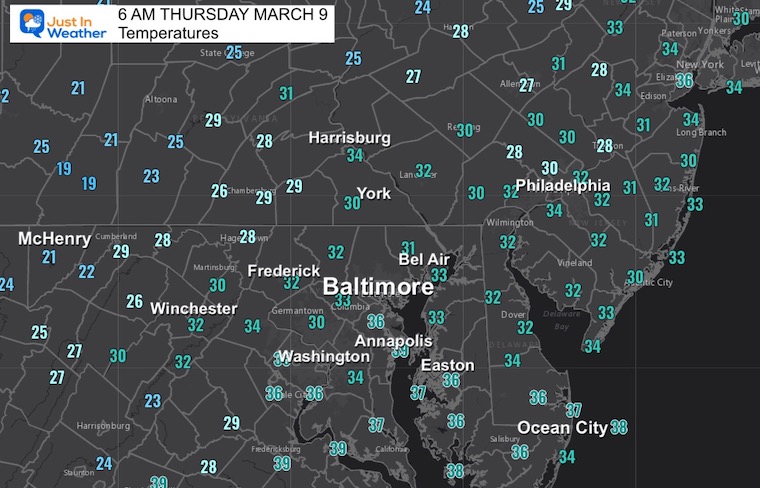
Morning Temperatures
Colder air is back in place with many more near or below freezing.
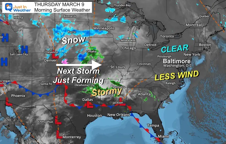
Morning Surface Weather
If you liked the last two days with the exception of the wind, we will ease the air flow today and keep the sun. The next storm is just starting to form and we will get that arriving during Friday morning. More on that below.
Afternoon
Yes, another day well above freezing, but still near or slightly below average.
Subscribe for eMail Alerts
Weather posts straight to your inbox
Sign up and be the first to know!
CLIMATE DATA
TODAY March 9
Normal Low in Baltimore: 32ºF
Record 10ºF in 1960
SNOW: 7.8” in 1976
Normal High in Baltimore: 52ºF
Record 82ºF in 2016
REPORT: March Snow and Extreme Weather History
March Snow and Extreme Weather History
Friday: 1st Of 2 Storms
Animation: Friday Morning to Monday Evening
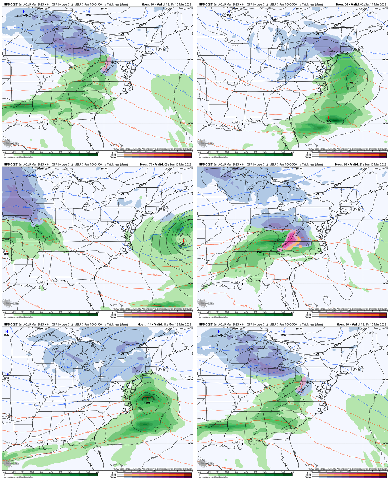
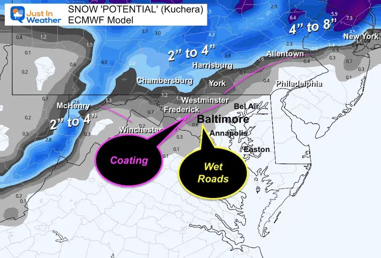
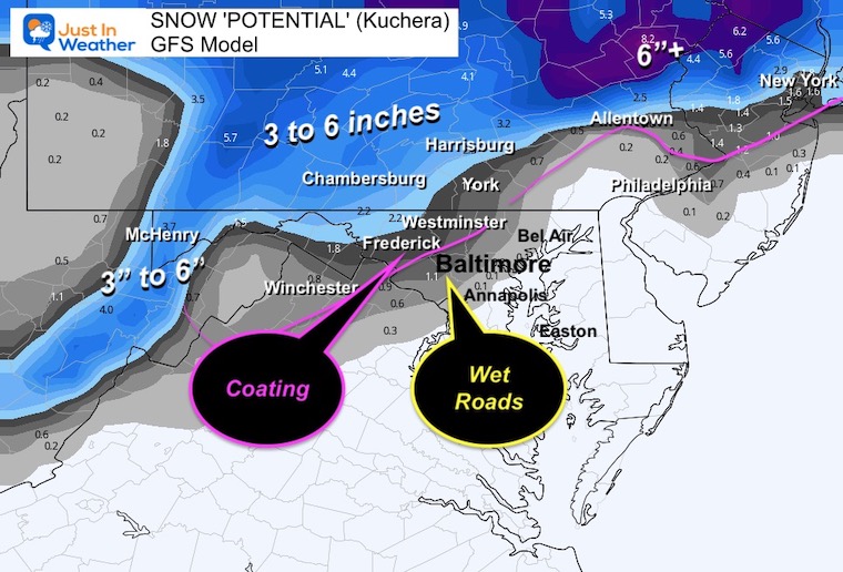
This GFS Model shows the development of two systems with the edge of the snow into central Maryland. This may look impressive, but it’s on the edge of marginal temperatures both times. Climatological favored inland areas have a better chance for stickage or impact.
My First Call
I made the adjustment to question the Saturday push of snow to Delmarva.
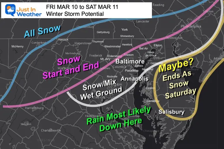
Realistic DOUBTS About Snowfall In March
- Snow falling during the day has more hindrance to stick with the higher March sun angle.
- The ground will have a few nights of freezing temps to chill, but it will still retain plenty of latent warmth.
- The track of the Low in Pennsylvania can often result with the mountains breaking up the moisture or warming for central Maryland.
- The bias of this model (among others) all winter, has been to plot storms farther south than they verify.
If you want snow, you want the track farther south than shown here. If this ends up north, it would diminish snow chances.
Finally: This is favorable for inland areas AWAY from the Chesapeake Bay and in the higher hills. This does not favor urban, coastal, or Delmarva locations.
Friday Morning
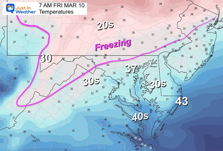
Temperatures
The FREEZING LINE will be confined to the normal colder inland areas. NOT metro Baltimore/Central Maryland.
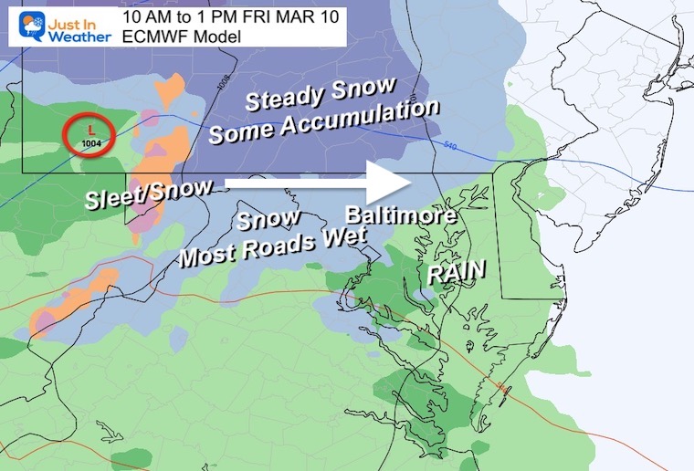
Start Time:
Here is a map suggesting 10 AM to 1 PM. We could see the leading edge as early as 8 AM for the western suburbs. That may be early enough for an early coating of snow… but the midday time frame will be working AGAINST high sun angle and warmer temps.
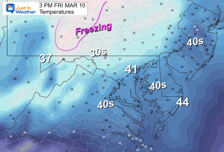
Friday Afternoon Temperatures
The freezing air will retreat to the high mountains of central PA. Locally, our colder areas will reach the upper 30s. Urban areas reach near 40ºF.
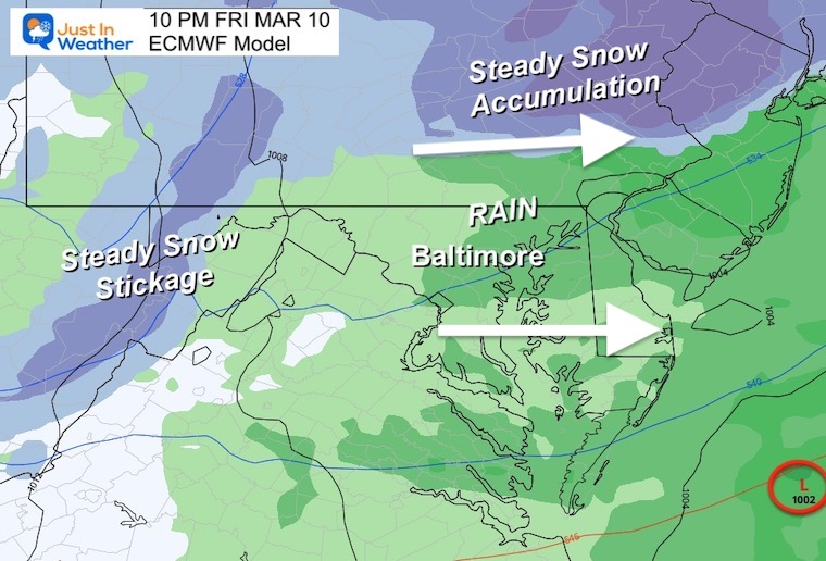
Friday Night
The track of the storm to our north will bring the rain line into southern PA. Traveling north of the PA turnpike or West of the I-68 split may remain snowy with accumulation and road impacts.
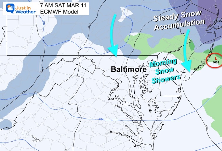
Saturday Morning
At this time the Coastal Storm will be cranking. The strength and proximity to the coast will determine if it can pull snow showers down into Maryland.
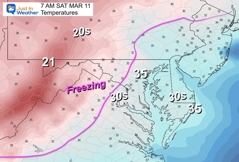
Morning Temperatures
The freezing line will be approaching from the west. If there is snow early in the day, there may be some coating on the grassy areas.
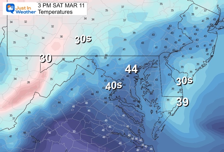
Afternoon Temperatures
As the storm moves away, gusty winds and a cool day will prevail.
Computer Model Forecasts
ECMWF Model
GFS Model
Looking Ahead
Both the GFS and European Models have a second event Sunday night into Monday morning. This may be a repeat for the same areas. What you see Friday may be what you see again then.
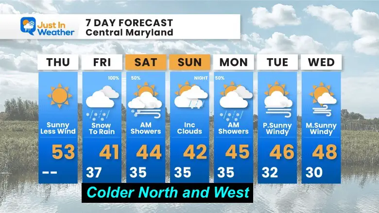
7 Day Forecast
I forecast for the region AND it will be COLDER NORTH AND WEST.
Subscribe for eMail Alerts
Weather posts straight to your inbox
Sign up and be the first to know!
IN CASE YOU MISSED IT
My REALISTIC Expectations for the COLD OUTLOOK
Also See:
Winter History: Low Snow And Late Starts
See my research based on Baltimore data since 1883.
RESTATING MY MESSAGE ABOUT DYSLEXIA
I am aware there are some spelling and grammar typos, and occasional other glitches. I take responsibility for my mistakes, and even the computer glitches I may miss.
I have made a few public statements over the years, but if you are new here you may have missed it:
I have dyslexia, and found out during my second year at Cornell University. It didn’t stop me from getting my meteorology degree, and being first to get the AMS CBM in the Baltimore/Washington region. One of my professors told me that I had made it that far without knowing, and to not let it be a crutch going forward. That was Mark Wysocki and he was absolutely correct!
I do miss my mistakes in my own proofreading. The autocorrect spell check on my computer sometimes does an injustice to make it worse. I also can make mistakes in forecasting. No one is perfect predicting the future.
All of the maps and information are accurate. The ‘wordy’ stuff can get sticky.
There has been no editor that can check my work when I needed it and have it ready to send out in a newsworthy timeline. Barbara Werner is a member of the web team that helps me maintain this site. She has taken it upon herself to edit typos, when she is able. That could be AFTER you read this.
I accept this and perhaps proves what you read is really from me…
It’s part of my charm.
#FITF
STEM Assemblies/In School Fields Trips Are Back
Click to see more and ‘Book’ a visit to your school
My Winter Outlook: Not A Typical La Niña!
I see many factors to support colder influence with multiple systems. Early and later in winter. Check it out. https://justinweather.com/2022/11/22/winter-outlook-2023-for-snow-not-typical-la-nina-plus-polar-vortex-disruption/
Also See The Winter Outlook Series:
Farmer’s Almanac Comparison
September Starts Meteorological Autumn: Weather Climate Stats For Maryland at Baltimore
Triple Dip La Niña Winter
https://justinweather.com/2022/09/09/winter-outlook-2023-la-nina-triple-dip-expectations/
CONNECTION TO WINTER?
If you want a snowy winter, this is what you might want to look for in the rest of the tropical season. https://justinweather.com/2022/08/31/record-august-for-no-named-tropical-storms-closer-look-at-snow-following/
Woolly Bear Caterpillars
https://justinweather.com/2022/10/25/winter-weather-outlook-from-the-wooly-bear-caterpillar/
Persimmon Seeds
Click to see Top 20 and MORE
Normals And Records: Maryland and Baltimore Climate History
Please share your thoughts, best weather pics/videos, or just keep in touch via social media
-
-
Facebook: Justin Berk, Meteorologist
-
Twitter: @JustinWeather
-
Instagram: justinweather
-


